48:
73:
234:
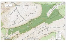
230:, the wilderness is bounded on the west by Va 623, on the east by Va 615, on the north by Va 620 and on the northwest by the crest of Garden Mountain. A 9.7 mile section of the Appalachian Trail gives access to the area, extending from the trailhead on Va 615 to the trailhead at Va 623. In addition, there are abandoned logging roads, an old railroad grade, and a two-mile, blue-blazed "Low Water Trail" along Wolf Creek that can be used to explore the area.
80:
55:
384:
The wilderness is on the outer flank of an ancient, domed-shape geologic structure that has eroded to leave only the steep sides of the original rock arch. Burkes Garden, composed of older limestone deep inside the dome, was exposed by the erosion of the dome. The AT, as it travels south along Garden
377:
Garden and Brushy
Mountains, the principal ridges in the wilderness, are part of the Ridge and Valley section of the central Appalachians, a section marked by ridges of sandstone and shale separated by shale valleys. Steep slopes produce a high density of streams flowing into Hunting Camp Creek and
400:
There are some regulations to maintain the integrity of the area. For example, motorized equipment, motor vehicles and mountain bikes are prohibited, group size is limited to ten people, and limits are placed on camping.
2241:
194:, it helps to preserve a variety of natural life forms and contributes to a diversity of plant and animal gene pools. Over half of the ecosystems in the United States exist within designated wilderness.
1452:
1256:
47:
2319:
2236:
2060:
72:
1155:
803:
733:
715:
1054:
886:
813:
1004:
685:
758:
1875:
2170:
1437:
2314:
2263:
1720:
1104:
1049:
856:
1960:
1127:
394:
2246:
1467:
1178:
743:
783:
1745:
1119:
2324:
2304:
2050:
1019:
1009:
619:
393:
Created in 2009, the wilderness now has a size of 8471 acres. It is managed by the U.S. Forest
Service as part of the Eastern Divide Ranger District of the
123:
2200:
1930:
1825:
1074:
748:
2005:
1715:
2278:
2273:
2040:
1925:
1900:
1094:
678:
2329:
2180:
2120:
2055:
2020:
1740:
1705:
2175:
2065:
1950:
1895:
1815:
1765:
1188:
1109:
846:
793:
773:
706:
191:
2145:
2140:
2115:
2100:
2090:
2075:
2025:
1945:
1920:
1790:
1710:
1700:
838:
788:
753:
2309:
2015:
2000:
1905:
1885:
1810:
1775:
1665:
1477:
1145:
1089:
1069:
1059:
1044:
876:
561:
479:
2221:
2165:
2095:
1890:
1880:
1860:
1855:
1850:
1845:
1800:
1750:
1690:
1079:
694:
671:
1785:
515:
2185:
2085:
2045:
2030:
1990:
1955:
1940:
1915:
1835:
1805:
1795:
1770:
1760:
1755:
1675:
1246:
1163:
2130:
2105:
1995:
1975:
1965:
1735:
1685:
1635:
1530:
1099:
1084:
981:
828:
818:
292:
The 500-acre Little Wolf Creek
Primitive Management Area, is part of the wilderness, with 33 species of birds including 10 species of
2135:
2080:
2010:
1910:
1870:
1840:
1830:
1039:
1029:
936:
768:
2150:
1820:
1730:
1585:
1492:
1447:
1397:
1322:
1292:
2268:
2195:
2155:
2110:
2070:
1985:
1780:
1168:
881:
823:
606:
2160:
1935:
1695:
1522:
1462:
906:
901:
28:
2125:
1865:
1615:
921:
866:
2190:
653:
2035:
1570:
1352:
1347:
1279:
1216:
931:
861:
593:
2231:
1595:
1201:
1064:
851:
307:
In Little Wolf Creek Valley, interspersed acidic and alkaline soils support a variety of ferns and flowers, including
1725:
1680:
1565:
1507:
1417:
1287:
1231:
1173:
975:
926:
916:
911:
891:
871:
763:
242:
2299:
1560:
1472:
1412:
1407:
1402:
1226:
1196:
896:
285:
along the dry ridge crests of Brushy
Mountain and Garden Mountain. In addition there are 522 acres of possible
1640:
1620:
1362:
1357:
1342:
1206:
1137:
723:
1645:
1590:
1580:
1497:
1387:
1317:
1312:
1236:
960:
502:
420:
210:
201:, the wilderness spans two remote watersheds, giving the trail one of its wildest stretches in the southern
540:
Revised Land and
Resource Management Plan for the Jefferson National Forest, Management Bulletin R8-MB 115E
1575:
1555:
1535:
1457:
1442:
1422:
1382:
1367:
1332:
1297:
1270:
1014:
991:
415:
227:
187:
100:
1625:
1610:
1550:
1540:
1512:
1427:
1392:
1337:
202:
1650:
1605:
1502:
1482:
1377:
1372:
1307:
1221:
1545:
1432:
174:
1600:
1327:
1302:
954:
580:
556:(6th ed.). Harpersville, West Virginia: Appalachian Trail Conference. 2015. pp. 62–66.
542:. Roanoke, Virginia: Jefferson National Forest, US Department of Agriculture. pp. C-67–C-72.
233:
1655:
1630:
1211:
999:
557:
475:
286:
198:
946:
297:
332:
223:
111:
32:
970:
516:
Blacksburg, New River Valley [George
Washington and Jefferson National Forests]
381:
Elevations range from 2380 feet on
Hunting Camp Creek to 4120 feet on Garden Mountain.
301:
2293:
1487:
358:
350:
316:
308:
366:
354:
336:
328:
278:
258:
658:
378:
Little Wolf Creek. Laurel Creek flows along the eastern edge of the wilderness.
778:
346:
340:
324:
320:
262:
965:
663:
410:
274:
648:
632:
138:
125:
620:
Nomination Format for
Protected Species Listing - phoxinus_tennesseensis.pdf
362:
312:
254:
698:
293:
270:
266:
385:
Mountain, offers an unobstructed view across the bowl of Burkes Garden.
349:
in the wetlands of upper
Hunting Camp Creek provide a good habitat for
282:
190:
of
Congress to maintain its present, natural condition. As part of the
503:
Wilderness.net - Hunting Camp Creek Wilderness - Rules and Regulations
474:. Richmond, Virginia: Sierra Club Virginia Chapter. pp. 36–39.
232:
667:
581:
Hunting Camp Creek Wilderness - Virginia Wilderness Committee
440:
277:
in valleys of both Hunting Camp Creek and Wolf Creek; and
2237:
National Register of Historic Places listings in Virginia
79:
54:
2220:
2213:
1974:
1664:
1521:
1278:
1269:
1245:
1187:
1154:
1136:
1118:
1028:
990:
945:
837:
802:
732:
714:
705:
594:
Little Wolf Creek Primitive Management Area | VDGIF
170:
162:
154:
117:
107:
96:
21:
2264:Virginia Department of Conservation and Recreation
575:
573:
554:Appalachian Trail Guide, Southwest Virginia, Map 2
304:occurs in the area, often in ponds below springs.
2320:George Washington and Jefferson National Forests
497:
495:
493:
491:
395:George Washington and Jefferson National Forests
205:with an abundance of wildflowers and birdlife.
679:
8:
300:. The strikingly, orange-colored, imperiled
2217:
1275:
711:
686:
672:
664:
631:Chrosomus tennesseensis (Tennessee Dace):
18:
2315:Protected areas of Bland County, Virginia
2279:Virginia Department of Wildlife Resources
2274:Virginia Department of Historic Resources
465:
463:
461:
459:
457:
237:Boundary of Hunting Camp Creek Wilderness
633:Chrosomus tennesseensis (Tennessee Dace)
432:
649:Flora of Little Wolf and Laurel Creeks
534:
532:
530:
528:
526:
524:
1146:Mount Rogers National Recreation Area
7:
1179:Wolf Trap NP for the Performing Arts
806:Battlefields & Battlefield Parks
95:
2325:Protected areas established in 2009
2305:Protected areas of the Appalachians
1164:Assateague Island National Seashore
814:Fredericksburg and Spotsylvania NMP
982:George Washington Memorial Parkway
241:The wilderness is bordered by the
14:
1005:Captain John Smith Chesapeake NHT
470:Bamford, Sherman (October 2014).
2061:Goshen and Little North Mountain
78:
71:
53:
46:
2330:2009 establishments in Virginia
2269:Virginia Department of Forestry
1169:Chesapeake Bay Gateways Network
1128:George Washington and Jefferson
784:George Washington Birthplace NM
759:Cedar Creek and Belle Grove NHP
579:Virginia Wilderness Committee:
514:Blacksburg, New River Valley :
161:
106:
1138:USFS National Recreation Areas
736:Historic Sites & Monuments
1:
184:Hunting Camp Creek Wilderness
87:Show map of the United States
22:Hunting Camp Creek Wilderness
2310:Wilderness areas of Virginia
1721:Cape Charles Coastal Habitat
635:, accessdate: March 26, 2017
622:, accessdate: March 26, 2017
618:phoxinus_tennesseensis.pdf:
609:, accessdate: March 26, 2017
596:, accessdate: March 26, 2017
583:, accessdate: March 26, 2017
518:, accessdate: March 26, 2017
505:, accessdate: March 26, 2017
186:is an area protected by the
2247:National Historic Landmarks
2232:Virginia Landmarks Register
158:8,471 acres (3,428 ha)
2346:
2171:Smith Mountain Cooperative
1961:William B. Trower Bayshore
1478:Staunton River Battlefield
1438:Sailor's Creek Battlefield
1174:Prince William Forest Park
976:Rocky Knob Recreation Area
764:Claude Moore Colonial Farm
744:Appomattox Court House NHP
734:National Historical Parks,
243:Garden Mountain Wilderness
16:Protected area in Virginia
2259:
1468:Southwest Virginia Museum
1105:Rappahannock River Valley
1050:Eastern Shore of Virginia
222:Lying five miles west of
40:
26:
1876:Mark's and Jack's Island
1020:Star-Spangled Banner NHT
1010:Overmountain Victory NHT
804:National Military Parks,
253:Forests species include
208:The area is part of the
1746:Chestnut Creek Wetlands
961:Blue Ridge Music Center
754:Booker T. Washington NM
501:Rules and Regulations:
421:Garden Mountain Cluster
211:Garden Mountain Cluster
103:Virginia, United States
1015:Potomac Heritage Trail
472:18 Wonders of Virginia
416:Eastern Wilderness Act
238:
228:Bland County, Virginia
188:Eastern Wilderness Act
1931:Piney Grove Flatwoods
1826:Folly Mills Creek Fen
1636:Prince Edward-Gallion
1531:Appomattox-Buckingham
1323:Culpeper Battlefields
236:
139:37.08795°N 81.24977°W
1716:Camp Branch Wetlands
794:Maggie L. Walker NHS
331:. In addition, rare
62:Show map of Virginia
2222:Registered Historic
2051:G. Richard Thompson
1926:Pedlar Hills Glades
1901:North Landing River
1463:Smith Mountain Lake
839:National Cemeteries
333:roundleaf goldenrod
296:and two species of
218:Location and access
175:U.S. Forest Service
144:37.08795; -81.24977
135: /
2224:Places in Virginia
2201:White Oak Mountain
1741:Cherry Orchard Bog
1706:Bull Run Mountains
1247:National Estuarine
1075:Great Dismal Swamp
955:Blue Ridge Parkway
774:Cumberland Gap NHP
659:Wilderness Connect
239:
2287:
2286:
2255:
2254:
2209:
2208:
2006:Chester F. Phelps
1951:Savage Neck Dunes
1896:New Point Comfort
1816:Elklick Woodlands
1766:Cleveland Barrens
1353:High Bridge Trail
1348:Grayson Highlands
1298:Breaks Interstate
1265:
1264:
1249:Research Reserves
1000:Appalachian Trail
947:National Parkways
789:Harpers Ferry NHP
563:978-1-889386-93-5
481:978-0-926487-79-6
441:"Why Wilderness?"
287:Old-growth forest
199:Appalachian Trail
197:Traversed by the
192:wilderness system
180:
179:
108:Nearest city
2337:
2300:IUCN Category Ib
2218:
2156:Robert W. Duncan
2111:Mattaponi Bluffs
2041:Fairystone Farms
1978:Management Areas
1946:Redrock Mountain
1921:Parramore Island
1791:Cumberland Marsh
1711:Bush Mill Stream
1701:Buffalo Mountain
1586:Devil's Backbone
1453:Shenandoah River
1403:Middle Peninsula
1276:
1202:James River Face
1189:Wilderness Areas
1120:National Forests
1095:Plum Tree Island
1065:Fisherman Island
1032:Wildlife Refuges
712:
688:
681:
674:
665:
636:
629:
623:
616:
610:
603:
597:
590:
584:
577:
568:
567:
550:
544:
543:
536:
519:
512:
506:
499:
486:
485:
467:
452:
451:
449:
447:
437:
150:
149:
147:
146:
145:
140:
136:
133:
132:
131:
128:
88:
82:
81:
75:
63:
57:
56:
50:
19:
2345:
2344:
2340:
2339:
2338:
2336:
2335:
2334:
2290:
2289:
2288:
2283:
2251:
2223:
2205:
2181:T. M. Gathright
2121:Mockhorn Island
2056:Game Farm Marsh
2021:Clinch Mountain
1977:
1970:
1906:Northwest River
1886:Mutton Hunk Fen
1866:Lyndhurst Ponds
1811:Difficult Creek
1781:Crawford's Knob
1776:Cowbane Prairie
1667:
1660:
1571:Conway Robinson
1517:
1508:Wilderness Road
1418:New River Trail
1288:Bear Creek Lake
1261:
1248:
1241:
1183:
1156:Other NPS Areas
1150:
1132:
1114:
1031:
1024:
992:National Trails
986:
941:
833:
805:
798:
749:Arlington House
735:
728:
701:
695:Protected areas
692:
645:
640:
639:
630:
626:
617:
613:
604:
600:
591:
587:
578:
571:
564:
552:
551:
547:
538:
537:
522:
513:
509:
500:
489:
482:
469:
468:
455:
445:
443:
439:
438:
434:
429:
407:
391:
375:
337:fringed gentian
251:
249:Natural History
224:Bland, Virginia
220:
143:
141:
137:
134:
129:
126:
124:
122:
121:
112:Bland, Virginia
92:
91:
90:
89:
86:
85:
84:
83:
66:
65:
64:
61:
60:
59:
58:
36:
33:wilderness area
17:
12:
11:
5:
2343:
2341:
2333:
2332:
2327:
2322:
2317:
2312:
2307:
2302:
2292:
2291:
2285:
2284:
2282:
2281:
2276:
2271:
2266:
2260:
2257:
2256:
2253:
2252:
2250:
2249:
2244:
2239:
2234:
2228:
2226:
2215:
2211:
2210:
2207:
2206:
2204:
2203:
2198:
2193:
2188:
2183:
2178:
2176:Stewarts Creek
2173:
2168:
2163:
2158:
2153:
2148:
2143:
2138:
2133:
2128:
2123:
2118:
2113:
2108:
2103:
2098:
2093:
2088:
2083:
2078:
2073:
2068:
2066:Hardware River
2063:
2058:
2053:
2048:
2043:
2038:
2033:
2028:
2023:
2018:
2013:
2008:
2003:
1998:
1993:
1988:
1982:
1980:
1972:
1971:
1969:
1968:
1963:
1958:
1953:
1948:
1943:
1938:
1933:
1928:
1923:
1918:
1913:
1908:
1903:
1898:
1893:
1891:Naked Mountain
1888:
1883:
1881:Mount Joy Pond
1878:
1873:
1868:
1863:
1861:Johnsons Creek
1858:
1856:Hughlett Point
1853:
1851:Hickory Hollow
1848:
1846:Grayson Glades
1843:
1838:
1833:
1828:
1823:
1818:
1813:
1808:
1803:
1801:Deep Run Ponds
1798:
1793:
1788:
1783:
1778:
1773:
1768:
1763:
1758:
1753:
1751:Chestnut Ridge
1748:
1743:
1738:
1733:
1728:
1723:
1718:
1713:
1708:
1703:
1698:
1693:
1691:Big Spring Bog
1688:
1683:
1678:
1672:
1670:
1662:
1661:
1659:
1658:
1653:
1648:
1643:
1638:
1633:
1628:
1623:
1618:
1613:
1608:
1603:
1598:
1596:First Mountain
1593:
1588:
1583:
1578:
1573:
1568:
1563:
1558:
1553:
1548:
1543:
1538:
1533:
1527:
1525:
1519:
1518:
1516:
1515:
1510:
1505:
1500:
1495:
1490:
1485:
1480:
1475:
1473:Staunton River
1470:
1465:
1460:
1455:
1450:
1445:
1440:
1435:
1430:
1425:
1420:
1415:
1413:Natural Tunnel
1410:
1408:Natural Bridge
1405:
1400:
1395:
1390:
1385:
1380:
1375:
1370:
1365:
1360:
1355:
1350:
1345:
1340:
1335:
1330:
1325:
1320:
1315:
1310:
1305:
1300:
1295:
1290:
1284:
1282:
1273:
1267:
1266:
1263:
1262:
1260:
1259:
1257:Chesapeake Bay
1253:
1251:
1243:
1242:
1240:
1239:
1234:
1229:
1227:Rough Mountain
1224:
1219:
1217:Ramsey's Draft
1214:
1209:
1204:
1199:
1197:Barbours Creek
1193:
1191:
1185:
1184:
1182:
1181:
1176:
1171:
1166:
1160:
1158:
1152:
1151:
1149:
1148:
1142:
1140:
1134:
1133:
1131:
1130:
1124:
1122:
1116:
1115:
1113:
1112:
1110:Wallops Island
1107:
1102:
1097:
1092:
1087:
1082:
1077:
1072:
1067:
1062:
1057:
1052:
1047:
1042:
1036:
1034:
1026:
1025:
1023:
1022:
1017:
1012:
1007:
1002:
996:
994:
988:
987:
985:
984:
979:
973:
971:Peaks of Otter
968:
963:
957:
951:
949:
943:
942:
940:
939:
934:
929:
924:
919:
914:
909:
904:
899:
894:
889:
887:Fredericksburg
884:
879:
874:
869:
864:
859:
854:
849:
843:
841:
835:
834:
832:
831:
826:
821:
816:
810:
808:
800:
799:
797:
796:
791:
786:
781:
779:Fort Monroe NM
776:
771:
766:
761:
756:
751:
746:
740:
738:
730:
729:
727:
726:
720:
718:
716:National Parks
709:
703:
702:
693:
691:
690:
683:
676:
668:
662:
661:
656:
651:
644:
643:External links
641:
638:
637:
624:
611:
605:Explore Data:
598:
585:
569:
562:
545:
520:
507:
487:
480:
453:
431:
430:
428:
425:
424:
423:
418:
413:
406:
403:
390:
387:
374:
371:
341:Fraser's sedge
302:Tennessee dace
250:
247:
219:
216:
178:
177:
172:
168:
167:
164:
160:
159:
156:
152:
151:
119:
115:
114:
109:
105:
104:
98:
94:
93:
77:
76:
70:
69:
68:
67:
52:
51:
45:
44:
43:
42:
41:
38:
37:
27:
24:
23:
15:
13:
10:
9:
6:
4:
3:
2:
2342:
2331:
2328:
2326:
2323:
2321:
2318:
2316:
2313:
2311:
2308:
2306:
2303:
2301:
2298:
2297:
2295:
2280:
2277:
2275:
2272:
2270:
2267:
2265:
2262:
2261:
2258:
2248:
2245:
2243:
2240:
2238:
2235:
2233:
2230:
2229:
2227:
2225:
2219:
2216:
2212:
2202:
2199:
2197:
2194:
2192:
2189:
2187:
2184:
2182:
2179:
2177:
2174:
2172:
2169:
2167:
2164:
2162:
2159:
2157:
2154:
2152:
2149:
2147:
2146:Ragged Island
2144:
2142:
2141:Princess Anne
2139:
2137:
2134:
2132:
2129:
2127:
2126:Oakley Forest
2124:
2122:
2119:
2117:
2116:Merrimac Farm
2114:
2112:
2109:
2107:
2104:
2102:
2099:
2097:
2094:
2092:
2091:Horsepen Lake
2089:
2087:
2084:
2082:
2079:
2077:
2076:Hidden Valley
2074:
2072:
2069:
2067:
2064:
2062:
2059:
2057:
2054:
2052:
2049:
2047:
2044:
2042:
2039:
2037:
2034:
2032:
2029:
2027:
2026:Crooked Creek
2024:
2022:
2019:
2017:
2014:
2012:
2009:
2007:
2004:
2002:
1999:
1997:
1994:
1992:
1989:
1987:
1984:
1983:
1981:
1979:
1973:
1967:
1964:
1962:
1959:
1957:
1956:Unthanks Cave
1954:
1952:
1949:
1947:
1944:
1942:
1941:Poor Mountain
1939:
1937:
1934:
1932:
1929:
1927:
1924:
1922:
1919:
1917:
1916:Parkers Marsh
1914:
1912:
1909:
1907:
1904:
1902:
1899:
1897:
1894:
1892:
1889:
1887:
1884:
1882:
1879:
1877:
1874:
1872:
1869:
1867:
1864:
1862:
1859:
1857:
1854:
1852:
1849:
1847:
1844:
1842:
1839:
1837:
1836:Grafton Ponds
1834:
1832:
1829:
1827:
1824:
1822:
1819:
1817:
1814:
1812:
1809:
1807:
1806:Dendron Swamp
1804:
1802:
1799:
1797:
1796:Dameron Marsh
1794:
1792:
1789:
1787:
1784:
1782:
1779:
1777:
1774:
1772:
1771:Clover Hollow
1769:
1767:
1764:
1762:
1761:Chub Sandhill
1759:
1757:
1756:Chotank Creek
1754:
1752:
1749:
1747:
1744:
1742:
1739:
1737:
1734:
1732:
1729:
1727:
1724:
1722:
1719:
1717:
1714:
1712:
1709:
1707:
1704:
1702:
1699:
1697:
1694:
1692:
1689:
1687:
1684:
1682:
1679:
1677:
1676:Antioch Pines
1674:
1673:
1671:
1669:
1663:
1657:
1654:
1652:
1649:
1647:
1644:
1642:
1639:
1637:
1634:
1632:
1629:
1627:
1624:
1622:
1619:
1617:
1616:Moore's Creek
1614:
1612:
1609:
1607:
1604:
1602:
1599:
1597:
1594:
1592:
1589:
1587:
1584:
1582:
1579:
1577:
1574:
1572:
1569:
1567:
1566:Chilton Woods
1564:
1562:
1559:
1557:
1554:
1552:
1549:
1547:
1544:
1542:
1539:
1537:
1534:
1532:
1529:
1528:
1526:
1524:
1523:State forests
1520:
1514:
1511:
1509:
1506:
1504:
1501:
1499:
1496:
1494:
1491:
1489:
1488:Tabb Monument
1486:
1484:
1481:
1479:
1476:
1474:
1471:
1469:
1466:
1464:
1461:
1459:
1456:
1454:
1451:
1449:
1446:
1444:
1441:
1439:
1436:
1434:
1431:
1429:
1426:
1424:
1421:
1419:
1416:
1414:
1411:
1409:
1406:
1404:
1401:
1399:
1396:
1394:
1391:
1389:
1386:
1384:
1381:
1379:
1376:
1374:
1371:
1369:
1366:
1364:
1363:Hungry Mother
1361:
1359:
1358:Holliday Lake
1356:
1354:
1351:
1349:
1346:
1344:
1343:First Landing
1341:
1339:
1336:
1334:
1331:
1329:
1326:
1324:
1321:
1319:
1316:
1314:
1311:
1309:
1306:
1304:
1301:
1299:
1296:
1294:
1291:
1289:
1286:
1285:
1283:
1281:
1277:
1274:
1272:
1268:
1258:
1255:
1254:
1252:
1250:
1244:
1238:
1235:
1233:
1230:
1228:
1225:
1223:
1220:
1218:
1215:
1213:
1210:
1208:
1207:Mountain Lake
1205:
1203:
1200:
1198:
1195:
1194:
1192:
1190:
1186:
1180:
1177:
1175:
1172:
1170:
1167:
1165:
1162:
1161:
1159:
1157:
1153:
1147:
1144:
1143:
1141:
1139:
1135:
1129:
1126:
1125:
1123:
1121:
1117:
1111:
1108:
1106:
1103:
1101:
1098:
1096:
1093:
1091:
1088:
1086:
1083:
1081:
1078:
1076:
1073:
1071:
1068:
1066:
1063:
1061:
1058:
1056:
1053:
1051:
1048:
1046:
1043:
1041:
1038:
1037:
1035:
1033:
1027:
1021:
1018:
1016:
1013:
1011:
1008:
1006:
1003:
1001:
998:
997:
995:
993:
989:
983:
980:
977:
974:
972:
969:
967:
964:
962:
958:
956:
953:
952:
950:
948:
944:
938:
935:
933:
930:
928:
925:
923:
920:
918:
915:
913:
910:
908:
905:
903:
900:
898:
895:
893:
890:
888:
885:
883:
882:Fort Harrison
880:
878:
875:
873:
870:
868:
865:
863:
860:
858:
855:
853:
850:
848:
845:
844:
842:
840:
836:
830:
827:
825:
824:Petersburg NB
822:
820:
817:
815:
812:
811:
809:
807:
801:
795:
792:
790:
787:
785:
782:
780:
777:
775:
772:
770:
767:
765:
762:
760:
757:
755:
752:
750:
747:
745:
742:
741:
739:
737:
731:
725:
722:
721:
719:
717:
713:
710:
708:
704:
700:
696:
689:
684:
682:
677:
675:
670:
669:
666:
660:
657:
655:
652:
650:
647:
646:
642:
634:
628:
625:
621:
615:
612:
608:
602:
599:
595:
589:
586:
582:
576:
574:
570:
565:
559:
555:
549:
546:
541:
535:
533:
531:
529:
527:
525:
521:
517:
511:
508:
504:
498:
496:
494:
492:
488:
483:
477:
473:
466:
464:
462:
460:
458:
454:
442:
436:
433:
426:
422:
419:
417:
414:
412:
409:
408:
404:
402:
398:
396:
388:
386:
382:
379:
372:
370:
368:
364:
360:
359:Indian physic
356:
352:
351:cinnamon fern
348:
344:
342:
338:
334:
330:
326:
322:
318:
317:Canada violet
314:
310:
309:New York fern
305:
303:
299:
295:
290:
288:
284:
280:
276:
272:
268:
264:
260:
256:
248:
246:
245:on the west.
244:
235:
231:
229:
225:
217:
215:
213:
212:
206:
204:
200:
195:
193:
189:
185:
176:
173:
171:Administrator
169:
165:
157:
153:
148:
120:
116:
113:
110:
102:
99:
74:
49:
39:
34:
30:
29:IUCN category
25:
20:
2016:Chickahominy
2001:Briery Creek
1966:Wreck Island
1736:The Channels
1686:Bethel Beach
1666:Natural Area
1561:Chesterfield
1498:Westmoreland
1318:Clinch River
1313:Claytor Lake
1237:Three Ridges
1232:Saint Mary's
1090:Occoquan Bay
1070:Glenn Martin
1060:Featherstone
1045:Chincoteague
907:Poplar Grove
902:Hampton VAMC
829:Richmond NBP
819:Manassas NBP
769:Colonial NHP
627:
614:
607:Explore Data
601:
588:
553:
548:
539:
510:
471:
444:. Retrieved
435:
399:
392:
383:
380:
376:
367:flame azalea
355:red catchfly
347:Beaver ponds
345:
329:black cohosh
306:
291:
279:chestnut oak
259:tulip poplar
252:
240:
221:
209:
207:
203:Appalachians
196:
183:
181:
101:Bland County
2166:Short Hills
2096:James River
1911:Ogdens Cave
1871:Magothy Bay
1841:Grassy Hill
1831:Goshen Pass
1786:Crow's Nest
1641:Sandy Point
1621:Niday Place
1458:Sky Meadows
1443:Seven Bends
1423:Occoneechee
1388:Machicomoco
1383:Leesylvania
1368:James River
1333:Fairy Stone
1280:State parks
1080:James River
922:Seven Pines
867:Cold Harbor
857:Balls Bluff
343:are found.
325:foam flower
321:wood nettle
263:sugar maple
163:Established
142: /
118:Coordinates
2294:Categories
2191:Ware Creek
2186:Turkeycock
2101:Land's End
2086:Hog Island
2046:Featherfin
2031:Dick Cross
1991:Big Survey
1821:False Cape
1731:The Cedars
1696:Blackwater
1646:South Quay
1591:Dragon Run
1581:Cumberland
1513:York River
1493:Twin Lakes
1448:Shot Tower
1428:Pocahontas
1398:Mayo River
1393:Mason Neck
1338:False Cape
1293:Belle Isle
1055:Mason Neck
966:Mabry Mill
932:Winchester
862:City Point
847:Alexandria
724:Shenandoah
427:References
411:Wilderness
389:Management
373:Topography
275:white pine
269:, Frasier
130:81°14′59″W
127:37°05′17″N
2131:Pettigrew
2106:Mattaponi
2036:Doe Creek
1996:Big Woods
1726:Cave Hill
1681:Bald Knob
1668:Preserves
1576:Crawfords
1556:Charlotte
1536:Big Woods
1503:Widewater
1483:Sweet Run
1378:Lake Anna
1373:Kiptopeke
1308:Chippokes
1222:Rich Hole
1100:Presquile
1085:Nansemond
852:Arlington
654:Trail map
446:March 26,
363:columbine
313:lady fern
255:white oak
2136:Powhatan
2081:Highland
2011:Cavalier
1976:Wildlife
1936:Pinnacle
1626:Old Flat
1611:Matthews
1551:Channels
1541:Bourassa
1433:Powhatan
1040:Back Bay
1030:National
937:Yorktown
927:Staunton
917:Richmond
912:Quantico
892:Glendale
877:Danville
872:Culpeper
699:Virginia
405:See also
294:warblers
271:magnolia
267:basswood
97:Location
2242:Bridges
2151:Rapidan
1651:Whitney
1606:Lesesne
1328:Douthat
1303:Caledon
897:Hampton
707:Federal
592:VDGIF:
298:orioles
283:hickory
2196:Weston
2071:Havens
1986:Amelia
1546:Browne
1212:Priest
560:
478:
365:, and
327:, and
2214:Other
2161:Saxis
1601:Hawks
1271:State
1656:Zoar
1631:Paul
558:ISBN
476:ISBN
448:2017
339:and
281:and
273:and
182:The
166:2009
155:Area
31:Ib (
697:of
226:in
2296::
572:^
523:^
490:^
456:^
397:.
369:.
361:,
357:,
353:,
335:,
323:,
319:,
315:,
311:,
289:.
265:,
261:,
257:,
214:.
978:)
959:(
687:e
680:t
673:v
566:.
484:.
450:.
35:)
Text is available under the Creative Commons Attribution-ShareAlike License. Additional terms may apply.