177:. The name originated from the Yavapai 'ʼHakhe:la", which means "running water". The range is oriented from northeast to southwest and is approximately 32 km long and 20 km at its widest point. At the northeast are two prominent peaks, Eagle Eye Peak and Eagle Eye Mountain. One has a natural opening or bridge through it appearing as an eye high up, and is the namesake for the peaks and Aguila (Spanish for eagle). The highest point, Harquahala Peak, rises to 5,681 ft (1,732 m). Socorro Peak, 3270 ft (1,134 m), is at the southwest end of the range.
40:
1840:
1825:
325:
1835:
1845:
1820:
120:
1815:
407:
1289:
1299:
1509:
1364:
1304:
189:
1810:
1449:
1830:
1188:
1294:
698:
400:
262:
334:
1170:
416:
356:
374:
1319:
629:
267:
210:
1409:
1354:
1284:
393:
1699:
1604:
1414:
1324:
1309:
920:
424:
113:
44:
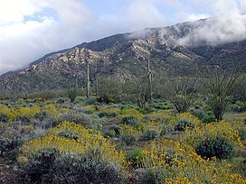
Harquahala
Mountains viewed from north side following an unusually wet spring. Bright yellow shrubs are Brittle Bush, (
1649:
1539:
1514:
1429:
1254:
1779:
1704:
1499:
1479:
1083:
193:
333:. Arizona BLM Cultural Resource Publication. Arizona State Office of the Bureau of Land Management. Archived from
1559:
1180:
782:
444:
1464:
1349:
1047:
983:
772:
662:
239:
1724:
1679:
1629:
1619:
1519:
1484:
1334:
1219:
1147:
1024:
991:
749:
731:
1599:
1434:
1399:
1274:
1229:
1093:
1065:
1039:
910:
580:
462:
243:
197:
77:
1689:
1659:
1579:
1379:
1198:
1106:
611:
490:
480:
815:
180:
The very windy summit can be reached via a rough, 4-wheel drive road. This high point was used by the
200:. Its purpose was to study variations in the solar output as a possible factor in climate prediction.
1789:
1784:
1749:
1524:
1504:
1369:
1264:
1224:
1129:
1016:
644:
526:
1734:
1709:
1664:
1624:
1609:
1589:
1584:
1529:
1419:
1404:
1389:
1374:
1239:
1162:
928:
892:
841:
787:
670:
498:
1769:
1669:
1654:
1544:
1454:
1279:
1244:
1234:
1193:
767:
716:
708:
685:
621:
598:
472:
457:
1759:
17:
1764:
1729:
1644:
1614:
1569:
1564:
1439:
1424:
1394:
1344:
1269:
968:
851:
833:
759:
562:
352:
296:
1774:
1754:
1554:
1549:
1534:
1359:
1139:
869:
544:
508:
368:
158:
45:
1739:
1674:
1574:
1314:
1029:
797:
534:
434:
174:
170:
953:
1744:
1494:
1489:
1121:
1111:
1101:
938:
741:
726:
675:
288:
1804:
1634:
1075:
973:
943:
933:
877:
777:
721:
634:
588:
452:
192:
was constructed on this summit and operated for five years before being relocated to
39:
1719:
1684:
1639:
1594:
1444:
1339:
1259:
1249:
1214:
1152:
1057:
1006:
996:
958:
900:
823:
516:
379:
1714:
1474:
1001:
948:
882:
570:
1694:
1469:
963:
905:
805:
693:
552:
185:
327:
Harqua Hala
Letters, The Story of Arizona’s Forgotten Smithsonian Observatory
300:
225:
212:
135:
122:
1329:
859:
606:
181:
652:
1384:
385:
166:
253:
mines and in the past there were extensive mines for gold and silver.
250:
67:
389:
351:
Arizona Atlas and
Gazetteer. DeLorme Mapping, Freeport, Maine.
169:, United States and are located southwest of the towns of
249:
At the southwest end of the mountain range, there are
203:
Designated in 1990, the 22,880-acre (93 km) the
1207:
1179:
1161:
1138:
1120:
1092:
1074:
1056:
1038:
1015:
982:
919:
891:
868:
850:
832:
814:
796:
758:
740:
707:
684:
661:
643:
620:
597:
579:
561:
543:
525:
507:
489:
471:
443:
423:
112:
107:
99:
91:
86:
76:
66:
58:
53:
32:
165:) are the highest mountain range in southwestern
401:
382:– Ghost Town of the Month at azghosttowns.com
8:
207:lies to the north and east of the summit at
1841:Protected areas of Maricopa County, Arizona
1826:Mountain ranges of Maricopa County, Arizona
295:. Vol. 48, no. 4. pp. 4–11.
1836:Bureau of Land Management areas in Arizona
408:
394:
386:
29:
1846:Protected areas of La Paz County, Arizona
1821:Mountain ranges of La Paz County, Arizona
279:
1816:Mountain ranges of the Sonoran Desert
190:Smithsonian Astrophysical Observatory
7:
27:Landform in southwestern Arizona, US
1290:Black Mesa (Apache-Navajo Counties)
1325:Buckskin Mountains (La Paz County)
263:List of mountain ranges of Arizona
25:
95:32 km (20 mi) NE-SW
1320:Buckskin Mountain (Arizona-Utah)
1300:Black Mountain (Maricopa County)
268:List of Arizona Wilderness Areas
38:
1510:Lime Mountain (Maricopa County}
369:Harquahala Mountains Wilderness
18:Harquahala Mountains Wilderness
1410:Gila Mountains (Graham County)
205:Harquahala Mountain Wilderness
1:
1285:Black Hills (Greenlee County)
1415:Gila Mountains (Yuma County)
1305:Black Mountain (Pima County)
921:San Francisco Volcanic Field
375:Harquahala at wilderness.net
82:3,461 ft (1,055 m)
72:5,681 ft (1,732 m)
1811:Wilderness areas of Arizona
1515:Little Harquahala Mountains
1862:
1831:Mountain ranges of Arizona
1780:West Silver Bell Mountains
1480:John the Baptist Mountains
1189:Black Mesa (Navajo County)
324:Burggraaf, Pieter (1996).
289:"The Story of Harqua Hala"
194:Table Mountain Observatory
1295:Black Mesa (Warm Springs)
188:station. Then in 1920 a
37:
1350:Cerro Colorado Mountains
984:Santa Catalina Mountains
663:Little Dragoon Mountains
1725:Tinajas Altas Mountains
1680:Sierra Madre Occidental
1520:Little Rincon Mountains
1335:Cabeza Prieta Mountains
1220:Agua Caliente Mountains
750:Mount Ballard (Arizona)
287:D. W. Grantham (1984).
103:20 km (12 mi)
1600:Painted Rock Mountains
1435:Granite Wash Mountains
1275:Bill Williams Mountain
1094:Superstition Mountains
1040:Santa Teresa Mountains
581:Hieroglyphic Mountains
226:33.82778°N 113.29778°W
198:Wrightwood, California
1690:Silver Bell Mountains
1660:Santa Maria Mountains
1380:Dos Cabezas Mountains
1107:Superstition Mountain
491:Castle Dome Mountains
1790:Wickenburg Mountains
1785:White Tank Mountains
1750:Tumacacori Mountains
1525:Lukachukai Mountains
1505:Las Guijas Mountains
1460:Harquahala Mountains
1370:Date Creek Mountains
1265:Beaver Dam Mountains
1225:Agua Dulce Mountains
1017:Santa Rita Mountains
645:Little Ajo Mountains
527:Chiricahua Mountains
417:Mountains of Arizona
231:33.82778; -113.29778
155:Harquahala Mountains
33:Harquahala Mountains
1735:Tortolita Mountains
1710:Swisshelm Mountains
1665:Sevenmile Mountains
1625:Picketpost Mountain
1610:Patagonia Mountains
1590:New Water Mountains
1585:New River Mountains
1530:Madrean Sky Islands
1450:Guadalupe Mountains
1420:Goldfield Mountains
1405:Gila Bend Mountains
1375:Dome Rock Mountains
1355:Chocolate Mountains
1310:Blackjack Mountains
1240:Artillery Mountains
1163:Whetstone Mountains
929:Black Bottom Crater
893:San Francisco Peaks
788:Sunnyslope Mountain
222: /
132: /
1770:Waterman Mountains
1700:Sugarloaf Mountain
1670:Sierra San Antonio
1655:San Luis Mountains
1605:Pajarito Mountains
1545:Moccasin Mountains
1455:Harcuvar Mountains
1280:Bitsihuitsos Butte
1245:Atascosa Mountains
1235:Aquarius Mountains
1194:Escudilla Mountain
816:Pinaleño Mountains
768:Camelback Mountain
709:McDowell Mountains
686:Mazatzal Mountains
622:Hualapai Mountains
599:Huachuca Mountains
473:Bradshaw Mountains
458:Fortification Hill
184:in the 1880s as a
136:33.817°N 113.317°W
54:Highest point
1798:
1797:
1765:Vulture Mountains
1730:Tordillo Mountain
1650:Sacaton Mountains
1645:Rawhide Mountains
1615:Peacock Mountains
1570:Mustang Mountains
1565:Muggins Mountains
1540:Mineral Mountains
1440:Growler Mountains
1430:Granite Mountains
1425:Grand Wash Cliffs
1395:Galiuro Mountains
1345:Carrizo Mountains
1270:Belmont Mountains
969:Strawberry Crater
852:Quinlan Mountains
834:Plomosa Mountains
760:Phoenix Mountains
563:Dragoon Mountains
151:
150:
114:Range coordinates
16:(Redirected from
1853:
1775:Weaver Mountains
1755:Virgin Mountains
1705:Sunset Mountains
1555:Mohawk Mountains
1550:Mohave Mountains
1535:Mescal Mountains
1500:Laguna Mountains
1365:Coyote Mountains
1360:Copper Mountains
1255:Baboquivari Peak
1140:Tucson Mountains
1084:Granite Mountain
870:Rincon Mountains
545:Chuska Mountains
509:Cerbat Mountains
427:(Yavapai County)
410:
403:
396:
387:
348:
346:
345:
339:
332:
311:
310:
308:
307:
284:
237:
236:
234:
233:
232:
227:
223:
220:
219:
218:
215:
147:
146:
144:
143:
142:
141:33.817; -113.317
137:
133:
130:
129:
128:
125:
46:Encelia farinosa
42:
30:
21:
1861:
1860:
1856:
1855:
1854:
1852:
1851:
1850:
1801:
1800:
1799:
1794:
1760:Vulcan's Throne
1740:Trigo Mountains
1675:Sierra Estrella
1575:Navajo Mountain
1315:Bryan Mountains
1203:
1181:White Mountains
1175:
1157:
1134:
1116:
1088:
1070:
1052:
1034:
1030:Mount Wrightson
1011:
978:
915:
887:
864:
846:
828:
810:
798:Pinal Mountains
792:
783:South Mountains
754:
736:
703:
680:
657:
639:
616:
593:
575:
557:
539:
535:Chiricahua Peak
521:
503:
485:
467:
445:Black Mountains
439:
435:Mingus Mountain
426:
419:
414:
365:
343:
341:
337:
330:
323:
320:
318:Further reading
315:
314:
305:
303:
293:Desert Magazine
286:
285:
281:
276:
259:
230:
228:
224:
221:
216:
213:
211:
209:
208:
140:
138:
134:
131:
126:
123:
121:
119:
118:
62:Harquahala Peak
49:
28:
23:
22:
15:
12:
11:
5:
1859:
1857:
1849:
1848:
1843:
1838:
1833:
1828:
1823:
1818:
1813:
1803:
1802:
1796:
1795:
1793:
1792:
1787:
1782:
1777:
1772:
1767:
1762:
1757:
1752:
1747:
1745:Tule Mountains
1742:
1737:
1732:
1727:
1722:
1717:
1712:
1707:
1702:
1697:
1692:
1687:
1682:
1677:
1672:
1667:
1662:
1657:
1652:
1647:
1642:
1637:
1632:
1627:
1622:
1617:
1612:
1607:
1602:
1597:
1592:
1587:
1582:
1577:
1572:
1567:
1562:
1560:Mount Trumbull
1557:
1552:
1547:
1542:
1537:
1532:
1527:
1522:
1517:
1512:
1507:
1502:
1497:
1495:Kofa Mountains
1492:
1490:Kaibab Plateau
1487:
1482:
1477:
1472:
1467:
1465:House Mountain
1462:
1457:
1452:
1447:
1442:
1437:
1432:
1427:
1422:
1417:
1412:
1407:
1402:
1397:
1392:
1387:
1382:
1377:
1372:
1367:
1362:
1357:
1352:
1347:
1342:
1337:
1332:
1327:
1322:
1317:
1312:
1307:
1302:
1297:
1292:
1287:
1282:
1277:
1272:
1267:
1262:
1257:
1252:
1247:
1242:
1237:
1232:
1227:
1222:
1217:
1211:
1209:
1205:
1204:
1202:
1201:
1196:
1191:
1185:
1183:
1177:
1176:
1174:
1173:
1167:
1165:
1159:
1158:
1156:
1155:
1150:
1144:
1142:
1136:
1135:
1133:
1132:
1126:
1124:
1122:Tank Mountains
1118:
1117:
1115:
1114:
1112:Weavers Needle
1109:
1104:
1102:Silly Mountain
1098:
1096:
1090:
1089:
1087:
1086:
1080:
1078:
1072:
1071:
1069:
1068:
1062:
1060:
1054:
1053:
1051:
1050:
1048:Mount Turnbull
1044:
1042:
1036:
1035:
1033:
1032:
1027:
1021:
1019:
1013:
1012:
1010:
1009:
1004:
999:
994:
988:
986:
980:
979:
977:
976:
971:
966:
961:
956:
951:
946:
941:
939:Humphreys Peak
936:
931:
925:
923:
917:
916:
914:
913:
908:
903:
897:
895:
889:
888:
886:
885:
880:
874:
872:
866:
865:
863:
862:
856:
854:
848:
847:
845:
844:
838:
836:
830:
829:
827:
826:
820:
818:
812:
811:
809:
808:
802:
800:
794:
793:
791:
790:
785:
780:
775:
773:Mummy Mountain
770:
764:
762:
756:
755:
753:
752:
746:
744:
742:Mule Mountains
738:
737:
735:
734:
729:
727:Mount McDowell
724:
719:
713:
711:
705:
704:
702:
701:
696:
690:
688:
682:
681:
679:
678:
676:Mae West Peaks
673:
667:
665:
659:
658:
656:
655:
649:
647:
641:
640:
638:
637:
632:
626:
624:
618:
617:
615:
614:
609:
603:
601:
595:
594:
592:
591:
585:
583:
577:
576:
574:
573:
567:
565:
559:
558:
556:
555:
549:
547:
541:
540:
538:
537:
531:
529:
523:
522:
520:
519:
513:
511:
505:
504:
502:
501:
495:
493:
487:
486:
484:
483:
477:
475:
469:
468:
466:
465:
460:
455:
449:
447:
441:
440:
438:
437:
431:
429:
421:
420:
415:
413:
412:
405:
398:
390:
384:
383:
377:
372:
364:
363:External links
361:
360:
359:
349:
319:
316:
313:
312:
278:
277:
275:
272:
271:
270:
265:
258:
255:
149:
148:
116:
110:
109:
105:
104:
101:
97:
96:
93:
89:
88:
84:
83:
80:
74:
73:
70:
64:
63:
60:
56:
55:
51:
50:
43:
35:
34:
26:
24:
14:
13:
10:
9:
6:
4:
3:
2:
1858:
1847:
1844:
1842:
1839:
1837:
1834:
1832:
1829:
1827:
1824:
1822:
1819:
1817:
1814:
1812:
1809:
1808:
1806:
1791:
1788:
1786:
1783:
1781:
1778:
1776:
1773:
1771:
1768:
1766:
1763:
1761:
1758:
1756:
1753:
1751:
1748:
1746:
1743:
1741:
1738:
1736:
1733:
1731:
1728:
1726:
1723:
1721:
1718:
1716:
1713:
1711:
1708:
1706:
1703:
1701:
1698:
1696:
1693:
1691:
1688:
1686:
1683:
1681:
1678:
1676:
1673:
1671:
1668:
1666:
1663:
1661:
1658:
1656:
1653:
1651:
1648:
1646:
1643:
1641:
1638:
1636:
1635:Poachie Range
1633:
1631:
1630:Pinnacle Peak
1628:
1626:
1623:
1621:
1618:
1616:
1613:
1611:
1608:
1606:
1603:
1601:
1598:
1596:
1593:
1591:
1588:
1586:
1583:
1581:
1578:
1576:
1573:
1571:
1568:
1566:
1563:
1561:
1558:
1556:
1553:
1551:
1548:
1546:
1543:
1541:
1538:
1536:
1533:
1531:
1528:
1526:
1523:
1521:
1518:
1516:
1513:
1511:
1508:
1506:
1503:
1501:
1498:
1496:
1493:
1491:
1488:
1486:
1483:
1481:
1478:
1476:
1473:
1471:
1468:
1466:
1463:
1461:
1458:
1456:
1453:
1451:
1448:
1446:
1443:
1441:
1438:
1436:
1433:
1431:
1428:
1426:
1423:
1421:
1418:
1416:
1413:
1411:
1408:
1406:
1403:
1401:
1398:
1396:
1393:
1391:
1388:
1386:
1383:
1381:
1378:
1376:
1373:
1371:
1368:
1366:
1363:
1361:
1358:
1356:
1353:
1351:
1348:
1346:
1343:
1341:
1338:
1336:
1333:
1331:
1328:
1326:
1323:
1321:
1318:
1316:
1313:
1311:
1308:
1306:
1303:
1301:
1298:
1296:
1293:
1291:
1288:
1286:
1283:
1281:
1278:
1276:
1273:
1271:
1268:
1266:
1263:
1261:
1258:
1256:
1253:
1251:
1248:
1246:
1243:
1241:
1238:
1236:
1233:
1231:
1230:Antelope Hill
1228:
1226:
1223:
1221:
1218:
1216:
1213:
1212:
1210:
1206:
1200:
1197:
1195:
1192:
1190:
1187:
1186:
1184:
1182:
1178:
1172:
1169:
1168:
1166:
1164:
1160:
1154:
1151:
1149:
1148:Sentinel Peak
1146:
1145:
1143:
1141:
1137:
1131:
1128:
1127:
1125:
1123:
1119:
1113:
1110:
1108:
1105:
1103:
1100:
1099:
1097:
1095:
1091:
1085:
1082:
1081:
1079:
1077:
1076:Sierra Prieta
1073:
1067:
1064:
1063:
1061:
1059:
1055:
1049:
1046:
1045:
1043:
1041:
1037:
1031:
1028:
1026:
1025:Mount Hopkins
1023:
1022:
1020:
1018:
1014:
1008:
1005:
1003:
1000:
998:
995:
993:
992:Mount Bigelow
990:
989:
987:
985:
981:
975:
974:Sunset Crater
972:
970:
967:
965:
962:
960:
957:
955:
952:
950:
947:
945:
944:Kendrick Peak
942:
940:
937:
935:
934:Double Crater
932:
930:
927:
926:
924:
922:
918:
912:
909:
907:
904:
902:
899:
898:
896:
894:
890:
884:
881:
879:
878:Mica Mountain
876:
875:
873:
871:
867:
861:
858:
857:
855:
853:
849:
843:
840:
839:
837:
835:
831:
825:
822:
821:
819:
817:
813:
807:
804:
803:
801:
799:
795:
789:
786:
784:
781:
779:
778:Piestewa Peak
776:
774:
771:
769:
766:
765:
763:
761:
757:
751:
748:
747:
745:
743:
739:
733:
732:Thompson Peak
730:
728:
725:
723:
722:McDowell Peak
720:
718:
715:
714:
712:
710:
706:
700:
697:
695:
692:
691:
689:
687:
683:
677:
674:
672:
669:
668:
666:
664:
660:
654:
651:
650:
648:
646:
642:
636:
635:Hualapai Peak
633:
631:
628:
627:
625:
623:
619:
613:
610:
608:
605:
604:
602:
600:
596:
590:
589:White Picacho
587:
586:
584:
582:
578:
572:
569:
568:
566:
564:
560:
554:
551:
550:
548:
546:
542:
536:
533:
532:
530:
528:
524:
518:
515:
514:
512:
510:
506:
500:
497:
496:
494:
492:
488:
482:
479:
478:
476:
474:
470:
464:
461:
459:
456:
454:
453:Boundary Cone
451:
450:
448:
446:
442:
436:
433:
432:
430:
428:
422:
418:
411:
406:
404:
399:
397:
392:
391:
388:
381:
378:
376:
373:
370:
367:
366:
362:
358:
357:0-89933-202-1
354:
350:
340:on 2015-04-02
336:
329:
328:
322:
321:
317:
302:
298:
294:
290:
283:
280:
273:
269:
266:
264:
261:
260:
256:
254:
252:
247:
246:county line.
245:
241:
235:
206:
201:
199:
195:
191:
187:
183:
178:
176:
172:
168:
164:
160:
156:
145:
117:
115:
111:
106:
102:
98:
94:
90:
85:
81:
79:
75:
71:
69:
65:
61:
57:
52:
47:
41:
36:
31:
19:
1720:Temple Butte
1685:Sierra Pinta
1640:Poston Butte
1620:Picacho Peak
1595:Newton Butte
1485:Juniper Mesa
1459:
1445:Gu Achi Peak
1400:Gavilan Peak
1340:Canelo Hills
1260:Balakai Mesa
1250:Aubrey Hills
1215:Agathla Peak
1153:Tumamoc Hill
1066:Mistake Peak
1058:Sierra Ancha
1007:Thimble Peak
997:Mount Lemmon
959:Roden Crater
954:O'Leary Peak
911:Fremont Peak
901:Agassiz Peak
824:Mount Graham
517:Mount Tipton
463:Mount Wilson
342:. Retrieved
335:the original
326:
304:. Retrieved
292:
282:
248:
204:
202:
179:
162:
154:
152:
1715:Tempe Butte
1580:The Needles
1475:Isis Temple
1199:Mount Baldy
1171:Apache Peak
1002:Pusch Ridge
949:Mount Elden
883:Rincon Peak
630:Aubrey Peak
612:Miller Peak
571:Mount Glenn
499:Castle Dome
481:Mount Union
425:Black Hills
380:Harqua Hala
229: /
217:113°17′52″W
139: /
1805:Categories
1695:Squaw Tits
1470:Hunts Mesa
1130:Black Dome
964:S P Crater
906:Doyle Peak
806:Pinal Peak
694:Four Peaks
553:Roof Butte
344:2015-03-29
306:2015-03-29
274:References
214:33°49′40″N
186:heliograph
87:Dimensions
78:Prominence
1390:Excalibur
1330:Bush Head
860:Kitt Peak
842:Ibex Peak
699:Mount Ord
671:Lime Peak
607:Carr Peak
301:0194-3405
182:U.S. Army
163:ʼHakhe:la
108:Geography
68:Elevation
717:East End
653:Ajo Peak
257:See also
240:Maricopa
127:113°19′W
1385:Etoi Ki
238:on the
196:, near
167:Arizona
159:Yavapai
124:33°49′N
1208:Others
355:
299:
251:gypsum
244:La Paz
175:Wenden
171:Aguila
92:Length
371:- BLM
338:(PDF)
331:(PDF)
100:Width
353:ISBN
297:ISSN
173:and
153:The
59:Peak
1807::
291:.
242:/
161::
48:).
409:e
402:t
395:v
347:.
309:.
157:(
20:)
Text is available under the Creative Commons Attribution-ShareAlike License. Additional terms may apply.