31:
460:
47:
54:
216:
455:
The field opposite the old school and school house shows evidence of there being an ancient settlement, and old folklore says that the large solitary stone is what is left of the ancient village cross. Another local folklore tale is that the deep water of the Hart downstream from the Grotto is where
436:
carved in the stone of the river-bed, which show where the Roman bridge crossed the river. Leading down to them is a sunken track called The Cut, which has been claimed to be the true line of the Devil's
Causeway – its actual route through Hartburn is disputed. Possibly there were two routes through
440:
Dr John Sharpe also built the crenellated Tower House that overlooks
Hartburn Glebe. It was built as a village school, accommodation for the schoolmaster, and as a stable for the parish hearse in 1745. The north face of the house is built in an 18th-century Gothic style whilst the south face, with
519:
531:
476:
to his War Cross design. It was commissioned by Mr and Mrs
Straker of nearby Angerton Hall, whose gardens Lutyens renovated in 1904, and unveiled on 31 July 1921. It is a grade II listed building.
428:, was modified by an 18th-century Vicar of Hartburn (Dr John Sharpe) as a changing area for ladies wishing to bathe in the river. Above the tall entrance are cavities that once housed statues of
256:
93:
240:
643:
300:
648:
202:
46:
233:
264:
683:
228:
437:
the woods, both now marked by sunken lanes, the western one pre-dating the building of the bridge, and the eastern one post-dating it.
30:
604:
660:
599:
292:
282:
416:
To the north of the village lies
Hartburn Glebe, an area of woodland alongside the river Hart Burn currently in the care of the
459:
190:
156:
120:
110:
86:
245:
287:
630:
170:
568:
345:
456:
the village baker secreted his money in a chest; to this day this deep pool is termed 'the Baker's Chest'.
389:
passes the western edge of the village, just before its crosses the Hart river (burn). The causeway was a
669:
Panoramic photographs of the church interior & photographs of its stained glass windows by Peter Loud
469:
463:
496:
102:
488:, Norman architecture with some medieval alterations. Marks perhaps carved into the doorpost by the
386:
668:
410:
221:
146:
138:
473:
398:
625:
595:
195:
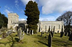
503:, many carved on both faces. Cherubs, death's heads and various mortality emblems abound."
489:
485:
405:, and extended 55 miles (89 km) northwards across Northumberland to the mouth of the
452:, with later additions including an 18th-century library wing added by Dr John Sharpe.
420:. This small woodland has been described as one of the best British woods for views. A
417:
367:
337:
128:
67:
499:, in the churchyard there is "the best collection in the county of well-preserved C18
677:
551:
352:
442:
429:
390:
406:
500:
449:
315:
302:
433:
402:
371:
363:
180:
394:
492:, who may have used the church in the 13th century, are still visible.
341:
162:
425:
458:
421:
344:. It is situated about 6 miles (10 km) to the west of
441:
520:
Office for
National Statistics: Neighbourhood Statistics
484:
The village church is the parish church of St Andrew, a
448:
The Old
Vicarage in Hartburn is at heart a Northumbrian
556:
The
Concise Oxford Dictionary of English Place-names
366:
river, which a couple of miles downstream joins the
255:
239:
227:
215:
201:
189:
179:
169:
155:
137:
119:
101:
85:
77:
23:
351:The place-name 'Hartburn' is first attested in
348:. The population at the 2011 census was 194.
8:
20:
569:"The 10 best woods and forests for views"
495:According to the architectural historian
512:
254:
210:
178:
154:
84:
27:
238:
226:
214:
200:
188:
168:
136:
118:
100:
7:
472:was designed by renowned architect
605:National Heritage List for England
370:, which flows through Morpeth and
14:
600:"Hartburn War Memorial (1042078)"
359:. The name means 'stag stream'.
53:
52:
45:
29:
532:"Civil Parish population 2011"
1:
355:of 1198, where it appears as
35:St. Andrew's Church, Hartburn
664:(Accessed: 21 November 2008)
432:. Near the grotto there are
583:The Caves of Northumberland
87:OS grid reference
18:Human settlement in England
700:
684:Villages in Northumberland
644:Keys to the past, Hartburn
273:
251:
211:
40:
28:
631:The Buildings of England
486:Grade I listed building
466:
393:road which started at
362:The village is on the
191:Postcode district
121:Ceremonial county
103:Unitary authority
81:194 (2011 census)
585:, Sigma Leisure, 2019
470:Hartburn War Memorial
464:Hartburn War Memorial
462:
626:Sir Nikolaus Pevsner
497:Sir Nikolaus Pevsner
424:, known as Hartburn
171:Sovereign state
312: /
467:
411:Berwick-upon-Tweed
257:UK Parliament
203:Dialling code
185:BERWICK UPON TWEED
665:
474:Sir Edwin Lutyens
331:
330:
691:
663:
636:
633:: Northumberland
623:
617:
616:
614:
612:
596:Historic England
592:
586:
579:
573:
572:
565:
559:
549:
543:
542:
540:
538:
528:
522:
517:
387:Devil's Causeway
336:is a village in
327:
326:
324:
323:
322:
317:
316:55.168°N 1.862°W
313:
310:
309:
308:
305:
279:
165:
97:
96:
66:Location within
56:
55:
49:
33:
21:
699:
698:
694:
693:
692:
690:
689:
688:
674:
673:
657:
640:
639:
624:
620:
610:
608:
594:
593:
589:
581:Scaife, Chris:
580:
576:
571:. 8 April 2011.
567:
566:
562:
550:
546:
536:
534:
530:
529:
525:
518:
514:
509:
490:Knights Templar
482:
480:Religious sites
383:
377:
320:
318:
314:
311:
306:
303:
301:
299:
298:
297:
277:
269:
161:
151:
133:
115:
92:
91:
73:
72:
71:
70:
64:
63:
62:
61:
57:
36:
19:
12:
11:
5:
697:
695:
687:
686:
676:
675:
672:
671:
666:
656:
655:External links
653:
652:
651:
646:
638:
637:
618:
587:
574:
560:
544:
523:
511:
510:
508:
505:
481:
478:
418:Woodland Trust
399:Hadrian's Wall
382:
379:
368:River Wansbeck
338:Northumberland
329:
328:
321:55.168; -1.862
296:
295:
293:Northumberland
290:
285:
280:
278:List of places
274:
271:
270:
268:
267:
261:
259:
253:
252:
249:
248:
243:
237:
236:
234:Northumberland
231:
225:
224:
219:
213:
212:
209:
208:
205:
199:
198:
193:
187:
186:
183:
177:
176:
175:United Kingdom
173:
167:
166:
159:
153:
152:
150:
149:
143:
141:
135:
134:
132:
131:
129:Northumberland
125:
123:
117:
116:
114:
113:
111:Northumberland
107:
105:
99:
98:
89:
83:
82:
79:
75:
74:
68:Northumberland
65:
59:
58:
51:
50:
44:
43:
42:
41:
38:
37:
34:
26:
25:
17:
13:
10:
9:
6:
4:
3:
2:
696:
685:
682:
681:
679:
670:
667:
662:
659:
658:
654:
650:
647:
645:
642:
641:
634:
632:
627:
622:
619:
607:
606:
601:
597:
591:
588:
584:
578:
575:
570:
564:
561:
557:
553:
552:Eilert Ekwall
548:
545:
533:
527:
524:
521:
516:
513:
506:
504:
502:
498:
493:
491:
487:
479:
477:
475:
471:
465:
461:
457:
453:
451:
446:
444:
438:
435:
431:
427:
423:
419:
414:
412:
408:
404:
400:
396:
392:
388:
380:
378:
375:
373:
369:
365:
360:
358:
354:
353:Charter Rolls
349:
347:
343:
339:
335:
325:
294:
291:
289:
286:
284:
281:
276:
275:
272:
266:
263:
262:
260:
258:
250:
247:
244:
242:
235:
232:
230:
223:
220:
218:
206:
204:
197:
194:
192:
184:
182:
174:
172:
164:
160:
158:
148:
145:
144:
142:
140:
130:
127:
126:
124:
122:
112:
109:
108:
106:
104:
95:
90:
88:
80:
76:
69:
48:
39:
32:
22:
16:
629:
621:
609:. Retrieved
603:
590:
582:
577:
563:
555:
547:
535:. Retrieved
526:
515:
494:
483:
468:
454:
447:
443:bastle house
439:
430:Adam and Eve
415:
384:
376:
374:to the sea.
361:
356:
350:
333:
332:
15:
611:4 September
407:River Tweed
401:, north of
319: /
222:Northumbria
537:29 January
507:References
501:headstones
450:pele tower
357:Herteburne
304:55°10′05″N
246:North East
147:North East
78:Population
649:NMC Guide
434:postholes
403:Corbridge
381:Landmarks
372:Ashington
364:Hart Burn
307:1°51′43″W
241:Ambulance
181:Post town
678:Category
635:, p.305.
558:, p.222.
395:Portgate
334:Hartburn
265:Wansbeck
94:NZ088860
60:Hartburn
24:Hartburn
346:Morpeth
342:England
288:England
163:England
157:Country
661:GENUKI
426:Grotto
217:Police
139:Region
391:Roman
340:, in
207:01670
613:2016
539:2016
422:cave
385:The
229:Fire
196:NE61
409:at
397:on
680::
628:,
602:.
598:.
554:,
445:.
413:.
283:UK
615:.
541:.
Text is available under the Creative Commons Attribution-ShareAlike License. Additional terms may apply.