37:
378:
244:. It was situated on the west side of the A697. There were a wide range of buildings (as well as the station building), namely a stone warehouse, coal and lime drops, an office and livestock loading facilities. As well as having these facilities, there were five sidings, one serving the goods shed and three serving a goods platform. In 1911, the station sold 4,279 tickets with the population of the local village being 1,252. The station closed to passengers on 22 September 1930 and to goods traffic on 2 March 1953.
419:
453:
448:
73:
443:
438:
111:
468:
412:
463:
405:
458:
343:
241:
148:
36:
158:
377:
105:
357:
225:
55:
331:
385:
266:
389:
348:
229:
59:
432:
284:
270:
88:
75:
263:
Railway passenger stations in
England, Scotland and Wales - a chronology
265:. Richmond: Railway and Canal Historical Society. p. 238.
393:
192:
184:
169:
164:
154:
144:
139:
131:
126:
118:
104:
67:
51:
46:
23:
16:
Disused railway station in
Ilderton, Northumberland
454:Railway stations in Great Britain closed in 1930
449:Railway stations in Great Britain opened in 1887
240:The station opened on 5 September 1887 by the
413:
8:
444:Former North Eastern Railway (UK) stations
439:Disused railway stations in Northumberland
420:
406:
35:
20:
469:North East England railway station stubs
310:
253:
384:This article on a railway station in
7:
374:
372:
228:, England from 1887 to 1953 on the
392:. You can help Knowledge (XXG) by
14:
464:1953 disestablishments in England
376:
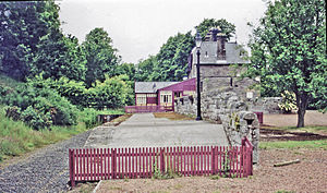
41:The site of the station in 2000
459:1887 establishments in England
1:
285:"Disused Stations: Ilderton"
485:
371:
170:5 September 1887
356:
342:
330:
215:
211:
207:
34:
226:Ilderton, Northumberland
222:Ilderton railway station
362:Line and station closed
336:Line and station closed
224:served the village of
193:2 March 1953
344:North Eastern Railway
242:North Eastern Railway
149:North Eastern Railway
188:Closed to passengers
261:Quick, M E (2002).
85: /
47:General information
386:North East England
326:Following station
314:Preceding station
89:55.5062°N 1.9711°W
401:
400:
367:
366:
363:
351:
337:
320:Disused railways
219:
218:
203:Closed completely
185:22 September 1930
127:Other information
476:
422:
415:
408:
380:
373:
361:
347:
335:
311:
300:
299:
297:
295:
289:Disused Stations
281:
275:
274:
258:
200:
198:
177:
175:
145:Original company
114:
100:
99:
97:
96:
95:
94:55.5062; -1.9711
90:
86:
83:
82:
81:
78:
39:
21:
484:
483:
479:
478:
477:
475:
474:
473:
429:
428:
427:
426:
369:
360:
349:Cornhill Branch
346:
334:
309:
304:
303:
293:
291:
283:
282:
278:
260:
259:
255:
250:
238:
230:Cornhill Branch
196:
194:
173:
171:
110:
93:
91:
87:
84:
79:
76:
74:
72:
71:
62:
42:
30:
29:
28:
17:
12:
11:
5:
482:
480:
472:
471:
466:
461:
456:
451:
446:
441:
431:
430:
425:
424:
417:
410:
402:
399:
398:
381:
365:
364:
355:
352:
341:
338:
328:
327:
324:
321:
318:
315:
308:
307:External links
305:
302:
301:
276:
252:
251:
249:
246:
237:
234:
217:
216:
213:
212:
209:
208:
205:
204:
201:
190:
189:
186:
182:
181:
178:
167:
166:
162:
161:
156:
152:
151:
146:
142:
141:
137:
136:
133:
129:
128:
124:
123:
120:
116:
115:
108:
106:Grid reference
102:
101:
69:
65:
64:
60:Northumberland
53:
49:
48:
44:
43:
40:
32:
31:
26:
25:
24:
15:
13:
10:
9:
6:
4:
3:
2:
481:
470:
467:
465:
462:
460:
457:
455:
452:
450:
447:
445:
442:
440:
437:
436:
434:
423:
418:
416:
411:
409:
404:
403:
397:
395:
391:
387:
382:
379:
375:
370:
359:
353:
350:
345:
339:
333:
329:
325:
322:
319:
316:
313:
312:
306:
290:
286:
280:
277:
272:
268:
264:
257:
254:
247:
245:
243:
235:
233:
231:
227:
223:
214:
210:
206:
202:
191:
187:
183:
179:
168:
163:
160:
157:
155:Post-grouping
153:
150:
147:
143:
138:
134:
130:
125:
121:
117:
113:
109:
107:
103:
98:
70:
66:
61:
57:
54:
50:
45:
38:
33:
22:
19:
394:expanding it
383:
368:
292:. Retrieved
288:
279:
262:
256:
239:
221:
220:
18:
92: /
68:Coordinates
433:Categories
248:References
197:1953-03-02
174:1887-09-05
77:55°30′22″N
358:Wooperton
271:931112387
165:Key dates
119:Platforms
80:1°58′16″W
112:NU019236
56:Ilderton
52:Location
27:Ilderton
354:
340:
323:
317:
294:7 March
236:History
195: (
172: (
140:History
135:Disused
63:England
332:Wooler
269:
180:Opened
132:Status
388:is a
390:stub
296:2018
267:OCLC
159:LNER
435::
287:.
232:.
58:,
421:e
414:t
407:v
396:.
298:.
273:.
199:)
176:)
122:1
Text is available under the Creative Commons Attribution-ShareAlike License. Additional terms may apply.