311:
29:
335:
323:
299:
280:
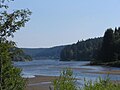
A quiet concrete road from Königshütte runs along the northern side of the reservoir as far as the dam. On the south side a wide footpath leads back to Königshütte, which passes the
269:
has a capacity of 1.2 million m³ and covers an area of 32 hectares. Part of the water is diverted from here through a 1,795 m long tunnel to the
254:
The gently curving dam wall is 108 m long and has a volume of 13,500 m³. It can be overtopped along almost its entire length. In one section there is a
378:
351:
51:
284:
of the Kalte and Warme Bode. Numerous footpaths lead from the dam in almost all directions of the compass. The location is suitable for both
310:
334:
408:
205:
398:
322:
298:
403:
227:
The dam itself was built on the Bode from 1939 to 1943 and 1952–1956 with construction being interrupted by the
356:
28:
274:
255:
248:
213:
270:
209:
251:. The power station has a nominal output of 60 kW and generates 0.18 GWh per annum.
383:
244:
228:
181:
39:
240:
197:
157:
392:
259:
193:
221:
201:
232:
289:
281:
66:
53:
285:
266:
277:, where it is reunited with the water from the Rappbode Reservoir again.
236:
247:. It also provides reserves of water during times of drought and
373:
189:
273:. The rest flows back into the Bode and down to the
166:
156:
148:
143:
135:
127:
119:
111:
103:
98:
90:
82:
45:
35:
21:
258:that can be lowered by 1.5 metres to provide
8:
27:
18:
216:). It is a so-called storage reservoir (
294:
352:List of reservoirs and dams in Germany
7:
384:Die Überleitungssperre Königshütte
14:
374:Talsperrenbetrieb Sachsen-Anhalt
333:
321:
309:
297:
231:. It is an 18 metre high
1:
425:
316:Approach from Königshütte
26:
357:List of dams in the Harz
212:(both in the borough of
200:. It impounds the River
192:in the German state of
83:Construction began
409:Dams completed in 1956
220:) forming part of the
185:
136:Spillway capacity
399:Dams in Saxony-Anhalt
379:Talsperre Königshütte
186:Talsperre Königshütte
67:51.73861°N 10.79333°E
340:East side of the dam
275:Wendefurth Reservoir
256:fish-belly flap gate
249:hydro-electric power
239:, for the supply of
214:Oberharz am Brocken
158:Catchment area
149:Total capacity
63: /
271:Rappbode Reservoir
218:Überleitungssperre
120:Width (crest)
72:51.73861; 10.79333
16:Dam in Harz county
204:and lies between
174:
173:
167:Surface area
99:Dam and spillways
91:Opening date
416:
404:Dams in the Harz
337:
325:
313:
301:
245:flood protection
78:
77:
75:
74:
73:
68:
64:
61:
60:
59:
56:
31:
19:
424:
423:
419:
418:
417:
415:
414:
413:
389:
388:
370:
365:
348:
341:
338:
329:
326:
317:
314:
305:
304:Western section
302:
178:Königshütte Dam
152:1.45 million m³
128:Dam volume
71:
69:
65:
62:
57:
54:
52:
50:
49:
22:Königshütte Dam
17:
12:
11:
5:
422:
420:
412:
411:
406:
401:
391:
390:
387:
386:
381:
376:
369:
368:External links
366:
364:
361:
360:
359:
354:
347:
344:
343:
342:
339:
332:
330:
327:
320:
318:
315:
308:
306:
303:
296:
241:drinking water
198:Harz mountains
172:
171:
168:
164:
163:
160:
154:
153:
150:
146:
145:
141:
140:
137:
133:
132:
129:
125:
124:
121:
117:
116:
113:
109:
108:
105:
101:
100:
96:
95:
92:
88:
87:
84:
80:
79:
47:
43:
42:
37:
33:
32:
24:
23:
15:
13:
10:
9:
6:
4:
3:
2:
421:
410:
407:
405:
402:
400:
397:
396:
394:
385:
382:
380:
377:
375:
372:
371:
367:
362:
358:
355:
353:
350:
349:
345:
336:
331:
324:
319:
312:
307:
300:
295:
293:
291:
287:
283:
278:
276:
272:
268:
263:
261:
260:flood control
257:
252:
250:
246:
242:
238:
234:
230:
225:
223:
219:
215:
211:
207:
203:
199:
195:
194:Saxony-Anhalt
191:
187:
183:
179:
169:
165:
161:
159:
155:
151:
147:
142:
138:
134:
130:
126:
122:
118:
114:
110:
106:
102:
97:
93:
89:
85:
81:
76:
48:
44:
41:
38:
34:
30:
25:
20:
279:
264:
253:
226:
222:Rappbode Dam
217:
177:
175:
233:gravity dam
206:Königshütte
70: /
46:Coordinates
40:Harz county
393:Categories
363:References
328:North side
282:confluence
235:, made of
139:258.7 m³/s
58:10°47′36″E
55:51°44′19″N
267:reservoir
210:Susenburg
144:Reservoir
131:13,500 m³
346:See also
243:and for
237:concrete
224:system.
162:154.2 km
36:Location
290:walkers
286:anglers
196:in the
188:) is a
182:German
112:Length
107:18.2 m
104:Height
170:32 ha
115:108 m
288:and
265:The
208:and
202:Bode
176:The
94:1956
86:1952
229:war
190:dam
123:7 m
395::
292:.
262:.
184::
180:(
Text is available under the Creative Commons Attribution-ShareAlike License. Additional terms may apply.