120:
811:
1032:
829:
347:
793:
783:
773:
104:
1078:
89:
64:
79:
708:
733:
981:
127:
685:
631:
in Gifu prefecture was created, and with the establishment of the modern municipalities system on July 1, 1889 the town of
Imawatari was created. On February 1, 1955, Imawatari merged with the villages of Dota, Katabira, Harusato, Kukuri, Hiromaki and Hiromi to form the town of Kani. On April 1,
672:
Kani has 11 public elementary schools and 5 public middle schools operated by the city government, and one private elementary and one private junior high school. The city has two public high schools operated by the Gifu
Prefectural Board of Education and one private high school. Both
427:). The average annual temperature in Kani is 15.0 °C. The average annual rainfall is 1984 mm with September as the wettest month. The temperatures are highest on average in August, at around 27.6 °C, and lowest in January, at around 3.2 °C.
411:
flows in the northern part of the city and roughly flat terrain continues to the Ota Basin on the opposite bank. The eastern portion of the city is hilly, and has many golf courses (golf courses occupy nearly 10% of the city area).
927:
119:
151:
1031:
17:
103:
1401:
1377:
678:
963:
407:
Kani is located in the south-central Gifu
Prefecture, about 30 km from either Gifu city or Nagoya city, in the Kani basin. The
421:
399:
of 1100 persons per km, in 42,286 households. The total area of the city was 87.57 square kilometres (33.81 sq mi).
1021:
937:
1077:
749:
999:
689:
88:
1352:
1049:
1359:
810:
796:
195:
183:
63:
786:
776:
1306:
1291:
1242:
1203:
346:
985:
1335:
757:
489:
Per
Japanese census data, the population of Kani has recently plateaued after a period of rapid growth.
1347:
78:
1059:
736:
207:
1396:
1323:
1281:
1225:
628:
294:
275:
420:
The city has a climate characterized by characterized by hot and humid summers, and mild winters (
1259:
1014:
741:
604:
396:
820:
753:
720:
661:
624:
1286:
1230:
745:
674:
471:
1364:
1252:
1035:
959:
384:
380:
212:
54:
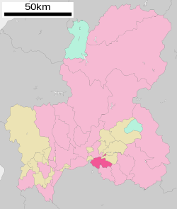
200:
1340:
1301:
1218:
1187:
1177:
1147:
1137:
664:
for Gifu and Nagoya. Local industry is dominated by manufacturers of automobile parts.
633:
476:
459:
444:
304:
25:
1390:
1213:
1208:
1107:
1102:
1007:
816:
645:
586:
1328:
1316:
1311:
1296:
1152:
1142:
1122:
915:
834:
732:
724:
594:
464:
454:
439:
1274:
608:
1269:
1247:
1235:
1157:
863:
707:
361:
904:
1182:
1167:
1132:
1112:
1097:
838:
715:
711:
649:
590:
449:
408:
392:
166:
153:
1092:
842:
828:
266:
599:
980:
1162:
660:
The population of Kani has increased rapidly over the past 40 years as a
1264:
620:
364:
1172:
271:
1117:
632:
1982 Kani was raised to city status. On May 1, 2005, the town of
616:
388:
345:
188:
1067:
1044:
506:
308:
21:
1003:
991:
612:
336:
966:). Embassy of Brazil in Tokyo. Retrieved on October 13, 2015.
890:
501:
391:. As of 1 April 2024, the city had an estimated
648:
form of government with a directly elected mayor and a
1196:
1085:
1058:
330:
322:
314:
300:
290:
282:
265:
257:
249:
244:
236:
231:
223:
218:
206:
194:
182:
36:
636:(also from Kani District) was merged into Kani.
370:
593:, the area was divided between the holding of
359:
42:
1015:
585:The area around Kani was part of traditional
8:
692:is an international school located in Kani.
684:The Sociedade Educacional Brazilian School (
492:
1022:
1008:
1000:
623:located in what is now Kani. In the post-
491:
33:
960:Escolas Brasileiras Homologadas no Japão
855:
329:
326:Hiromi 1-1, Kani-shi, Gifu-ken 509-0292
313:
281:
264:
243:
230:
217:
181:
146:
112:
100:
72:
60:
619:passed through the area, with several
603:territory under direct control of the
321:
299:
289:
256:
248:
240:87.57 km (33.81 sq mi)
235:
222:
205:
193:
7:
108:Location of Kani in Gifu Prefecture
1378:List of mergers in Gifu Prefecture
679:Gifu University of Medical Science
350:Flower Festival Commemorative Park
14:
1076:
1030:
979:
827:
809:
791:
781:
771:
731:
706:
652:city legislature of 22 members.
125:
118:
102:
87:
77:
62:
1:
936:(in Japanese). Archived from
891:Kani city official statistics
422:Köppen climate classification
126:
431:Neighbouring municipalities
371:
261:1,100/km (3,000/sq mi)
1418:
992:Kani City official website
916:Kani population statistics
686:ソシエダーデ・エドカショナル・ブラジリアン・スクール
15:
1402:Cities in Gifu Prefecture
1375:
1074:
1042:
519:—
360:
147:
113:
101:
73:
61:
52:
43:
928:
864:
167:35.426056°N 137.061333°E
40:
18:sushi/sashimi ingredient
797:National Route 248
681:have a campus in Kani.
787:National Route 41
777:National Route 21
351:
934:Kani official website
870:Kani official website
845:, since November 2015
803:Sister city relations
493:Historical population
349:
172:35.426056; 137.061333
988:at Wikimedia Commons
737:Meitetsu Hiromi Line
258: • Density
31:City in Chūbu, Japan
750:Nihonrain-imawatari
627:cadastral reforms,
611:highway connecting
494:
295:Japanese black pine
276:Japan Standard Time
163: /
940:on October 3, 2011
605:Tokugawa shogunate
397:population density
352:
250: • Total
237: • Total
224: • Mayor
1384:
1383:
1053:
984:Media related to
905:Kani climate data
821:Northern Marianas
662:bedroom community
625:Meiji restoration
578:
577:
344:
343:
315:Phone number
1409:
1292:Higashishirakawa
1243:Hashima District
1204:Anpachi District
1080:
1047:
1034:
1024:
1017:
1010:
1001:
996:
983:
967:
956:
950:
949:
947:
945:
924:
918:
913:
907:
902:
896:
895:
888:
882:
881:
879:
877:
860:
832:
831:
814:
813:
795:
794:
785:
784:
775:
774:
735:
710:
690:Brazilian school
675:Meijo University
508:
503:
495:
472:Aichi Prefecture
436:Gifu Prefecture
395:of 99,826 and a
378:
377:
374:
368:
367:
340:
339:
337:Official website
178:
177:
175:
174:
173:
168:
164:
161:
160:
159:
156:
129:
128:
122:
106:
91:
81:
66:
47:
46:
45:
34:
1417:
1416:
1412:
1411:
1410:
1408:
1407:
1406:
1387:
1386:
1385:
1380:
1371:
1336:Motosu District
1192:
1081:
1072:
1054:
1038:
1036:Gifu Prefecture
1028:
994:
976:
971:
970:
957:
953:
943:
941:
930:
926:
925:
921:
914:
910:
903:
899:
893:
889:
885:
875:
873:
866:
862:
861:
857:
852:
826:
808:
805:
792:
782:
772:
768:
703:
698:
670:
658:
642:
583:
487:
433:
418:
405:
375:
357:
335:
334:
171:
169:
165:
162:
157:
154:
152:
150:
149:
143:
142:
141:
140:
137:
136:
135:
134:
130:
109:
97:
96:
95:
94:
85:
84:
69:
57:
48:
41:
39:
32:
29:
12:
11:
5:
1415:
1413:
1405:
1404:
1399:
1389:
1388:
1382:
1381:
1376:
1373:
1372:
1370:
1369:
1368:
1367:
1357:
1356:
1355:
1345:
1344:
1343:
1333:
1332:
1331:
1321:
1320:
1319:
1314:
1309:
1304:
1299:
1294:
1289:
1279:
1278:
1277:
1272:
1267:
1257:
1256:
1255:
1250:
1240:
1239:
1238:
1233:
1223:
1222:
1221:
1216:
1211:
1200:
1198:
1194:
1193:
1191:
1190:
1185:
1180:
1175:
1170:
1165:
1160:
1155:
1150:
1145:
1140:
1135:
1130:
1125:
1120:
1115:
1110:
1105:
1100:
1095:
1089:
1087:
1083:
1082:
1075:
1073:
1071:
1070:
1064:
1062:
1056:
1055:
1043:
1040:
1039:
1029:
1027:
1026:
1019:
1012:
1004:
998:
997:
989:
975:
974:External links
972:
969:
968:
951:
919:
908:
897:
883:
854:
853:
851:
848:
847:
846:
824:
804:
801:
800:
799:
789:
779:
767:
764:
763:
762:
761:
760:
729:
728:
727:
702:
699:
697:
696:Transportation
694:
669:
666:
657:
654:
641:
638:
589:. During the
582:
579:
576:
575:
572:
569:
565:
564:
561:
558:
554:
553:
550:
547:
543:
542:
539:
536:
532:
531:
528:
525:
521:
520:
517:
514:
510:
509:
504:
499:
486:
483:
482:
481:
480:
479:
469:
468:
467:
462:
457:
452:
447:
442:
432:
429:
417:
414:
404:
401:
342:
341:
332:
328:
327:
324:
320:
319:
316:
312:
311:
305:Satsuki azalea
302:
298:
297:
292:
288:
287:
284:
280:
279:
269:
263:
262:
259:
255:
254:
251:
247:
246:
242:
241:
238:
234:
233:
229:
228:
227:Shigeki Tomida
225:
221:
220:
216:
215:
210:
204:
203:
198:
192:
191:
186:
180:
179:
145:
144:
138:
132:
131:
124:
123:
117:
116:
115:
114:
111:
110:
107:
99:
98:
92:
86:
82:
76:
75:
74:
71:
70:
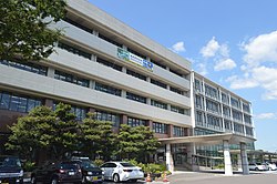
68:Kani City Hall
67:
59:
58:
53:
50:
49:
37:
30:
26:imitation crab
13:
10:
9:
6:
4:
3:
2:
1414:
1403:
1400:
1398:
1395:
1394:
1392:
1379:
1374:
1366:
1363:
1362:
1361:
1360:Yōrō District
1358:
1354:
1351:
1350:
1349:
1346:
1342:
1339:
1338:
1337:
1334:
1330:
1327:
1326:
1325:
1324:Kani District
1322:
1318:
1315:
1313:
1310:
1308:
1305:
1303:
1300:
1298:
1295:
1293:
1290:
1288:
1285:
1284:
1283:
1282:Kamo District
1280:
1276:
1273:
1271:
1268:
1266:
1263:
1262:
1261:
1258:
1254:
1251:
1249:
1246:
1245:
1244:
1241:
1237:
1234:
1232:
1229:
1228:
1227:
1226:Fuwa District
1224:
1220:
1217:
1215:
1212:
1210:
1207:
1206:
1205:
1202:
1201:
1199:
1195:
1189:
1186:
1184:
1181:
1179:
1176:
1174:
1171:
1169:
1166:
1164:
1161:
1159:
1156:
1154:
1151:
1149:
1146:
1144:
1141:
1139:
1136:
1134:
1131:
1129:
1126:
1124:
1121:
1119:
1116:
1114:
1111:
1109:
1106:
1104:
1101:
1099:
1096:
1094:
1091:
1090:
1088:
1084:
1079:
1069:
1066:
1065:
1063:
1061:
1057:
1051:
1046:
1041:
1037:
1033:
1025:
1020:
1018:
1013:
1011:
1006:
1005:
1002:
995:(in Japanese)
993:
990:
987:
982:
978:
977:
973:
965:
961:
955:
952:
939:
935:
931:
923:
920:
917:
912:
909:
906:
901:
898:
894:(in Japanese)
892:
887:
884:
872:(in Japanese)
871:
867:
859:
856:
849:
844:
840:
836:
830:
825:
822:
818:
812:
807:
806:
802:
798:
790:
788:
780:
778:
770:
769:
765:
759:
755:
751:
747:
743:
740:
739:
738:
734:
730:
726:
722:
719:
718:
717:
713:
709:
705:
704:
700:
695:
693:
691:
687:
682:
680:
676:
667:
665:
663:
655:
653:
651:
647:
646:mayor-council
639:
637:
635:
630:
629:Kani District
626:
622:
621:post stations
618:
614:
610:
606:
602:
601:
596:
592:
588:
587:Mino Province
580:
573:
570:
567:
566:
562:
559:
556:
555:
551:
548:
545:
544:
540:
537:
534:
533:
529:
526:
523:
522:
518:
515:
512:
511:
505:
500:
497:
496:
490:
484:
478:
475:
474:
473:
470:
466:
463:
461:
458:
456:
453:
451:
448:
446:
443:
441:
438:
437:
435:
434:
430:
428:
426:
423:
415:
413:
410:
402:
400:
398:
394:
390:
386:
382:
373:
366:
363:
356:
348:
338:
333:
325:
317:
310:
306:
303:
296:
293:
285:
277:
273:
270:
268:
260:
252:
239:
226:
214:
211:
209:
202:
199:
197:
190:
187:
185:
176:
158:137°03′40.8″E
148:Coordinates:
121:
105:
90:
80:
65:
56:
51:
35:
27:
23:
19:
1348:Ōno District
1260:Ibi District
1127:
1123:Kakamigahara
954:
942:. Retrieved
938:the original
933:
922:
911:
900:
886:
874:. Retrieved
869:
858:
835:Redland City
823:, since 1995
683:
671:
659:
643:
598:
595:Owari Domain
584:
488:
485:Demographics
424:
419:
406:
354:
353:
318:0574-62-1111
283:City symbols
155:35°25′33.8″N
1158:Nakatsugawa
644:Kani has a
383:located in
170: /
1397:Kani, Gifu
1391:Categories
1231:Sekigahara
986:Kani, Gifu
944:August 11,
876:August 11,
850:References
839:Queensland
742:Nishi Kani
716:Taita Line
712:JR Central
650:unicameral
640:Government
591:Edo period
409:Kiso River
393:population
245:Population
219:Government
208:Prefecture
1353:Shirakawa
1307:Shirakawa
1253:Kasamatsu
1197:Districts
1060:Core city
843:Australia
754:Shin Kani
721:Shimogiri
668:Education
609:Nakasendō
403:Geography
267:Time zone
1341:Kitagata
1302:Sakahogi
1219:Wanouchi
1188:Yamagata
1178:Takayama
1148:Mizunami
1138:Minokamo
746:Kanigawa
677:and the
634:Kaneyama
460:Sakahogi
445:Minokamo
372:Kani-shi
301:- Flower
16:For the
1287:Hichisō
1265:Ibigawa
1209:Anpachi
1108:Hashima
1050:capital
964:Archive
865:市長の部屋から
766:Highway
701:Railway
656:Economy
581:History
477:Inuyama
416:Climate
331:Website
323:Address
184:Country
1329:Mitake
1317:Yaotsu
1312:Tomika
1297:Kawabe
1173:Tajimi
1153:Motosu
1143:Mizuho
1086:Cities
929:可児市の概要
758:Akechi
607:. The
600:tenryō
571:99,968
560:97,436
552:+14.0%
549:93,463
541:+43.1%
538:81,968
530:+88.5%
527:57,290
516:30,390
465:Mitake
455:Yaotsu
440:Tajimi
291:- Tree
286:
253:99,826
196:Region
139:
20:, see
1270:Ikeda
1248:Ginan
1236:Tarui
1163:Ōgaki
1118:Kaizu
617:Kyoto
574:+2.6%
568:2020
563:+4.3%
557:2010
546:2000
535:1990
524:1980
513:1970
389:Japan
379:is a
272:UTC+9
201:Chūbu
189:Japan
1365:Yōrō
1214:Gōdo
1183:Toki
1168:Seki
1133:Mino
1128:Kani
1113:Hida
1103:Gujō
1098:Gero
1068:Gifu
1045:Gifu
946:2011
878:2011
817:Rota
725:Kani
688:) -
615:and
597:and
502:Pop.
498:Year
450:Toki
385:Gifu
381:city
355:Kani
309:rose
307:and
232:Area
213:Gifu
133:Kani
93:Seal
83:Flag
55:City
38:Kani
24:and
22:crab
1275:Ōno
1093:Ena
962:" (
752:-
723:-
714:-
613:Edo
425:Cfa
44:可児市
1393::
932:.
868:.
841:,
837:,
833:-
819:,
815:-
756:-
748:-
744:-
507:±%
387:,
369:,
362:可児
1052:)
1048:(
1023:e
1016:t
1009:v
958:"
948:.
880:.
376:)
365:市
358:(
278:)
274:(
28:.
Text is available under the Creative Commons Attribution-ShareAlike License. Additional terms may apply.