50:
83:
374:
476:
156:
90:
57:
510:
Holy Family Higher
Secondary School and Nazareth LP & U.P. School are the major educational institutions (are aided) in this village and students from nearby places also depend on these schools for their formal and secondary education. Other than these institutions there are preliminary schools,
519:
The
Kattipara Gram Panchayath is the major government institution in this locality which has Thamarassery, Poonor, Puthupadi and Thalayad as its borders. Other institutions include Kattipara Veterinary Hospital, Government Homeo Dispensory,Government Ayurveda Dispensory,Public Health Centre(PHC),
427:
The major source of income in this village is agriculture. Majority of the population depend on the agriculture crops such as rubber, coconut, arecanut, ginger, pepper etc. A very minority only depend on business and government jobs. There are many self-help groups, small scale industries and a
436:
The major tourist places in this village are
Kualamala and Amaradu Mala which are good for trekking and sightseeing. Wild animals like monkeys, deers, wild pigs, wild buffaloes and a large variety of insects and birds are found in the innermost forest area of both Kulamala and Amarad.
445:
Kattippara has a generally cool humid climate with a very hot season extending from March to May. The average annual rainfall is more than 3500 mm and it is the highest rain fall in this region.
400:
town. It is a village with a lot of hilly areas. As the name indicates, it is famous for hard rocks which we can find everywhere in this village. The adjacent villages are
Thalayad,
416:
The name 'Kattipara' was formed from hard rocks which were used by the early occupants of this area and the people who came from other places for agriculture and other people.
419:
The early occupants of
Kattipara were tribals. then different migrants from different religions came in the 1940s they set up houses and started different agriculture.
636:
428:
kudumba shree units active in this place. Other major sources of the people are products of agriculture, daily wagers, constructions and other businesses.
866:
118:
49:
629:
363:
168:
700:
82:
622:
861:
180:
358:
286:
198:
294:
705:
646:
389:
266:
185:
577:
695:
597:
353:
270:
780:
735:
373:
306:
614:
795:
690:
660:
573:
385:
475:
855:
820:
745:
840:
830:
825:
533:
397:
342:
720:
790:
557:
454:
133:
120:
815:
775:
750:
740:
725:
675:
670:
569:
541:
537:
331:
282:
277:
520:
Akshaya e kendra, branches of various banks,ATM,Bharat
Petroleum pump etc.
835:
810:
805:
785:
765:
685:
561:
560:. The eastern National Highway No.54 going through Adivaram connects to
405:
800:
755:
710:
680:
665:
529:
770:
760:
730:
715:
565:
553:
549:
462:
401:
393:
316:
173:
458:
372:
161:
312:
618:
545:
470:
528:
Kattippara village connects to other parts of India through
536:
town on the east. National highway No.66 passes through
384:(Hard Rock in Malayalam) often called as Kattipara, is a
486:
653:
352:
341:
330:
322:
305:
293:
276:
262:
257:
249:
241:
236:
228:
223:
215:
207:
196:
191:
179:
167:
149:
23:
580:. The nearest railway station is at Kozhikode.
630:
8:
637:
623:
615:
20:
408:, Unnikulam, Puthupadi and Thamarassery.
589:
292:
275:
256:
235:
222:
190:
148:
113:
41:
396:. It is located about 10 km from
540:and the northern stretch connects to
351:
340:
329:
321:
304:
261:
248:
240:
227:
214:
206:
195:
178:
166:
7:
552:. The southern stretch connects to
232:21.29 km (8.22 sq mi)
89:
56:
14:
216: • Panchayath President
474:
154:
88:
81:
55:
48:
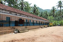
468:Nazareth LP School, Kattippara
572:. The nearest airports are at
453:Population consists of mainly
1:
867:Panchayats in Koduvally Block
208: • MLA (Koduvally)
253:1,400/km (3,700/sq mi)
883:
114:
69:Location in Kerala, India
42:
35:
506:Educational institutions
27:
515:Government Institutions
483:This section is empty.
378:
532:city on the west and
511:KGs and anganavadis.
376:
263: • Official
134:11.36111°N 76.00972°E
18:Town in Kerala, India
645:Cities and towns in
250: • Density
199:Member of Parliament
598:"gloriousindia.com"
130: /
647:Kozhikode district
390:Kozhikode district
379:
377:Nirmala U.P.School
242: • Total
229: • Total
139:11.36111; 76.00972
102:Kattippara (India)
72:Show map of Kerala
862:Thamarassery area
849:
848:
503:
502:
371:
370:
367:
105:Show map of India
874:
696:Chathangottunada
639:
632:
625:
616:
609:
608:
606:
604:
594:
498:
495:
485:You can help by
478:
471:
361:
160:
158:
157:
145:
144:
142:
141:
140:
135:
131:
128:
127:
126:
123:
106:
92:
91:
85:
73:
59:
58:
52:
21:
882:
881:
877:
876:
875:
873:
872:
871:
852:
851:
850:
845:
781:Njeliyanparambu
736:Karuvanthuruthy
649:
643:
613:
612:
602:
600:
596:
595:
591:
586:
526:
517:
508:
499:
493:
490:
451:
443:
434:
425:
420:
414:
301:
155:
153:
138:
136:
132:
129:
124:
121:
119:
117:
116:
110:
109:
108:
107:
104:
103:
100:
99:
98:
97:
93:
76:
75:
74:
71:
70:
67:
66:
65:
64:
60:
38:
31:
26:
19:
12:
11:
5:
880:
878:
870:
869:
864:
854:
853:
847:
846:
844:
843:
838:
833:
828:
823:
818:
813:
808:
803:
798:
796:Pantheeramkavu
793:
788:
783:
778:
773:
768:
763:
758:
753:
748:
743:
738:
733:
728:
723:
718:
713:
708:
703:
698:
693:
691:Chathamangalam
688:
683:
678:
673:
668:
663:
657:
655:
651:
650:
644:
642:
641:
634:
627:
619:
611:
610:
588:
587:
585:
582:
525:
524:Transportation
522:
516:
513:
507:
504:
501:
500:
481:
479:
450:
447:
442:
439:
433:
430:
424:
421:
418:
413:
410:
369:
368:
356:
350:
349:
346:
339:
338:
335:
328:
327:
324:
320:
319:
309:
303:
302:
299:
297:
291:
290:
280:
274:
273:
264:
260:
259:
255:
254:
251:
247:
246:
243:
239:
238:
234:
233:
230:
226:
225:
221:
220:
217:
213:
212:
209:
205:
204:
201:
194:
193:
189:
188:
183:
177:
176:
171:
165:
164:
151:
147:
146:
112:
111:
101:
95:
94:
87:
86:
80:
79:
78:
77:
68:
62:
61:
54:
53:
47:
46:
45:
44:
43:
40:
39:
36:
33:
32:
24:
17:
13:
10:
9:
6:
4:
3:
2:
879:
868:
865:
863:
860:
859:
857:
842:
839:
837:
834:
832:
829:
827:
824:
822:
821:Ramanattukara
819:
817:
814:
812:
809:
807:
804:
802:
799:
797:
794:
792:
789:
787:
784:
782:
779:
777:
774:
772:
769:
767:
764:
762:
759:
757:
754:
752:
749:
747:
746:Kunnamangalam
744:
742:
739:
737:
734:
732:
729:
727:
724:
722:
719:
717:
714:
712:
709:
707:
704:
702:
699:
697:
694:
692:
689:
687:
684:
682:
679:
677:
674:
672:
669:
667:
664:
662:
659:
658:
656:
652:
648:
640:
635:
633:
628:
626:
621:
620:
617:
599:
593:
590:
583:
581:
579:
575:
571:
567:
563:
559:
555:
551:
547:
543:
539:
535:
531:
523:
521:
514:
512:
505:
497:
494:February 2013
488:
484:
480:
477:
473:
472:
469:
466:
465:communities.
464:
460:
456:
448:
446:
440:
438:
431:
429:
422:
417:
411:
409:
407:
403:
399:
395:
391:
387:
383:
375:
365:
360:
357:
355:
347:
344:
336:
333:
325:
318:
314:
310:
308:
298:
296:
288:
284:
281:
279:
272:
268:
265:
252:
244:
231:
218:
210:
202:
200:
197: •
187:
184:
182:
175:
172:
170:
163:
152:
143:
115:Coordinates:
84:
51:
34:
30:
22:
16:
841:Villiappally
831:Thiruvambadi
826:Thamarassery
601:. Retrieved
592:
534:Thamarassery
527:
518:
509:
491:
487:adding to it
482:
467:
452:
449:Demographics
444:
435:
426:
415:
398:Thamarassery
381:
380:
345:constituency
343:Vidhan Sabha
334:constituency
219:Premji James
203:M K Raghavan
28:
15:
721:Karaparamba
701:Cheruvannur
137: /
856:Categories
791:Orkkatteri
584:References
558:Trivandrum
382:Kattippara
311:1000:1040
237:Population
192:Government
122:11°21′40″N
96:Kattippara
63:Kattippara
29:Kattippara
25:Kattippara
776:Nadapuram
751:Kuttiyadi
741:Koduvally
726:Kadalundi
671:Balussery
654:Kozhikode
578:Kozhikode
570:Bangalore
542:Mangalore
538:Kozhikode
455:Christian
386:Panchayat
348:Koduvally
337:Kozhikode
332:Lok Sabha
307:Sex ratio
278:Time zone
267:Malayalam
258:Languages
211:MK Muneer
186:Kozhikode
125:76°0′35″E
836:Vatakara
816:Quilandy
811:Purameri
806:Perambra
786:Olavanna
766:Meppayur
686:Edacheri
562:Kalpetta
406:Kolikkal
359:pleasant
323:Literacy
283:UTC+5:30
181:District
801:Payyoli
756:Maniyur
711:Eramala
706:Elathur
681:Chorode
676:Calicut
666:Beypore
530:Calicut
441:Climate
432:Tourism
423:Economy
412:History
354:Climate
271:English
150:Country
771:Mukkam
761:Mavoor
731:Kappad
716:Feroke
661:Atholi
574:Kannur
566:Mysore
554:Cochin
550:Mumbai
463:Muslim
402:Chamal
394:Kerala
364:Köppen
300:673573
245:30,123
174:Kerala
159:
603:2 May
459:Hindu
169:State
162:India
605:2010
576:and
568:and
556:and
548:and
461:and
388:in
224:Area
37:Town
546:Goa
489:.
326:88%
295:PIN
287:IST
858::
564:,
544:,
457:,
404:,
392:,
269:,
638:e
631:t
624:v
607:.
496:)
492:(
366:)
362:(
317:♀
315:/
313:♂
289:)
285:(
Text is available under the Creative Commons Attribution-ShareAlike License. Additional terms may apply.