79:. It is about 6 miles (9.7 km) long by 2.5 miles (4.0 km), with the long axis being in the north-south direction, comprising a productive surface area of 5,495 acres (22.24 km). Elevations vary from approximately 500 to 1,000 feet (150 to 300 m) above sea level. The field is spread out, especially compared to the exceedingly dense development in the adjacent Kern River Oil Field, which has one of the densest oil developments in the United States, with over 9,000 oil wells clustered in just several square miles. The Kern Front Field is bounded on the west by
43:. Discovered in 1912, and with a cumulative production of around 210 million barrels (33,000,000 m) of oil, it ranks 29th in size in the state, and is believed to retain approximately ten percent of its original oil (approximately 22 million barrels (3,500,000 m)), according to the official estimates of the California Department of Oil, Gas, and Geothermal Resources (DOGGR). It is adjacent to the much larger
103:
20:
60:
94:. The climate is hot and arid, with summertime temperatures routinely exceeding 100 °F (38 °C); the mean freeze-free period runs from about 250 to 300 days. Mean annual precipitation is around 10 inches (250 mm), almost all as rain and almost all in the winter; summers are characteristically rainless.
163:
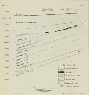
The average depth of the oil bearing units is about 2,300 feet (700 m), and the thickness of the oil-bearing strata ranges from 100 to 700 feet (30 to 213 m). Since the depth of the oil is relatively shallow, the temperature is relatively low, at only 100 °F (38 °C) (many of the
136:
on that side; on the northeast, the up-dip side of the field, the sands grade into relatively impermeable silts and clays, providing a seal in that direction. Many small southwest-trending faults run across the field. The
California DOGGR recognizes only one producing pool – the Etchegoin-Chanac –
217:
Current operators include
Bellaire, Vintage, E&B Natural Resource Management, West American Energy Corp., and a few others. The field operators deliver some wastewater from oil production to Valley Waste Disposal, with some wastewater being filtered and softened to make feedwater for steam
126:
marine sand, and the Chanac is a
Pliocene non-marine sand. Each is interbedded with silts and clays, and the sands have a high porosity, ranging from 25-33 percent, making them singularly suitable as petroleum reservoirs. Overlying the Etchegoin and Chanac formations is the
190:
began steam flooding in the southern portion of the field, and
Century Oil Management did the same in the northern portion. Petro-Lewis Corporation tested steam foam solution and a steam foam encapsulated in a polymer gel to see if steamflood performance could be improved.
408:
164:
deeper zones in
Central Valley oil fields produce oil over 200 °F (93 °C), a greater safety hazard to workers). In 1983, the date of DOGGR's data compilation, the water table in the field was at 2,500 feet (760 m) below ground surface.
230:. Vol. I (1998), Vol. II (1992), Vol. III (1982). California Department of Conservation, Division of Oil, Gas, and Geothermal Resources (DOGGR). 1,472 pp. McKittrick Oil Field information pp. 268-272. PDF file available on CD from www.consrv.ca.gov.
340:
NORTH KERN FRONT FIELD STEAM DRIVE WITH ANCILLARY MATERIALS, by Eson, Rodney L., Fitch, Jon P., Chemical Oil
Recovery Company; Shannon, Albert M., Petro-Lewis Corporation. In SPE/DOE Enhanced Oil Recovery Symposium, 5-8 April 1981, Tulsa,
197:
One of the current operators, Tearlach
Resources, has claimed that the field may actually contain a potential reserve of 500 million barrels (79,000,000 m). This estimate is based on work done by the operators of the field in 1990,
213:
As of the beginning of 2009, there were 838 producing oil wells on the field. If some of the current proposals for further exploration and development are enacted, such as those by
Tearlach, this number could increase considerably.
131:
Kern River
Formation, which is highly productive in the adjacent Kern River Oil Field. These units all have a northwest strike and a small southwest dip. A large north-trending fault on the east side of the field provides a
140:
Many sedimentary units underlie these petroleum-bearing sands, but they either have not produced much oil or have not been completely explored. Basement rocks – the granitic complex representing the huge
186:
method in the 1960s. Cyclic steam injection (the "huff and puff method" began in 1964, and production again rose, as the heavy oil flowed more freely to pumping wells. In 1978, former operator
160:
averaging 14, and a sulfur content of 0.9 percent by weight. Since this oil is heavy, it is viscous and flows easily only when assisted by steam injection or other enhanced recovery techniques.
210:, and involves both recovering previously uneconomic deposits, as well as exploring deeper, previously unexplored zones, which some of the geologists believed may be petroleum-bearing.
439:
478:
175:
discovered the field in 1912 with the drilling of their Well No. 1, into the
Etchegoin pool, to a depth of 2,836 feet (864 m). The well still exists, as
218:
boilers. Valley Waste skims residual oil and grease from the water, and the water is conveyed to Cawelo Water District, where it is re-used for irrigation.
383:
372:
257:
428:
179:
Well No. 1. Peak production for the field was in 1929, during which 4,535,029 barrels (721,012.0 m) of oil were pumped from the ground.
83:, on the southwest by James Road, and on the southeast by Bakersfield-Glennville Road. Oilfields Road runs south to north through the field.
429:
Public Notice Concerning Intent to Issue a Time Schedule Order, California Regional Water Quality Control Board, Central Valley Region.
270:
183:
90:
known as the Hardpan Terraces, at an elevation of less than 1,000 feet (300 m), the predominant native vegetation is
339:
360:
149:
age – occur at a depth of approximately 7,000 feet (2,100 m). The deepest well on the Kern Front Field, the
87:
80:
142:
72:
40:
36:
119:
153:"Kramer No. 1", reached a depth of 7,738 feet (2,359 m) before bumping into the basement complex.
207:
48:
44:
176:
172:
111:
68:
32:
239:
Bellaire Oil Company: description of geology, production, and operations at the Kern Front Field
133:
76:
238:
234:
California Department of Conservation, Oil and Gas Statistics, Annual Report, December 31, 2006.
102:
258:
California Department of Conservation, Oil and Gas Statistics, Annual Report, December 31, 2006
115:
23:
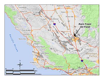
The Kern Front Oil Field in Kern County, California. Other oil fields are shown in gray.
274:
472:
187:
67:
The Kern Front Field is approximately 5 miles (8.0 km) due north of the city of
157:
128:
91:
19:
16:
Oil and gas field in the Sierra Nevada foothills in Kern County, California, USA
59:
454:
441:
382:. California Department of Conservation ("DOGGR 2009"). 2009. Archived from
146:
123:
182:
Production steadily declined from that peak until the invention of the
199:
58:
18:
203:
150:
75:, in the first gentle rise of the hills above the floor of the
110:
The Kern Front Field contains two major producing units, the
228:
California Oil and Gas Fields, Volumes I, II and III
63:
Oil wells and disturbed area on the Kern Front Field
373:"2008 Report of the state oil & gas supervisor"
380:Department of Oil, Gas, and Geothermal Resources
86:Being within the ecological subsection of the
8:
194:Gas production on the field peaked in 1980.
156:Oil from the field is heavy crude, with an
271:"Hardpan Terraces subregion description"
101:
250:
479:Oil fields in Kern County, California
273:. U.S. Forest Service. Archived from
71:, and 10 miles (16 km) north of
47:, which is to the southeast, and the
7:
409:California DOGGR database query page
137:and commingles the production data.
168:History, production, and operations
173:Standard Oil Company of California
106:Kern Front Oil Field Structure Map
14:
303:Bellaire oil: Kern Front Geology
122:overlain. The Etchegoin is a
1:
361:News release, 20 April 2007
495:
151:Atlantic Richfield Company
88:California Central Valley
81:California State Route 65
118:, both sedimentary, but
145:, and probably of late
143:Sierra Nevada batholith
41:Kern County, California
37:Sierra Nevada foothills
107:
64:
24:
105:
62:
22:
455:35.4844°N 119.0403°W
49:Mount Poso Oil Field
45:Kern River Oil Field
29:Kern Front Oil Field
451: /
112:Etchegoin Formation
460:35.4844; -119.0403
108:
77:San Joaquin Valley
65:
25:
294:DOGGR, p. 230-231
33:oil and gas field
486:
466:
465:
463:
462:
461:
456:
452:
449:
448:
447:
444:
431:
426:
420:
417:
411:
406:
400:
398:
396:
394:
388:
377:
369:
363:
358:
352:
349:
343:
337:
331:
328:
322:
319:
313:
310:
304:
301:
295:
292:
286:
285:
283:
282:
267:
261:
255:
494:
493:
489:
488:
487:
485:
484:
483:
469:
468:
459:
457:
453:
450:
445:
442:
440:
438:
437:
435:
434:
427:
423:
418:
414:
407:
403:
392:
390:
386:
375:
371:
370:
366:
359:
355:
350:
346:
338:
334:
329:
325:
320:
316:
311:
307:
302:
298:
293:
289:
280:
278:
269:
268:
264:
256:
252:
247:
224:
184:steam injection
170:
134:structural seal
100:
57:
17:
12:
11:
5:
492:
490:
482:
481:
471:
470:
433:
432:
421:
412:
401:
364:
353:
344:
332:
323:
314:
305:
296:
287:
262:
249:
248:
246:
243:
242:
241:
236:
231:
223:
220:
169:
166:
99:
96:
56:
53:
51:to the north.
15:
13:
10:
9:
6:
4:
3:
2:
491:
480:
477:
476:
474:
467:
464:
430:
425:
422:
416:
413:
410:
405:
402:
389:on 2017-05-25
385:
381:
374:
368:
365:
362:
357:
354:
351:DOGGR, p. 231
348:
345:
342:
336:
333:
330:DOGGR, p. 231
327:
324:
321:DOGGR, p. 231
318:
315:
312:DOGGR, p. 230
309:
306:
300:
297:
291:
288:
277:on 2007-08-13
276:
272:
266:
263:
259:
254:
251:
244:
240:
237:
235:
232:
229:
226:
225:
221:
219:
215:
211:
209:
205:
201:
195:
192:
189:
188:Chevron Corp.
185:
180:
178:
177:Chevron Corp.
174:
167:
165:
161:
159:
154:
152:
148:
144:
138:
135:
130:
125:
121:
120:unconformably
117:
113:
104:
97:
95:
93:
89:
84:
82:
78:
74:
70:
61:
54:
52:
50:
46:
42:
38:
35:in the lower
34:
30:
21:
436:
424:
415:
404:
391:. Retrieved
384:the original
379:
367:
356:
347:
335:
326:
317:
308:
299:
290:
279:. Retrieved
275:the original
265:
253:
233:
227:
216:
212:
196:
193:
181:
171:
162:
155:
139:
109:
85:
66:
28:
26:
458: /
446:119°02′25″W
393:January 22,
158:API gravity
129:Pleistocene
92:needlegrass
73:Bakersfield
31:is a large
443:35°29′04″N
281:2014-02-22
222:References
208:Occidental
473:Category
419:Bellaire
341:Oklahoma
147:Jurassic
124:Pliocene
114:and the
260:, p. 67
98:Geology
69:Oildale
55:Setting
116:Chanac
399:p. 63
387:(PDF)
376:(PDF)
245:Notes
200:Mobil
395:2010
206:and
204:ARCO
27:The
39:in
475::
378:.
202:,
397:.
284:.
Text is available under the Creative Commons Attribution-ShareAlike License. Additional terms may apply.