352:
409:
78:
108:
85:
275:
full of islands. The bay's coastline is lowland dotted with numerous lakes and swamps. The sea in this bay is frozen for over nine months every year and is often clogged with ice floes. Other rivers flowing into the Kolyma Gulf are the
450:
484:
494:
393:
479:
443:
436:
132:
489:
469:
386:
340:
379:
335:
77:
416:
292:
257:
474:
296:
351:
253:
237:
187:
420:
363:
45:
281:
249:
175:
359:
330:
288:
225:
194:
60:
463:
277:
171:
118:
408:
268:
167:
107:
315:
272:
261:
248:
The gulf is more than 300 km wide. Its limits are the NE projection of the
20:
147:
134:
271:
flows into the sea in the western side of the Kolyma Gulf, forming a huge
287:
Administratively the western section of the Kolyma Gulf belongs to the
200:
182:
97:
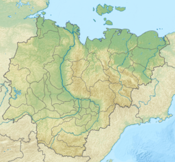
Map showing the location of the gulf in the Sakha
Republic
424:
367:
291:(Yakutia), while its eastern section belongs to the
210:
206:
193:
181:
163:
124:
114:
28:
125:
444:
387:
37:
8:
485:Bodies of water of Chukotka Autonomous Okrug
52:
451:
437:
394:
380:
25:
495:Chukotka Autonomous Okrug geography stubs
308:
480:Bodies of water of the Sakha Republic
7:
405:
403:
348:
346:
19:Not to be confused with the smaller
84:
423:. You can help Knowledge (XXG) by
366:. You can help Knowledge (XXG) by
14:
407:
350:
106:
83:
76:
209:
490:Sakha Republic geography stubs
470:Gulfs of the East Siberian Sea
1:
236:) is the largest gulf of the
113:
16:Gulf of the East Siberian Sea
232:; Russian: Колымский залив,
511:
402:
345:
18:
417:Chukotka Autonomous Okrug
293:Chukotka Autonomous Okrug
214:300 km (190 mi)
105:
71:
38:
33:
341:Arctic Coastal Dynamics
53:
419:location article is a
362:location article is a
258:Nutel'gyrgym Peninsula
256:in the west and the
144: /
336:Wetlands in Russia
297:Russian Federation
432:
431:
375:
374:
254:Medvyezhi Islands
238:East Siberian Sea
228:: Халыма хомото,
218:
217:
188:East Siberian Sea
183:Ocean/sea sources
502:
453:
446:
439:
411:
404:
396:
389:
382:
354:
347:
318:
313:
184:
159:
158:
156:
155:
154:
149:
145:
142:
141:
140:
137:
127:
110:
87:
86:
80:
64:
56:
49:
41:
40:
26:
510:
509:
505:
504:
503:
501:
500:
499:
475:Gulfs of Russia
460:
459:
458:
457:
401:
400:
327:
322:
321:
314:
310:
305:
282:Chukochya River
250:Kolyma Lowlands
246:
234:Kolymskiy Zaliv
197: countries
176:Chukochya River
152:
150:
146:
143:
138:
135:
133:
131:
130:
101:
100:
99:
98:
95:
94:
93:
92:
88:
67:
58:
43:
39:Колымский залив
24:
17:
12:
11:
5:
508:
506:
498:
497:
492:
487:
482:
477:
472:
462:
461:
456:
455:
448:
441:
433:
430:
429:
412:
399:
398:
391:
384:
376:
373:
372:
360:Sakha Republic
355:
344:
343:
338:
333:
326:
325:External links
323:
320:
319:
307:
306:
304:
301:
289:Sakha Republic
245:
242:
216:
215:
212:
208:
207:
204:
203:
198:
191:
190:
185:
179:
178:
165:
161:
160:
128:
122:
121:
116:
112:
111:
103:
102:
96:
90:
89:
82:
81:
75:
74:
73:
72:
69:
68:
66:
65:
50:
34:
31:
30:
15:
13:
10:
9:
6:
4:
3:
2:
507:
496:
493:
491:
488:
486:
483:
481:
478:
476:
473:
471:
468:
467:
465:
454:
449:
447:
442:
440:
435:
434:
428:
426:
422:
418:
413:
410:
406:
397:
392:
390:
385:
383:
378:
377:
371:
369:
365:
361:
356:
353:
349:
342:
339:
337:
334:
332:
329:
328:
324:
317:
312:
309:
302:
300:
298:
294:
290:
285:
283:
279:
274:
270:
265:
264:in the east.
263:
259:
255:
252:close to the
251:
243:
241:
239:
235:
231:
230:Xalıma xomoto
227:
223:
213:
205:
202:
199:
196:
192:
189:
186:
180:
177:
173:
172:Rauchua River
169:
166:
164:River sources
162:
157:
129:
123:
120:
117:
109:
104:
79:
70:
62:
55:
54:Xalıma xomoto
51:
47:
36:
35:
32:
27:
23:further west.
22:
425:expanding it
414:
368:expanding it
357:
311:
286:
269:Kolyma River
266:
247:
233:
229:
221:
219:
168:Kolyma River
316:GoogleEarth
273:river delta
262:Ayon Island
222:Kolyma Gulf
151: /
126:Coordinates
91:Kolyma Gulf
29:Kolyma Gulf
464:Categories
303:References
211:Max. width
148:70°N 162°E
21:Kolyma Bay
244:Geography
119:Far North
331:Location
280:and the
115:Location
295:of the
278:Rauchua
153:70; 162
46:Russian
201:Russia
57:
42:
415:This
358:This
226:Yakut
195:Basin
139:162°E
61:Yakut
421:stub
364:stub
267:The
260:and
220:The
136:70°N
466::
299:.
284:.
240:.
174:,
170:,
452:e
445:t
438:v
427:.
395:e
388:t
381:v
370:.
224:(
63:)
59:(
48:)
44:(
Text is available under the Creative Commons Attribution-ShareAlike License. Additional terms may apply.