42:
26:
343:). A decreasing trend in precipitation has lowered the water level of the lake, and a marsh that used to be at the southwest end no longer exists. The grazing of flocks of sheep and goats by nomadic herdsmen in the spring and summer has all but eliminated the aquatic vegetation at the edge of the lake. A reduced number of water birds visit the lake in winter and the
49:
222:. Located at an altitude of 2,080 metres, Aguelmame Sidi Ali has a surface area of approximately 500 hectares (1,200 acres) and a depth of 36 m (118 ft). It is near the boundary of the province of
323:
In 2005, the
Aguelmams Sidi Ali / Tifounassine complex, three mountain wetlands at altitudes between 1,900 and 2,100 m (6,234 and 6,890 ft), have been designated as a
437:
Sayad, Ahmed; Chakiri, Saïd; Martin, Claude; Bejjaji, Zohra; Echarfaoui, Hassan (2011). "Effet des conditions climatiques sur le niveau du lac Sidi Ali (Moyen Atlas, Maroc)".
679:
88:
41:
262:
rock and is formed from two basins, separated by a basal ridge which is exposed when the water level falls. It is fed by runoff, snowmelt and
647:
526:
584:
684:
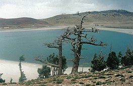
286:), but more recently, this forest has become degraded and the area around the lake has become dry, thorny scrubland dominated by
639:
Desertification and Risk
Analysis Using High and Medium Resolution Satellite Data: Training Workshop on Mapping Desertification
518:
Desertification and Risk
Analysis Using High and Medium Resolution Satellite Data: Training Workshop on Mapping Desertification
542:
117:
215:
669:
559:
674:
231:
70:
491:
468:
211:
344:
287:
347:
no longer breeds here. Despite being protected, the ruddy shelduck and other wildfowl suffer from
643:
637:
522:
516:
450:
414:
162:
442:
336:
313:
279:
270:
is 9.1 and the mineral content is relatively low with a conductivity of 1200–1600 uScm-1.
327:; they provide important over-wintering sites for migratory wetland birds including the
356:
328:
309:
247:
126:
663:
377:
251:
243:
227:
369:
324:
365:
304:
255:
585:"Note archéologique sur l'Aguelman de Sidi-Ali (Moyen-Atlas, Maroc) - Persée"
454:
103:
90:
446:
258:
at the intersection of two faults. It is located in a natural hollow in the
25:
543:"Lake Aguelmame Sidi Ali, Middle Atlas Morocco, Holocene diatom analyses"
348:
295:
219:
74:
560:"Aguelmams Sidi Ali - Tifounassine | Ramsar Sites Information Service"
250:
area of about 15.6 km (6 sq mi). It was formed in the
234:, a 842 km (325 sq mi) protected area created in 2008.
385:
299:
259:
223:
609:
409:
246:
mountains at an altitude of 2,080 m (6,824 ft) and has a
392:), are other non-native fish species also introduced in the lake.
361:
263:
317:
207:
492:"Aguelmame Sidi Ali lake in Khenifra National Park, Morocco"
267:
278:
The area surrounding the lake was once well-forested with
642:. Springer Science & Business Media. p. 150.
521:. Springer Science & Business Media. p. 146.
354:
The lake used to be the only place in the world where
308:, and these have been used to provide evidence of the
185:
177:
169:
160:
156:
148:
140:
136:
125:
80:
66:
18:
81:
8:
441:(in French). Vol. 5. pp. 251–268.
376:) was released into the lake in 1934. The
48:
15:
631:
629:
627:
636:Marini, Alberto; Talbi, Mohamed (2008).
515:Marini, Alberto; Talbi, Mohamed (2008).
316:changes the lake has undergone over the
401:
184:
176:
168:
159:
7:
298:and sediment in the lake is rich in
610:"Aguelmams Sidi Ali – Tifounassine"
469:"Khenifra National Park in Morocco"
410:"Aguelmams Sidi Ali – Tifounassine"
14:
680:Geography of Béni Mellal-Khénifra
173:Aguelmams Sidi Ali – Tifounassine
47:
40:
24:
147:
144:40 km (15 sq mi)
139:
1:
364:, lived but that fish became
65:
302:, particularly of the genus
242:The lake is located in the
701:
417:Sites Information Service
230:mountains. It is part of
197:
193:
35:
23:
685:Ramsar sites in Morocco
447:10.4000/physio-geo.2145
152:36 m (118 ft)
360:, a native species of
232:Khenifra National Park
71:Khenifra National Park
216:Béni Mellal-Khénifra
119:Google satellite map
104:33.07167°N 4.99778°W
490:s.r.o, Tripomatic.
345:great crested grebe
292:Juniperus thurifera
204:Aguelmame Sidi Ali
100: /
471:. Protected Planet
333:Tadorna ferruginea
186:Reference no.
109:33.07167; -4.99778
55:Aguelmame Sidi Ali
30:A view of the lake
19:Aguelmame Sidi Ali
649:978-1-4020-8937-4
528:978-1-4020-8937-4
390:Sander lucioperca
212:Khénifra Province
201:
200:
692:
670:Lakes of Morocco
654:
653:
633:
622:
621:
619:
617:
606:
600:
599:
597:
596:
581:
575:
574:
572:
571:
556:
550:
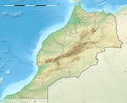
549:
547:
539:
533:
532:
512:
506:
505:
503:
502:
496:travel.sygic.com
487:
481:
480:
478:
476:
465:
459:
458:
434:
428:
427:
425:
423:
406:
284:Cedrus atlantica
115:
114:
112:
111:
110:
105:
101:
98:
97:
96:
93:
83:
51:
50:
44:
28:
16:
700:
699:
695:
694:
693:
691:
690:
689:
660:
659:
658:
657:
650:
635:
634:
625:
615:
613:
608:
607:
603:
594:
592:
589:web.archive.org
583:
582:
578:
569:
567:
564:web.archive.org
558:
557:
553:
545:
541:
540:
536:
529:
514:
513:
509:
500:
498:
489:
488:
484:
474:
472:
467:
466:
462:
436:
435:
431:
421:
419:
408:
407:
403:
398:
374:Cyprinus carpio
341:Fulica cristata
288:Spanish juniper
276:
240:
181:15 January 2005
165:
129: countries
116:
108:
106:
102:
99:
94:
91:
89:
87:
86:
62:
61:
60:
59:
58:
57:
56:
52:
31:
12:
11:
5:
698:
696:
688:
687:
682:
677:
675:Mountain lakes
672:
662:
661:
656:
655:
648:
623:
601:
576:
551:
534:
527:
507:
482:
460:
429:
400:
399:
397:
394:
357:Salmo pallaryi
329:ruddy shelduck
310:paleohydrology
275:
272:
239:
236:
199:
198:
195:
194:
191:
190:
187:
183:
182:
179:
175:
174:
171:
167:
166:
163:Ramsar Wetland
161:
158:
157:
154:
153:
150:
146:
145:
142:
138:
137:
134:
133:
130:
123:
122:
84:
78:
77:
68:
64:
63:
54:
53:
46:
45:
39:
38:
37:
36:
33:
32:
29:
21:
20:
13:
10:
9:
6:
4:
3:
2:
697:
686:
683:
681:
678:
676:
673:
671:
668:
667:
665:
651:
645:
641:
640:
632:
630:
628:
624:
611:
605:
602:
590:
586:
580:
577:
565:
561:
555:
552:
544:
538:
535:
530:
524:
520:
519:
511:
508:
497:
493:
486:
483:
470:
464:
461:
456:
452:
448:
444:
440:
433:
430:
418:
416:
411:
405:
402:
395:
393:
391:
387:
383:
379:
378:northern pike
375:
371:
367:
363:
359:
358:
352:
350:
346:
342:
338:
334:
330:
326:
321:
319:
315:
314:hydroclimatic
311:
307:
306:
301:
297:
293:
289:
285:
281:
273:
271:
269:
266:springs. The
265:
261:
257:
253:
252:Upper Miocene
249:
245:
237:
235:
233:
229:
225:
221:
217:
213:
209:
205:
196:
192:
188:
180:
172:
170:Official name
164:
155:
151:
143:
135:
131:
128:
124:
121:
120:
113:
85:
79:
76:
72:
69:
43:
34:
27:
22:
17:
638:
614:. Retrieved
604:
593:. Retrieved
591:. 2020-02-10
588:
579:
568:. Retrieved
566:. 2018-04-26
563:
554:
537:
517:
510:
499:. Retrieved
495:
485:
473:. Retrieved
463:
438:
432:
420:. Retrieved
413:
404:
389:
381:
373:
355:
353:
340:
337:crested coot
332:
322:
312:and related
303:
291:
283:
277:
244:Middle Atlas
241:
228:Middle Atlas
203:
202:
141:Surface area
118:
382:Esox lucius
370:common carp
325:Ramsar site
280:Atlas cedar
238:Description
226:within the
107: /
82:Coordinates
664:Categories
595:2024-05-07
570:2024-05-07
501:2024-04-30
439:Physio-géo
396:References
384:) and the
368:after the
335:) and the
305:Cyclotella
256:Quaternary
178:Designated
149:Max. depth
95:04°59′52″W
92:33°04′18″N
455:1958-573X
248:catchment
612:. Ramsar
475:9 August
422:25 April
349:poaching
296:plankton
67:Location
616:31 July
366:extinct
300:diatoms
294:). The
274:Ecology
220:Morocco
132:Morocco
75:Morocco
646:
525:
453:
415:Ramsar
386:zander
260:basalt
224:Ifrane
546:(PDF)
362:trout
318:aeons
264:karst
206:is a
127:Basin
644:ISBN
618:2019
523:ISBN
477:2019
451:ISSN
424:2018
208:lake
189:1468
443:doi
210:in
666::
626:^
587:.
562:.
494:.
449:.
412:.
351:.
320:.
268:pH
218:,
214:,
73:,
652:.
620:.
598:.
573:.
548:.
531:.
504:.
479:.
457:.
445::
426:.
388:(
380:(
372:(
339:(
331:(
290:(
282:(
254:/
Text is available under the Creative Commons Attribution-ShareAlike License. Additional terms may apply.