33:
321:
40:
298:. The lake is divided into three plains by two narrowings. The North Pole occupies part of the basin with depths of 6 to 10 meters. There is a small group of islands. Central reach is the deepest, with depressions up to 19.6 meters, the southern shallow, with gentle underwater slopes.
301:
The coastal shallows of the lake are covered with a mixture of sand and silt, the bottom in deep sections is covered with a thick layer of light brown mud. With the exception of the bays, the lake is overgrown with little: the width of the green border near the coast is 10–20 meters.
362:. During the existence of Lake Komsomolskoye there have been three sharp drops in the water level, so that the shore consists of small but distinctive terraces formed on the banks. The shores of the lake are indented with several bays and inlets, overgrown with
287:
282:
Lake
Komsomolskoye is 14 km (8.7 mi) long, 2 km (1.2 mi) miles wide, with a surface area of 24.6 km (9 sq mi). The main inflow of Lake Komsomolskoye is from the
32:
593:
65:
608:
227:
371:
240:
420:
457:
286:. In the south, a small stream flows into Lake Komsomolskoye. At the northern end, Lake Komsomolskoye is drained by the
375:
311:
283:
244:
119:
598:
588:
126:
315:
603:
355:
259:
343:
112:
453:"Jotnian and Postjotnian: Sandstones and diabases in the surroundings of the Gulf of Finland"
484:
Ailio, Julius (1915). "Die geographische
Entwicklung des Ladogasees in postglazialer Zeit".
271:
263:
256:
397:
359:
320:
150:
140:
582:
571:
508:
452:
97:
566:
367:
324:
291:
133:
351:
347:
332:
430:
527:
80:
67:
426:
295:
544:[The "Lake" Cooperative] (in Russian). kompromat.ru. March 6, 2000
374:. At the northern extremity of the lake are the houses of the village of
340:
541:
523:
503:
113:
102:
400:. Access to this territory is closed in violation of the Russian law.
127:
363:
336:
267:
156:
393:
387:
319:
105:
504:
Late- and postglacial history of lakes of the
Karelian Isthmus
358:
took place in the Lake Ladoga basin between 12,500 and 11,500
567:
370:. On the south-eastern shore of the lake is the village of
392:
Part of the shore is fenced by the dacha cooperative
236:
226:
222:
214:
206:
198:
190:
182:
174:
166:
162:
149:
139:
125:
111:
96:
57:
21:
451:Amantov, A.; Laitakari, I.; Poroshin, Ye (1996).
58:
331:Geologically Lake Komsomolskoye is part of the
8:
458:Geological Survey of Finland, Special Paper
39:
18:
414:
412:
408:
270:. Until 1948 it was called Kiimajärvi (
575:. Vol. 322, Issues 1–3. / April 1996.
7:
502:Davydova, Natalia N. et al. (1996).
419:Kirillova, VA; Raspopov, IM (1971).
396:, among the founders of which was
14:
594:Mesoproterozoic rifts and grabens
145:399 km (200 sq mi)
210:246 km (59 cu mi)
186:24.6 km (9 sq mi)
38:
31:
213:
205:
197:
189:
181:
173:
165:
354:). Deglaciation following the
255:is a lake in the north of the
1:
565:Simola, Heikki et al. (eds),
422:Lakes of the Leningrad Region
625:
522:Oleg Kashin (2010-07-12).
486:Bull. Comm. Géol. Finlande
429:: Lenizdat. Archived from
385:
309:
609:Lakes of Leningrad Oblast
312:Geology of the Baltic Sea
26:
202:19.6 m (64 ft)
262:, in the middle of the
328:
218:13 m (43 ft)
194:10 m (33 ft)
170:14 km (9 mi)
16:Moraine lake in Russia
524:"A picnic of protest"
323:
290:which flows into the
178:2 km (1 mi)
542:"Кооператив "Озеро""
360:radiocarbon years BP
316:Svecofennian orogeny
294:near the village of
569:. Special issue of
356:Weichsel glaciation
260:Priozersky District
77: /
329:
253:Lake Komsomolskoye
46:Lake Komsomolskoye
22:Lake Komsomolskoye
512:322.1–3, 199–204.
266:of north western
250:
249:
215:Surface elevation
81:60.783°N 30.067°E
616:
554:
553:
551:
549:
538:
532:
531:
519:
513:
500:
494:
493:
481:
475:
474:
472:
470:
448:
442:
441:
439:
438:
416:
327:around 7,000 BC.
264:Karelian Isthmus
257:Leningrad Region
129:
128:Primary outflows
115:
92:
91:
89:
88:
87:
82:
78:
75:
74:
73:
70:
60:
42:
41:
35:
19:
624:
623:
619:
618:
617:
615:
614:
613:
579:
578:
562:
557:
547:
545:
540:
539:
535:
521:
520:
516:
501:
497:
483:
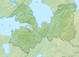
482:
478:
468:
466:
450:
449:
445:
436:
434:
418:
417:
410:
406:
390:
384:
318:
308:
288:Vesyolaya River
280:
243:
153: countries
114:Primary inflows
85:
83:
79:
76:
71:
68:
66:
64:
63:
53:
52:
51:
50:
49:
48:
47:
43:
17:
12:
11:
5:
622:
620:
612:
611:
606:
601:
596:
591:
581:
580:
577:
576:
561:
560:External links
558:
556:
555:
533:
514:
495:
476:
443:
407:
405:
402:
398:Vladimir Putin
386:Main article:
383:
380:
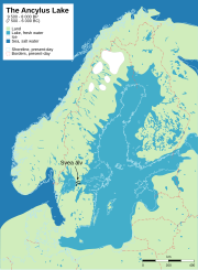
335:depression, a
307:
304:
284:Pionerka River
279:
276:
248:
247:
238:
234:
233:
230:
224:
223:
220:
219:
216:
212:
211:
208:
204:
203:
200:
196:
195:
192:
188:
187:
184:
180:
179:
176:
172:
171:
168:
164:
163:
160:
159:
154:
147:
146:
143:
141:Catchment area
137:
136:
131:
123:
122:
120:Pionerka River
117:
109:
108:
100:
94:
93:
86:60.783; 30.067
61:
55:
54:
45:
44:
37:
36:
30:
29:
28:
27:
24:
23:
15:
13:
10:
9:
6:
4:
3:
2:
621:
610:
607:
605:
602:
600:
599:Glacial lakes
597:
595:
592:
590:
587:
586:
584:
574:
573:
572:Hydrobiologia
568:
564:
563:
559:
543:
537:
534:
529:
525:
518:
515:
511:
510:
509:Hydrobiologia
505:
499:
496:
491:
487:
480:
477:
464:
460:
459:
454:
447:
444:
433:on 2019-04-03
432:
428:
424:
423:
415:
413:
409:
403:
401:
399:
395:
389:
381:
379:
377:
373:
369:
365:
361:
357:
353:
349:
345:
342:
338:
334:
326:
322:
317:
313:
305:
303:
299:
297:
293:
289:
285:
277:
275:
274:Kiimajärvi).
273:
269:
265:
261:
258:
254:
246:
242:
239:
235:
231:
229:
225:
221:
217:
209:
201:
193:
191:Average depth
185:
177:
169:
161:
158:
155:
152:
148:
144:
142:
138:
135:
132:
130:
124:
121:
118:
116:
110:
107:
104:
101:
99:
95:
90:
62:
56:
34:
25:
20:
589:Vuoksi basin
570:
548:February 20,
546:. Retrieved
536:
517:
507:
498:
489:
485:
479:
467:. Retrieved
462:
456:
446:
435:. Retrieved
431:the original
421:
391:
330:
325:Ancylus Lake
300:
292:Vuoksi River
281:
252:
251:
207:Water volume
183:Surface area
134:Vuoksi River
352:Precambrian
348:Proterozoic
333:Lake Ladoga
278:Description
237:Settlements
167:Max. length
84: /
59:Coordinates
604:Rift lakes
583:Categories
528:Kommersant
437:2017-07-21
404:References
376:Torfyanoye
372:Solovyovka
310:See also:
245:Torfyanoye
241:Solovyovka
199:Max. depth
175:Max. width
427:Leningrad
382:Notoriety
344:structure
306:Geography
296:Vasilyevo
492:: 1–159.
465:: 99–113
341:syncline
469:27 July
272:Finnish
228:Islands
103:moraine
72:30°04′E
69:60°47′N
364:sedges
337:graben
268:Russia
157:Russia
394:Ozero
388:Ozero
368:reeds
350:age (
151:Basin
550:2016
471:2015
366:and
339:and
314:and
106:lake
98:Type
346:of
585::
526:.
506:.
490:45
488:.
463:21
461:.
455:.
425:.
411:^
378:.
232:46
552:.
530:.
473:.
440:.
Text is available under the Creative Commons Attribution-ShareAlike License. Additional terms may apply.