49:
405:
287:
56:
29:
329:(13.25 km), has a mean depth of 27 ft (8.2 m) and a maximum depth of 74 ft (23 m). Its volume is approximately 28 billion US gal (110 million m) and it has 13 miles (21 km) of shoreline, about 40% of which is publicly owned. The elevation of the lake is 845', regulated by
383:
died when his plane crashed in Lake Monona on
December 10, 1967, during a storm en route to a concert in Madison. The pilot, who was Redding's manager, and four out of the five members of the
542:
537:
475:
532:
461:
48:
91:
297:
345:. Lake Monona is typically frozen for 107 days a year, give or take 10 days depending on the season. Access to the lake is by boat ramp.
452:
274:
that forms downtown
Madison. The name 'Monona' is a word believed to mean 'beautiful', although the lake was originally named by the
457:
447:
479:
330:
243:
77:
134:
348:
Monona is home to many species of fish and is a popular lake for fishing. Sport fish species include
387:(then Otis's backup band) who were on the plane, also died, with the sole-survivor being trumpeter
138:
409:
247:
217:
123:
404:
251:
221:
361:
357:
271:
286:
145:
34:
526:
369:
353:
427:
422:
400:
380:
342:
338:
267:
263:
259:
255:
130:
500:
417:
365:
184:
388:
233:
312:
299:
106:
93:
408:
Sunset over Lake Monona as viewed from Stone Bridge Park in Monona, WI. The
334:
384:
349:
333:
at the mouth of the Yahara River at Lake
Mendota. Monona is fed by three
275:
236:
373:
124:
28:
285:
326:
239:
254:. It is the second-largest of a chain of four lakes along the
412:'s skyline can be seen across the waters of Lake Monona.
476:"UW Center for Limnology: data regarding Lake Monona"
213:
205:
201:
193:
183:
175:
167:
159:
155:
144:
122:
83:
73:
21:
16:Freshwater drainage lake in Dane County, Wisconsin
84:
270:) in the area and forms the south shore of the
278:'Tchee-ho-bo-kee-xa-te-la' or 'Teepee Lake'.
8:
250:, and on the south east side by the city of
499:Wisconsin Department of Natural Resources.
246:, surrounded on three sides by the city of
18:
543:Tourist attractions in Madison, Wisconsin
501:Lake Survey Map: Monona Lake, Dane County
462:United States Department of the Interior
403:
439:
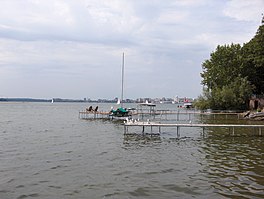
290:View of Lake Monona from Monona Terrace
538:Bodies of water of Madison, Wisconsin
7:
453:Geographic Names Information System
55:
37:and Madison skyline in the distance
14:
379:Twenty-six-year-old soul singer
54:
47:
27:
533:Lakes of Dane County, Wisconsin
458:United States Geological Survey
192:
182:
174:
166:
158:
516:, December 11, 1967, pp. 1, 4.
1:
72:
512:"Find Plane In Lake Silt".
341:), Starkweather Creek, and
559:
448:"Lake Monona (Wisconsin)"
337:: the Yahara River (from
42:
26:
197:845 ft (258 m)
163:3,274 acres (13 km)
171:27 ft (8.2 m)
413:
291:
244:Dane County, Wisconsin
179:74 ft (23 m)
78:Dane County, Wisconsin
407:
313:43.06917°N 89.35944°W
294:Lake Monona rests at
289:
209:About 107 days a year
107:43.06917°N 89.35944°W
325:. It measures 3,274
276:Ho-Chunk (Winnebago)
318:43.06917; -89.35944
309: /
185:Residence time
112:43.06917; -89.35944
103: /
414:
292:
248:Madison, Wisconsin
135:Starkweather Creek
514:The Capital Times
252:Monona, Wisconsin
227:
226:
194:Surface elevation
550:
517:
510:
504:
497:
491:
490:
488:
487:
478:. Archived from
472:
466:
465:
444:
324:
323:
321:
320:
319:
314:
310:
307:
306:
305:
302:
258:(also including
126:
118:
117:
115:
114:
113:
108:
104:
101:
100:
99:
96:
86:
58:
57:
51:
31:
19:
558:
557:
553:
552:
551:
549:
548:
547:
523:
522:
521:
520:
511:
507:
498:
494:
485:
483:
474:
473:
469:
446:
445:
441:
436:
410:City of Madison
397:
362:smallmouth bass
358:largemouth bass
317:
315:
311:
308:
303:
300:
298:
296:
295:
284:
148: countries
125:Primary inflows
111:
109:
105:
102:
97:
94:
92:
90:
89:
69:
68:
67:
66:
65:
64:
63:
59:
38:
17:
12:
11:
5:
556:
554:
546:
545:
540:
535:
525:
524:
519:
518:
505:
492:
467:
438:
437:
435:
432:
431:
430:
425:
420:
415:
396:
393:
283:
280:
225:
224:
215:
211:
210:
207:
203:
202:
199:
198:
195:
191:
190:
187:
181:
180:
177:
173:
172:
169:
165:
164:
161:
157:
156:
153:
152:
149:
142:
141:
128:
120:
119:
87:
81:
80:
75:
71:
70:
61:
60:
53:
52:
46:
45:
44:
43:
40:
39:
35:Monona Terrace
32:
24:
23:
15:
13:
10:
9:
6:
4:
3:
2:
555:
544:
541:
539:
536:
534:
531:
530:
528:
515:
509:
506:
502:
496:
493:
482:on 2008-06-19
481:
477:
471:
468:
463:
459:
455:
454:
449:
443:
440:
433:
429:
426:
424:
421:
419:
416:
411:
406:
402:
399:
398:
394:
392:
390:
386:
382:
377:
375:
371:
370:northern pike
367:
363:
359:
355:
354:lake sturgeon
351:
346:
344:
340:
336:
332:
328:
322:
288:
281:
279:
277:
273:
269:
265:
261:
257:
253:
249:
245:
241:
238:
235:
231:
223:
219:
216:
212:
208:
204:
200:
196:
188:
186:
178:
170:
168:Average depth
162:
154:
151:United States
150:
147:
143:
140:
136:
132:
129:
127:
121:
116:
88:
82:
79:
76:
50:
41:
36:
30:
25:
20:
513:
508:
495:
484:. Retrieved
480:the original
470:
451:
442:
428:Lake Kegonsa
423:Lake Waubesa
401:Lake Mendota
381:Otis Redding
378:
347:
343:Wingra Creek
339:Lake Mendota
293:
256:Yahara River
229:
228:
160:Surface area
139:Murphy Creek
131:Yahara River
418:Lake Wingra
366:muskellunge
335:tributaries
316: /
282:Description
230:Lake Monona
214:Settlements
110: /
85:Coordinates
62:Lake Monona
22:Lake Monona
527:Categories
486:2008-06-07
434:References
389:Ben Cauley
368:(muskie),
304:89°21′34″W
234:freshwater
176:Max. depth
98:89°21′34″W
33:Lake with
189:1.1 years
395:See also
385:Bar-Kays
350:bluegill
301:43°4′9″N
237:drainage
95:43°4′9″N
74:Location
374:walleye
272:isthmus
268:Waubesa
264:Kegonsa
260:Mendota
218:Madison
372:, and
266:, and
222:Monona
206:Frozen
331:locks
327:acres
232:is a
146:Basin
240:lake
242:in
529::
460:,
456:.
450:.
391:.
376:.
364:,
360:,
356:,
352:,
262:,
220:,
137:,
133:,
503:.
489:.
464:.
Text is available under the Creative Commons Attribution-ShareAlike License. Additional terms may apply.