47:
31:
379:
54:
317:. The wetlands within the IBA are shallow with extensive beds of dense sedgeland and fringing stands of shrubland and woodland. Lake Muir has been excluded from the IBA as it is unsuitable for bitterns but it has supported large numbers of
1007:
46:
344:
1123:
624:
1169:
684:
1164:
876:
1154:
436:
272:, a 694 km (268 sq mi) area of internal drainage containing a complex of wetland systems. Lake Muir may, in flood, overflow southwest into the
939:
1045:
365:
5.7 earthquake was centred at the lake on 16 September 2018 and was followed by a magnitude 4.7 quake on 13 October and a 5.4 quake on 9 November.
677:
545:
1060:
732:
652:
99:
1100:
944:
904:
881:
601:
575:
277:
1159:
670:
268:
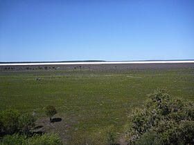
The lake has a surface area of 46 square kilometres (18 sq mi). Lake Muir and its surrounding wetland lies within the Lake
757:
709:
693:
479:
628:
571:
1055:
861:
823:
1113:
737:
273:
241:
138:
81:
329:
Lake Muir was named after brothers Thomas and John Muir, the first
European settlers in the Warren district, who settled at
1118:
992:
701:
504:
UNEP-WCMC (2022). Protected Area
Profile for Lake Muir from the World Database of Protected Areas. Accessed 3 May 2022.
914:
727:
257:
440:
977:
782:
414:
394:
253:
597:
516:
997:
828:
384:
355:
291:
747:
362:
1090:
1012:
987:
929:
866:
303:
284:
466:
354:
as Ramsar site 1050, a wetland of international importance, acknowledging its rich ecological diversity.
1035:
924:
131:
302:
A 14-square-kilometre (5.4 sq mi) section of wetland around Lake Muir has been identified by
1070:
967:
805:
314:
1075:
318:
307:
909:
833:
792:
269:
1040:
1027:
800:
762:
541:
475:
351:
350:
On 5 January 2001, a 106-square-kilometre (41 sq mi) area was designated, under the
337:
245:
170:
85:
67:
959:
347:(CALM) started monitoring the wetlands system in 1980 in order to manage the duck shooting.
657:
333:, 25 kilometres (16 mi) west of the lake, in 1852 and built a rush hut there in 1856.
982:
949:
853:
772:
742:
719:
233:
1128:
1002:
843:
340:
155:
145:
1148:
1133:
1085:
871:
249:
1108:
1017:
972:
934:
919:
752:
598:"Magnitude-4.7 earthquake rocks area surrounding Lake Muir in WA's Great Southern"
1080:
838:
777:
767:
437:"Information Sheet on Ramsar Wetlands - Muir – Byenup System, Western Australia"
815:
374:
311:
114:
101:
1050:
886:
662:
896:
237:
505:
358:
was designated in the same year by the
Government of Western Australia.
132:
287:) at the end of winter, saline by summer and dry throughout autumn.
30:
666:
474:. East Perth, WA: Water and Rivers Commission. pp. 3–5.
321:
and may prove to be globally significant for that species.
625:"Earthquake at Lake Muir shakes Perth and WA's South West"
310:(IBA) because it provides habitat for 10 or more pairs of
653:
Australian
Government Directory of Important Wetlands
1099:
1026:
958:
895:
852:
814:
791:
718:
700:
223:
216:
212:
204:
196:
188:
180:
176:
165:
154:
144:
130:
91:
77:
23:
552:. Perth, WA: Heritage Council of Western Australia
336:Historically the area was a Game Reserve, with a
877:Coorong and Lakes Alexandrina and Albert Wetland
276:catchment (and possibly also southeast into the
92:
283:Lake Muir is usually brackish (1000–3000 mg/L
678:
8:
572:"Magnitude-5.7 earthquake rocks southern WA"
1170:Lakes of the South West (Western Australia)
685:
671:
663:
468:Hydrogeology of the Muir–Unicup catchments
345:Department of Environment and Conservation
20:
1165:Important Bird Areas of Western Australia
415:"Bonzle Digital Atlas – Map of Lake Muir"
1008:Port Phillip Bay and Bellarine Peninsula
460:
458:
406:
500:
498:
910:Cape Barren Island east coast lagoons
7:
1155:Protected areas of Western Australia
602:Australian Broadcasting Corporation
576:Australian Broadcasting Corporation
395:List of lakes of Western Australia
14:
1129:Hosnies Spring (Christmas Island)
150:384 km (148 sq mi)
53:
623:Ben Anserson (9 November 2018).
377:
294:, which was designated in 2001.
52:
45:
29:
862:Banrock Station Wetland Complex
203:
200:46 km (18 sq mi)
195:
187:
179:
1046:Forrestdale and Thomsons Lakes
738:Fivebough and Tuckerbil Swamps
290:Lake Muir is protected within
1:
1124:Elizabeth and Middleton Reefs
240:area, that is located in the
76:
1119:The Dales (Christmas Island)
702:Australian Capital Territory
236:, with a larger surrounding
915:Interlaken Lakeside Reserve
465:Smith, Robin (April 2003).
1186:
1061:Lakes Argyle and Kununurra
978:Edithvale-Seaford Wetlands
1160:Ramsar sites in Australia
950:Pittwater–Orielton Lagoon
758:Little Llangothlin Lagoon
694:Ramsar sites in Australia
546:"Deeside Homestead Group"
40:
35:Lake Muir in October 2010
28:
16:Lake in Western Australia
385:Western Australia portal
356:Lake Muir Nature Reserve
292:Lake Muir Nature Reserve
208:170 m (560 ft)
184:11 km (6.8 mi)
748:Hunter Estuary Wetlands
192:5 km (3.1 mi)
1013:Western District Lakes
940:Lower Ringarooma River
930:Little Waterhouse Lake
867:Bool and Hacks Lagoons
733:Central Murray Forests
521:BirdLife International
517:"Muir-Unicup Wetlands"
439:. 2003. Archived from
304:BirdLife International
280:via Poorginup Gully).
115:34.44694°S 116.74833°E
1091:Vasse-Wonnerup System
1036:Becher Point Wetlands
315:Australasian bitterns
248:. The lake lies near
1101:External territories
1076:Peel-Yalgorup System
1071:Ord River Floodplain
993:Hattah-Kulkyne Lakes
806:Kakadu National Park
120:-34.44694; 116.74833
578:. 17 September 2018
319:Australian Shelduck
308:Important Bird Area
169:Muir-Byenup System
111: /
1114:Coral Sea Reserves
1066:Muir-Byenup System
1056:Lake Warden System
834:Great Sandy Strait
793:Northern Territory
658:Muir-Byenup System
544:(1 January 2017).
270:Muir-Byenup System
1142:
1141:
1041:Eighty Mile Beach
1028:Western Australia
882:Piccaninnie Ponds
824:Bowling Green Bay
801:Cobourg Peninsula
763:Macquarie Marshes
604:. 13 October 2018
542:Shire of Manjimup
352:Ramsar Convention
256:and southeast of
246:Western Australia
227:
226:
205:Surface elevation
86:Western Australia
68:Western Australia
1177:
1018:Western Port Bay
829:Currawinya Lakes
687:
680:
673:
664:
640:
639:
637:
635:
629:News Corporation
620:
614:
613:
611:
609:
594:
588:
587:
585:
583:
568:
562:
561:
559:
557:
538:
532:
531:
529:
527:
513:
507:
502:
493:
492:
490:
488:
473:
462:
453:
452:
450:
448:
433:
427:
426:
424:
422:
411:
387:
382:
381:
380:
134:
133:Primary outflows
126:
125:
123:
122:
121:
116:
112:
109:
108:
107:
104:
94:
56:
55:
49:
33:
21:
1185:
1184:
1180:
1179:
1178:
1176:
1175:
1174:
1145:
1144:
1143:
1138:
1095:
1022:
998:Kerang Wetlands
988:Gunbower Forest
983:Gippsland Lakes
954:
945:Moulting Lagoon
891:
854:South Australia
848:
810:
787:
773:Narran Wetlands
743:Gwydir Wetlands
720:New South Wales
714:
696:
691:
649:
644:
643:
633:
631:
622:
621:
617:
607:
605:
596:
595:
591:
581:
579:
570:
569:
565:
555:
553:
540:
539:
535:
525:
523:
515:
514:
510:
503:
496:
486:
484:
482:
471:
464:
463:
456:
446:
444:
443:on 31 July 2008
435:
434:
430:
420:
418:
413:
412:
408:
403:
391:
390:
383:
378:
376:
371:
327:
300:
298:Flora and fauna
278:Frankland River
266:
234:freshwater lake
158: countries
119:
117:
113:
110:
105:
102:
100:
98:
97:
73:
72:
71:
70:
64:
63:
62:
61:
57:
36:
17:
12:
11:
5:
1183:
1181:
1173:
1172:
1167:
1162:
1157:
1147:
1146:
1140:
1139:
1137:
1136:
1131:
1126:
1121:
1116:
1111:
1105:
1103:
1097:
1096:
1094:
1093:
1088:
1083:
1078:
1073:
1068:
1063:
1058:
1053:
1048:
1043:
1038:
1032:
1030:
1024:
1023:
1021:
1020:
1015:
1010:
1005:
1003:Lake Albacutya
1000:
995:
990:
985:
980:
975:
970:
964:
962:
956:
955:
953:
952:
947:
942:
937:
932:
927:
922:
917:
912:
907:
905:Apsley Marshes
901:
899:
893:
892:
890:
889:
884:
879:
874:
869:
864:
858:
856:
850:
849:
847:
846:
844:Shoalwater Bay
841:
836:
831:
826:
820:
818:
812:
811:
809:
808:
803:
797:
795:
789:
788:
786:
785:
780:
778:Paroo Wetlands
775:
770:
765:
760:
755:
750:
745:
740:
735:
730:
724:
722:
716:
715:
713:
712:
706:
704:
698:
697:
692:
690:
689:
682:
675:
667:
661:
660:
655:
648:
647:External links
645:
642:
641:
615:
589:
563:
533:
508:
494:
480:
454:
428:
405:
404:
402:
399:
398:
397:
389:
388:
373:
372:
370:
367:
326:
323:
299:
296:
265:
262:
225:
224:
221:
220:
218:
214:
213:
210:
209:
206:
202:
201:
198:
194:
193:
190:
186:
185:
182:
178:
177:
174:
173:
167:
163:
162:
159:
152:
151:
148:
146:Catchment area
142:
141:
136:
128:
127:
95:
89:
88:
79:
75:
74:
65:
59:
58:
51:
50:
44:
43:
42:
41:
38:
37:
34:
26:
25:
15:
13:
10:
9:
6:
4:
3:
2:
1182:
1171:
1168:
1166:
1163:
1161:
1158:
1156:
1153:
1152:
1150:
1135:
1132:
1130:
1127:
1125:
1122:
1120:
1117:
1115:
1112:
1110:
1107:
1106:
1104:
1102:
1098:
1092:
1089:
1087:
1086:Toolibin Lake
1084:
1082:
1079:
1077:
1074:
1072:
1069:
1067:
1064:
1062:
1059:
1057:
1054:
1052:
1049:
1047:
1044:
1042:
1039:
1037:
1034:
1033:
1031:
1029:
1025:
1019:
1016:
1014:
1011:
1009:
1006:
1004:
1001:
999:
996:
994:
991:
989:
986:
984:
981:
979:
976:
974:
971:
969:
968:Barmah Forest
966:
965:
963:
961:
957:
951:
948:
946:
943:
941:
938:
936:
933:
931:
928:
926:
923:
921:
918:
916:
913:
911:
908:
906:
903:
902:
900:
898:
894:
888:
885:
883:
880:
878:
875:
873:
872:Coongie Lakes
870:
868:
865:
863:
860:
859:
857:
855:
851:
845:
842:
840:
837:
835:
832:
830:
827:
825:
822:
821:
819:
817:
813:
807:
804:
802:
799:
798:
796:
794:
790:
784:
781:
779:
776:
774:
771:
769:
766:
764:
761:
759:
756:
754:
751:
749:
746:
744:
741:
739:
736:
734:
731:
729:
726:
725:
723:
721:
717:
711:
708:
707:
705:
703:
699:
695:
688:
683:
681:
676:
674:
669:
668:
665:
659:
656:
654:
651:
650:
646:
630:
626:
619:
616:
603:
599:
593:
590:
577:
573:
567:
564:
551:
547:
543:
537:
534:
522:
518:
512:
509:
506:
501:
499:
495:
483:
481:1-920849-12-2
477:
470:
469:
461:
459:
455:
442:
438:
432:
429:
416:
410:
407:
400:
396:
393:
392:
386:
375:
368:
366:
364:
359:
357:
353:
348:
346:
342:
339:
338:duck shooting
334:
332:
324:
322:
320:
316:
313:
309:
305:
297:
295:
293:
288:
286:
281:
279:
275:
271:
263:
261:
259:
255:
251:
250:Muirs Highway
247:
243:
239:
235:
231:
222:
219:
215:
211:
207:
199:
191:
183:
175:
172:
168:
164:
160:
157:
153:
149:
147:
143:
140:
137:
135:
129:
124:
96:
90:
87:
83:
80:
69:
48:
39:
32:
27:
22:
19:
1134:Pulu Keeling
1109:Ashmore Reef
1065:
973:Corner Inlet
935:Logan Lagoon
920:Jocks Lagoon
753:Lake Pinaroo
710:Ginini Flats
632:. Retrieved
618:
606:. Retrieved
592:
580:. Retrieved
566:
554:. Retrieved
549:
536:
524:. Retrieved
520:
511:
485:. Retrieved
467:
445:. Retrieved
441:the original
431:
419:. Retrieved
409:
360:
349:
335:
330:
328:
301:
289:
282:
267:
229:
228:
197:Surface area
66:Location in
18:
1081:Roebuck Bay
839:Moreton Bay
783:Towra Point
768:Myall Lakes
264:Description
252:, north of
181:Max. length
171:Ramsar Site
166:Designation
118: /
106:116°44′54″E
93:Coordinates
1149:Categories
816:Queensland
634:9 November
608:9 November
582:9 November
556:22 January
526:21 January
487:21 January
401:References
312:endangered
274:Deep River
244:region of
242:South West
217:References
189:Max. width
139:Deep River
103:34°26′49″S
82:South West
1051:Lake Gore
887:Riverland
728:Blue Lake
363:magnitude
230:Lake Muir
161:Australia
60:Lake Muir
24:Lake Muir
960:Victoria
897:Tasmania
369:See also
258:Manjimup
238:wetlands
78:Location
925:Lavinia
550:inHerit
447:2 March
421:2 March
343:. The
331:Deeside
325:History
254:Walpole
478:
417:. 2009
341:season
306:as an
472:(PDF)
232:is a
156:Basin
636:2018
610:2018
584:2018
558:2017
528:2017
489:2017
476:ISBN
449:2009
423:2009
285:TDS
1151::
627:.
600:.
574:.
548:.
519:.
497:^
457:^
361:A
260:.
84:,
686:e
679:t
672:v
638:.
612:.
586:.
560:.
530:.
491:.
451:.
425:.
Text is available under the Creative Commons Attribution-ShareAlike License. Additional terms may apply.