31:
383:
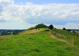
A Marilyn is a hill of any height with a drop of 150 metres or more on all sides. In other words, a relatively high hill. The
Marilyns in Britain and the Isle of Man are listed in a book called The Relative Hills of Britain (RHB) by Alan Dawson, published by Cicerone Press in April 1992. Details of
199:
Area of
Outstanding Natural Beauty. Long Knoll is the most westerly part of the remains of a chalk plateau. It forms a ridge that runs east and west for about a mile, and is 60 m (200 ft) higher than the surrounding land. The south-facing slope has a mosaic of longer and shorter turfs and
1025:
1066:
1035:
1061:
1030:
1015:
423:
1040:
1020:
1010:
414:
115:
769:
407:
148:
188:
694:
889:
749:
864:
604:
584:
400:
719:
30:
764:
499:
144:
109:
1071:
774:
729:
644:
1076:
989:
564:
524:
168:
to the north. The ridge is 288 metres (945 ft) above sea level at its highest point and it is possible to view
939:
679:
589:
352:
904:
874:
669:
649:
574:
392:
233:
328:
819:
794:
734:
609:
444:
213:
914:
754:
544:
509:
439:
307:
177:
169:
66:
56:
949:
909:
449:
276:
272:
161:
924:
919:
779:
654:
614:
292:
271:
The north-facing slope, by contrast, has more mosses and bryophytes on the closely grazed turf, with
261:
237:
929:
724:
624:
594:
539:
459:
249:
241:
217:
160:, some 1.5 kilometres (1 mi) in length, and forms the boundary between the civil parishes of
964:
284:
257:
78:
944:
634:
534:
474:
434:
296:
265:
245:
229:
192:
969:
959:
884:
859:
839:
784:
704:
994:
979:
879:
869:
699:
689:
599:
549:
484:
464:
288:
196:
181:
157:
128:
123:
709:
569:
974:
954:
849:
844:
809:
789:
744:
554:
504:
303:
253:
173:
165:
83:
1055:
984:
834:
684:
629:
519:
514:
494:
489:
280:
225:
209:
934:
894:
814:
799:
739:
714:
664:
639:
619:
454:
205:
71:
829:
579:
469:
221:
824:
659:
899:
854:
804:
674:
559:
529:
153:
98:
479:
187:
The hill is the site of the 34.2-hectare (85-acre) Long Knoll biological
102:
291:
is an unusual species to find on chalk soils, and other herbs include
46:
378:
201:
396:
384:
subsequent changes have been published in a series of updates.
424:
Biological Sites of
Special Scientific Interest in Wiltshire
248:. Some of the less common chalk grassland herbs include
1067:
Sites of
Special Scientific Interest notified in 1971
204:. Here grow a typical calcareous community including
122:
108:
94:
89:
77:
65:
55:
45:
40:
23:
1062:Sites of Special Scientific Interest in Wiltshire
152:) is a hill in the west of the English county of
408:
8:
415:
401:
393:
347:
345:
299:and an abundance of devil's-bit scabious.
20:
329:"Long Knoll and Little Knoll, Kilmington"
197:Cranborne Chase and West Wiltshire Downs
319:
310:of at least 150 metres (492 ft).
200:has a mixture of grasses, sedges and
7:
770:Lower Coombe and Ferne Brook Meadows
189:Site of Special Scientific Interest
695:Homington and Coombe Bissett Downs
14:
381:. The Relative Hills of Britain.
865:Restrop Farm and Brockhurst Wood
29:
302:Long Knoll is categorised as a
890:Scratchbury & Cotley Hills
750:Langley Wood and Homan's Copse
720:Kennet and Lambourn Floodplain
327:Timlett, Paul (7 April 2019).
18:Mountain in Wiltshire, England
1:
765:Loosehanger Copse and Meadows
500:Brickworth Down and Dean Hill
775:Lower Woodford Water Meadows
605:Dank's Down and Truckle Hill
585:Colerne Park and Monk's Wood
195:in 1971, and is part of the
990:Wylye and Church Dean Downs
565:Cloatley Manor Farm Meadows
525:Calstone and Cherhill Downs
1093:
1003:
730:Knapp and Barnett's Downs
680:Harries Ground, Rodbourne
590:The Coombes, Hinton Parva
430:
28:
905:Starveall and Stony Down
875:Roundway Down and Covert
650:Goldborough Farm Meadows
61:171 m (561 ft)
820:Picket and Clanger Wood
795:North Meadow, Cricklade
735:Knighton Downs and Wood
610:Distillery Farm Meadows
445:Baverstock Juniper Bank
35:Long view of Long Knoll
915:Stockton Wood and Down
755:Little Grubbins Meadow
545:Chilton Foliat Meadows
510:Britford Water Meadows
308:topographic prominence
950:Upper Waterhay Meadow
910:Steeple Langford Down
450:Bencroft Hill Meadows
925:Stratford Toney Down
920:Stoke Common Meadows
780:Midford Valley Woods
655:Great Cheverell Hill
615:East Harnham Meadows
250:clustered bellflower
246:devil's-bit scabious
222:common quaking-grass
1072:Marilyns of England
930:Sutton Lane Meadows
625:Emmett Hill Meadows
595:Cotswold Water Park
540:Chickengrove Bottom
460:Bincknoll Dip Woods
254:early purple orchid
170:King Alfred's Tower
156:. It is a ridge of
1077:Hills of Wiltshire
1007:Neighbouring areas
965:Whiteparish Common
285:crested hair-grass
41:Highest point
1049:
1048:
945:Tytherington Down
635:Fonthill Grottoes
535:Chilmark Quarries
475:Bowerchalke Downs
440:River Avon System
435:Acres Farm Meadow
358:. Natural England
273:tufted hair-grass
164:to the south and
138:
137:
1084:
960:West Yatton Down
885:Savernake Forest
860:Ravensroost Wood
725:King's Play Hill
705:Inwood, Warleigh
417:
410:
403:
394:
387:
386:
374:
368:
367:
365:
363:
357:
349:
340:
339:
337:
335:
324:
224:, together with
214:meadow oat-grass
151:
118:
33:
21:
1092:
1091:
1087:
1086:
1085:
1083:
1082:
1081:
1052:
1051:
1050:
1045:
1026:Gloucestershire
999:
995:Yarnbury Castle
980:Winklebury Hill
970:Whitesheet Hill
880:Salisbury Plain
870:Rotherley Downs
700:Honeybrook Farm
690:Heath Hill Farm
600:Cranborne Chase
550:Clattinger Farm
485:Bracknell Croft
465:Blackmoor Copse
426:
421:
391:
390:
376:
375:
371:
361:
359:
355:
351:
350:
343:
333:
331:
326:
325:
321:
316:
289:Common valerian
277:false oat-grass
258:horseshoe vetch
184:on clear days.
182:Glastonbury Tor
178:Black Mountains
158:chalk grassland
147:
114:
36:
19:
12:
11:
5:
1090:
1088:
1080:
1079:
1074:
1069:
1064:
1054:
1053:
1047:
1046:
1044:
1043:
1038:
1033:
1028:
1023:
1018:
1013:
1008:
1004:
1001:
1000:
998:
997:
992:
987:
982:
977:
975:Win Green Down
972:
967:
962:
957:
955:Upton Cow Down
952:
947:
942:
937:
932:
927:
922:
917:
912:
907:
902:
897:
892:
887:
882:
877:
872:
867:
862:
857:
852:
850:Prescombe Down
847:
845:Porton Meadows
842:
837:
832:
827:
822:
817:
812:
810:Parsonage Down
807:
802:
797:
792:
790:The New Forest
787:
782:
777:
772:
767:
762:
757:
752:
747:
745:Landford Heath
742:
737:
732:
727:
722:
717:
712:
707:
702:
697:
692:
687:
682:
677:
672:
667:
662:
657:
652:
647:
642:
637:
632:
627:
622:
617:
612:
607:
602:
597:
592:
587:
582:
577:
572:
567:
562:
557:
555:Clearbury Down
552:
547:
542:
537:
532:
527:
522:
517:
512:
507:
505:Brimsdown Hill
502:
497:
492:
487:
482:
477:
472:
467:
462:
457:
452:
447:
442:
437:
431:
428:
427:
422:
420:
419:
412:
405:
397:
389:
388:
369:
341:
318:
317:
315:
312:
306:, a hill with
293:autumn gentian
266:chalk milkwort
242:small scabious
210:sheep's-fescue
174:Cranmore Tower
166:Maiden Bradley
145:grid reference
136:
135:
126:
120:
119:
112:
106:
105:
96:
92:
91:
87:
86:
81:
75:
74:
69:
63:
62:
59:
53:
52:
49:
43:
42:
38:
37:
34:
26:
25:
17:
13:
10:
9:
6:
4:
3:
2:
1089:
1078:
1075:
1073:
1070:
1068:
1065:
1063:
1060:
1059:
1057:
1042:
1039:
1037:
1034:
1032:
1029:
1027:
1024:
1022:
1019:
1017:
1014:
1012:
1009:
1006:
1005:
1002:
996:
993:
991:
988:
986:
985:Winsley Mines
983:
981:
978:
976:
973:
971:
968:
966:
963:
961:
958:
956:
953:
951:
948:
946:
943:
941:
938:
936:
933:
931:
928:
926:
923:
921:
918:
916:
913:
911:
908:
906:
903:
901:
898:
896:
893:
891:
888:
886:
883:
881:
878:
876:
873:
871:
868:
866:
863:
861:
858:
856:
853:
851:
848:
846:
843:
841:
838:
836:
835:Pincombe Down
833:
831:
828:
826:
823:
821:
818:
816:
813:
811:
808:
806:
803:
801:
798:
796:
793:
791:
788:
786:
785:Morgan's Hill
783:
781:
778:
776:
773:
771:
768:
766:
763:
761:
758:
756:
753:
751:
748:
746:
743:
741:
738:
736:
733:
731:
728:
726:
723:
721:
718:
716:
713:
711:
708:
706:
703:
701:
698:
696:
693:
691:
688:
686:
685:Haydon Meadow
683:
681:
678:
676:
673:
671:
668:
666:
663:
661:
658:
656:
653:
651:
648:
646:
643:
641:
638:
636:
633:
631:
630:Figsbury Ring
628:
626:
623:
621:
618:
616:
613:
611:
608:
606:
603:
601:
598:
596:
593:
591:
588:
586:
583:
581:
578:
576:
573:
571:
568:
566:
563:
561:
558:
556:
553:
551:
548:
546:
543:
541:
538:
536:
533:
531:
528:
526:
523:
521:
520:Burderop Wood
518:
516:
515:Burcombe Down
513:
511:
508:
506:
503:
501:
498:
496:
495:Bratton Downs
493:
491:
490:Bradley Woods
488:
486:
483:
481:
478:
476:
473:
471:
468:
466:
463:
461:
458:
456:
453:
451:
448:
446:
443:
441:
438:
436:
433:
432:
429:
425:
418:
413:
411:
406:
404:
399:
398:
395:
385:
380:
377:Alan Dawson.
373:
370:
354:
348:
346:
342:
330:
323:
320:
313:
311:
309:
305:
300:
298:
294:
290:
286:
282:
278:
274:
269:
267:
263:
259:
255:
251:
247:
243:
239:
235:
231:
227:
223:
219:
215:
211:
207:
206:glaucus sedge
203:
198:
194:
190:
185:
183:
179:
175:
171:
167:
163:
159:
155:
150:
146:
142:
133:
130:
127:
125:
121:
117:
113:
111:
107:
104:
100:
97:
93:
88:
85:
82:
80:
76:
73:
70:
68:
64:
60:
58:
54:
50:
48:
44:
39:
32:
27:
22:
16:
935:Throope Down
895:Silbury Hill
815:Pewsey Downs
800:Odstock Down
759:
740:Landford Bog
715:River Kennet
710:Jones's Mill
665:Gutch Common
645:Gallows Hill
640:Fyfield Down
620:Ebsbury Down
570:Clout's Wood
455:Bentley Wood
382:
372:
360:. Retrieved
353:"Long Knoll"
332:. Retrieved
322:
301:
270:
262:kidney vetch
230:salad burnet
191:, which was
186:
140:
139:
131:
72:Beacon Batch
15:
1036:Oxfordshire
840:Porton Down
830:Pike Corner
580:Cockey Down
575:Coate Water
470:Botley Down
218:heath-grass
67:Parent peak
1056:Categories
940:River Till
825:Piggledene
760:Long Knoll
660:Great Yews
379:"Marilyns"
314:References
297:fairy flax
281:red fescue
162:Kilmington
141:Long Knoll
132:Landranger
57:Prominence
24:Long Knoll
1031:Hampshire
1016:Berkshire
900:Spye Park
855:Rack Hill
805:Out Woods
675:Hang Wood
560:Cley Hill
530:Camp Down
234:rock-rose
154:Wiltshire
99:Wiltshire
90:Geography
47:Elevation
1041:Somerset
670:Ham Hill
480:Box Mine
362:24 March
334:25 March
193:notified
149:ST794376
124:Topo map
116:ST786376
95:Location
304:Marilyn
226:cowslip
110:OS grid
103:England
84:Marilyn
79:Listing
1021:Dorset
238:betony
176:, the
356:(PDF)
202:forbs
1011:Avon
364:2020
336:2020
283:and
264:and
244:and
220:and
180:and
134:183
51:288
1058::
344:^
295:,
287:.
279:,
275:,
268:.
260:,
256:,
252:,
240:,
236:,
232:,
228:,
216:,
212:,
208:,
172:,
129:OS
101:,
416:e
409:t
402:v
366:.
338:.
143:(
Text is available under the Creative Commons Attribution-ShareAlike License. Additional terms may apply.