1582:
1331:
306:
179:
871:
294:
770:. The operation of the dam caused flooding of the Lower Brule community and surrounding bottomlands in the heart of the reservation. The waters inundated miles of roadways and a significant amount of the most productive and fertile farmland of the Reservation; it destroyed most of the Reservation’s native trees, shrubs and medicinal plants, which were located chiefly along the river bottomlands. By Public Law 87-734 (76 Stat. 698 et seq.), the
1160:
77:
36:
675:
862:
health delivery services. The Lower Brule IHS Service Unit operates a dental clinic, medical clinic and conducts several outreach programs, which provide services to the members of the Lower Brule Sioux Tribe on a regular basis, and to anyone in an emergency. Full-service hospital facilities are available in the neighboring communities of
Chamberlain and Pierre.
960:, warriors were tried by a US military tribunal. Thirty-nine Dakota warriors were sentenced to be executed by hanging, and one was spared. More than 250 men were held several years as prisoners. The group from South Brule made their ride to encourage healing and reconciliation, both within their group, and for the people they encountered. A documentary film,
836:. The Lower Brule Sioux Tribe, in coordination with the Indian Health Service, operates a sewage disposal and treatment system for the towns of Lower Brule and West Brule. The major treatment for wastewater is evaporation and settling in evaporation and settling ponds in two lagoon areas; the system uses limited aeration.
861:
The tribe contracts with Indian Health
Services to operate a Tribal Health Department that oversees the tribal ambulance services and employs Community Health Representatives. The Tribal Health Department provides examinations and eyeglasses to tribal members at reduced costs, as well as coordinating
857:
Lower Brule has an elderly center that provides an elderly nutrition program and other activities and a teen center that sponsors youth recreational activities. The tribe’s $ 5.8 million
Veteran's Memorial Community Center has a swimming pool, full-size basketball court, weight and exercise rooms and
777:
In 1997 the federal government enacted the Lower Brule
Infrastructure Development Trust Fund Act in compensation for the lands and infrastructure lost due to construction of the Big Bend Dam and flooding of the reservoir. The act was also intended to enable the tribe to share in the benefits of these
738:
The Lower Brule Sioux Tribal courts are established under a quasi-separation of power relationship with the tribal government. The 1986 constitution/by-law amendments created the chief judge as an elected position with a 4-year term. While the tribal council is the final authority on the reservation,
878:
The Golden
Buffalo Casino operates a convention center with a capacity of 120 people. A horseman's club sponsors several "Play Days" throughout the summer. The tribe has a recreational area and boat launch at South Iron Nation and other informal beach areas, and boat ramps along the shoreline of the
781:
In response, the tribe created a plan for how it would use such funds for facilities and development to aid the tribe. It also established the
Infrastructure Development Authority, a committee of tribal members who oversee the trust fund, and recommend action and expenditures to the tribal council.
848:
funds. The Lower Brule
Housing Authority manages 228 of the homes. Only 36.8 percent of the units on the reservation are owner-occupied, compared to a state average of 68.2 percent. The housing market is very tight on the reservation, with the majority of housing intended for low-income residents.
682:
The Lower Brule Sioux Tribe is a sovereign nation defined by its government-to-government relationship with the United States. As part of the Great Sioux Nation, the tribe signed treaties in 1824, 1851, 1865 and 1868 with the federal government that constitute the legal documents establishing
788:
Local telephone service is furnished by the Golden West
Telephone Company, as well as various cell phone providers. Internet services are available through Golden West and the West Central Rural Electric Cooperative. The Lower Brule Sioux Tribe is a member of the West Central Rural Electric
891:
provides the nearest landing strip and bus service. Truck service is available locally, and most retail businesses on the reservation receive service from suppliers in distributor-owned trucks. There are charter buses and limousines serving patrons of the Golden
Buffalo Casino, and
755:, authorized by Congress in 1944 for flood control, two major dams and other flood control projects were built in this area by the federal government. It acquired property on the Lower Brule Indian Reservation for two dam projects: 7,997 acres of Indian land for the
796:
The Tribe operates a propane company and serves all residences within the reservation, as well as areas adjacent to the reservation. Unleaded and diesel gasoline are available at the local gas station. Fuel oil is available from the nearest
Fanners Union in
792:
The reservation has approximately 200 miles (320 km) of roads. These include 107 miles (172 km) of gravel roads, 65 miles (105 km) of asphalt, 11 miles (18 km) of graded dirt roads, and 10 miles (16 km) of unimproved roads.
929:(1815–1894) led the Lower Brule Sioux Tribe through some of its most challenging years. He worked both as a warrior and statesman to ensure the survival of his people. Iron Nation signed the treaty to establish the Great Sioux Reservation in 1868.
697:
Tribal affairs are conducted by a six-member tribal council who are elected to serve two-year terms. Council offices include the chairman, vice-chairman, secretary/treasurer, and three council members. The tribal council chairman serves as the
782:
Since establishment of the trust fund, the authority has supervised development of the administration building and community center located in Lower Brule. The authority is also overseeing construction of the Lower Brule Justice Center.
722:. The primaries are held in August and the general is held in September, with officials being seated during the October regular meeting. Council members also serve as officers or council representatives on various boards and committees.
828:, operates a solid waste collection and transfer facility. The Solid Waste Program gathers all solid waste from receptacles located throughout the reservation. All solid waste is disposed in approved landfill facilities in
939:. Jandreau was elected to the Lower Brule Sioux Tribal Council an unprecedented 22 consecutive two-year terms. He served as chairman for 18 terms; his final term was only six months as he died while in office.
742:
The Lower Brule Sioux Court system also has established an appellate court and attendant processes. The court hears all civil and minor criminal cases, while the federal courts hear all major felony cases.
936:
1148:
646:
station find a new site for a transmission tower on Medicine Butte that had fallen. Medicine Butte rises about 200 feet (61 m) above the prairie and is sacred to the Sicangu. The town of
1520:
691:
1734:
1269:
805:
serves as a virtually unlimited water source for the Lower Brule community. The Lower Brule Sioux Tribe's Rural Water System (RWSS) supplies clean water to the communities of
690:
of June 18, 1934. Its constitution was ratified on July 11, 1936, and bylaws were approved in 1960. The tribe has contracted several aspects of self-government under the 1975
1744:
322:
1141:
778:
projects. It provided for payments to the tribe of amounts beginning in 1998 and annually until the aggregated of $ 39.3 million had been accumulated in the trust fund.
305:
1739:
845:
1126:
94:
49:
935:(1943–2015) helped lead the Lower Brule Sioux Tribe during difficult years of transition immediately prior to, and 40 continuous years after, the passage of the
916:. In addition, the tribe is involved in a video-cultural program in which students, teachers and elders document important cultural activities and histories.
1134:
293:
908:
program, a K-5 elementary school, a 6-8 middle school, and a 9-12 high school. The tribe also operates the Lower Brule Community College, accredited under
1513:
694:, PL 93-638. On June 17, 1974, the constitution and bylaws were amended, and on September 2, 1986, they were again amended and a code of ethics adopted.
774:
was to provide mitigation for such damages, including replacing roads and facilities. The government failed to carry out its obligations under the act.
956:, reaching it by December 26, the 150th anniversary of the largest mass execution in United States history. After bands surrendered at the end of the
849:
The tribe is planning to develop additional market-rate housing to meet the needs of tribal residents who do not satisfy the low-income requirements.
714:. The tribal council appoints a sergeant at arms, a chaplain, and other officers as necessary. Offices are held for two years. Elections consist of a
710:
A general election is held on the first Tuesday of September in even-numbered years. Chairman, vice-chairman, and secretary and treasurer are elected
1262:
642:
The tribe has been working to improve the environment of the reservation and to protect its sacred places. In 2013, the tribe requested that the
896:
terminals are located in Chamberlain and Pierre. River City Transit runs a daily bus/van transportation service between Lower Brule and Pierre.
789:
Cooperative. The majority of tribal members are also Cooperative members, as it is the major electricity provider in west central South Dakota.
636:
1506:
767:
141:
1204:
113:
200:
1729:
1255:
55:
1080:
1224:
120:
631:(burnt), the name French fur traders used for the Sicangu in the late 17th century. The Sicangu divided into the Lower Brule and the
1641:
1179:
752:
240:
222:
160:
63:
17:
813:
for both domestic and agricultural use. This system is a part of the Mni Wiconi Water Project, authorized to provide water for the
1219:
1194:
1498:
127:
1247:
98:
1039:
109:
1209:
1184:
521:
1530:
1189:
513:
381:
1699:
1608:
1478:
1007:
193:
187:
1436:
1279:
1229:
1214:
509:
377:
87:
1571:
1552:
1455:
1377:
888:
806:
687:
560:
or Santee, who use the autonymns Mdewakantonwan, Wahpetowan, Wahpekute, or Sisseton, range in territory from the
533:
952:
veteran, organized a group ride by horseback in 2012 following a vivid dream. They traveled from South Brule to
785:
The tribe has established the Buffalo Interpretive Center, providing insight into the people and their customs.
204:
1387:
810:
659:
1369:
1016:
909:
699:
134:
870:
1359:
1349:
1301:
814:
798:
647:
467:
1676:
1671:
1613:
833:
825:
771:
663:
1706:
1623:
1485:
1382:
1354:
1320:
905:
829:
456:
1633:
1618:
1603:
1593:
1422:
1412:
1397:
913:
818:
635:, or Upper Brule, in the late 18th century. The Lower Brule favored lands at the confluence of the
404:
1666:
1407:
1164:
1012:
957:
953:
497:
446:
284:
1074:
608:. A common history and language, a strong respect for the land and nature, the common use of
964:, was made of their journey, and they are distributing it for free, as part of the healing.
932:
756:
719:
715:
545:
1120:
1084:
893:
739:
it has formally acknowledged the legal authority necessarily vested in the tribal courts.
678:
Two "painted horses" grazing near the Missouri River on the Lower Brule Indian Reservation
650:
developed nearby. KELO-TV agreed to the tribe's request and placed a new tower elsewhere.
605:
553:
549:
273:
573:
565:
505:
981:
1723:
557:
529:
357:
1168:
1159:
887:
Commercial airline and freight train services are available in Pierre. The town of
760:
730:
Meetings are held the first Wednesday of each month with a quorum of five members.
621:
517:
367:
311:
568:, known as the Ihanktonwan/Yankton or Yanktonai/Ihanktonwanna, range from eastern
1545:
1294:
949:
926:
802:
617:
593:
76:
1658:
1447:
581:
561:
821:, Lower Brule Reservation and counties located in west-central South Dakota.
337:
324:
658:
Major employers are the Lower Brule Sioux Tribe, its Golden Buffalo Casino,
639:
and the Missouri River, while the Upper Brule lived further south and west.
613:
609:
569:
544:
The Sioux consist of a group of self-governing tribes speaking one of three
437:
674:
604:, traditionally ranged from lands east of the Missouri River valley to the
844:
There are 392 residences on the reservation, 300 of them constructed with
1690:‡This populated place also has portions in an adjacent county or counties
1469:‡This populated place also has portions in an adjacent county or counties
1096:
711:
601:
597:
589:
1114:
524:
on the east bank of the river. The Lower Brule Sioux are members of the
1044:
683:
boundaries and recognizing the rights of sovereign tribal governments.
643:
585:
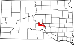
525:
576:
valley. The Lakota, or Western Teton/Tituwan Sioux, consisting of the
766:
In 1963, the Big Bend Dam on the Missouri River was completed by the
577:
18:
Lower Brule Sioux Tribe of the Lower Brule Reservation, South Dakota
869:
673:
463:
442:
1077:
Lower Brule Sioux Tribe Infrastructure Development Trust Fund Act
612:
and the reverence held for the stone, and ceremonies such as the
1563:
1341:
1312:
1502:
1251:
1130:
937:
Indian Self-Determination and Education Assistance Act of 1975
172:
70:
29:
1240:
No reservation in the state, trust lands or legal status only
666:. The gaming casino has generated new revenue for the tribe.
1580:
1329:
478:
824:
The Lower Brule Sioux Tribe, in coordination with the
692:
Indian Self Determination and Education Assistance Act
298:
Administration Center, Lower Brule Indian Reservation
1685:
1657:
1632:
1592:
1562:
1464:
1446:
1421:
1396:
1368:
1340:
1311:
474:
453:
436:
428:
423:
415:
410:
400:
392:
387:
373:
363:
353:
260:
101:. Unsourced material may be challenged and removed.
27:Indian reservation in South Dakota, United States
846:U.S. Department of Housing and Urban Development
904:The Lower Brule education system consists of a
1514:
1263:
1142:
8:
1735:American Indian reservations in South Dakota
627:The name "Brule" comes from the French word
520:in the United States. It is adjacent to the
491:
310:Location of Lower Brule Indian Reservation,
265:
1070:
1068:
1066:
1064:
1062:
64:Learn how and when to remove these messages
1581:
1521:
1507:
1499:
1270:
1256:
1248:
1149:
1135:
1127:
1040:"Moving KPLO tower: the right thing to do"
257:
255:Reservation in South Dakota, United States
1745:Geography of Stanley County, South Dakota
419:207.189 sq mi (536.617 km)
241:Learn how and when to remove this message
223:Learn how and when to remove this message
161:Learn how and when to remove this message
504:. It is located on the west bank of the
479:Lower Brule Sioux Tribe Official Website
186:This article includes a list of general
1740:Geography of Lyman County, South Dakota
973:
753:Pick-Sloan Missouri River Basin program
473:
435:
422:
409:
386:
352:
317:
302:
290:
982:"Lower Brule Tribal Council 2016 - 18"
702:and administrative head of the tribe.
452:
427:
414:
399:
391:
372:
362:
7:
1008:"Tribe to KELO: find new tower site"
99:adding citations to reliable sources
1038:Jorgensen, Dan (October 30, 2013).
948:Jim Miller, a spiritual leader and
1529:Municipalities and communities of
1278:Municipalities and communities of
1101:, 2012, Smooth Feather Productions
1006:Tupper, Seth (February 24, 2010).
686:The Tribe was chartered under the
192:it lacks sufficient corresponding
25:
1642:Cheyenne River Indian Reservation
759:project and 14,299 acres for the
45:This article has multiple issues.
1158:
304:
292:
177:
110:"Lower Brule Indian Reservation"
75:
34:
624:, bind these peoples together.
86:needs additional citations for
53:or discuss these issues on the
1648:Lower Brule Indian Reservation
1431:Lower Brule Indian Reservation
488:Lower Brule Indian Reservation
262:Lower Brule Indian Reservation
1:
944:Representation in other media
522:Crow Creek Indian Reservation
1532:Stanley County, South Dakota
564:valley to South Dakota. The
532:. Tribal headquarters is in
496:, 'lower men nation') is an
1761:
1437:Rosebud Indian Reservation
1281:Lyman County, South Dakota
528:, one of the bands of the
1695:
1578:
1543:
1474:
1327:
1292:
1238:
1175:
1115:"Lower Brulé Sioux Tribe"
801:(15 miles (24 km)).
688:Indian Reorganization Act
318:
303:
291:
282:
1121:Recipe: Blueberry Wojapi
660:Bureau of Indian Affairs
1730:Lower Brulé Sioux Tribe
1017:Mitchell Daily Republic
986:Lower Brule Sioux Tribe
910:Sinte Gleska University
768:Army Corps of Engineers
700:chief executive officer
502:Lower Brule Sioux Tribe
492:
266:
207:more precise citations.
1586:
1334:
920:Notable tribal members
875:
815:Pine Ridge Reservation
679:
1584:
1333:
873:
826:Indian Health Service
772:Secretary of the Army
677:
664:Indian Health Service
552:, Western Dakota and
455: • Summer (
401: • Chairman
1708:United States portal
1487:United States portal
516:counties in central
500:that belongs to the
95:improve this article
1701:South Dakota portal
1634:Indian reservations
1480:South Dakota portal
1423:Indian reservations
1165:Indian reservations
914:Rosebud Sioux Tribe
819:Rosebud Reservation
334: /
1587:
1585:Stanley County map
1335:
1083:2010-05-08 at the
1013:Rapid City Journal
958:Dakota War of 1862
954:Mankato, Minnesota
876:
680:
498:Indian reservation
429: • Total
416: • Total
1717:
1716:
1496:
1495:
1245:
1244:
1205:Northern Cheyenne
858:a large kitchen.
493:Khulwíčhaša Oyáte
484:
483:
393: • Type
267:Khulwíčhaša Oyáte
251:
250:
243:
233:
232:
225:
171:
170:
163:
145:
68:
16:(Redirected from
1752:
1709:
1702:
1583:
1555:
1548:
1538:
1533:
1523:
1516:
1509:
1500:
1488:
1481:
1332:
1304:
1297:
1287:
1282:
1272:
1265:
1258:
1249:
1163:
1162:
1151:
1144:
1137:
1128:
1102:
1094:
1088:
1072:
1057:
1056:
1054:
1052:
1035:
1029:
1028:
1026:
1024:
1003:
997:
996:
994:
992:
978:
933:Michael Jandreau
879:Missouri River.
757:Fort Randall Dam
726:Council meetings
720:general election
546:Siouan languages
495:
460:
349:
348:
346:
345:
344:
339:
335:
332:
331:
330:
327:
308:
296:
277:
269:
258:
246:
239:
228:
221:
217:
214:
208:
203:this article by
194:inline citations
181:
180:
173:
166:
159:
155:
152:
146:
144:
103:
79:
71:
60:
38:
37:
30:
21:
1760:
1759:
1755:
1754:
1753:
1751:
1750:
1749:
1720:
1719:
1718:
1713:
1707:
1700:
1691:
1681:
1653:
1628:
1595:
1588:
1576:
1558:
1553:
1546:
1539:
1536:
1531:
1527:
1497:
1492:
1486:
1479:
1470:
1460:
1442:
1417:
1399:
1392:
1364:
1336:
1330:
1325:
1307:
1302:
1295:
1288:
1285:
1280:
1276:
1246:
1241:
1234:
1225:Turtle Mountain
1171:
1157:
1155:
1117:, Official Site
1111:
1106:
1105:
1095:
1091:
1085:Wayback Machine
1073:
1060:
1050:
1048:
1037:
1036:
1032:
1022:
1020:
1005:
1004:
1000:
990:
988:
980:
979:
975:
970:
946:
922:
902:
894:Greyhound Lines
885:
868:
855:
842:
751:As part of the
749:
736:
728:
708:
672:
656:
606:Rocky Mountains
542:
454:
342:
340:
338:44.08°N 99.78°W
336:
333:
328:
325:
323:
321:
320:
314:
299:
287:
278:
271:
263:
256:
247:
236:
235:
234:
229:
218:
212:
209:
199:Please help to
198:
182:
178:
167:
156:
150:
147:
104:
102:
92:
80:
39:
35:
28:
23:
22:
15:
12:
11:
5:
1758:
1756:
1748:
1747:
1742:
1737:
1732:
1722:
1721:
1715:
1714:
1712:
1711:
1704:
1696:
1693:
1692:
1689:
1687:
1683:
1682:
1680:
1679:
1674:
1669:
1663:
1661:
1655:
1654:
1652:
1651:
1645:
1638:
1636:
1630:
1629:
1627:
1626:
1621:
1616:
1611:
1606:
1600:
1598:
1594:Unincorporated
1590:
1589:
1579:
1577:
1575:
1574:
1568:
1566:
1560:
1559:
1544:
1541:
1540:
1528:
1526:
1525:
1518:
1511:
1503:
1494:
1493:
1491:
1490:
1483:
1475:
1472:
1471:
1468:
1466:
1462:
1461:
1459:
1458:
1452:
1450:
1444:
1443:
1441:
1440:
1434:
1427:
1425:
1419:
1418:
1416:
1415:
1410:
1404:
1402:
1394:
1393:
1391:
1390:
1385:
1380:
1374:
1372:
1366:
1365:
1363:
1362:
1357:
1352:
1346:
1344:
1338:
1337:
1328:
1326:
1324:
1323:
1317:
1315:
1309:
1308:
1293:
1290:
1289:
1277:
1275:
1274:
1267:
1260:
1252:
1243:
1242:
1239:
1236:
1235:
1233:
1232:
1227:
1222:
1217:
1212:
1207:
1202:
1197:
1192:
1187:
1182:
1180:Cheyenne River
1176:
1173:
1172:
1156:
1154:
1153:
1146:
1139:
1131:
1125:
1124:
1118:
1110:
1109:External links
1107:
1104:
1103:
1089:
1058:
1030:
998:
972:
971:
969:
966:
945:
942:
941:
940:
930:
921:
918:
901:
898:
884:
883:Transportation
881:
867:
864:
854:
853:Other services
851:
841:
838:
748:
747:Infrastructure
745:
735:
732:
727:
724:
707:
704:
671:
668:
655:
652:
574:Missouri River
566:Western Dakota
558:Eastern Dakota
550:Eastern Dakota
541:
538:
506:Missouri River
482:
481:
476:
472:
471:
461:
451:
450:
440:
434:
433:
430:
426:
425:
421:
420:
417:
413:
412:
408:
407:
402:
398:
397:
396:Tribal Council
394:
390:
389:
385:
384:
375:
371:
370:
365:
361:
360:
355:
351:
350:
316:
315:
309:
301:
300:
297:
289:
288:
283:
280:
279:
264:
261:
254:
249:
248:
231:
230:
185:
183:
176:
169:
168:
83:
81:
74:
69:
43:
42:
40:
33:
26:
24:
14:
13:
10:
9:
6:
4:
3:
2:
1757:
1746:
1743:
1741:
1738:
1736:
1733:
1731:
1728:
1727:
1725:
1710:
1705:
1703:
1698:
1697:
1694:
1688:
1684:
1678:
1675:
1673:
1670:
1668:
1665:
1664:
1662:
1660:
1656:
1649:
1646:
1643:
1640:
1639:
1637:
1635:
1631:
1625:
1622:
1620:
1617:
1615:
1612:
1610:
1609:Mission Ridge
1607:
1605:
1602:
1601:
1599:
1597:
1591:
1573:
1570:
1569:
1567:
1565:
1561:
1557:
1556:
1549:
1542:
1537:United States
1534:
1524:
1519:
1517:
1512:
1510:
1505:
1504:
1501:
1489:
1484:
1482:
1477:
1476:
1473:
1467:
1463:
1457:
1454:
1453:
1451:
1449:
1445:
1438:
1435:
1432:
1429:
1428:
1426:
1424:
1420:
1414:
1411:
1409:
1406:
1405:
1403:
1401:
1395:
1389:
1386:
1384:
1381:
1379:
1376:
1375:
1373:
1371:
1367:
1361:
1358:
1356:
1353:
1351:
1348:
1347:
1345:
1343:
1339:
1322:
1319:
1318:
1316:
1314:
1310:
1306:
1305:
1298:
1291:
1286:United States
1283:
1273:
1268:
1266:
1261:
1259:
1254:
1253:
1250:
1237:
1231:
1228:
1226:
1223:
1221:
1220:Standing Rock
1218:
1216:
1213:
1211:
1208:
1206:
1203:
1201:
1198:
1196:
1195:Lake Traverse
1193:
1191:
1188:
1186:
1183:
1181:
1178:
1177:
1174:
1170:
1166:
1161:
1152:
1147:
1145:
1140:
1138:
1133:
1132:
1129:
1123:, Native Tech
1122:
1119:
1116:
1113:
1112:
1108:
1100:
1099:
1093:
1090:
1086:
1082:
1079:
1078:
1071:
1069:
1067:
1065:
1063:
1059:
1047:
1046:
1041:
1034:
1031:
1019:
1018:
1014:
1009:
1002:
999:
987:
983:
977:
974:
967:
965:
963:
959:
955:
951:
943:
938:
934:
931:
928:
924:
923:
919:
917:
915:
911:
907:
899:
897:
895:
890:
882:
880:
872:
865:
863:
859:
852:
850:
847:
839:
837:
835:
831:
827:
822:
820:
816:
812:
808:
804:
800:
794:
790:
786:
783:
779:
775:
773:
769:
764:
762:
758:
754:
746:
744:
740:
733:
731:
725:
723:
721:
717:
713:
705:
703:
701:
695:
693:
689:
684:
676:
669:
667:
665:
661:
653:
651:
649:
645:
640:
638:
634:
633:Heyata Wicasa
630:
625:
623:
622:vision quests
619:
615:
611:
607:
603:
599:
595:
591:
587:
583:
579:
575:
571:
567:
563:
559:
555:
551:
547:
539:
537:
535:
531:
530:Lakota people
527:
523:
519:
515:
511:
507:
503:
499:
494:
489:
480:
477:
469:
465:
462:
458:
448:
444:
441:
439:
431:
418:
406:
405:Boyd Gourneau
403:
395:
383:
379:
376:
369:
366:
359:
358:United States
356:
347:
343:44.08; -99.78
319:Coordinates:
313:
307:
295:
286:
281:
275:
268:
259:
253:
245:
242:
227:
224:
216:
206:
202:
196:
195:
189:
184:
175:
174:
165:
162:
154:
143:
140:
136:
133:
129:
126:
122:
119:
115:
112: –
111:
107:
106:Find sources:
100:
96:
90:
89:
84:This article
82:
78:
73:
72:
67:
65:
58:
57:
52:
51:
46:
41:
32:
31:
19:
1647:
1551:
1430:
1300:
1199:
1169:South Dakota
1097:
1092:
1076:
1075:PL 105-132,
1051:December 12,
1049:. Retrieved
1043:
1033:
1023:December 12,
1021:. Retrieved
1011:
1001:
989:. Retrieved
985:
976:
961:
947:
903:
886:
877:
860:
856:
843:
823:
795:
791:
787:
784:
780:
776:
765:
761:Big Bend Dam
750:
741:
737:
729:
709:
696:
685:
681:
657:
641:
632:
628:
626:
618:sweat lodges
543:
518:South Dakota
501:
487:
485:
368:South Dakota
312:South Dakota
252:
237:
219:
210:
191:
157:
148:
138:
131:
124:
117:
105:
93:Please help
88:verification
85:
61:
54:
48:
47:Please help
44:
1659:Ghost towns
1596:communities
1572:Fort Pierre
1554:Fort Pierre
1547:County seat
1456:Iron Nation
1400:communities
1378:Lower Brule
1296:County seat
1200:Lower Brule
991:October 17,
950:Vietnam War
927:Iron Nation
889:Chamberlain
807:Lower Brule
803:Lake Sharpe
637:White River
594:Two Kettles
534:Lower Brule
341: /
285:Reservation
205:introducing
1724:Categories
1448:Ghost town
1388:West Brule
1210:Pine Ridge
1185:Crow Creek
968:References
906:Head Start
874:Hoop dance
866:Recreation
811:West Brule
670:Government
654:Employment
582:Miniconjou
562:Ohio River
424:Population
388:Government
188:references
121:newspapers
50:improve it
1686:Footnotes
1465:Footnotes
1190:Flandreau
1098:Dakota 38
962:Dakota 38
900:Education
763:project.
706:Elections
614:Sun Dance
610:pipestone
570:Minnesota
438:Time zone
213:July 2024
151:July 2024
56:talk page
1360:Reliance
1350:Kennebec
1303:Kennebec
1081:Archived
799:Reliance
712:at-large
648:Reliance
602:Itazipco
598:Hunkpapa
590:Sihasapa
374:Counties
1677:LaRoche
1672:Lindsay
1614:Sansarc
1230:Yankton
1215:Rosebud
912:of the
840:Housing
834:Pukwana
716:primary
644:KELO-TV
586:Sicangu
572:to the
540:History
526:Sicangu
514:Stanley
475:Website
382:Stanley
354:Country
329:99°47′W
326:44°05′N
201:improve
135:scholar
1624:Wendte
1383:Vivian
1355:Oacoma
1321:Presho
1087:, 1997
925:Chief
830:Pierre
734:Courts
662:, and
620:, and
600:, and
578:Oglala
556:. The
554:Lakota
274:Lakota
270:
190:, but
137:
130:
123:
116:
108:
1619:Teton
1604:Hayes
1413:Lyman
1398:Other
1342:Towns
629:brûlé
510:Lyman
464:UTC-6
443:UTC-7
432:1,308
378:Lyman
364:State
142:JSTOR
128:books
1667:Lacy
1564:City
1408:Iona
1370:CDPs
1313:City
1053:2014
1045:KELO
1025:2014
1015:via
993:2017
832:and
809:and
718:and
512:and
486:The
411:Area
114:news
1167:in
508:in
468:MDT
457:DST
447:MST
97:by
1726::
1550::
1535:,
1299::
1284:,
1061:^
1042:.
1010:.
984:.
817:,
616:,
596:,
592:,
588:,
584:,
580:,
548::
536:.
380:/
59:.
1650:‡
1644:‡
1522:e
1515:t
1508:v
1439:‡
1433:‡
1271:e
1264:t
1257:v
1150:e
1143:t
1136:v
1055:.
1027:.
995:.
490:(
470:)
466:(
459:)
449:)
445:(
276:)
272:(
244:)
238:(
226:)
220:(
215:)
211:(
197:.
164:)
158:(
153:)
149:(
139:·
132:·
125:·
118:·
91:.
66:)
62:(
20:)
Text is available under the Creative Commons Attribution-ShareAlike License. Additional terms may apply.