135:
36:
143:
294:
452:
289:
as a firing range. This has protected them from damage from farming and development, and these areas are now nature reserves. At the eastern end
119:
134:
57:
53:
185:
in the east, where it meets the sea. The hills are part of a system of chalk downlands in southern
England formed from the
100:
72:
79:
46:
496:
491:
86:
68:
409:
301:
328:
205:
358:
304:
267:
225:
174:
316:
255:
93:
441:
417:
353:
262:
the hills are broken twice leaving a steep round hill between the ridges on which stood a
190:
182:
384:
239:
and the south coast have made the hills of strategic importance. There are a number of
363:
297:
251:
485:
341:
332:
322:
244:
236:
229:
209:
178:
290:
286:
259:
248:
337:
194:
186:
35:
142:
467:
454:
17:
197:. For most of their length the chalk of the Purbeck Hills is protected from
282:
271:
263:
240:
166:
278:
201:
221:
170:
266:
castle, guarding the only easy route through the hills, until the
217:
198:
163:
141:
133:
410:"Purbeck Hills, Purbeck - area information, map, walks and more"
213:
146:
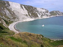
Chalk cliffs, with cliff fall, at the eastern end of Bindon Hill
29:
173:, England. The ridge is formed by the structure known as the
228:
that forms the
Purbeck Hills continues further east on the
60:. Unsourced material may be challenged and removed.
285:, has been closed to the public for use by the
235:The height of the chalk ridge and proximity to
8:
331:(193 m) - sometimes counted as part of the
216:and chalk behind has been eroded, creating
277:Some of the ridge, around the village of
120:Learn how and when to remove this message
375:
138:Looking east along the top of the ridge
7:
58:adding citations to reliable sources
25:
389:Dorset Life - The Dorset Magazine
270:of the 17th century, when it was
34:
45:needs additional citations for
27:Chalk ridge in Dorset, England
383:Chaffey, John (January 2016).
226:ridge of steeply dipping chalk
1:
208:. Where this band ends, at
513:
300:which is managed for its
204:by a band of resistant
147:
139:
340:(168 m), overlooking
145:
137:
446:at dorsetlife.co.uk.
302:calcareous grassland
189:which also includes
54:improve this article
464: /
385:"The Purbeck Hills"
177:, and extends from
329:Creech Barrow Hill
206:Portland limestone
154:, also called the
148:
140:
443:The Purbeck Hills
359:Geology of Dorset
268:English Civil War
175:Purbeck Monocline
162:, are a ridge of
130:
129:
122:
104:
16:(Redirected from
504:
479:
478:
476:
475:
474:
469:
468:50.633°N 2.117°W
465:
462:
461:
460:
457:
429:
428:
426:
424:
406:
400:
399:
397:
395:
380:
317:Nine Barrow Down
256:Nine Barrow Down
125:
118:
114:
111:
105:
103:
62:
38:
30:
21:
512:
511:
507:
506:
505:
503:
502:
501:
497:Isle of Purbeck
492:Hills of Dorset
482:
481:
472:
470:
466:
463:
458:
455:
453:
451:
450:
438:
433:
432:
422:
420:
418:Ordnance Survey
408:
407:
403:
393:
391:
382:
381:
377:
372:
354:Isle of Purbeck
350:
313:
254:sites, such as
191:Salisbury Plain
183:Old Harry Rocks
181:in the west to
126:
115:
109:
106:
69:"Purbeck Hills"
63:
61:
51:
39:
28:
23:
22:
15:
12:
11:
5:
510:
508:
500:
499:
494:
484:
483:
473:50.633; -2.117
448:
447:
437:
436:External links
434:
431:
430:
401:
374:
373:
371:
368:
367:
366:
364:Jurassic Coast
361:
356:
349:
346:
345:
344:
335:
326:
320:
312:
309:
298:nature reserve
295:National Trust
252:archaeological
128:
127:
42:
40:
33:
26:
24:
14:
13:
10:
9:
6:
4:
3:
2:
509:
498:
495:
493:
490:
489:
487:
480:
477:
445:
444:
440:
439:
435:
419:
415:
414:OS GetOutside
411:
405:
402:
390:
386:
379:
376:
369:
365:
362:
360:
357:
355:
352:
351:
347:
343:
342:Lulworth Cove
339:
336:
334:
333:Dorset Heaths
330:
327:
324:
323:Ridgeway Hill
321:
318:
315:
314:
310:
308:
306:
303:
299:
296:
292:
288:
284:
280:
275:
273:
269:
265:
261:
257:
253:
250:
246:
242:
238:
237:Poole Harbour
233:
231:
230:Isle of Wight
227:
223:
219:
215:
211:
210:Durlston Head
207:
203:
200:
196:
192:
188:
184:
180:
179:Lulworth Cove
176:
172:
168:
165:
161:
157:
156:Purbeck Ridge
153:
152:Purbeck Hills
144:
136:
132:
124:
121:
113:
110:February 2024
102:
99:
95:
92:
88:
85:
81:
78:
74:
71: –
70:
66:
65:Find sources:
59:
55:
49:
48:
43:This article
41:
37:
32:
31:
19:
18:Purbeck Ridge
449:
442:
421:. Retrieved
413:
404:
392:. Retrieved
388:
378:
291:Ballard Down
276:
260:Corfe Castle
234:
220:Bay and the
160:the Purbecks
159:
155:
151:
149:
131:
116:
107:
97:
90:
83:
76:
64:
52:Please help
47:verification
44:
471: /
338:Bindon Hill
311:Named hills
195:South Downs
187:Chalk Group
486:Categories
423:3 February
394:3 February
370:References
158:or simply
80:newspapers
348:See also
283:Lulworth
272:slighted
264:medieval
241:Iron Age
193:and the
456:50°38′N
325:(199 m)
319:(199 m)
305:habitat
281:, near
279:Tyneham
202:erosion
199:coastal
94:scholar
459:2°07′W
258:. At
224:. The
222:Solent
212:, the
171:Dorset
96:
89:
82:
75:
67:
293:is a
249:Saxon
245:Roman
218:Poole
167:downs
164:chalk
101:JSTOR
87:books
425:2024
396:2024
287:army
247:and
214:clay
150:The
73:news
169:in
56:by
488::
416:.
412:.
387:.
307:.
274:.
243:,
232:.
427:.
398:.
123:)
117:(
112:)
108:(
98:·
91:·
84:·
77:·
50:.
20:)
Text is available under the Creative Commons Attribution-ShareAlike License. Additional terms may apply.