76:
427:
126:
497:
101:
386:
374:
357:
333:
442:
415:
321:
403:
345:
59:
133:
108:
83:
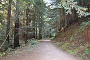
294:, and has over 21 miles (34 km) of trails for hiking, bicycling, and horseback riding. The popular Redwood Trail is wheelchair accessible. Like many parks in California, dogs are not allowed. The preserve is home to many species of animals, including bobcats, mountain lions, coyotes and rabbits.
75:
562:
179:
592:
125:
538:
567:
458:
100:
298:
222:
426:
531:
572:
31:
385:
524:
373:
253:
356:
441:
48:
587:
582:
577:
463:
332:
414:
504:
153:
320:
235:
306:
291:
264:
167:
557:
247:
496:
480:
402:
302:
239:
243:
344:
17:
260:
508:
272:
268:
362:
58:
551:
475:
391:
157:
242:. This 4,471-acre (1,809 ha) preserve was established with a $ 2 million
432:
284:
305:. Parking is available at the main entrance, 4.5 miles (7.2 km) south of
194:
181:
280:
276:
132:
107:
82:
485:
256:
and several of its tributaries flow through the preserve.
259:
The main entrance for the
Purisima Open Space is off the
512:
218:
210:
173:
163:
149:
41:
301:, spanning over 50,000 acres (200 km) in the
476:Openspace.org: Purisima Creek Open Space Preserve
563:Protected areas of San Mateo County, California
459:Midpeninsula Regional Open Space District areas
532:
234:is located on the western slopes of historic
8:
593:San Mateo County, California geography stubs
232:Purisima Creek Redwoods Open Space Preserve
42:Purisima Creek Redwoods Open Space Preserve
539:
525:
38:
568:Midpeninsula Regional Open Space District
299:Midpeninsula Regional Open Space District
223:Midpeninsula Regional Open Space District
316:
297:The Purisima Open Space is part of the
27:Preserve in Woodside, California, U.S.
379:Footbridge along Purisima Creek Trail
7:
493:
491:
148:
267:. The park is notable for its tall
511:. You can help Knowledge (XXG) by
90:Show map of San Francisco Bay Area
25:
18:Purisima Creek Open Space Preserve
495:
440:
425:
413:
401:
384:
372:
355:
343:
331:
319:
131:
124:
106:
99:
81:
74:
57:
51:V (protected landscape/seascape)
271:, along with coastal scrub and
162:
32:Mission La Purísima Concepción
1:
573:Nature reserves in California
447:Tree canopies in the Preserve
140:Show map of the United States
505:San Mateo County, California
154:San Mateo County, California
214:4,711 acres (19.06 km)
609:
490:
29:
420:Another view of the creek
338:Another view of the trail
168:Half Moon Bay, California
68:
56:
46:
486:Save the Redwoods League
248:Save the Redwoods League
63:Redwoods in the preserve
481:Openspace.org: homepage
435:on Purisima Creek Trail
290:The preserve overlooks
507:-related article is a
309:on Skyline Boulevard.
303:San Francisco Bay Area
195:37.43750°N 122.34583°W
115:Show map of California
588:Bay Area Ridge Trail
583:Santa Cruz Mountains
578:Coast redwood groves
464:Coast redwood groves
326:Purisima Creek Trail
240:Woodside, California
200:37.43750; -122.34583
30:For other uses, see
395:(Acer macrophyllum)
366:(Arbutus menziesii)
219:Governing body
191: /
520:
519:
261:Skyline Boulevard
228:
227:
164:Nearest city
16:(Redirected from
600:
541:
534:
527:
499:
492:
444:
429:
417:
405:
388:
376:
359:
347:
335:
323:
273:hardwood forests
269:coastal redwoods
206:
205:
203:
202:
201:
196:
192:
189:
188:
187:
184:
141:
135:
134:
128:
116:
110:
109:
103:
91:
85:
84:
78:
61:
39:
21:
608:
607:
603:
602:
601:
599:
598:
597:
558:IUCN Category V
548:
547:
546:
545:
472:
455:
448:
445:
436:
430:
421:
418:
409:
406:
397:
389:
380:
377:
368:
363:Pacific Madrone
360:
351:
348:
339:
336:
327:
324:
315:
199:
197:
193:
190:
185:
182:
180:
178:
177:
145:
144:
143:
142:
139:
138:
137:
136:
119:
118:
117:
114:
113:
112:
111:
94:
93:
92:
89:
88:
87:
86:
64:
52:
35:
28:
23:
22:
15:
12:
11:
5:
606:
604:
596:
595:
590:
585:
580:
575:
570:
565:
560:
550:
549:
544:
543:
536:
529:
521:
518:
517:
500:
489:
488:
483:
478:
471:
468:
467:
466:
461:
454:
451:
450:
449:
446:
439:
437:
431:
424:
422:
419:
412:
410:
408:Purisima Creek
407:
400:
398:
390:
383:
381:
378:
371:
369:
361:
354:
352:
349:
342:
340:
337:
330:
328:
325:
318:
314:
311:
265:State Route 35
254:Purisima Creek
236:Kings Mountain
226:
225:
220:
216:
215:
212:
208:
207:
175:
171:
170:
165:
161:
160:
151:
147:
146:
130:
129:
123:
122:
121:
120:
105:
104:
98:
97:
96:
95:
80:
79:
73:
72:
71:
70:
69:
66:
65:
62:
54:
53:
47:
44:
43:
26:
24:
14:
13:
10:
9:
6:
4:
3:
2:
605:
594:
591:
589:
586:
584:
581:
579:
576:
574:
571:
569:
566:
564:
561:
559:
556:
555:
553:
542:
537:
535:
530:
528:
523:
522:
516:
514:
510:
506:
501:
498:
494:
487:
484:
482:
479:
477:
474:
473:
469:
465:
462:
460:
457:
456:
452:
443:
438:
434:
428:
423:
416:
411:
404:
399:
396:
393:
392:Bigleaf Maple
387:
382:
375:
370:
367:
364:
358:
353:
346:
341:
334:
329:
322:
317:
313:Photo gallery
312:
310:
308:
304:
300:
295:
293:
292:Half Moon Bay
288:
286:
282:
278:
274:
270:
266:
262:
257:
255:
251:
249:
245:
241:
237:
233:
224:
221:
217:
213:
209:
204:
176:
172:
169:
166:
159:
155:
152:
127:
102:
77:
67:
60:
55:
50:
49:IUCN category
45:
40:
37:
33:
19:
513:expanding it
502:
394:
365:
296:
289:
285:Douglas firs
258:
252:
231:
229:
36:
433:Banana slug
263:section of
198: /
186:122°20′45″W
174:Coordinates
552:Categories
470:References
307:Highway 92
183:37°26′15″N
246:from the
453:See also
281:madrones
150:Location
283:, and
277:tanoak
503:This
350:Vista
509:stub
244:gift
230:The
211:Area
275:of
238:in
158:USA
554::
287:.
279:,
250:.
156:,
540:e
533:t
526:v
515:.
34:.
20:)
Text is available under the Creative Commons Attribution-ShareAlike License. Additional terms may apply.