369:
a period between 1 900 and 1 600 million years ago. The preservation of these un-deformed sandy strata, which include evidence of the first occurrence of free oxygen in the early Earth atmosphere, is due to their having been laid down on a remnant of the stable, primordial
Kaapvaal craton, which has allowed them to remain almost unaltered and subject to little or no regional metamorphism despite their great age. Subsequent uplift of these sediments, collectively named the Waterberg Group, has resulted in their forming today a plateau, elevated in the south by as much as a thousand metres above the surrounding plains. If there were ever younger rocks deposited on top of the Waterberg strata in this region, no evidence remains of the fact. Beneath the thick sedimentary pile lie 2 100 million year-old sedimentary and igneous rocks which elsewhere may be found to host economic deposits of platinum, nickel, iron ore and tin; but no mineral deposits of any economic value have been, or are likely to be discovered in the well-travelled, winnowed Waterberg sediments.
401:
373:
means that most of the rainfall received across the plateau soon runs off rather than contributing to groundwater resources. Thus it is that the
Waterberg is the source of four major perennial rivers, of which the Palala is the largest, all of them flowing eventually northwards into the Limpopo. The other major rivers are the Mogalakwena, the Mokolo and the Matlabas. The acidic nature of the sandstone results in acidic groundwater which leaches nutritious mineral content from the soils, rendering them for the most part low in fertility and poor in carrying capacity. Perhaps counter-intuitively, it is this low nutritive, dystrophic content of the soil that is largely responsible for the extremely high biodiversity that characterises the Waterberg plateau.
397:
preserves badly compared to the red paint that soaks into the rock. Bushman art depicts a variety of antelope, in particular, hartebeest and kudu. The animals are sometimes realistically drawn and on other occasions the creature represented is an imaginative combination of hartebeest or kudu features with human attributes. This is because
Bushman art is a religious expression and the artist was trying to convey beliefs about the spirit world, and experiences during altered states of consciousness by ‘healers’ in the community. The elongated human figures in the art are, for example, designed to explain the stretched feeling that a healer may experience while in trance.
409:
villages and from about the 17th century, stone kraals became prominent features on
Lapalala. The Iron Age farmers had elaborate initiation practices for boys at puberty and groups of boys would be isolated in remote places, like rock shelters, for as long as a month. During this time they would be circumcised and taught cultural beliefs. Amongst these, they would learn about animals representing specific regiments. The boys would then paint these animals on rock faces. They used their fingers dipped in white clay, so their paintings are mere approximations of animals and most often the species cannot be recognised. This ‘farmer’ art preserves badly.
53:
389:
33:
60:
347:, were captured within reaches of the Lapalala Wilderness. A healthy population of male and female fish was found in the river's upper reaches within the Lapalala Wilderness, manifesting normal body mass averaging approximately 1.1 kilograms; moreover, this fish population from the higher reaches of the Palala River was found to be free of
384:
has thirteen known rock art sites, some close to the
Lephalala River, and others near the Blocklands River. Several of the painted sites are in small rock shelters, others on sandstone boulders with smooth surfaces. Two distinct groups peopled the Waterberg in the last 1000 years and both groups were
368:
The rock strata through which the Palala River has incised comprise a substantial sequence, up to 3 000 metres in thickness in places, of fluvial arenaceous sediments derived from an ancient highland several hundred kilometres to the north-east, and deposited in an elongated, fault-bound basin during
408:
The second group of people occupying
Lapalala comprised Bantu-speaking, Iron Age farmers who settled in the valleys where dolerite provided fertile soils for their sorghum and millet crops, and where there was adequate grazing and water for cattle, sheep and goats. These people built semi-permanent
396:
Bushmen, who lived a mobile hunter-gatherer way of life, produced ‘fine-line’, well-drawn art, using brushes made from animal hair, and red and yellow paint from powdered, iron-rich rocks (ochre) mixed with liquids such as water, blood or fat. White paint derived from ash or clay, and this medium
372:
The
Waterberg plateau enjoys generally greater rainfall than is the average for the country as a whole, ranging from over 1000mm in the south to below 400mm in the north. The impermeable nature of the predominant sandstone strata, and its characteristic lack of substantial subterranean aquifers,
412:
People lived in
Lapalala in the Middle Stone Age because stone tools predating 30,000 years ago can be found in several shelters. Thereafter there seems to have been a long gap in occupation and there is presently no evidence that people returned to Lapalala before about 1000 years ago.
355:
damage. The health of the upper reaches was such that the upper Lapala was used in subsequent studies as the healthy control group to compare to other South
African rivers which were more polluted from discharge of untreated
305:
with very clear flowing waters, especially in the uppermost regions; correspondingly biotic health has been assessed as healthy using the North
African catfish as a bio-marker. Interesting
400:
52:
655:
530:
573:
Endoparasites of the sharptooth catfish, Clarias gariepinus (Burchell), from the Rietvlei Dam, Sesmyl Spruit system, South Africa.
429:
of approximately 15,000 square kilometers. Waterberg is the first region in the northern part of South Africa to be named as a
486:
174:
608:
270:
area and considerable additional lands that are important habitat for native wildlife in a zone with considerable ongoing
702:
667:
588:
576:
84:
697:
640:. Cambridge Monographs in African Archaeology 43. BAR International Series 715. Oxford: BAR Publishing.
449:
275:
422:
381:
333:
267:
259:
638:
The Waterberg Plateau in the Northern Province, Republic of South Africa, in the Later Stone Age
651:
526:
430:
481:
278:
community of the upland portion of the Palala River watershed is home to many large African
263:
129:
110:
283:
501:
457:
437:. The extensive rock formation was shaped by hundreds of millions of years of riverine
329:
691:
496:
309:
302:
252:
244:
155:
37:
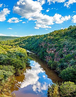
Palala / Lephalala River gorge in Lapalala Wilderness, Waterberg, showing horizontal
545:
465:
388:
337:
248:
100:
340:. In a 2004 study of the river's health, specimens of the North African catfish,
291:
140:
612:
680:
306:
189:
176:
461:
38:
32:
453:
445:
348:
271:
159:
491:
438:
342:
287:
434:
426:
357:
279:
238:
469:
442:
399:
387:
352:
321:
295:
312:
exist on bluffs along the river in the Lapalala Wilderness area.
325:
392:"Lapalala farmer art" at Lapalala Wilderness in South Africa.
668:
Palala River water quality and biota studies: site selection
404:"Lapalala hartebeest" at Lapalala Wilderness in South Africa
251:. This river's catchment basin is a sub-watershed of the
546:
Major rivers and streams within the Limpopo River Basin
525:. Tafelberg-uitgewers, Cape Town. pp. 301, 302.
589:
University of Johannesburg Palala River analysis of
215:
205:
166:
149:
139:
125:
116:
106:
96:
91:
75:
21:
650:, Protea Boekhuis; First Edition (April 7, 2020),
602:C.Michael Hogan, Mark L. Cooke and Helen Murray,
360:and agricultural wastes within their watersheds.
301:The Palala River has been shown to exhibit high
561:. Van Riebeeck Society, Cape Town. p. 162.
559:Journal of Residence in Africa by Thomas Baines
421:Much of the Palala River course is through the
385:responsible for the art in Lapalala's reserve.
8:
448:. The ecosystem can be characterised as a
324:that inhabit the Palala River including
673:
513:
258:It is a significant watercourse in the
16:River in Limpopo Province, South Africa
18:
606:, Lumina Technologies, May 22, 2006.
219:4,868 km (1,880 sq mi)
67:Location of the Lephalala River mouth
7:
87:), which means "one that inundates".
59:
523:Suid-Afrikaanse berg- en riviername
14:
456:. Within the Waterberg there are
274:restoration. The predominantly
58:
51:
31:
468:finds related to the origin of
266:. The river drains much of the
487:List of rivers of South Africa
168: • coordinates
1:
117:Physical characteristics
207: • elevation
636:Van der Ryst, M.M. (1998).
441:to yield diverse bluff and
151: • location
719:
577:University of Johannesburg
377:Prehistoric rock paintings
211:788 m (2,585 ft)
521:du Plessis, E.J. (1973).
223:
135:
121:
46:
30:
604:The Waterberg Biosphere
557:Kennedy, R.F. (1964) .
464:, and nearby are early
320:There are a variety of
405:
393:
403:
391:
364:Geology and hydrology
190:23.08389°S 27.89444°E
460:finds dating to the
450:dry deciduous forest
276:dry deciduous forest
646:Wadley, R. (2020).
423:Waterberg Biosphere
334:African Rock Python
268:Lapalala Wilderness
195:-23.08389; 27.89444
186: /
575:, Masters thesis,
406:
394:
237:, also called the
79:Name derived from
703:Rivers of Limpopo
431:Biosphere Reserve
351:and also free of
227:
226:
710:
683:
678:
648:Waterberg Echoes
624:
623:
621:
620:
611:. Archived from
600:
594:
586:
580:
571:Maxwell Barson,
569:
563:
562:
554:
548:
543:
537:
536:
518:
482:Drainage basin A
417:Waterberg Massif
264:Limpopo Province
247:, is a river in
201:
200:
198:
197:
196:
191:
187:
184:
183:
182:
179:
130:Waterberg Massif
111:Limpopo Province
62:
61:
55:
35:
19:
718:
717:
713:
712:
711:
709:
708:
707:
688:
687:
686:
679:
675:
664:
633:
628:
627:
618:
616:
607:
601:
597:
587:
583:
570:
566:
556:
555:
551:
544:
540:
533:
520:
519:
515:
510:
478:
419:
379:
366:
318:
284:Blue Wildebeest
235:Lephalala River
208:
194:
192:
188:
185:
180:
177:
175:
173:
172:
169:
158:, South Africa/
152:
71:
70:
69:
68:
65:
64:
63:
42:
26:
23:
22:Lephalala River
17:
12:
11:
5:
716:
714:
706:
705:
700:
690:
689:
685:
684:
672:
671:
670:
663:
662:External links
660:
659:
658:
656:978-1485309352
644:
641:
632:
629:
626:
625:
595:
581:
564:
549:
538:
531:
512:
511:
509:
506:
505:
504:
502:Nile crocodile
499:
494:
489:
484:
477:
474:
458:archaeological
418:
415:
378:
375:
365:
362:
330:Nile crocodile
317:
314:
310:rock paintings
240:Rhooebok-river
225:
224:
221:
220:
217:
213:
212:
209:
206:
203:
202:
170:
167:
164:
163:
153:
150:
147:
146:
143:
137:
136:
133:
132:
127:
123:
122:
119:
118:
114:
113:
108:
104:
103:
98:
94:
93:
89:
88:
77:
73:
72:
66:
57:
56:
50:
49:
48:
47:
44:
43:
36:
28:
27:
24:
15:
13:
10:
9:
6:
4:
3:
2:
715:
704:
701:
699:
696:
695:
693:
682:
677:
674:
669:
666:
665:
661:
657:
653:
649:
645:
642:
639:
635:
634:
630:
615:on 2012-03-01
614:
610:
605:
599:
596:
593:
592:
591:C. Gariepinus
585:
582:
578:
574:
568:
565:
560:
553:
550:
547:
542:
539:
534:
532:0-624-00273-X
528:
524:
517:
514:
507:
503:
500:
498:
497:Rock painting
495:
493:
490:
488:
485:
483:
480:
479:
475:
473:
471:
467:
463:
459:
455:
451:
447:
444:
440:
436:
432:
428:
424:
416:
414:
410:
402:
398:
390:
386:
383:
376:
374:
370:
363:
361:
359:
354:
350:
346:
344:
339:
335:
331:
327:
323:
315:
313:
311:
308:
304:
303:water quality
299:
297:
294:and numerous
293:
289:
285:
281:
277:
273:
269:
265:
261:
256:
254:
253:Limpopo River
250:
246:
245:Thomas Baines
242:
241:
236:
232:
222:
218:
214:
210:
204:
199:
171:
165:
161:
157:
156:Limpopo River
154:
148:
144:
142:
138:
134:
131:
128:
124:
120:
115:
112:
109:
105:
102:
99:
95:
90:
86:
82:
78:
74:
54:
45:
40:
34:
29:
20:
698:Palala River
676:
647:
637:
617:. Retrieved
613:the original
603:
598:
590:
584:
572:
567:
558:
552:
541:
522:
516:
466:evolutionary
420:
411:
407:
395:
380:
371:
367:
341:
338:hippopotamus
319:
300:
257:
249:South Africa
239:
234:
230:
228:
101:South Africa
80:
25:Palala River
316:River biota
307:prehistoric
292:White Rhino
193: /
692:Categories
681:Lyn Wadley
643:Wadley, L.
619:2010-06-10
508:References
345:gariepinus
282:including
216:Basin size
181:27°53′40″E
462:Stone Age
349:parasites
260:Waterberg
81:Lephalale
76:Etymology
39:sandstone
476:See also
454:Bushveld
446:landform
382:Lapalala
272:bushveld
262:area of
178:23°5′2″S
160:Botswana
92:Location
41:layering
631:Sources
609:"Lumaw"
492:Bushmen
439:erosion
343:Clarias
288:Giraffe
280:mammals
97:Country
654:
579:(2004)
529:
470:humans
435:UNESCO
427:massif
358:sewage
296:bovids
231:Palala
162:border
145:
126:Source
443:butte
353:liver
322:fauna
141:Mouth
107:State
85:Sotho
652:ISBN
527:ISBN
425:, a
336:and
326:fish
229:The
452:or
433:by
243:by
233:or
694::
472:.
332:,
328:,
298:.
290:,
286:,
255:.
622:.
535:.
83:(
Text is available under the Creative Commons Attribution-ShareAlike License. Additional terms may apply.