38:
403:
91:
55:
920:
900:
646:
98:
62:
426:
in 1526he good times Pata becamse part of Šintava dominion. In 1820 the classicistic Church of
Nativity of Virgin Mary was built. It is simple building built mostly by local citizens funds. Brincks were provided by landlord of Šintava. In revolution year 1849 a battle between Habsburg army and
983:
37:
689:
964:
988:
126:
601:
54:
90:
650:
402:
682:
286:
957:
662:
778:
428:
258:
535:
883:
563:
503:
475:
675:
950:
383:
276:
773:
868:
422:. In medieval times, Pata was prosperous village with church, Pata was settled by little nobles. After the
878:
930:
237:
343:
247:
823:
423:
863:
347:
440:
311:
919:
758:
725:
798:
597:
934:
699:
355:
339:
327:
179:
873:
843:
788:
432:
803:
768:
753:
748:
351:
888:
828:
743:
738:
663:
https://web.archive.org/web/20070513023228/http://www.statistics.sk/mosmis/eng/run.html
444:
977:
927:
818:
667:
436:
367:
331:
169:
75:
838:
617:
455:, after War again part of Czechoslovakia. Nowadays, Pata is middle sized village of
435:
era. Before the establishment of independent
Czechoslovakia in 1918, it was part of
359:
452:
448:
323:
848:
793:
504:"Hustota obyvateľstva - obce [om7014rr_ukaz: Rozloha (Štvorcový meter)]"
858:
833:
808:
733:
419:
371:
431:
took place nearby Pata. Event is commemorated by obelisk called
Oloment from
141:
128:
228:
763:
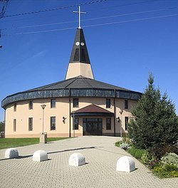
459:. In 21st century new, modern Church of Nativity of Virgin Mary was built.
375:
645:
899:
718:
456:
379:
335:
406:
Old Church of
Nativity of Virgin Mary, with Chapel of Mary in foreground
853:
711:
415:
411:
319:
387:
254:
233:
363:
783:
570:(in Slovak). Statistical Office of the Slovak Republic. 2022-03-31
542:(in Slovak). Statistical Office of the Slovak Republic. 2015-04-17
510:(in Slovak). Statistical Office of the Slovak Republic. 2022-03-31
482:(in Slovak). Statistical Office of the Slovak Republic. 2022-03-31
401:
391:
418:
was first mentioned in 1156, but local settlement is known since
671:
358:
watercourse flows through the village. Nearby villages are
350:. The area consists of a mild upland and a shallow valley
657:
299:
938:
295:
285:
275:
265:
244:
227:
219:
214:
206:
198:
193:
185:
175:
165:
157:
21:
476:"Počet obyvateľov podľa pohlavia - obce (ročne)"
984:Villages and municipalities in Galanta District
958:
683:
8:
530:
528:
526:
524:
965:
951:
690:
676:
668:
443:. After 1918 the village become a part of
378:. Pata lies 9 kilometres far from city of
18:
467:
294:
284:
264:
226:
213:
205:
192:
184:
156:
121:
46:
34:
498:
496:
338:. The village lies in central part of
274:
243:
218:
197:
174:
164:
7:
916:
914:
558:
556:
202:17.54 km (6.77 sq mi)
937:. You can help Knowledge (XXG) by
14:
42:Church of Nativity of Virgin Mary
918:
898:
644:
96:
89:
60:
53:
36:
620:[Characteric of Pata].
382:. Village is situated close to
596:] (in Slovak). Obec Pata.
1:
989:Trnava Region geography stubs
564:"Hustota obyvateľstva - obce"
588:Klobučník, Miroslav (2008).
97:
61:
618:"Charakteristika obce Pata"
346:) and in east–west part of
1005:
913:
536:"Základná charakteristika"
895:
706:
624:. Obec Pata. Feb 12, 2015
122:
80:Show map of Trnava Region
47:
35:
28:
594:From the History of Pata
451:Pata was part of puppet
210:138 m (453 ft)
74:Location of Pata in the
16:Municipality in Slovakia
651:Pata, Galanta District
407:
315:
653:at Wikimedia Commons
405:
246: • Summer (
113:Show map of Slovakia
879:Vinohrady nad Váhom
138: /
698:Municipalities of
441:Kingdom of Hungary
412:historical records
408:
220: • Total
199: • Total
946:
945:
908:
907:
649:Media related to
603:978-80-969826-5-3
590:Z dejín obce Pata
568:www.statistics.sk
540:www.statistics.sk
508:www.statistics.sk
480:www.statistics.sk
305:
304:
142:48.283°N 17.833°E
996:
967:
960:
953:
922:
915:
903:
902:
700:Galanta District
692:
685:
678:
669:
648:
634:
633:
631:
629:
614:
608:
607:
585:
579:
578:
576:
575:
560:
551:
550:
548:
547:
532:
519:
518:
516:
515:
500:
491:
490:
488:
487:
472:
424:Battle of Mohács
386:, which connect
342:(in part called
340:Danubian Lowland
328:Galanta District
251:
153:
152:
150:
149:
148:
143:
139:
136:
135:
134:
131:
114:
100:
99:
93:
81:
64:
63:
57:
40:
19:
1004:
1003:
999:
998:
997:
995:
994:
993:
974:
973:
972:
971:
911:
909:
904:
897:
893:
702:
696:
642:
637:
627:
625:
622:www.obecpata.sk
616:
615:
611:
604:
587:
586:
582:
573:
571:
562:
561:
554:
545:
543:
534:
533:
522:
513:
511:
502:
501:
494:
485:
483:
474:
473:
469:
465:
433:Austria-Hungary
400:
344:Danubian Upland
300:www.obecpata.sk
271:
245:
186:First mentioned
146:
144:
140:
137:
132:
129:
127:
125:
124:
118:
117:
116:
115:
112:
111:
110:Pata (Slovakia)
108:
107:
106:
105:
101:
84:
83:
82:
79:
78:
72:
71:
70:
69:
65:
43:
31:
24:
17:
12:
11:
5:
1002:
1000:
992:
991:
986:
976:
975:
970:
969:
962:
955:
947:
944:
943:
923:
906:
905:
896:
894:
892:
891:
889:Zemianske Sady
886:
881:
876:
871:
866:
861:
856:
851:
846:
841:
836:
831:
826:
821:
816:
811:
806:
801:
796:
791:
786:
781:
776:
771:
766:
761:
756:
751:
746:
741:
736:
730:
729:
722:
715:
707:
704:
703:
697:
695:
694:
687:
680:
672:
666:
665:
660:
641:
640:External links
638:
636:
635:
609:
602:
580:
552:
520:
492:
466:
464:
461:
445:Czechoslovakia
429:Hungarian army
420:prehistory age
399:
396:
334:of south-west
303:
302:
297:
293:
292:
289:
283:
282:
279:
273:
272:
269:
267:
263:
262:
252:
242:
241:
231:
225:
224:
221:
217:
216:
212:
211:
208:
204:
203:
200:
196:
195:
191:
190:
187:
183:
182:
177:
173:
172:
167:
163:
162:
159:
155:
154:
147:48.283; 17.833
120:
119:
109:
103:
102:
95:
94:
88:
87:
86:
85:
73:
67:
66:
59:
58:
52:
51:
50:
49:
48:
45:
44:
41:
33:
32:
29:
26:
25:
22:
15:
13:
10:
9:
6:
4:
3:
2:
1001:
990:
987:
985:
982:
981:
979:
968:
963:
961:
956:
954:
949:
948:
942:
940:
936:
933:article is a
932:
929:
928:Trnava Region
924:
921:
917:
912:
901:
890:
887:
885:
882:
880:
877:
875:
872:
870:
867:
865:
862:
860:
857:
855:
852:
850:
847:
845:
842:
840:
837:
835:
832:
830:
827:
825:
822:
820:
817:
815:
812:
810:
807:
805:
802:
800:
797:
795:
792:
790:
787:
785:
782:
780:
777:
775:
772:
770:
767:
765:
762:
760:
757:
755:
752:
750:
747:
745:
742:
740:
737:
735:
732:
731:
728:
727:
723:
721:
720:
716:
714:
713:
709:
708:
705:
701:
693:
688:
686:
681:
679:
674:
673:
670:
664:
661:
659:
658:Official page
656:
655:
654:
652:
647:
639:
623:
619:
613:
610:
605:
599:
595:
591:
584:
581:
569:
565:
559:
557:
553:
541:
537:
531:
529:
527:
525:
521:
509:
505:
499:
497:
493:
481:
477:
471:
468:
462:
460:
458:
454:
450:
446:
442:
438:
437:Nyitra County
434:
430:
425:
421:
417:
413:
404:
397:
395:
393:
389:
385:
384:R1 expressway
381:
377:
373:
369:
365:
361:
357:
353:
349:
345:
341:
337:
333:
332:Trnava Region
329:
325:
321:
317:
313:
309:
301:
298:
290:
288:
280:
278:
268:
260:
256:
253:
249:
239:
235:
232:
230:
222:
209:
201:
188:
181:
178:
171:
168:
160:
151:
123:Coordinates:
92:
77:
76:Trnava Region
56:
39:
27:
20:
939:expanding it
925:
910:
813:
769:Horné Saliby
759:Dolný Chotár
754:Dolné Saliby
749:Dolná Streda
726:Sládkovičovo
724:
717:
710:
643:
626:. Retrieved
621:
612:
593:
589:
583:
572:. Retrieved
567:
544:. Retrieved
539:
512:. Retrieved
507:
484:. Retrieved
479:
470:
453:Slovak state
449:World War II
409:
348:Nitra Upland
324:municipality
307:
306:
281:+421 31
30:Municipality
869:Veľké Úľany
824:Pusté Úľany
799:Kráľov Brod
744:Čierny Brod
739:Čierna Voda
439:within the
270:925 53
266:Postal code
145: /
978:Categories
874:Veľký Grob
864:Veľká Mača
844:Tomášikovo
819:Pusté Sady
574:2022-03-31
546:2022-03-31
514:2022-03-31
486:2022-03-31
463:References
368:Pusté Sady
215:Population
931:geography
849:Topoľnica
804:Matúškovo
447:. During
312:Hungarian
287:Car plate
277:Area code
229:Time zone
207:Elevation
884:Vozokany
829:Šalgočka
457:Slovakia
336:Slovakia
330:of the
316:Vágpatta
176:District
161:Slovakia
859:Váhovce
854:Trstice
839:Šoporňa
834:Šintava
809:Mostová
779:Jánovce
734:Abrahám
712:Galanta
416:village
398:History
372:Šintava
360:Šoporňa
320:village
318:) is a
296:Website
180:Galanta
158:Country
133:17°50′E
130:48°17′N
794:Košúty
628:Feb 1,
600:
388:Trnava
376:Hájske
356:Jarčie
354:. The
170:Trnava
166:Region
926:This
789:Kajal
784:Jelka
774:Hoste
719:Sereď
592:[
392:Nitra
380:Sereď
255:UTC+2
234:UTC+1
223:3,241
935:stub
814:Pata
630:2020
598:ISBN
414:the
390:and
322:and
308:Pata
259:CEST
194:Area
189:1156
104:Pata
68:Pata
23:Pata
764:Gáň
410:In
364:Báb
352:Jác
326:in
248:DST
238:CET
980::
566:.
555:^
538:.
523:^
506:.
495:^
478:.
394:.
374:a
370:,
366:,
362:,
314::
291:GA
966:e
959:t
952:v
941:.
691:e
684:t
677:v
632:.
606:.
577:.
549:.
517:.
489:.
310:(
261:)
257:(
250:)
240:)
236:(
Text is available under the Creative Commons Attribution-ShareAlike License. Additional terms may apply.