36:
182:
Prior to 1946, the arable land west of
Pyongyang alongside the river (the flood plain), down to where it entered the Taedong River was subject to annual flooding. This area was known as
386:
148:
There are several bridges across the river in
Pyongyang, including one at its mouth called the "Pothong Bridge"; however, the largest is the one known as "Ansan Bridge",
201:
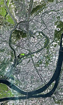
In 1971, in a park on Mount
Bonghwa, a hill on the left (east) bank of the river, the government erected a monument for the "Pothong River Improvement Project",
299:
The Ansan Bridge appears on a 1990 stamp, Scott #2891, label in that catalogue as "Pothong Bridge" - Scott (2008) "Korea, Democratic People’s
Republic"
186:. The farmers there annually rebuilt their homes after the floods subsided, so the construction was, perforce, of a temporary nature, huts and even
352:
376:
312:
284:
403:
251:. In 1998, they issued a stamp souvenir sheet showing Kim Il Sung breaking ground for the construction of the channelization project.
527:
522:
88:
327:
483:
204:
151:
244:
532:
102:
348:
440:
427:
395:
372:
308:
280:
276:
20:
331:
304:
475:
516:
142:
233:
134:
324:
498:
485:
219:
206:
166:
153:
399:
351:[The Banks of the Potong River] (in German). Nordkorea-Information.
187:
138:
35:
93:
78:
75:
72:
48:
64:
247:(DPRK) issued a stamp commemorating Kim Il Sung's 1945 visit to
19:"Potonggang" redirects here. For the district of Pyongyang, see
476:
Photo of monument with downtown
Pyongyang in the background
369:
Pyongyang: The Hidden
History of the North Korean Capital
107:
179:, which supports the main east–west divided highway.
301:
Scott 2009 Standard
Postage Stamp Catalogue Volume 4
101:
87:
63:
47:
42:
394:. Pyongyang: Foreign Languages Publishing House.
8:
343:
341:
339:
325:http://www.pyongyang-metro.com/pystrtmp.jpeg
194:as the "Pothong River Improvement Project".
190:. In 1946 the river was channelized through
70:
54:
462:Scott #3790 - Scott (2008), page 326.
453:Scott #1533 - Scott (2008), page 276.
266:
264:
34:
388:Kim Il Sung: The Great Man of the Century
365:Some authors referred to it as a slum.
260:
25:
355:from the original on 19 January 2016.
7:
349:"Ufergebiet des Flusses Pothonggang"
441:"Pothong River Improvement Project"
273:Historical Dictionary of Pyongyang
14:
426:The park is sometimes known as "
275:. London: Anthem Press. p.
307:, Sidney, Ohio, page 303.
137:. It flows through the capital
71:
55:
1:
240:and the 1946 channelization.
428:Potong River Pleasure Ground
245:North Korean postal service
108:
94:
549:
198:is now part of Pyongyang.
141:and is a tributary of the
18:
271:Corfield, Justin (2014).
33:
28:
443:. Geoview (Lutz Harder).
371:. Budapest: Entente Bt.
367:Springer, Chris (2003).
528:Geography of Pyongyang
499:37.00194°N 125.69833°E
385:Han, Myŏng-ho (1994).
220:39.04389°N 125.70944°E
167:39.03389°N 125.70417°E
523:Rivers of North Korea
305:Scott Publishing Co.
255:Notes and references
89:Revised Romanization
16:River in North Korea
504:37.00194; 125.69833
495: /
225:39.04389; 125.70944
216: /
172:39.03389; 125.70417
163: /
330:2016-03-05 at the
232:. It commemorates
378:978-963-00-8104-7
313:978-0-89487-420-8
286:978-1-78308-341-1
236:'s 1945 visit to
115:
114:
103:McCune–Reischauer
540:
510:
509:
507:
506:
505:
500:
496:
493:
492:
491:
488:
463:
460:
454:
451:
445:
444:
437:
431:
424:
418:
417:
415:
414:
408:
402:. Archived from
393:
382:
363:
357:
356:
345:
334:
321:
315:
303:(165th edition)
297:
291:
290:
268:
231:
230:
228:
227:
226:
221:
217:
214:
213:
212:
209:
178:
177:
175:
174:
173:
168:
164:
161:
160:
159:
156:
133:) is a river in
111:
97:
82:
81:
58:
57:
38:
26:
21:Potonggang-guyok
548:
547:
543:
542:
541:
539:
538:
537:
513:
512:
503:
501:
497:
494:
489:
486:
484:
482:
481:
472:
467:
466:
461:
457:
452:
448:
439:
438:
434:
425:
421:
412:
410:
406:
391:
384:
379:
366:
364:
360:
347:
346:
337:
332:Wayback Machine
322:
318:
298:
294:
287:
270:
269:
262:
257:
224:
222:
218:
215:
210:
207:
205:
203:
202:
171:
169:
165:
162:
157:
154:
152:
150:
149:
83:
59:
24:
17:
12:
11:
5:
546:
544:
536:
535:
530:
525:
515:
514:
479:
478:
471:
470:External links
468:
465:
464:
455:
446:
432:
419:
377:
358:
335:
316:
292:
285:
259:
258:
256:
253:
113:
112:
105:
99:
98:
91:
85:
84:
69:
67:
61:
60:
53:
51:
45:
44:
40:
39:
31:
30:
15:
13:
10:
9:
6:
4:
3:
2:
545:
534:
533:South Pyongan
531:
529:
526:
524:
521:
520:
518:
511:
508:
477:
474:
473:
469:
459:
456:
450:
447:
442:
436:
433:
429:
423:
420:
409:on 2016-03-29
405:
401:
397:
390:
389:
380:
374:
370:
362:
359:
354:
350:
344:
342:
340:
336:
333:
329:
326:
320:
317:
314:
310:
306:
302:
296:
293:
288:
282:
278:
274:
267:
265:
261:
254:
252:
250:
246:
241:
239:
235:
229:
199:
197:
193:
189:
185:
180:
176:
146:
144:
143:Taedong River
140:
136:
132:
128:
124:
123:Pot'ong River
120:
119:Pothong River
110:
106:
104:
100:
96:
92:
90:
86:
80:
77:
74:
68:
66:
62:
52:
50:
46:
41:
37:
32:
29:Pothong River
27:
22:
480:
458:
449:
435:
422:
411:. Retrieved
404:the original
387:
368:
361:
319:
300:
295:
272:
248:
243:In 1976 the
242:
237:
200:
195:
191:
183:
181:
147:
130:
126:
122:
118:
116:
109:Pot'ong-gang
502: /
490:125°41′54″E
323:See map at
234:Kim Il Sung
223: /
211:125°42′34″E
170: /
158:125°42′15″E
135:North Korea
95:Botong-gang
43:Korean name
517:Categories
487:37°00′07″N
413:2016-03-29
249:Tosongrang
238:Tosongrang
208:39°02′38″N
196:Tosongrang
192:Tosongrang
188:pit-houses
184:Tosongrang
155:39°02′02″N
127:Potonggang
49:Chosŏn'gŭl
139:Pyongyang
400:30886237
353:Archived
328:Archived
398:
375:
311:
283:
131:Potong
65:Hancha
407:(PDF)
392:(PDF)
396:OCLC
373:ISBN
309:ISBN
281:ISBN
117:The
277:167
129:or
56:보통강
519::
430:".
383:;
338:^
279:.
263:^
145:.
125:,
416:.
381:.
289:.
121:(
79:江
76:通
73:普
23:.
Text is available under the Creative Commons Attribution-ShareAlike License. Additional terms may apply.