27:
2031:
175:
28:
369:. Shipping traffic into Escanaba immediately increased, which also increased the traffic through the relatively narrow Poverty Island Passage near the southern shore of Poverty island. The Poverty Island Passage was hazardous to traverse after dark, so in 1867 the Lighthouse Board requested funds to build a lighthouse on the southern tip of Poverty Island. However, Congress did not appropriate funds, some $ 18,000, until 1873.
2042:
38:
806:
372:
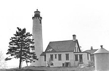
Work on the light began the same year; however a late season fire destroyed some of the building material stored near the partially completed lighthouse. Work continued in 1874, but the tower was only partially completed before funds ran out. A temporary light was installed. After an additional $
380:
In 1885, a fog signal station was constructed nearby. In 1894, an iron oil house and docks were constructed. The light was automated in 1957 and the buildings abandoned. The light was deactivated in 1976 after another light was installed in a skeletal steel tower nearby. The cast iron lantern was
1920:
2015:
1951:
1935:
1925:
2076:
2086:
2010:
1956:
1597:
1977:
1879:
1910:
1844:
1809:
1884:
1789:
1749:
1574:
1849:
1839:
1834:
1814:
1930:
1764:
1679:
2081:
1799:
1794:
1669:
1889:
1854:
1759:
1734:
381:
removed from the tower and discarded nearby along with other lighthouse equipment. In the 1980s the lantern was rescued by the Delta County
Historical Society, who used it to refurbish the
1874:
1824:
1804:
1779:
1769:
1754:
1744:
1729:
1709:
1684:
1674:
1664:
403:. The tower is 70 feet (21 m) high, with the light installed in a cast-iron lantern at 65 feet (20 m) above the ground. A wood frame and brick keeper's quarters is attached.
1894:
1869:
1774:
1714:
1694:
1689:
1659:
1649:
1829:
1784:
1724:
1699:
1654:
1961:
1859:
1739:
1704:
1915:
1864:
1819:
1719:
680:
1627:
1612:
551:
1567:
1643:
587:
2045:
1560:
1179:
1174:
75:
2035:
1340:
1059:
911:
606:
1607:
1535:
2066:
1527:
1064:
942:
937:
580:
1583:
755:
670:
504:
342:
255:
1039:
1998:
1506:
2071:
1134:
1501:
830:
573:
1511:
1370:
1169:
952:
845:
665:
635:
596:
1426:
1421:
1330:
1144:
1139:
740:
1436:
1431:
1275:
1491:
1441:
1300:
1365:
983:
825:
705:
289:
68:
1230:
745:
1194:
1054:
710:
1360:
916:
921:
2003:
1982:
1481:
1386:
1014:
988:
725:
720:
1456:
1250:
1124:
1049:
835:
730:
685:
1119:
1355:
1310:
1104:
1089:
1019:
978:
775:
675:
660:
650:
1466:
1406:
896:
373:
3,000 was appropriated, the light station was completed in 1875. The permanent light, with its fourth order
1215:
993:
880:
850:
780:
690:
282:
1446:
1285:
1617:
1295:
1290:
1270:
1245:
1159:
1109:
715:
625:
1461:
1396:
1622:
1602:
1094:
1024:
855:
795:
509:
278:
1496:
1486:
1476:
1471:
1325:
1029:
1391:
1034:
1411:
1345:
1335:
1260:
1255:
1225:
1220:
1084:
1079:
1069:
973:
906:
840:
750:
400:
174:
1416:
1280:
1235:
1129:
1114:
785:
630:
1401:
552:"A Drone Flew High Above An Uninhabited Island In Michigan And Caught The Most Incredible Footage"
1320:
1265:
1240:
1154:
1149:
998:
947:
875:
790:
765:
695:
645:
362:
358:
1350:
1315:
1189:
1184:
1164:
901:
820:
760:
700:
655:
640:
387:
529:
447:
1552:
1074:
968:
870:
865:
770:
382:
338:
61:
1451:
1099:
1044:
735:
366:
1305:
620:
365:
was completed, allowing iron ore to be easily transported to the southern shore of the
330:
53:
305:
2060:
334:
57:
2016:
University and college buildings listed on the
National Register of Historic Places
1210:
374:
220:
477:. Narional Park Service Inventory of Historic Light Stations: Michigan Lighthouses
474:
37:
1540:
90:
77:
805:
385:
in
Escanaba. The lighthouse remains abandoned, and in 2011 was declared by
565:
2011:
List of jails and prisons on the
National Register of Historic Places
399:
The
Poverty Island Light was designed to be a near duplicate of the
2077:
Lighthouses on the
National Register of Historic Places in Michigan
499:
1556:
569:
2087:
National
Register of Historic Places in Delta County, Michigan
171:
National
Register of Historic Places listed place
1991:
1970:
1944:
1903:
1636:
1613:
History of the
National Register of Historic Places
1590:
1520:
1379:
1203:
1007:
961:
930:
889:
813:
613:
311:
298:
288:
274:
266:
226:
215:
207:
199:
191:
186:
167:
159:
151:
143:
135:
127:
119:
111:
106:
67:
48:
2082:Buildings and structures in Delta County, Michigan
1644:List of U.S. National Historic Landmarks by state
1507:Vidal Shoals Channel Range Front and Rear Lights
2036:National Register of Historic Places portal
391:to be "America’s Most Endangered Lighthouse."
1568:
581:
230:14 nautical miles; 26 kilometres (16 mi)
8:
22:
528:Timothy Harrison (September–October 2011),
1575:
1561:
1553:
1512:Windmill Point Range Front and Rear Lights
1341:St. Clair Flats Front and Rear Range Light
588:
574:
566:
173:
36:
21:
16:Lighthouse in Lake Michigan, United States
1584:U.S. National Register of Historic Places
953:Rouleau Point Range Front and Rear Lights
357:In 1864, the railroad connection between
256:U.S. National Register of Historic Places
1427:Grassy Island South Channel Range Lights
1422:Grassy Island North Channel Range Lights
607:List of lighthouses in the United States
523:
521:
519:
1536:List of lifesaving stations in Michigan
412:
294:Light Stations of the United States MPS
60:, 5.8 miles (9.3 km) south of the
530:"America's Most Endangered Lighthouse"
500:"National Register Information System"
494:
492:
442:
440:
438:
436:
377:, was finally lit on August 10, 1875.
1437:Grosse Ile South Channel Range Lights
1432:Grosse Ile North Channel Range Lights
912:Round Island Light (St. Mary's River)
469:
467:
465:
434:
432:
430:
428:
426:
424:
422:
420:
418:
416:
7:
756:Presque Isle Harbor Breakwater Light
505:National Register of Historic Places
343:National Register of Historic Places
1060:Grand Haven South Pierhead Entrance
550:Boudreau, Sophie (April 14, 2020).
337:, 5.8 miles (9.3 km) south of
1999:National Historic Preservation Act
1502:St. Mary's River Lower Range Front
14:
2041:
2040:
2029:
1065:Grand Haven South Pierhead Inner
943:Keweenaw Waterway Upper Entrance
938:Keweenaw Waterway Lower Entrance
804:
741:Ontonagon Harbor West Breakwater
26:
1361:Tri-Centennial Light of Detroit
1952:Federated States of Micronesia
1598:Architectural style categories
1492:Sand Beach North Entrance East
1442:Harwood Point East Range Front
671:Grand Island Harbor Rear Range
300:
1:
2067:Lighthouses completed in 1875
1543:, Musselman Island lighthouse
1366:William Livingstone Memorial
347:Poverty Island Light Station
329:is a light house located on
248:Poverty Island Light Station
23:Poverty Island Light Station
1231:Cheboygan River Front Range
1180:St. Joseph North Pier Outer
1175:St. Joseph North Pier Inner
746:Portage River (Jacobsville)
448:"Poverty Island Lighthouse"
2103:
2004:Historic Preservation Fund
1983:American Legation, Morocco
1055:Grand Haven North Pierhead
831:Manistique East Breakwater
711:Marquette Breakwater Outer
270:171.2 acres (69.3 ha)
2024:
1945:Lists by associated state
917:Six Mile Point Range Rear
802:
776:Sand Point Light (Baraga)
681:Grand Marais Range Lights
666:Grand Island East Channel
651:Eagle Harbor Range Lights
636:Copper Harbor Front Range
603:
319:
299:NRHP reference
262:
253:
246:
242:
238:
234:
182:
44:
35:
2072:Houses completed in 1875
1926:Northern Mariana Islands
1380:Historical (lost) lights
1331:Saginaw River Rear Range
1145:Pentwater South Pierhead
1140:Pentwater North Pierhead
931:Portage River/Ship Canal
922:Winter Point Range Front
814:Southern Upper Peninsula
614:Northern Upper Peninsula
341:. It was listed on the
1387:Au Sable North Pierhead
1301:Peche Island Rear Range
1204:Eastern Lower Peninsula
1008:Western Lower Peninsula
597:Lighthouses in Michigan
283:U.S. Lighthouse Service
1921:Minor Outlying Islands
1904:Lists by insular areas
1618:Keeper of the Register
475:"Poverty Island Light"
1623:National Park Service
1603:Contributing property
1457:Mama Juda Range Front
1050:Frankfort South Range
1040:Charlevoix South Pier
510:National Park Service
279:U.S. Lighthouse Board
91:45.52722°N 86.66361°W
1978:District of Columbia
1482:North Manitou Island
1170:South Manitou Island
1120:Mission Point (1933)
1015:Beaver Island Harbor
989:Round Island Passage
726:Munising Front Range
721:Mendota (Bete Grise)
401:Sturgeon Point Light
327:Poverty Island Light
1251:Fourteen Foot Shoal
1135:North Manitou Shoal
1125:Muskegon Breakwater
962:Straits of Mackinac
731:Munising Rear Range
661:Fourteen Mile Point
211:78 feet (24 m)
147:65 feet (20 m)
96:45.52722; -86.66361
87: /
32:
1467:Middle Lake George
1356:Thunder Bay Island
1311:Pointe aux Barques
1090:Little Sable Point
1020:Beaver Island Head
979:Old Mackinac Point
791:Thunder Bay Island
676:Grand Island North
559:Only in your state
450:. Seeing The Light
2054:
2053:
1608:Historic district
1550:
1549:
1407:Ecorse Range Rear
1276:Mariners Memorial
1105:Manistee Pierhead
994:St. Helena Island
897:Frying Pan Island
881:St. Martin Island
846:Minneapolis Shoal
781:St. Martin Island
534:Lighthouse Digest
388:Lighthouse Digest
323:
322:
315:September 6, 2005
2094:
2044:
2043:
2034:
2033:
2032:
1957:Marshall Islands
1577:
1570:
1563:
1554:
1296:Old Presque Isle
1291:New Presque Isle
1246:Forty Mile Point
1216:Caseville Harbor
1160:South Fox Island
1110:Manning Memorial
890:St. Mary's River
851:Naubinway Island
808:
716:Marquette Harbor
590:
583:
576:
567:
562:
556:
537:
536:
525:
514:
513:
496:
487:
486:
484:
482:
471:
460:
459:
457:
455:
444:
383:Sand Point Light
339:Garden Peninsula
333:in northwestern
302:
178:
177:
102:
101:
99:
98:
97:
92:
88:
85:
84:
83:
80:
62:Garden Peninsula
40:
33:
31:
30:
2102:
2101:
2097:
2096:
2095:
2093:
2092:
2091:
2057:
2056:
2055:
2050:
2030:
2028:
2020:
1987:
1966:
1940:
1899:
1632:
1586:
1581:
1551:
1546:
1516:
1447:Kalamazoo River
1375:
1286:Miller Memorial
1199:
1095:Little Traverse
1025:Big Sable Point
1003:
957:
926:
885:
856:Peninsula Point
809:
800:
796:Whitefish Point
609:
599:
594:
554:
549:
546:
541:
540:
527:
526:
517:
512:. July 9, 2010.
498:
497:
490:
480:
478:
473:
472:
463:
453:
451:
446:
445:
414:
409:
397:
367:Upper Peninsula
355:
345:in 2005 as the
258:
249:
172:
95:
93:
89:
86:
81:
78:
76:
74:
73:
24:
20:
17:
12:
11:
5:
2100:
2098:
2090:
2089:
2084:
2079:
2074:
2069:
2059:
2058:
2052:
2051:
2049:
2048:
2038:
2025:
2022:
2021:
2019:
2018:
2013:
2008:
2007:
2006:
1995:
1993:
1989:
1988:
1986:
1985:
1980:
1974:
1972:
1968:
1967:
1965:
1964:
1959:
1954:
1948:
1946:
1942:
1941:
1939:
1938:
1936:Virgin Islands
1933:
1928:
1923:
1918:
1913:
1911:American Samoa
1907:
1905:
1901:
1900:
1898:
1897:
1892:
1887:
1882:
1877:
1872:
1867:
1862:
1857:
1852:
1847:
1845:South Carolina
1842:
1837:
1832:
1827:
1822:
1817:
1812:
1810:North Carolina
1807:
1802:
1797:
1792:
1787:
1782:
1777:
1772:
1767:
1762:
1757:
1752:
1747:
1742:
1737:
1732:
1727:
1722:
1717:
1712:
1707:
1702:
1697:
1692:
1687:
1682:
1677:
1672:
1667:
1662:
1657:
1652:
1647:
1640:
1638:
1637:Lists by state
1634:
1633:
1631:
1630:
1628:Property types
1625:
1620:
1615:
1610:
1605:
1600:
1594:
1592:
1588:
1587:
1582:
1580:
1579:
1572:
1565:
1557:
1548:
1547:
1545:
1544:
1538:
1533:
1524:
1522:
1518:
1517:
1515:
1514:
1509:
1504:
1499:
1494:
1489:
1484:
1479:
1474:
1469:
1464:
1459:
1454:
1449:
1444:
1439:
1434:
1429:
1424:
1419:
1414:
1409:
1404:
1399:
1394:
1389:
1383:
1381:
1377:
1376:
1374:
1373:
1371:Windmill Point
1368:
1363:
1358:
1353:
1348:
1346:Sturgeon Point
1343:
1338:
1336:Spectacle Reef
1333:
1328:
1323:
1318:
1313:
1308:
1303:
1298:
1293:
1288:
1283:
1278:
1273:
1271:Lake St. Clair
1268:
1263:
1261:Gravelly Shoal
1258:
1253:
1248:
1243:
1238:
1233:
1228:
1226:Cheboygan Crib
1223:
1221:Charity Island
1218:
1213:
1207:
1205:
1201:
1200:
1198:
1197:
1192:
1187:
1182:
1177:
1172:
1167:
1162:
1157:
1152:
1147:
1142:
1137:
1132:
1127:
1122:
1117:
1112:
1107:
1102:
1097:
1092:
1087:
1085:Ile Aux Galets
1082:
1080:Holland Harbor
1077:
1072:
1070:Grand Traverse
1067:
1062:
1057:
1052:
1047:
1042:
1037:
1032:
1027:
1022:
1017:
1011:
1009:
1005:
1004:
1002:
1001:
996:
991:
986:
981:
976:
974:McGulpin Point
971:
965:
963:
959:
958:
956:
955:
950:
945:
940:
934:
932:
928:
927:
925:
924:
919:
914:
909:
907:Point Iroquois
904:
899:
893:
891:
887:
886:
884:
883:
878:
873:
868:
863:
861:Poverty Island
858:
853:
848:
843:
841:Menominee Pier
838:
833:
828:
826:Lansing Shoals
823:
817:
815:
811:
810:
803:
801:
799:
798:
793:
788:
783:
778:
773:
768:
763:
758:
753:
751:Passage Island
748:
743:
738:
733:
728:
723:
718:
713:
708:
706:Manitou Island
703:
698:
693:
688:
686:Granite Island
683:
678:
673:
668:
663:
658:
653:
648:
643:
638:
633:
628:
623:
617:
615:
611:
610:
604:
601:
600:
595:
593:
592:
585:
578:
570:
564:
563:
545:
544:External links
542:
539:
538:
515:
488:
461:
411:
410:
408:
405:
396:
393:
354:
351:
331:Poverty Island
321:
320:
317:
316:
313:
309:
308:
303:
296:
295:
292:
286:
285:
276:
272:
271:
268:
264:
263:
260:
259:
254:
251:
250:
247:
244:
243:
240:
239:
236:
235:
232:
231:
228:
224:
223:
217:
213:
212:
209:
205:
204:
201:
197:
196:
193:
189:
188:
184:
183:
180:
179:
169:
165:
164:
161:
157:
156:
153:
149:
148:
145:
141:
140:
137:
133:
132:
129:
125:
124:
121:
117:
116:
113:
109:
108:
104:
103:
71:
65:
64:
54:Poverty Island
50:
46:
45:
42:
41:
18:
15:
13:
10:
9:
6:
4:
3:
2:
2099:
2088:
2085:
2083:
2080:
2078:
2075:
2073:
2070:
2068:
2065:
2064:
2062:
2047:
2039:
2037:
2027:
2026:
2023:
2017:
2014:
2012:
2009:
2005:
2002:
2001:
2000:
1997:
1996:
1994:
1990:
1984:
1981:
1979:
1976:
1975:
1973:
1969:
1963:
1960:
1958:
1955:
1953:
1950:
1949:
1947:
1943:
1937:
1934:
1932:
1929:
1927:
1924:
1922:
1919:
1917:
1914:
1912:
1909:
1908:
1906:
1902:
1896:
1893:
1891:
1888:
1886:
1885:West Virginia
1883:
1881:
1878:
1876:
1873:
1871:
1868:
1866:
1863:
1861:
1858:
1856:
1853:
1851:
1848:
1846:
1843:
1841:
1838:
1836:
1833:
1831:
1828:
1826:
1823:
1821:
1818:
1816:
1813:
1811:
1808:
1806:
1803:
1801:
1798:
1796:
1793:
1791:
1790:New Hampshire
1788:
1786:
1783:
1781:
1778:
1776:
1773:
1771:
1768:
1766:
1763:
1761:
1758:
1756:
1753:
1751:
1750:Massachusetts
1748:
1746:
1743:
1741:
1738:
1736:
1733:
1731:
1728:
1726:
1723:
1721:
1718:
1716:
1713:
1711:
1708:
1706:
1703:
1701:
1698:
1696:
1693:
1691:
1688:
1686:
1683:
1681:
1678:
1676:
1673:
1671:
1668:
1666:
1663:
1661:
1658:
1656:
1653:
1651:
1648:
1645:
1642:
1641:
1639:
1635:
1629:
1626:
1624:
1621:
1619:
1616:
1614:
1611:
1609:
1606:
1604:
1601:
1599:
1596:
1595:
1593:
1589:
1585:
1578:
1573:
1571:
1566:
1564:
1559:
1558:
1555:
1542:
1539:
1537:
1534:
1532:
1531:
1526:
1525:
1523:
1519:
1513:
1510:
1508:
1505:
1503:
1500:
1498:
1495:
1493:
1490:
1488:
1485:
1483:
1480:
1478:
1475:
1473:
1470:
1468:
1465:
1463:
1462:Manistee Main
1460:
1458:
1455:
1453:
1450:
1448:
1445:
1443:
1440:
1438:
1435:
1433:
1430:
1428:
1425:
1423:
1420:
1418:
1417:Grassy Island
1415:
1413:
1410:
1408:
1405:
1403:
1400:
1398:
1397:Clinton River
1395:
1393:
1390:
1388:
1385:
1384:
1382:
1378:
1372:
1369:
1367:
1364:
1362:
1359:
1357:
1354:
1352:
1349:
1347:
1344:
1342:
1339:
1337:
1334:
1332:
1329:
1327:
1324:
1322:
1319:
1317:
1314:
1312:
1309:
1307:
1304:
1302:
1299:
1297:
1294:
1292:
1289:
1287:
1284:
1282:
1281:Middle Island
1279:
1277:
1274:
1272:
1269:
1267:
1264:
1262:
1259:
1257:
1254:
1252:
1249:
1247:
1244:
1242:
1239:
1237:
1236:Detroit River
1234:
1232:
1229:
1227:
1224:
1222:
1219:
1217:
1214:
1212:
1209:
1208:
1206:
1202:
1196:
1193:
1191:
1188:
1186:
1183:
1181:
1178:
1176:
1173:
1171:
1168:
1166:
1163:
1161:
1158:
1156:
1153:
1151:
1148:
1146:
1143:
1141:
1138:
1136:
1133:
1131:
1130:Muskegon Pier
1128:
1126:
1123:
1121:
1118:
1116:
1115:Mission Point
1113:
1111:
1108:
1106:
1103:
1101:
1098:
1096:
1093:
1091:
1088:
1086:
1083:
1081:
1078:
1076:
1073:
1071:
1068:
1066:
1063:
1061:
1058:
1056:
1053:
1051:
1048:
1046:
1043:
1041:
1038:
1036:
1033:
1031:
1028:
1026:
1023:
1021:
1018:
1016:
1013:
1012:
1010:
1006:
1000:
997:
995:
992:
990:
987:
985:
982:
980:
977:
975:
972:
970:
967:
966:
964:
960:
954:
951:
949:
946:
944:
941:
939:
936:
935:
933:
929:
923:
920:
918:
915:
913:
910:
908:
905:
903:
900:
898:
895:
894:
892:
888:
882:
879:
877:
874:
872:
869:
867:
864:
862:
859:
857:
854:
852:
849:
847:
844:
842:
839:
837:
834:
832:
829:
827:
824:
822:
819:
818:
816:
812:
807:
797:
794:
792:
789:
787:
786:Stannard Rock
784:
782:
779:
777:
774:
772:
769:
767:
764:
762:
759:
757:
754:
752:
749:
747:
744:
742:
739:
737:
734:
732:
729:
727:
724:
722:
719:
717:
714:
712:
709:
707:
704:
702:
699:
697:
694:
692:
689:
687:
684:
682:
679:
677:
674:
672:
669:
667:
664:
662:
659:
657:
654:
652:
649:
647:
644:
642:
639:
637:
634:
632:
631:Copper Harbor
629:
627:
626:Big Bay Point
624:
622:
619:
618:
616:
612:
608:
602:
598:
591:
586:
584:
579:
577:
572:
571:
568:
560:
553:
548:
547:
543:
535:
531:
524:
522:
520:
516:
511:
507:
506:
501:
495:
493:
489:
476:
470:
468:
466:
462:
449:
443:
441:
439:
437:
435:
433:
431:
429:
427:
425:
423:
421:
419:
417:
413:
406:
404:
402:
394:
392:
390:
389:
384:
378:
376:
370:
368:
364:
360:
352:
350:
348:
344:
340:
336:
335:Lake Michigan
332:
328:
318:
314:
312:Added to NRHP
310:
307:
304:
297:
293:
291:
287:
284:
280:
277:
273:
269:
265:
261:
257:
252:
245:
241:
237:
233:
229:
225:
222:
219:fourth order
218:
214:
210:
206:
202:
198:
194:
190:
185:
181:
176:
170:
166:
162:
158:
154:
150:
146:
142:
138:
134:
130:
126:
123:dressed stone
122:
118:
114:
110:
105:
100:
72:
70:
66:
63:
59:
58:Lake Michigan
55:
51:
47:
43:
39:
34:
29:
1850:South Dakota
1840:Rhode Island
1835:Pennsylvania
1815:North Dakota
1529:
1321:Port Sanilac
1266:Harbor Beach
1241:Fort Gratiot
1155:Portage Lake
1150:Point Betsie
984:Round Island
948:Portage Lake
876:Squaw Island
860:
766:Rock of Ages
696:Huron Island
646:Eagle Harbor
558:
533:
503:
479:. Retrieved
452:. Retrieved
398:
386:
379:
375:Fresnel lens
371:
356:
346:
326:
324:
221:Fresnel lens
208:Focal height
128:Construction
1971:Other areas
1931:Puerto Rico
1765:Mississippi
1680:Connecticut
1497:Squaw Point
1487:Saginaw Bay
1477:New Buffalo
1472:Monroe Pier
1351:Tawas Point
1326:Saginaw Bay
1316:Port Austin
1195:White Shoal
1190:White River
1185:Waugoshance
1165:South Haven
1030:Cedar River
902:Pipe Island
836:Martin Reef
821:DeTour Reef
761:Rock Harbor
701:Isle Royale
656:Eagle River
641:Crisp Point
395:Description
200:Deactivated
112:Constructed
94: /
69:Coordinates
2061:Categories
1880:Washington
1800:New Mexico
1795:New Jersey
1670:California
1541:Wixom Lake
1528:Lightship
1392:Belle Isle
1075:Grays Reef
1035:Charlevoix
969:Bois Blanc
871:Seul Choix
866:Sand Point
771:Sand Hills
407:References
120:Foundation
82:86°39′49″W
79:45°31′38″N
19:Lighthouse
1890:Wisconsin
1855:Tennessee
1760:Minnesota
1735:Louisiana
1452:Mama Juda
1412:Gibraltar
1256:Gibraltar
1100:Ludington
1045:Frankfort
736:Ontonagon
691:Gull Rock
192:First lit
136:Automated
2046:Category
1875:Virginia
1825:Oklahoma
1805:New York
1780:Nebraska
1770:Missouri
1755:Michigan
1745:Maryland
1730:Kentucky
1710:Illinois
1685:Delaware
1675:Colorado
1665:Arkansas
1306:Poe Reef
621:Au Sable
481:April 9,
454:April 9,
363:Negaunee
359:Escanaba
306:05000984
275:Built by
168:Heritage
160:Markings
49:Location
1992:Related
1895:Wyoming
1870:Vermont
1775:Montana
1715:Indiana
1695:Georgia
1690:Florida
1660:Arizona
1650:Alabama
1521:Related
999:Wawatam
555:(Video)
353:History
155:conical
1830:Oregon
1785:Nevada
1725:Kansas
1700:Hawaii
1655:Alaska
1591:Topics
1402:Ecorse
1211:Alpena
605:Main:
144:Height
56:in NW
1962:Palau
1860:Texas
1740:Maine
1705:Idaho
1530:Huron
227:Range
187:Light
163:white
152:Shape
131:brick
107:Tower
25:
1916:Guam
1865:Utah
1820:Ohio
1720:Iowa
483:2012
456:2012
361:and
325:The
267:Area
216:Lens
203:1976
195:1875
139:1957
115:1875
301:No.
290:MPS
52:On
2063::
557:.
532:,
518:^
508:.
502:.
491:^
464:^
415:^
349:.
281:;
1646::
1576:e
1569:t
1562:v
589:e
582:t
575:v
561:.
485:.
458:.
Text is available under the Creative Commons Attribution-ShareAlike License. Additional terms may apply.