55:
62:
223:
232:
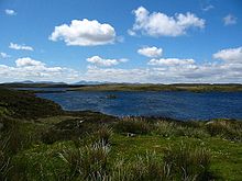
292:. At 27 hectares (67 acres) in extent, it is one of Scotland's larger freshwater islands, but it is probably the largest relative to the size of the body of water in which it sits, Loch Orasaigh being only about 125 hectares (310 acres) in area.
429:
419:
54:
89:
245:
144:
299:
since 1983 and the island's perimeter and the neighbouring islet to the south west have woodland cover including the species of
184:
104:
322:
The Gaelic name of the island means "large island of
Rainish" and is taken from the surrounding area, which itself means "
83:
97:
206:
172:
424:
236:
281:
340:
400:
378:
312:
308:
300:
289:
374:
304:
21:
394:
199:
177:
413:
285:
344:. (pdf) (2008) Comhairle nan Eilean Siar/SNH. Stornoway. Retrieved 23 January 2010.
260:
247:
119:
106:
327:
323:
277:
189:
316:
231:
276:
is an uninhabited island in Loch
Orasaigh, north of the village of
230:
296:
311:, Grey Willow and Sallow Willow. The underlying geology is
341:
Western Isles Native
Woodland Restoration Survey Report
235:
Loch
Orasaigh and Rainish Eilean Mòr with the hills of
27:
220:
212:
205:
195:
183:
171:
166:
158:
150:
140:
135:
96:
82:
43:
35:
20:
74:Rainish Eilean Mòr shown within the Outer Hebrides
8:
61:
17:
430:Uninhabited islands of the Outer Hebrides
420:Freshwater islands of the Outer Hebrides
354:
360:
358:
295:The entirety of the loch has been an
7:
14:
221:
60:
53:
222:
34:
1:
393:Mac an Tàilleir, Iain (2003)
403:. Retrieved 26 August 2012.
446:
383:(Map). 1:25,000. Leisure.
48:
396:Ainmean-àite/Placenames
162:70 m (230 ft)
39:large island of Rainish
240:
28:
234:
154:27 ha (67 acres)
261:58.16139°N 6.44528°W
401:Pàrlamaid na h-Alba
257: /
116: /
315:overlain by peaty
274:Rainish Eilean Mòr
266:58.16139; -6.44528
241:
178:Na h-Eileanan Siar
136:Physical geography
68:Rainish Eilean Mòr
29:Rainish Eilean Mòr
364:SNH (2008) p. 18.
229:
228:
159:Highest elevation
84:OS grid reference
437:
404:
391:
385:
384:
371:
365:
362:
326:headland", from
290:Lewis and Harris
272:
271:
269:
268:
267:
262:
258:
255:
254:
253:
250:
225:
224:
131:
130:
128:
127:
126:
121:
120:58.1637°N 6.44°W
117:
114:
113:
112:
109:
92:
64:
63:
57:
31:
18:
445:
444:
440:
439:
438:
436:
435:
434:
410:
409:
408:
407:
392:
388:
375:Ordnance Survey
373:
372:
368:
363:
356:
351:
336:
313:Lewisian Gneiss
280:in the area of
265:
263:
259:
256:
251:
248:
246:
244:
243:
196:Sovereign state
124:
122:
118:
115:
110:
107:
105:
103:
102:
88:
78:
77:
76:
75:
72:
71:
70:
69:
65:
36:Meaning of name
22:Scottish Gaelic
12:
11:
5:
443:
441:
433:
432:
427:
422:
412:
411:
406:
405:
386:
380:OS Maps Online
366:
353:
352:
350:
347:
346:
345:
335:
332:
227:
226:
218:
217:
214:
210:
209:
203:
202:
200:United Kingdom
197:
193:
192:
187:
181:
180:
175:
169:
168:
167:Administration
164:
163:
160:
156:
155:
152:
148:
147:
142:
138:
137:
133:
132:
125:58.1637; -6.44
100:
94:
93:
86:
80:
79:
73:
67:
66:
59:
58:
52:
51:
50:
49:
46:
45:
41:
40:
37:
33:
32:
25:
13:
10:
9:
6:
4:
3:
2:
442:
431:
428:
426:
425:Isle of Lewis
423:
421:
418:
417:
415:
402:
398:
397:
390:
387:
382:
381:
376:
370:
367:
361:
359:
355:
348:
343:
342:
338:
337:
333:
331:
329:
325:
320:
318:
314:
310:
306:
302:
298:
293:
291:
287:
286:Isle of Lewis
283:
279:
275:
270:
238:
233:
219:
215:
211:
208:
204:
201:
198:
194:
191:
188:
186:
182:
179:
176:
174:
170:
165:
161:
157:
153:
149:
146:
143:
139:
134:
129:
101:
99:
95:
91:
87:
85:
81:
56:
47:
42:
38:
30:
26:
23:
19:
16:
395:
389:
379:
369:
339:
321:
294:
273:
242:
207:Demographics
173:Council area
141:Island group
15:
319:and gleys.
309:Downy Birch
282:South Lochs
264: /
123: /
98:Coordinates
414:Categories
334:References
213:Population
145:Freshwater
108:58°09′49″N
328:Old Norse
252:6°26′43″W
249:58°9′41″N
111:6°26′24″W
399:. (pdf)
324:Roe deer
278:Leurbost
190:Scotland
90:NB386280
44:Location
317:podzols
284:on the
239:beyond.
185:Country
237:Harris
349:Notes
305:Aspen
301:Rowan
297:SSSI
151:Area
24:name
416::
377:.
357:^
330:.
307:,
303:,
288:,
216:0
Text is available under the Creative Commons Attribution-ShareAlike License. Additional terms may apply.