34:
50:
57:
311:
The name
Stanstead is Anglo Saxon for "stony place" and it is easy to appreciate how this came about when viewing the surrounding fields, particularly in the lower part of the village, which are strewn with glacial flint. There is much evidence of earlier Iron Age and Roman settlements in the
615:
331:. The upper part of the village is reached by a 30-metre climb up the hill past Stanstead Hall towards the church and a cluster of houses, a small green and then on to Upper Street and Blooms Hall Lane.
191:
107:
710:
745:
199:
1507:
685:
327:
The village is T-shaped; the lower half of the settlement (Lower Street) follows the B1066 along the bottom of the valley past the old
Stanstead
1572:
235:
33:
1643:
717:
660:
1547:
803:
1542:
217:
49:
1602:
1577:
1562:
1527:
1492:
179:
143:
402:
1597:
1582:
1633:
1537:
1467:
324:. The Parish borders Long Melford in the west, Glemsford to the south, Boxted to the east and Shimpling to the north.
595:
406:
1638:
227:
222:
356:
157:
1607:
1487:
1098:
375:
351:
1103:
952:
796:
585:
1421:
1376:
1250:
280:
89:
1587:
1326:
1295:
1078:
907:
1522:
1512:
1356:
1173:
987:
947:
591:
125:
328:
1612:
1441:
1426:
1255:
1153:
1113:
1028:
997:
917:
831:
502:
420:
296:
1567:
1285:
1280:
1275:
1270:
1183:
1178:
1168:
1138:
1068:
1023:
972:
942:
887:
877:
826:
812:
789:
340:
321:
288:
284:
184:
172:
97:
1592:
1517:
1472:
1341:
1123:
1108:
1088:
1038:
1013:
992:
892:
852:
133:
1371:
1366:
1462:
1381:
1331:
1321:
1311:
1194:
1133:
1073:
1033:
847:
387:
1627:
1557:
1532:
1502:
1497:
1482:
1477:
1436:
1411:
1401:
1386:
1351:
982:
957:
932:
922:
912:
1552:
1431:
1416:
1391:
1361:
1224:
1209:
1204:
1189:
1093:
1083:
1043:
902:
581:
272:
775:
1396:
1063:
962:
283:
for "Stony place". Located off the B1066, it is around 4 miles (6 km) from
1457:
1240:
1158:
1018:
937:
927:
250:
237:
1290:
1219:
1214:
1199:
1143:
1003:
977:
882:
867:
292:
167:
770:
639:
1406:
1346:
1336:
1118:
1053:
1048:
897:
872:
862:
857:
300:
1316:
1265:
1260:
1245:
1148:
1008:
967:
344:
276:
149:
115:
70:
1128:
1058:
785:
371:
393:
Older children attend
Sudbury Upper School and Arts College.
740:
738:
781:
347:. The three tiers of local government are administered by
320:
Stanstead is situated in Glem Valley to the north east of
409:, Stanstead had a population of 316 with 127 households.
291:
district. It is about 2 kilometres (1 mi) from
1450:
1304:
1233:
840:
819:
190:
178:
166:
156:
142:
124:
106:
88:
80:
26:
634:
632:
386:The village is served by Hartest CEVCP School, a
711:"Suffolk County Council - 2001 Census Profiles"
279:, England. The name Stanstead comes from the
797:
8:
594:(c.1594 – 1663), politician and founder of
804:
790:
782:
640:"Introduction to Stanstead Parish Council"
23:
390:currently catering for pupils aged 5–11.
498:
416:
1508:St Peter and St Paul's Church, Lavenham
748:. University of Portsmouth & others
686:"Sudbury Upper School and Arts College"
607:
189:
165:
141:
30:
177:
155:
123:
105:
87:
7:
1573:St Mary's Church, Stoke-by-Nayland
746:"A Vision of Britain Through Time"
14:
1548:Holy Trinity Church, Long Melford
584:(1648 - 1719), cloth merchant in
56:
1543:All Saints Church, Little Wenham
566:A Vision of Britain Through Time
490:A Vision of Britain Through Time
343:district of the shire county of
55:
48:
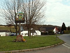
38:Village sign, Stanstead, Suffolk
32:
1603:Wattisham Strict Baptist Chapel
1563:All Saints Church, Newton Green
505:in Stanstead from 1901 to 2001
423:in Stanstead from 1801 to 1891
299:, and 4 miles (6 km) from
403:Office for National Statistics
1:
295:, 12 miles (19 km) from
1578:St Gregory's Church, Sudbury
1528:All Saints' Church, Lawshall
1598:St Mary's Church, Washbrook
370:Shimpling is served by one
21:Human settlement in England
16:Village in Suffolk, England
1660:
1583:St Peter's Church, Sudbury
596:Marlborough, Massachusetts
561:
501:
485:
419:
407:United Kingdom Census 2001
1644:Civil parishes in Suffolk
1538:St James' Chapel, Lindsey
1468:St Mary's Church, Chilton
208:
43:
31:
841:Civil parishes (current)
616:"Parish population 2011"
576:Notable former residents
376:Hedingham & Chambers
361:Stanstead Parish Council
357:Babergh District Council
1234:Civil parishes (former)
1099:Nayland-with-Wissington
1276:Sudbury St Bartholomew
771:Parish Council website
690:Suffolk County Council
665:Suffolk County Council
661:"Hartest CEVCP School"
352:Suffolk County Council
339:Stanstead lies in the
180:Postcode district
1104:Nedging-with-Naughton
953:Copdock and Washbrook
405:, at the time of the
1608:Willy Lott's Cottage
1488:Gainsborough's House
723:on 28 September 2011
374:service operated by
158:Sovereign state
1634:Villages in Suffolk
1588:Tattingstone Wonder
1079:Little Waldingfield
247: /
1523:Lavenham Wool Hall
1513:Lavenham Guildhall
1357:Hanningfield Green
1281:Sudbury St Gregory
1271:Sudbury All Saints
1174:Stratford St. Mary
988:Great Waldingfield
312:surrounding area.
192:UK Parliament
1621:
1620:
1613:Woolverstone Hall
1442:Withermarsh Green
1427:Thorington Street
1305:Other settlements
776:St James's Church
573:
572:
569:
503:Population growth
497:
496:
493:
421:Population growth
413:Population change
401:According to the
287:, and is part of
271:is a village and
266:
265:
108:Shire county
1651:
1639:Babergh District
1568:Smallbridge Hall
1332:Drakestone Green
1286:Sudbury St Peter
1169:Stoke-by-Nayland
806:
799:
792:
783:
778:Suffolk Churches
758:
757:
755:
753:
742:
733:
732:
730:
728:
722:
716:. Archived from
715:
707:
701:
700:
698:
696:
682:
676:
675:
673:
671:
657:
651:
650:
648:
646:
636:
627:
626:
624:
622:
612:
562:
499:
486:
417:
262:
261:
259:
258:
257:
252:
248:
245:
244:
243:
240:
214:
152:
69:Location within
59:
58:
52:
36:
24:
1659:
1658:
1654:
1653:
1652:
1650:
1649:
1648:
1624:
1623:
1622:
1617:
1593:Thorington Hall
1518:Lavenham Priory
1473:Coldham Cottage
1446:
1300:
1251:Hadleigh Hamlet
1229:
1124:Preston St Mary
836:
815:
810:
767:
762:
761:
751:
749:
744:
743:
736:
726:
724:
720:
713:
709:
708:
704:
694:
692:
684:
683:
679:
669:
667:
659:
658:
654:
644:
642:
638:
637:
630:
620:
618:
614:
613:
609:
604:
586:colonial Boston
578:
415:
399:
384:
368:
337:
318:
309:
255:
253:
249:
246:
241:
238:
236:
234:
233:
232:
212:
204:
148:
138:
120:
102:
84:319 (2011)
76:
75:
74:
73:
67:
66:
65:
64:
60:
39:
22:
17:
12:
11:
5:
1657:
1655:
1647:
1646:
1641:
1636:
1626:
1625:
1619:
1618:
1616:
1615:
1610:
1605:
1600:
1595:
1590:
1585:
1580:
1575:
1570:
1565:
1560:
1555:
1550:
1545:
1540:
1535:
1530:
1525:
1520:
1515:
1510:
1505:
1500:
1495:
1490:
1485:
1480:
1475:
1470:
1465:
1463:Bridge Cottage
1460:
1454:
1452:
1448:
1447:
1445:
1444:
1439:
1434:
1429:
1424:
1419:
1414:
1409:
1404:
1399:
1394:
1389:
1384:
1382:Lawshall Green
1379:
1374:
1369:
1364:
1359:
1354:
1349:
1344:
1339:
1334:
1329:
1324:
1319:
1314:
1308:
1306:
1302:
1301:
1299:
1298:
1293:
1288:
1283:
1278:
1273:
1268:
1263:
1258:
1253:
1248:
1243:
1237:
1235:
1231:
1230:
1228:
1227:
1222:
1217:
1212:
1207:
1202:
1197:
1195:Thorpe Morieux
1192:
1187:
1181:
1176:
1171:
1166:
1161:
1156:
1151:
1146:
1141:
1136:
1131:
1126:
1121:
1116:
1111:
1106:
1101:
1096:
1091:
1086:
1081:
1076:
1074:Little Cornard
1071:
1066:
1061:
1056:
1051:
1046:
1041:
1036:
1034:Holton St Mary
1031:
1026:
1021:
1016:
1011:
1006:
1001:
995:
990:
985:
980:
975:
970:
965:
960:
955:
950:
945:
940:
935:
930:
925:
920:
915:
910:
905:
900:
895:
890:
885:
880:
875:
870:
865:
860:
855:
850:
844:
842:
838:
837:
835:
834:
829:
823:
821:
817:
816:
811:
809:
808:
801:
794:
786:
780:
779:
773:
766:
765:External links
763:
760:
759:
734:
702:
677:
652:
628:
606:
605:
603:
600:
599:
598:
589:
577:
574:
571:
570:
559:
558:
555:
552:
549:
546:
543:
540:
537:
533:
532:
529:
526:
523:
520:
517:
514:
511:
507:
506:
495:
494:
483:
482:
479:
476:
473:
470:
467:
464:
461:
458:
454:
453:
450:
447:
444:
441:
438:
435:
432:
429:
425:
424:
414:
411:
398:
395:
388:primary school
383:
380:
367:
364:
363:
362:
359:
354:
336:
333:
317:
314:
308:
305:
264:
263:
251:52.1°N 0.683°E
231:
230:
225:
220:
215:
213:List of places
209:
206:
205:
203:
202:
196:
194:
188:
187:
182:
176:
175:
170:
164:
163:
162:United Kingdom
160:
154:
153:
146:
140:
139:
137:
136:
130:
128:
122:
121:
119:
118:
112:
110:
104:
103:
101:
100:
94:
92:
86:
85:
82:
78:
77:
68:
62:
61:
54:
53:
47:
46:
45:
44:
41:
40:
37:
29:
28:
20:
15:
13:
10:
9:
6:
4:
3:
2:
1656:
1645:
1642:
1640:
1637:
1635:
1632:
1631:
1629:
1614:
1611:
1609:
1606:
1604:
1601:
1599:
1596:
1594:
1591:
1589:
1586:
1584:
1581:
1579:
1576:
1574:
1571:
1569:
1566:
1564:
1561:
1559:
1558:Milden Castle
1556:
1554:
1551:
1549:
1546:
1544:
1541:
1539:
1536:
1534:
1533:Lawshall Hall
1531:
1529:
1526:
1524:
1521:
1519:
1516:
1514:
1511:
1509:
1506:
1504:
1503:Kersey Priory
1501:
1499:
1498:Kentwell Hall
1496:
1494:
1493:Giffords Hall
1491:
1489:
1486:
1484:
1483:Freston Tower
1481:
1479:
1478:Flatford Mill
1476:
1474:
1471:
1469:
1466:
1464:
1461:
1459:
1456:
1455:
1453:
1449:
1443:
1440:
1438:
1437:Windsor Green
1435:
1433:
1430:
1428:
1425:
1423:
1420:
1418:
1415:
1413:
1412:Rooksey Green
1410:
1408:
1405:
1403:
1402:Oldhall Green
1400:
1398:
1395:
1393:
1390:
1388:
1387:Little Wenham
1385:
1383:
1380:
1378:
1375:
1373:
1370:
1368:
1365:
1363:
1360:
1358:
1355:
1353:
1352:Hagmore Green
1350:
1348:
1345:
1343:
1340:
1338:
1335:
1333:
1330:
1328:
1325:
1323:
1320:
1318:
1315:
1313:
1310:
1309:
1307:
1303:
1297:
1294:
1292:
1289:
1287:
1284:
1282:
1279:
1277:
1274:
1272:
1269:
1267:
1264:
1262:
1259:
1257:
1254:
1252:
1249:
1247:
1244:
1242:
1239:
1238:
1236:
1232:
1226:
1223:
1221:
1218:
1216:
1213:
1211:
1208:
1206:
1203:
1201:
1198:
1196:
1193:
1191:
1188:
1185:
1182:
1180:
1177:
1175:
1172:
1170:
1167:
1165:
1162:
1160:
1157:
1155:
1152:
1150:
1147:
1145:
1142:
1140:
1137:
1135:
1132:
1130:
1127:
1125:
1122:
1120:
1117:
1115:
1112:
1110:
1107:
1105:
1102:
1100:
1097:
1095:
1092:
1090:
1087:
1085:
1082:
1080:
1077:
1075:
1072:
1070:
1067:
1065:
1062:
1060:
1057:
1055:
1052:
1050:
1047:
1045:
1042:
1040:
1037:
1035:
1032:
1030:
1027:
1025:
1022:
1020:
1017:
1015:
1012:
1010:
1007:
1005:
1002:
999:
996:
994:
991:
989:
986:
984:
983:Great Cornard
981:
979:
976:
974:
971:
969:
966:
964:
961:
959:
958:East Bergholt
956:
954:
951:
949:
946:
944:
941:
939:
936:
934:
933:Chelmondiston
931:
929:
926:
924:
923:Capel St Mary
921:
919:
916:
914:
913:Bures St Mary
911:
909:
906:
904:
901:
899:
896:
894:
891:
889:
886:
884:
881:
879:
876:
874:
871:
869:
866:
864:
861:
859:
856:
854:
851:
849:
846:
845:
843:
839:
833:
830:
828:
825:
824:
822:
818:
814:
807:
802:
800:
795:
793:
788:
787:
784:
777:
774:
772:
769:
768:
764:
747:
741:
739:
735:
719:
712:
706:
703:
691:
687:
681:
678:
666:
662:
656:
653:
641:
635:
633:
629:
617:
611:
608:
601:
597:
593:
590:
587:
583:
580:
579:
575:
568:
567:
560:
556:
553:
550:
547:
544:
541:
538:
535:
534:
530:
527:
524:
521:
518:
515:
512:
509:
508:
504:
500:
492:
491:
484:
480:
477:
474:
471:
468:
465:
462:
459:
456:
455:
451:
448:
445:
442:
439:
436:
433:
430:
427:
426:
422:
418:
412:
410:
408:
404:
396:
394:
391:
389:
381:
379:
377:
373:
365:
360:
358:
355:
353:
350:
349:
348:
346:
342:
334:
332:
330:
325:
323:
315:
313:
306:
304:
302:
298:
294:
290:
286:
282:
278:
274:
270:
260:
229:
226:
224:
221:
219:
216:
211:
210:
207:
201:
200:South Suffolk
198:
197:
195:
193:
186:
183:
181:
174:
171:
169:
161:
159:
151:
147:
145:
135:
132:
131:
129:
127:
117:
114:
113:
111:
109:
99:
96:
95:
93:
91:
83:
79:
72:
51:
42:
35:
25:
19:
1553:Melford Hall
1432:Upper Layham
1417:Shotley Gate
1392:Lower Layham
1372:Hibb's Green
1367:Hart's Green
1362:Harrow Green
1342:Fenstead End
1225:Woolverstone
1210:Wenham Parva
1205:Wenham Magna
1190:Tattingstone
1163:
1094:Monks Eleigh
1084:Long Melford
1044:Kettlebaston
903:Brent Eleigh
750:. Retrieved
725:. Retrieved
718:the original
705:
693:. Retrieved
689:
680:
668:. Retrieved
664:
655:
643:. Retrieved
621:12 September
619:. Retrieved
610:
582:Robert Calef
565:
563:
489:
487:
400:
392:
385:
369:
338:
326:
319:
310:
273:civil parish
268:
267:
18:
1397:Nedging Tye
1064:Leavenheath
963:Edwardstone
752:28 February
727:28 February
695:28 February
670:28 February
645:28 February
592:Edmund Rice
588:and author.
536:Population
457:Population
281:Old English
256:52.1; 0.683
254: /
1628:Categories
1458:Abbas Hall
1422:The Street
1377:Lambs Lane
1312:Ash Street
1296:Wissington
1241:Ballingdon
1159:Sproughton
1019:Hintlesham
938:Chelsworth
928:Chattisham
908:Brettenham
602:References
397:Demography
335:Governance
329:osier beds
239:52°06′00″N
81:Population
1451:Buildings
1327:Bury Road
1291:Washbrook
1220:Wherstead
1215:Whatfield
1200:Wattisham
1164:Stanstead
1144:Shimpling
1004:Harkstead
978:Glemsford
948:Cockfield
883:Bildeston
868:Assington
382:Education
366:Transport
316:Geography
307:Etymology
293:Glemsford
269:Stanstead
242:0°40′59″E
168:Post town
63:Stanstead
27:Stanstead
1407:Pin Mill
1347:Flatford
1337:Erwarton
1256:Naughton
1154:Somerton
1119:Polstead
1114:Pinewood
1054:Lawshall
1049:Lavenham
1029:Holbrook
998:Hadleigh
918:Burstall
898:Brantham
873:Belstead
863:Arwarton
858:Alpheton
832:Hadleigh
564:Source:
488:Source:
301:Lavenham
297:Hadleigh
90:District
1317:Brundon
1266:Nedging
1261:Nayland
1246:Copdock
1184:Sudbury
1179:Stutton
1149:Shotley
1139:Shelley
1069:Lindsey
1024:Hitcham
1009:Hartest
973:Freston
968:Elmsett
943:Chilton
888:Boxford
878:Bentley
827:Sudbury
813:Babergh
345:Suffolk
341:Babergh
322:Sudbury
289:Babergh
285:Sudbury
277:Suffolk
228:Suffolk
223:England
173:Sudbury
150:England
144:Country
116:Suffolk
98:Babergh
71:Suffolk
1186:(town)
1129:Raydon
1109:Newton
1089:Milden
1059:Layham
1039:Kersey
1014:Higham
1000:(town)
993:Groton
893:Boxted
853:Aldham
126:Region
1322:Bures
1134:Semer
848:Acton
820:Towns
721:(PDF)
714:(PDF)
531:2001
528:1961
525:1951
522:1931
519:1921
516:1911
513:1901
510:Year
452:1891
449:1881
446:1851
443:1841
440:1831
437:1821
434:1811
431:1801
428:Year
754:2011
729:2011
697:2011
672:2011
647:2011
623:2015
557:316
554:276
551:247
548:270
545:291
542:265
539:326
481:368
478:369
475:412
472:387
469:353
466:341
463:284
460:258
185:CO10
134:East
372:bus
275:in
1630::
737:^
688:.
663:.
631:^
378::
303:.
218:UK
805:e
798:t
791:v
756:.
731:.
699:.
674:.
649:.
625:.
Text is available under the Creative Commons Attribution-ShareAlike License. Additional terms may apply.