277:
81:
57:
947:
937:
88:
348:. During the period of the northwestern monsoon (January–March), average temperature is about 28–29 °C, whereas in the southeast (July–September) temperature drops to 26 °C. Regardless of the season, the water temperature in the northern part of the strait is 1–1.5 degrees lower than it is in the southern part. The level of
352:
is more stable: about 33 ‰ in the season of the northwestern monsoons and about 34 ‰ in the southeast period. Sea currents in the strait have a very complex configuration, largely dependent on monsoon seasons: during the northwesterly winds, the northern vector predominates, while in the south-east
364:
At the beginning of the 21st century, there were noticeable negative trends in the development of the ecological situation in the strait and on its shores, related to human economic activity. Numerous cases of water pollution with industrial wastes,
517:
470:
581:
300:
across the strait. The project is obstructed by economic hardships, as well as objections from certain locals in Bali. Currently there is no fixed link to Bali, only a
521:
496:
574:
985:
474:
423:
113:
80:
567:
353:
it is the southern one. The maximum speed – up to 13 km / h – flows reach the northern, most narrow part of the strait.
542:
205:
344:
The temperature of the water in Bali Strait is subject to noticeable seasonal fluctuations, predetermined by the periods of
970:
445:
980:
975:
752:
276:
253:
to the southeast, the Bali Sea to the north, the Indian Ocean to the southwest, and the Bali Strait to the west.
802:
599:
990:
317:
257:
46:
382:
297:
289:
898:
787:
333:
285:
941:
883:
827:
305:
402:
923:
792:
782:
762:
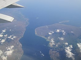
701:
56:
918:
863:
822:
747:
686:
157:
964:
951:
777:
772:
757:
742:
732:
666:
620:
329:
250:
246:
145:
946:
913:
908:
878:
842:
837:
832:
812:
797:
615:
358:
230:
336:, the British merchant ships were able to intimidate the French into withdrawing.
893:
888:
873:
817:
807:
767:
727:
722:
676:
656:
641:
636:
370:
366:
321:
265:
261:
256:
Geologically the two islands of Bali and Java were joined until the end of the
868:
681:
661:
449:
245:
The Bali Strait is one of the bodies of water surrounding the island of Bali:
17:
128:
115:
903:
858:
706:
696:
651:
163:
691:
671:
646:
349:
345:
325:
234:
518:"Pencemaran, Banyuwangi Tunggu Hasil Penelitian Kementerian Lingkungan"
218:
150:
559:
301:
275:
354:
226:
222:
66:
62:
563:
237:. At its narrowest it is 2.4 kilometers (1.5 mi) wide.
208:
National
Geospatial-Intelligence Agency, Bethesda, MD, U.S.
497:"Mega Proyek Jembatan Sunda dan Bali Belum Jadi Prioritas"
264:. They both share part of the tectonic plate called the
851:
715:
629:
608:
543:"Ekosistem Selat Bali Rusak, Mencari Ikan Dilarang"
201:
197:
189:
181:
173:
169:
156:
144:
105:
32:
473:(in Indonesian). Tempo. 2012-07-31. Archived from
471:"Pakde Karwo: Jembatan Selat Bali Batal Dibangun"
424:"Sejarah Kontroversi Proyek Jembatan Selat Sunda"
106:
38:
446:"Gubernur Bali Tetap Tolak Jembatan Jawa-Bali"
575:
332:in the Bali Strait. Disguising themselves as
8:
545:(in Indonesian). BAPPEDA Provinsi Jawa Timur
582:
568:
560:
29:
296:The Indonesian government has considered
27:Stretch of water separating Java and Bali
304:between Ketapang in Java and Gilimanuk,
394:
520:(in Indonesian). Tempo. Archived from
448:(in Indonesian). Gatra. Archived from
7:
373:on the Javanese shore are recorded.
87:
426:(in Indonesian). Tempo. 2012-07-30
25:
328:encountered fleet of six British
945:
935:
86:
79:
55:
369:, as well as chemicals used in
188:
180:
172:
61:Aerial view of the Strait with
316:On 28 January 1797 during the
260:when the sea rose and cut the
1:
185:2.4 kilometers (1.5 mi)
986:Straits of the Indian Ocean
284:in the Bali Strait between
1007:
177:60 kilometers (37 mi)
932:
595:
74:
54:
37:
600:East Indian Archipelago
495:Suhendra (2009-05-31).
444:Tma, Ant (2002-12-02).
193:60 meters (200 ft)
499:(in Indonesian). Detik
293:
39:
279:
229:while connecting the
206:Selat Bali: Indonesia
971:Straits of Indonesia
942:Indonesia portal
318:Bali Strait Incident
125: /
383:Bali Strait Bridge
294:
981:Landforms of Java
976:Landforms of Bali
958:
957:
952:Oceans portal
899:Palabuhanratu Bay
403:"The Bali Strait"
334:ships of the line
282:KMP Sereia Do Mar
249:to the east, the
212:
211:
129:8.300°S 114.417°E
16:(Redirected from
998:
950:
949:
940:
939:
938:
884:Cenderawasih Bay
828:Singapore Strait
584:
577:
570:
561:
554:
553:
551:
550:
539:
533:
532:
530:
529:
514:
508:
507:
505:
504:
492:
486:
485:
483:
482:
467:
461:
460:
458:
457:
441:
435:
434:
432:
431:
420:
414:
413:
411:
409:
399:
357:currents have a
324:squadron of six
306:Jembrana Regency
219:stretch of water
140:
139:
137:
136:
135:
130:
126:
123:
122:
121:
118:
108:
90:
89:
83:
65:on the left and
59:
50:
42:
30:
21:
1006:
1005:
1001:
1000:
999:
997:
996:
995:
961:
960:
959:
954:
944:
936:
934:
928:
924:Yos Sudarso Bay
847:
793:Mentawai Strait
783:Makassar Strait
763:Karimata Strait
711:
702:South China Sea
625:
604:
591:
590:Indonesian seas
588:
558:
557:
548:
546:
541:
540:
536:
527:
525:
516:
515:
511:
502:
500:
494:
493:
489:
480:
478:
469:
468:
464:
455:
453:
443:
442:
438:
429:
427:
422:
421:
417:
407:
405:
401:
400:
396:
391:
379:
342:
314:
274:
243:
160: countries
134:-8.300; 114.417
133:
131:
127:
124:
119:
116:
114:
112:
111:
101:
100:
99:
98:
97:
96:
95:
91:
70:
44:
28:
23:
22:
15:
12:
11:
5:
1004:
1002:
994:
993:
988:
983:
978:
973:
963:
962:
956:
955:
933:
930:
929:
927:
926:
921:
916:
911:
906:
901:
896:
891:
886:
881:
876:
871:
866:
864:Balikpapan Bay
861:
855:
853:
849:
848:
846:
845:
840:
835:
830:
825:
823:Selayar Strait
820:
815:
810:
805:
800:
795:
790:
788:Malacca Strait
785:
780:
775:
770:
765:
760:
755:
753:Dampier Strait
750:
748:Berhala Strait
745:
740:
735:
730:
725:
719:
717:
713:
712:
710:
709:
704:
699:
694:
689:
687:Philippine Sea
684:
679:
674:
669:
664:
659:
654:
649:
644:
639:
633:
631:
627:
626:
624:
623:
618:
612:
610:
606:
605:
603:
602:
596:
593:
592:
589:
587:
586:
579:
572:
564:
556:
555:
534:
509:
487:
462:
436:
415:
393:
392:
390:
387:
386:
385:
378:
375:
341:
338:
313:
310:
273:
272:Transportation
270:
242:
239:
210:
209:
203:
199:
198:
195:
194:
191:
187:
186:
183:
179:
178:
175:
171:
170:
167:
166:
161:
154:
153:
148:
142:
141:
109:
103:
102:
93:
92:
85:
84:
78:
77:
76:
75:
72:
71:
60:
52:
51:
35:
34:
26:
24:
18:Strait of Bali
14:
13:
10:
9:
6:
4:
3:
2:
1003:
992:
989:
987:
984:
982:
979:
977:
974:
972:
969:
968:
966:
953:
948:
943:
931:
925:
922:
920:
917:
915:
912:
910:
907:
905:
902:
900:
897:
895:
892:
890:
887:
885:
882:
880:
877:
875:
872:
870:
867:
865:
862:
860:
857:
856:
854:
850:
844:
841:
839:
836:
834:
831:
829:
826:
824:
821:
819:
816:
814:
811:
809:
806:
804:
801:
799:
796:
794:
791:
789:
786:
784:
781:
779:
778:Madura Strait
776:
774:
773:Lombok Strait
771:
769:
766:
764:
761:
759:
758:Gaspar Strait
756:
754:
751:
749:
746:
744:
743:Bangka Strait
741:
739:
736:
734:
733:Badung Strait
731:
729:
726:
724:
721:
720:
718:
714:
708:
705:
703:
700:
698:
695:
693:
690:
688:
685:
683:
680:
678:
675:
673:
670:
668:
667:Halmahera Sea
665:
663:
660:
658:
655:
653:
650:
648:
645:
643:
640:
638:
635:
634:
632:
628:
622:
621:Pacific Ocean
619:
617:
614:
613:
611:
607:
601:
598:
597:
594:
585:
580:
578:
573:
571:
566:
565:
562:
544:
538:
535:
524:on 2015-08-04
523:
519:
513:
510:
498:
491:
488:
477:on 2016-03-04
476:
472:
466:
463:
452:on 2013-01-24
451:
447:
440:
437:
425:
419:
416:
404:
398:
395:
388:
384:
381:
380:
376:
374:
372:
368:
362:
360:
356:
351:
347:
339:
337:
335:
331:
330:East Indiaman
327:
323:
319:
311:
309:
307:
303:
299:
291:
287:
283:
278:
271:
269:
267:
263:
259:
254:
252:
251:Badung Strait
248:
247:Lombok Strait
240:
238:
236:
232:
228:
224:
220:
216:
207:
204:
200:
196:
192:
190:Average depth
184:
176:
168:
165:
162:
159:
155:
152:
149:
147:
143:
138:
110:
104:
82:
73:
68:
64:
58:
53:
48:
41:
36:
31:
19:
909:Semangka Bay
843:Wetar Strait
838:Sunda Strait
833:Sumba Strait
813:Rupat Strait
798:Ombai Strait
737:
616:Indian Ocean
547:. Retrieved
537:
526:. Retrieved
522:the original
512:
501:. Retrieved
490:
479:. Retrieved
475:the original
465:
454:. Retrieved
450:the original
439:
428:. Retrieved
418:
406:. Retrieved
397:
363:
359:semi-diurnal
343:
315:
295:
281:
258:last ice age
255:
244:
231:Indian Ocean
214:
213:
69:on the right
991:Bali Strait
919:Tomini Gulf
894:Lampung Bay
889:Jakarta Bay
874:Bintuni Bay
818:Sape Strait
808:Riau Strait
803:Pitt Strait
768:Laut Strait
738:Bali Strait
728:Alor Strait
723:Alas Strait
677:Molucca Sea
657:Celebes Sea
642:Arafura Sea
637:Andaman Sea
371:gold mining
367:fertilizers
361:amplitude.
266:Sunda shelf
262:land bridge
221:separating
215:Bali Strait
174:Max. length
132: /
107:Coordinates
94:Bali Strait
33:Bali Strait
965:Categories
869:Berau Gulf
682:Natuna Sea
662:Flores Sea
549:2015-08-04
528:2015-08-04
503:2010-02-03
481:2015-08-05
456:2015-08-05
430:2015-08-05
389:References
286:Banyuwangi
280:The ferry
202:References
182:Min. width
47:Indonesian
40:Selat Bali
914:Tolo Gulf
904:Saleh Bay
879:Boni Gulf
859:Ambon Bay
707:Timor Sea
697:Seram Sea
652:Banda Sea
290:Gilimanuk
241:Geography
164:Indonesia
692:Savu Sea
672:Java Sea
647:Bali Sea
377:See also
350:salinity
346:monsoons
326:frigates
308:, Bali.
298:a bridge
235:Bali Sea
233:and the
120:114°25′E
408:26 June
340:Ecology
312:History
716:Strait
322:French
151:strait
117:8°18′S
43:
609:Ocean
355:Tidal
302:ferry
217:is a
158:Basin
852:Gulf
410:2012
288:and
227:Bali
225:and
223:Java
146:Type
67:Bali
63:Java
630:Sea
967::
320:a
268:.
583:e
576:t
569:v
552:.
531:.
506:.
484:.
459:.
433:.
412:.
292:.
49:)
45:(
20:)
Text is available under the Creative Commons Attribution-ShareAlike License. Additional terms may apply.