22:
99:
112:
397:
427:
119:
385:
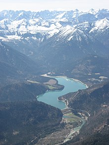
The dam is 44 metres (144 ft) high and 180 metres (590 ft) long. It was built between 1954 and 1959. Since 1959, the water has also been used to operate a hydropower plant of 3.2 MW. The plant was upgraded in 2000 with new turbines to generate 3.8 MW.
393:, the reservoir's maximum capacity was reached. Consequently, excess water was released into the Isar River. Without the dam construction, the flooding in 2005 would have been even more severe than it actually was.
336:
465:
51:
437:
475:
160:
111:
73:
470:
431:
374:
of 4 cubic metres per second is released to prevent the Isar from running dry. Additionally, the reservoir provides
148:
460:
34:
455:
363:
44:
38:
30:
409:
55:
366:. Therefore, the river ran nearly dry during the dry season, and the low water flow affected the town of
390:
370:. A reservoir was established to ensure a minimum water level in the river. During the dry season, a
413:
98:
305:
405:
396:
371:
340:
323:
282:
218:
449:
375:
331:
379:
367:
266:
245:
351:
274:
249:
175:
162:
355:
426:
359:
311:
138:
395:
327:
213:
15:
334:, Germany which impounds the Sylvenstein Reservoir (
304:
299:
291:
281:
261:
256:
240:
232:
224:
212:
207:
199:
191:
154:
144:
134:
91:
43:but its sources remain unclear because it lacks
8:
358:of the upper Isar River such as ones at the
97:
88:
74:Learn how and when to remove this message
466:Hydroelectric power stations in Germany
118:
126:Location of Sylvenstein Dam in Germany
7:
412:connects road traffic to the North (
287:1,100 km (420 sq mi)
14:
295:6.6 km (2.5 sq mi)
425:
117:
110:
20:
330:valley, in the alpine part of
86:Dam in Bad Tölz-Wolfratshausen
1:
438:Information and photographs
378:for the Isar River between
492:
408:was flooded in 1959. The
354:plants were built in the
105:
96:
364:Lake Walchen Power Plant
236:180 m (591 ft)
29:This article includes a
476:Bad Tölz-Wolfratshausen
306:Installed capacity
228:44 m (144 ft)
192:Construction began
149:Bad Tölz-Wolfratshausen
58:more precise citations.
471:Dams completed in 1959
404:A small village named
401:
350:In the 1920s, several
344:
399:
214:Type of dam
176:47.57778°N 11.54111°E
434:at Wikimedia Commons
391:2005 European floods
432:Sylvensteinspeicher
410:Faller-Klamm-Brücke
345:Sylvensteinspeicher
283:Catchment area
262:Total capacity
172: /
402:
181:47.57778; 11.54111
31:list of references
430:Media related to
317:
316:
292:Surface area
248:(35,000,000
208:Dam and spillways
200:Opening date
84:
83:
76:
483:
461:Lakes of Bavaria
442:
429:
414:Bundesstraße 307
339:
272:
187:
186:
184:
183:
182:
177:
173:
170:
169:
168:
165:
121:
120:
114:
101:
89:
79:
72:
68:
65:
59:
54:this article by
45:inline citations
24:
23:
16:
491:
490:
486:
485:
484:
482:
481:
480:
456:Dams in Bavaria
446:
445:
440:
422:
400:Sylvenstein Dam
372:volumetric flow
335:
322:is an earthen
320:Sylvenstein Dam
270:
241:Dam volume
180:
178:
174:
171:
166:
163:
161:
159:
158:
130:
129:
128:
127:
124:
123:
122:
92:Sylvenstein Dam
87:
80:
69:
63:
60:
49:
35:related reading
25:
21:
12:
11:
5:
489:
487:
479:
478:
473:
468:
463:
458:
448:
447:
444:
443:
435:
421:
420:External links
418:
324:embankment dam
315:
314:
308:
302:
301:
297:
296:
293:
289:
288:
285:
279:
278:
263:
259:
258:
254:
253:
242:
238:
237:
234:
230:
229:
226:
222:
221:
219:Embankment dam
216:
210:
209:
205:
204:
201:
197:
196:
193:
189:
188:
156:
152:
151:
146:
142:
141:
136:
132:
131:
125:
116:
115:
109:
108:
107:
106:
103:
102:
94:
93:
85:
82:
81:
64:September 2023
39:external links
28:
26:
19:
13:
10:
9:
6:
4:
3:
2:
488:
477:
474:
472:
469:
467:
464:
462:
459:
457:
454:
453:
451:
439:
436:
433:
428:
424:
423:
419:
417:
415:
411:
407:
398:
394:
392:
387:
383:
381:
377:
376:flood control
373:
369:
365:
361:
357:
353:
348:
346:
342:
338:
333:
332:Upper Bavaria
329:
325:
321:
313:
309:
307:
303:
300:Power Station
298:
294:
290:
286:
284:
280:
276:
268:
264:
260:
255:
251:
247:
243:
239:
235:
231:
227:
223:
220:
217:
215:
211:
206:
202:
198:
194:
190:
185:
157:
153:
150:
147:
143:
140:
137:
133:
113:
104:
100:
95:
90:
78:
75:
67:
57:
53:
47:
46:
40:
36:
32:
27:
18:
17:
403:
388:
384:
382:and Munich.
349:
319:
318:
70:
61:
50:Please help
42:
441:(in German)
389:During the
179: /
155:Coordinates
56:introducing
450:Categories
352:hydropower
275:cu ft
250:cu ft
167:11°32′28″E
164:47°34′40″N
356:tributary
337:‹See Tfd›
265:124
257:Reservoir
380:Bad Tölz
368:Bad Tölz
360:Achensee
273:10
145:Location
326:in the
244:1
139:Germany
135:Country
52:improve
341:German
233:Length
225:Height
37:, or
406:Fall
362:and
328:Isar
269:(4.4
203:1959
195:1954
416:).
347:).
452::
343::
312:MW
310:7
267:hm
246:hm
41:,
33:,
277:)
271:×
252:)
77:)
71:(
66:)
62:(
48:.
Text is available under the Creative Commons Attribution-ShareAlike License. Additional terms may apply.