347:
309:
25:
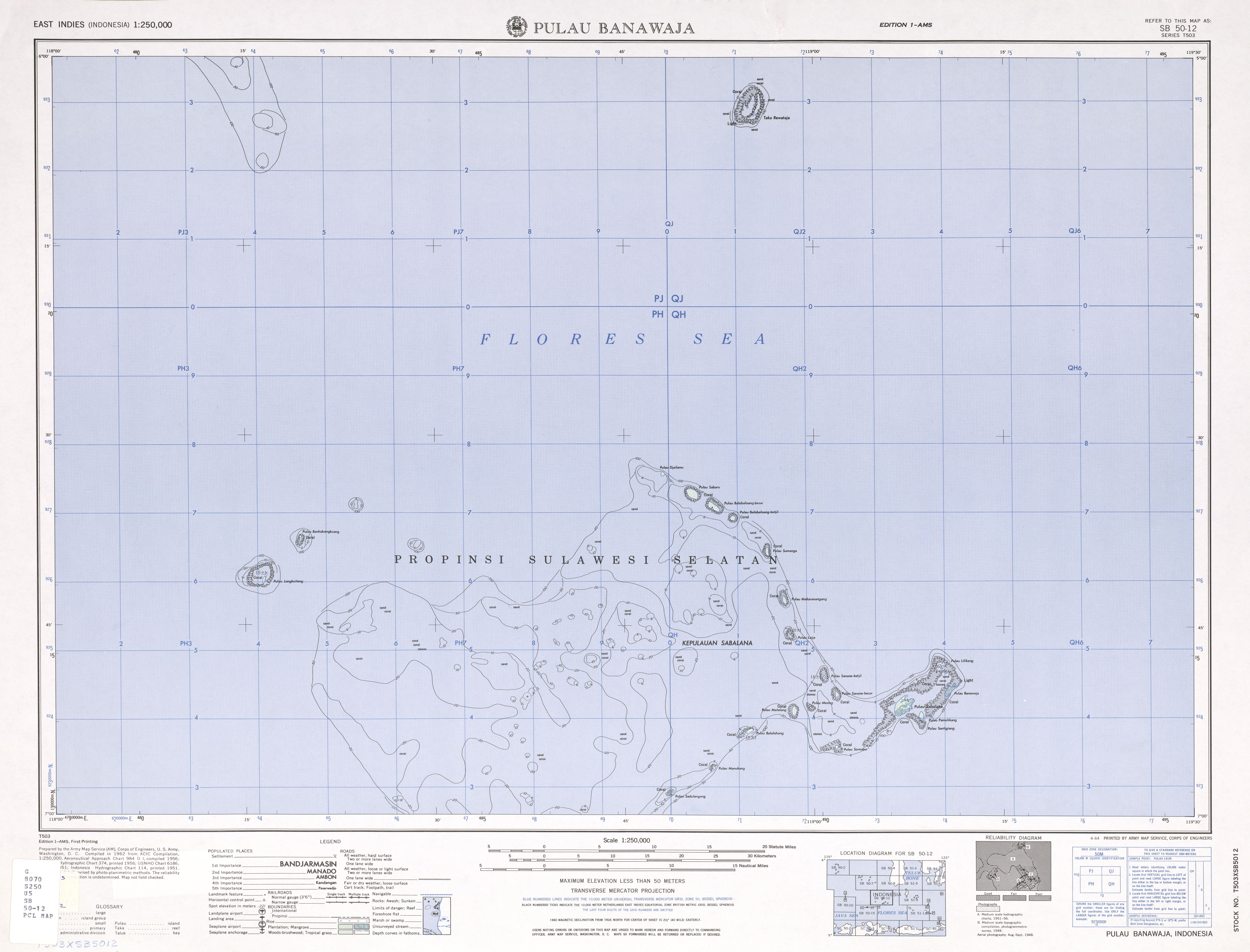
165:, is 2694 km, making Sabalana one of the largest atolls by total area. The land area of the largest individual island, Pulau Sabalana, measures about 7 km, followed by Pulau Banawaja with 3 km and Pulau Sabaru with 1.4 km.
388:
242:
412:
407:
175:
The individual islets are listed, clockwise from the northernmost to the southernmost (the western rim of the atoll is free of islets):
417:
108:
42:
381:
89:
61:
46:
68:
374:
289:
Sailing
Directions for Celebes, Southeast Borneo, Java (except from Java Head to Batavia), and Islands East of Java
75:
327:
322:
287:
57:
35:
332:
138:
150:
346:
82:
358:
354:
314:
158:
154:
401:
24:
304:
134:
257:
244:
308:
157:(Central Islands). Administratively, the atoll belongs to the province of
146:
142:
162:
130:
18:
333:
1:1000,000 topographic map (International Map of the World)
362:
292:. U.S. Government Printing Office. pp. 216–218.
49:. Unsourced material may be challenged and removed.
168:The Sabalana Islands were formerly known as the
382:
8:
389:
375:
286:United States Hydrographic Office (1935).
328:1:250,000 topographic map (southern part)
323:1:250,000 topographic map (northern part)
109:Learn how and when to remove this message
278:
161:. The total area, including the large
137:in Indonesia, lying just north of the
7:
343:
341:
47:adding citations to reliable sources
14:
345:
307:
23:
34:needs additional citations for
1:
153:Island and north-east of the
361:. You can help Knowledge by
209:Pulau Banawaja (easternmost)
413:Landforms of South Sulawesi
434:
408:Archipelagoes of Indonesia
340:
418:Sulawesi geography stubs
188:Pulau Balobaloang-ketjil
185:Pulau Balobaloang-besar
357:location article is a
139:Lesser Sunda Islands
43:improve this article
254: /
200:Pulau Sanane-ketjil
194:Pulau Makaranangang
149:. They are west of
203:Pulau Sanane-besar
127:Kepulauan Sabalana
58:"Sabalana Islands"
370:
369:
258:6.750°S 118.833°E
233:Pulau Sadulangang
170:Postillon Islands
119:
118:
111:
93:
425:
391:
384:
377:
349:
342:
317:
312:
311:
294:
293:
283:
269:
268:
266:
265:
264:
259:
255:
252:
251:
250:
247:
227:Pulau Balalohong
215:Pulau Santigiang
212:Pulau Pamolikang
123:Sabalana Islands
114:
107:
103:
100:
94:
92:
51:
27:
19:
16:Indonesian atoll
433:
432:
428:
427:
426:
424:
423:
422:
398:
397:
396:
395:
338:
313:
306:
303:
298:
297:
285:
284:
280:
275:
263:-6.750; 118.833
262:
260:
256:
253:
248:
245:
243:
241:
240:
115:
104:
98:
95:
52:
50:
40:
28:
17:
12:
11:
5:
431:
429:
421:
420:
415:
410:
400:
399:
394:
393:
386:
379:
371:
368:
367:
355:South Sulawesi
350:
336:
335:
330:
325:
319:
318:
315:Islands portal
302:
301:External links
299:
296:
295:
277:
276:
274:
271:
238:
237:
234:
231:
230:Pulau Manukang
228:
225:
224:Pulau Matalang
222:
219:
216:
213:
210:
207:
206:Pulau Sabalana
204:
201:
198:
195:
192:
189:
186:
183:
180:
179:Pulau Djailamu
159:South Sulawesi
155:Tengah Islands
117:
116:
31:
29:
22:
15:
13:
10:
9:
6:
4:
3:
2:
430:
419:
416:
414:
411:
409:
406:
405:
403:
392:
387:
385:
380:
378:
373:
372:
366:
364:
360:
356:
351:
348:
344:
339:
334:
331:
329:
326:
324:
321:
320:
316:
310:
305:
300:
291:
290:
282:
279:
272:
270:
267:
235:
232:
229:
226:
223:
220:
218:Pulau Soroabu
217:
214:
211:
208:
205:
202:
199:
196:
193:
191:Pulau Sumanga
190:
187:
184:
181:
178:
177:
176:
173:
171:
166:
164:
160:
156:
152:
148:
144:
140:
136:
132:
128:
124:
113:
110:
102:
91:
88:
84:
81:
77:
74:
70:
67:
63:
60: –
59:
55:
54:Find sources:
48:
44:
38:
37:
32:This article
30:
26:
21:
20:
363:expanding it
352:
337:
288:
281:
239:
236:Pulau Sarege
182:Pulau Sabaru
174:
169:
167:
141:, closer to
126:
122:
120:
105:
99:October 2023
96:
86:
79:
72:
65:
53:
41:Please help
36:verification
33:
261: /
221:Pulau Meong
197:Pulau Laija
151:Tanahjampea
402:Categories
273:References
135:Flores Sea
69:newspapers
129:) are an
249:118°50′E
147:Sulawesi
143:Sumbawa
133:in the
83:scholar
246:6°45′S
163:lagoon
85:
78:
71:
64:
56:
353:This
145:than
131:atoll
90:JSTOR
76:books
359:stub
121:The
62:news
45:by
404::
172:.
390:e
383:t
376:v
365:.
125:(
112:)
106:(
101:)
97:(
87:·
80:·
73:·
66:·
39:.
Text is available under the Creative Commons Attribution-ShareAlike License. Additional terms may apply.