116:
123:
633:
184:
33:
342:
398:
233:
Although not the highest, the San Parteo is not easily accessible. Some take a path from
Feliceto, but this route has become notorious because of large landslides. An unmarked mountain path is said to "scale the east flank of the cirque and follows the ridge to the summit, from where you follow the
229:
Until 1935, an Easter Monday procession took place in a chapel, now in ruins, situated at 1600 meters altitude in the San Parteo. The chapel was dedicated to Saint Parthée (San Parteu), a fifth-century saint who was very popular in the
Giunssani.
325:
674:
303:
318:
202:. It is part of a mountain range that marks both the entire northwestern part of the Regional Natural Park of Corsica and the western part of
284:
115:
72:
703:
614:
698:
607:
693:
667:
311:
597:
538:
660:
65:
533:
382:
165:
135:
211:
55:
553:
367:
207:
558:
543:
377:
215:
578:
427:
387:
372:
573:
563:
219:
548:
432:
362:
177:
477:
357:
280:
274:
157:
17:
644:
583:
523:
412:
183:
173:
632:
568:
518:
457:
452:
687:
472:
422:
188:
32:
528:
497:
492:
482:
467:
447:
223:
640:
487:
462:
442:
417:
335:
226:(1937 meters) and San Parteo, and form a large part of the casket of Giunssani.
437:
172:. Situated between the valley of the River Melaja Tartagine and the valley of
87:
74:
203:
195:
199:
234:
spine of another ridge west to rejoin the waymarked trail to
Mausoleo."
176:, the mountain rises to 1,680 metres (5,510 ft). It is part of the
169:
139:
45:
397:
182:
251:
307:
648:
206:. This chain includes some remarkable peaks, mainly
511:
405:
350:
103:
64:
54:
44:
39:
25:
668:
319:
8:
675:
661:
326:
312:
304:
22:
243:
194:San Parteo straddles the communes of
7:
629:
627:
647:. You can help Knowledge (XXG) by
122:
14:
631:
396:
340:
164:) is a mountain peak located in
121:
114:
31:
273:Abram, David (24 March 2003).
1:
279:. Rough Guides. p. 149.
50:1,680 m (5,510 ft)
704:Haute-Corse geography stubs
720:
643:geographical article is a
626:
15:
699:Two-thousanders of France
592:
394:
108:
30:
694:Mountains of Haute-Corse
166:Monticello, Haute-Corse
136:Monticello, Haute-Corse
276:Rough guide to Corsica
191:
186:
88:42.51944°N 8.96417°E
16:For the church, see
214:(2144 meters), the
84: /
433:Cima di e Follicie
192:
178:Monte Cinto massif
40:Highest point
656:
655:
624:
623:
478:Monte San Petrone
383:Monte San Petrone
334:Landforms of the
286:978-1-84353-047-3
150:
149:
93:42.51944; 8.96417
18:San Parteo Church
711:
677:
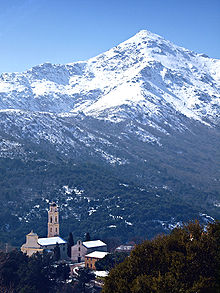
670:
663:
635:
628:
400:
345:
344:
343:
328:
321:
314:
305:
298:
297:
295:
293:
270:
264:
263:
261:
259:
248:
208:Capu Ladroncellu
125:
124:
118:
99:
98:
96:
95:
94:
89:
85:
82:
81:
80:
77:
35:
23:
719:
718:
714:
713:
712:
710:
709:
708:
684:
683:
682:
681:
625:
620:
619:
588:
507:
413:Capo al Berdato
401:
392:
346:
341:
339:
332:
302:
301:
291:
289:
287:
272:
271:
267:
257:
255:
250:
249:
245:
240:
218:(2025 meters),
187:San Pateo from
174:Fiume di Regino
146:
145:
144:
143:
142:
133:
132:
131:
130:
126:
92:
90:
86:
83:
78:
75:
73:
71:
70:
21:
12:
11:
5:
717:
715:
707:
706:
701:
696:
686:
685:
680:
679:
672:
665:
657:
654:
653:
636:
622:
621:
618:
617:
612:
611:
610:
600:
594:
593:
590:
589:
587:
586:
581:
576:
571:
566:
561:
556:
551:
546:
541:
536:
531:
526:
521:
515:
513:
509:
508:
506:
505:
500:
495:
490:
485:
480:
475:
470:
465:
460:
455:
453:Monte Incudine
450:
445:
440:
435:
430:
425:
420:
415:
409:
407:
403:
402:
395:
393:
391:
390:
385:
380:
375:
370:
368:Monte Incudine
365:
360:
354:
352:
348:
347:
333:
331:
330:
323:
316:
308:
300:
299:
285:
265:
242:
241:
239:
236:
216:Capu a u Dente
148:
147:
134:
128:
127:
120:
119:
113:
112:
111:
110:
109:
106:
105:
101:
100:
68:
62:
61:
58:
52:
51:
48:
42:
41:
37:
36:
28:
27:
13:
10:
9:
6:
4:
3:
2:
716:
705:
702:
700:
697:
695:
692:
691:
689:
678:
673:
671:
666:
664:
659:
658:
652:
650:
646:
642:
637:
634:
630:
616:
613:
609:
606:
605:
604:
601:
599:
596:
595:
591:
585:
582:
580:
577:
575:
572:
570:
567:
565:
562:
560:
559:Santo Stefano
557:
555:
552:
550:
547:
545:
544:San Colombano
542:
540:
537:
535:
534:Saint-Antoine
532:
530:
527:
525:
522:
520:
517:
516:
514:
510:
504:
501:
499:
496:
494:
491:
489:
486:
484:
481:
479:
476:
474:
473:Monte Rotondo
471:
469:
466:
464:
461:
459:
456:
454:
451:
449:
446:
444:
441:
439:
436:
434:
431:
429:
428:Cima a i Mori
426:
424:
423:Capu Tafunatu
421:
419:
416:
414:
411:
410:
408:
404:
399:
389:
386:
384:
381:
379:
378:Monte Rotondo
376:
374:
371:
369:
366:
364:
361:
359:
356:
355:
353:
349:
337:
329:
324:
322:
317:
315:
310:
309:
306:
288:
282:
278:
277:
269:
266:
254:. peakery.com
253:
247:
244:
237:
235:
231:
227:
225:
221:
217:
213:
209:
205:
201:
197:
190:
189:Olmi-Cappella
185:
181:
179:
175:
171:
167:
163:
159:
155:
141:
137:
117:
107:
102:
97:
69:
67:
63:
59:
57:
53:
49:
47:
43:
38:
34:
29:
24:
19:
649:expanding it
638:
608:Corse-du-Sud
602:
539:Sainte-Marie
502:
498:Punta Minuta
493:Punta Artica
483:Monte Stello
468:Monte Renoso
448:Monte Grosso
388:Monte Stello
373:Monte Renoso
290:. Retrieved
275:
268:
256:. Retrieved
252:"San-Parteo"
246:
232:
228:
224:Monte Grosso
220:Punta Radich
212:Monte Corona
193:
161:
153:
151:
641:Haute-Corse
615:Waterbodies
554:Santa Lucia
549:San Quilico
488:Paglia Orba
463:Monte Padro
458:Monte d'Oro
443:Monte Cinto
418:Capu Biancu
363:Monte Cinto
338:department
336:Haute-Corse
91: /
66:Coordinates
688:Categories
503:San Parteo
438:Monte Astu
358:Monte Astu
292:27 October
258:27 October
238:References
222:(2012 m),
210:(2145 m),
162:San Parteu
154:San Parteo
129:San Parteo
76:42°31′10″N
56:Prominence
26:San Parteo
603:Landforms
584:Vizzavona
524:Marsolino
204:Giunssani
196:Pioggiola
104:Geography
79:8°57′51″E
46:Elevation
598:Communes
200:Feliceto
158:Corsican
569:Teghime
519:Bigorno
351:Massifs
170:Corsica
140:Corsica
579:Vergio
512:Passes
283:
152:Monte
639:This
574:Verde
564:Sorba
529:Prato
406:Peaks
645:stub
294:2011
281:ISBN
260:2011
198:and
160::
690::
180:.
168:,
138:,
676:e
669:t
662:v
651:.
327:e
320:t
313:v
296:.
262:.
156:(
60:-
20:.
Text is available under the Creative Commons Attribution-ShareAlike License. Additional terms may apply.