362:
inundated forests). All forest types show quite differentiated structure, flora and tree species dominance. Open forest grows on poorly drained, wet or inundated soils. Palm-trees become more frequent on wetter soils. On dryer soils grow the dense lowland rainforests (Not-flooded forests) Open sub-mountain forests grow on the lower hillsides. Dense sub-mountain forests appear on the higher slopes. On the tops grows a " Low forest" with typical and rare sub-Andean species. Open alluvial forests grow on river margins frequently inundated by muddy waters. Dense alluvial forests appear in less frequently inundated areas.
215:
354:
64:
71:
275:
The Serra do
Divisor National Park was created by decree 97.839 on 16 June 1989 to protect and preserve sample of ecosystems, ensure preservation of its natural resources, and allow controlled use by the public, education and scientific research. The consultative council was created on 5 July 2002.
361:
Vegetation: Rapid ecological assessment survey in 1991 characterised 10 forest types within the Park and recorded biodiversity. Most of the area is covered by open rainforest with palm trees or bamboos, dense and open sub-mountain rainforests, and dense and open alluvial rainforests (Periodically
387:
and stones trade. These activities are still incipient. It is planned to remove most of the population towards other, more favourable areas. The remaining population, having deep knowledge of the area, may be involved in the Park's surveillance, maintenance and tourism activities.
370:, and finally: 29 spider families (in the northern sector of the park, only). Of these, 17 mammals, 4 reptiles and 20 birds are considered to be threatened or rare species. Two new bird species were discovered. Local Population 1.200 families.
365:
Fauna: Rapid
Ecological Assessment allowed to count in one month: 43 large mammal species, more than 100 amphibian and 30 reptile species, 485 bird species, 6 families, 33 genres and 55 species of bats, 21 genres and 64 species of
48:
341:. Higher up, are found some tabular well-drained areas (250 m). Higher still, the landscape is mostly made of hills of up to 300 m with poorly marked valleys. The four sierras culminate up to 600 m, with asymmetric
382:
for several generations. Low rubber prices induced these populations to start new and unsustainable activities, like cow ranching, timber cutting, commercial hunting and fishing and animal capturing, as well as
244:(23.12%) in the state of Acre. It has an area of 846,633 hectares (2,092,080 acres). The park is bounded to the west by the border with Peru, which runs along the Serra Divisor mountain range. It adjoins the
304:
The climate is hot and humid tropical, with one to two month dry season. The average temperature in a year is over 24 °C (75 °F). Annual rainfall is 1,750 to 2,000 millimetres (69 to 79 in).
1312:
329:(Serras da Jaquirana, do Moa, do Jurua-Mirim & do Rio Branco), separated by flat plains and valleys of the corresponding affluent of the Juruá basin. Margins of the lower section of the Juruá and
1474:
1099:
560:
633:
280:
launched a campaign to fund the establishment of another national park in the same area on the
Peruvian side of the border. The conservation unit is supported by the
1467:
1304:
1128:
1675:
507:
Ayres, José Márcio; Da
Fonseca, Gustavo A. B.; Rylands, Anthony B.; Queiroz, Helder L.; Pinto, Luiz Paulo; Masterson, Donald; Cavalcanti, Roberto B. (2005),
1660:
202:
border. It also has the highest point in that state, reaching 609 meters above sea level. It has been nominated by the
Brazilian government as a Tentative
106:
969:
63:
1483:
1655:
1460:
1085:
1010:
1035:
1680:
1277:
1056:
1015:
964:
508:
1437:
281:
1136:
1665:
1066:
711:
626:
944:
908:
872:
1285:
1534:
1251:
954:
751:
681:
257:
1670:
1650:
1025:
832:
1092:
1393:
1290:
1256:
979:
898:
867:
862:
857:
245:
984:
949:
852:
847:
777:
736:
619:
1246:
842:
293:
33:
989:
1599:
1202:
1005:
721:
716:
1366:
1030:
837:
746:
731:
1334:
1326:
1158:
1150:
822:
802:
792:
706:
782:
1356:
1040:
1020:
974:
913:
1645:
1388:
1061:
939:
877:
772:
676:
666:
661:
1380:
1194:
903:
827:
701:
378:
Amazonian population live within or just at the margin of the Park's limits, most of whom have been collecting
214:
797:
353:
325:(Brazil), the Park shelters main sources of Jurua 's left margin affluent. It is structured in four main hill
256:
defines the eastern boundary of the northern section. The conservation unit would be included in the proposed
1584:
1579:
1539:
812:
807:
1216:
923:
817:
787:
756:
726:
686:
671:
642:
183:
149:
1504:
1348:
1180:
1172:
918:
696:
338:
264:
241:
225:
561:"Rebranded as the Rainforest Trust, green group launches push to protect 6M acres of Amazon rainforest"
1624:
1415:
882:
691:
233:
1619:
1594:
1549:
1407:
656:
203:
175:
577:
1609:
1544:
1429:
1361:
1238:
959:
527:
313:
Altitudes range from 200 to 600 metres (660 to 1,970 ft). Hilly and mountainous with large
1589:
253:
1574:
1554:
1529:
1524:
1499:
277:
191:
450:
448:
1514:
1509:
1077:
314:
594:
1569:
1559:
322:
249:
237:
1639:
1614:
1604:
1564:
1452:
37:
1109:
229:
195:
90:
367:
543:
121:
108:
1519:
403:
342:
330:
224:
The Serra do
Divisor National Park is divided between the municipalities of
611:
334:
384:
318:
252:
defines the eastern boundary of the southern section of the park. The
1113:
379:
326:
263:
Main access is by boat, on the Moa or Jurua rivers, from the City of
187:
94:
47:
490:
352:
333:
rivers are regularly to permanently inundated, having many lakes,
317:
and some low tabular plateaus. Separating the two basins of Rio
199:
1456:
1081:
615:
276:
The management plan was approved on 24 December 2002. In 2013,
439:
478:
454:
427:
415:
510:
Os
Corredores Ecológicos das Florestas Tropicais do Brasil
70:
1428:
1406:
1379:
1347:
1325:
1303:
1276:
1269:
1237:
1215:
1193:
1171:
1149:
1127:
1120:
1049:
998:
932:
891:
765:
649:
155:
145:
137:
100:
86:
21:
404:Serra Do Divisor National Park – protectedplanet
548:(in Portuguese), ISA: Instituto Socioambiental
182:) is a 8,463 km (3,268 sq mi)
1468:
1093:
627:
8:
466:
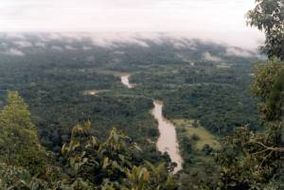
52:Moa River in Serra do Divisor National Park
1475:
1461:
1453:
1425:
1403:
1376:
1344:
1322:
1300:
1273:
1234:
1212:
1190:
1168:
1146:
1124:
1100:
1086:
1078:
634:
620:
612:
18:
516:(in Portuguese), Sociedade Civil Mamirauá
213:
396:
218:Conservation units in the west of Acre.
491:Southwest Amazon moist forests – Myers
282:Amazon Region Protected Areas Program
141:8,463 km (3,268 sq mi)
7:
267:. It has no tourism infrastructure.
85:
1676:Protected areas established in 1989
180:Parque Nacional da Serra do Divisor
27:Parque Nacional da Serra do Divisor
1661:Highest points of Brazilian states
1484:Highest points of Brazilian states
258:Western Amazon Ecological Corridor
14:
220:9. Serra do Divisor National Park
595:"Southwest Amazon moist forests"
578:"Serra Do Divisor National Park"
529:Full list: PAs supported by ARPA
479:Full list: PAs supported by ARPA
248:along its southeast border. The
69:
62:
46:
1656:Protected areas of Acre (state)
455:PARNA da Serra do Divisor – ISA
428:PARNA da Serra do Divisor – ISA
416:PARNA da Serra do Divisor – ISA
154:
357:Serra do Divisor, Acre, Brazil
294:Southwest Amazon moist forests
172:Serra do Divisor National Park
22:Serra do Divisor National Park
1:
1681:1989 establishments in Brazil
246:Alto Juruá Extractive Reserve
430:, Informações gerais (mapa).
345:crests dividing the basins.
186:on the westernmost point of
1666:Environment of Acre (state)
559:Rhett Butler (2013-10-30),
1697:
1490:
970:Nascentes do Rio Parnaíba
545:PARNA da Serra do Divisor
163:
57:
45:
31:
26:
1671:Extreme points of Brazil
1651:National parks of Brazil
643:National parks of Brazil
1313:Seringal Nova Esperança
16:Brazilian National Park
1067:Pantanal Matogrossense
712:Nascentes do Lago Jari
358:
221:
179:
78:Location within Brazil
1286:Igarapé São Francisco
1247:Riozinho da Liberdade
1057:Chapada dos Guimarães
965:Grande Sertão Veredas
955:Chapada dos Veadeiros
752:Tumucumaque Mountains
457:, Historico Juridico.
418:, Informações gerais.
356:
217:
1203:Santa Rosa dos Purus
599:Myers Enterprises II
234:Marechal Thaumaturgo
1590:Rio Grande do Norte
1108:Protected areas in
1036:Lençóis Maranhenses
1026:Jurubatiba Sandbank
1011:Fernando de Noronha
945:Cavernas do Peruaçu
909:Serra das Confusões
833:Saint-Hilaire/Lange
582:protectedplanet.net
292:The park is in the
204:World Heritage Site
118: /
1550:Mato Grosso do Sul
980:Serra da Bodoquena
899:Chapada Diamantina
863:Serra do Gandarela
858:Serra de Itabaiana
359:
222:
1633:
1632:
1595:Rio Grande do Sul
1450:
1449:
1446:
1445:
1424:
1423:
1402:
1401:
1375:
1374:
1343:
1342:
1321:
1320:
1299:
1298:
1265:
1264:
1233:
1232:
1211:
1210:
1189:
1188:
1167:
1166:
1145:
1144:
1137:Japiim-Pentecoste
1075:
1074:
1016:Ilhas dos Currais
985:Serra da Canastra
950:Chapada das Mesas
853:Serra das Lontras
848:Serra da Capivara
778:Aparados da Serra
737:Serra da Mocidade
682:Campos Amazônicos
467:Rhett Butler 2013
440:Ayres et al. 2005
168:
167:
1688:
1646:IUCN Category II
1525:Distrito Federal
1477:
1470:
1463:
1454:
1426:
1404:
1377:
1345:
1323:
1301:
1274:
1235:
1225:Serra do Divisor
1213:
1191:
1169:
1147:
1125:
1102:
1095:
1088:
1079:
873:Serra dos Órgãos
843:Serra da Bocaina
742:Serra do Divisor
636:
629:
622:
613:
607:
606:
605:
590:
589:
588:
573:
572:
571:
555:
554:
553:
539:
538:
537:
523:
522:
521:
515:
494:
488:
482:
476:
470:
464:
458:
452:
443:
437:
431:
425:
419:
413:
407:
401:
278:Rainforest Trust
133:
132:
130:
129:
128:
123:
119:
116:
115:
114:
111:
73:
72:
66:
50:
19:
1696:
1695:
1691:
1690:
1689:
1687:
1686:
1685:
1636:
1635:
1634:
1629:
1486:
1481:
1451:
1442:
1438:Cazumbá-Iracema
1420:
1398:
1371:
1339:
1317:
1295:
1261:
1229:
1207:
1185:
1163:
1141:
1116:
1106:
1076:
1071:
1045:
994:
928:
887:
868:Serra do Itajaí
766:Atlantic Forest
761:
722:Pico da Neblina
645:
640:
610:
603:
601:
593:
586:
584:
576:
569:
567:
558:
551:
549:
542:
535:
533:
526:
519:
517:
513:
506:
502:
497:
489:
485:
477:
473:
465:
461:
453:
446:
438:
434:
426:
422:
414:
410:
402:
398:
394:
376:
351:
315:alluvial plains
311:
302:
290:
273:
265:Cruzeiro do Sul
242:Cruzeiro do Sul
226:Rodrigues Alves
219:
212:
126:
124:
120:
117:
112:
109:
107:
105:
104:
82:
81:
80:
79:
76:
75:
74:
53:
41:
17:
12:
11:
5:
1694:
1692:
1684:
1683:
1678:
1673:
1668:
1663:
1658:
1653:
1648:
1638:
1637:
1631:
1630:
1628:
1627:
1622:
1617:
1612:
1610:Santa Catarina
1607:
1602:
1597:
1592:
1587:
1585:Rio de Janeiro
1582:
1577:
1572:
1567:
1562:
1557:
1552:
1547:
1542:
1537:
1532:
1530:Espírito Santo
1527:
1522:
1517:
1512:
1507:
1502:
1497:
1491:
1488:
1487:
1482:
1480:
1479:
1472:
1465:
1457:
1448:
1447:
1444:
1443:
1441:
1440:
1434:
1432:
1422:
1421:
1419:
1418:
1412:
1410:
1400:
1399:
1397:
1396:
1391:
1385:
1383:
1373:
1372:
1370:
1369:
1364:
1359:
1353:
1351:
1341:
1340:
1338:
1337:
1331:
1329:
1319:
1318:
1316:
1315:
1309:
1307:
1297:
1296:
1294:
1293:
1288:
1282:
1280:
1271:
1267:
1266:
1263:
1262:
1260:
1259:
1254:
1249:
1243:
1241:
1231:
1230:
1228:
1227:
1221:
1219:
1209:
1208:
1206:
1205:
1199:
1197:
1187:
1186:
1184:
1183:
1177:
1175:
1165:
1164:
1162:
1161:
1155:
1153:
1143:
1142:
1140:
1139:
1133:
1131:
1122:
1118:
1117:
1107:
1105:
1104:
1097:
1090:
1082:
1073:
1072:
1070:
1069:
1064:
1059:
1053:
1051:
1047:
1046:
1044:
1043:
1038:
1033:
1031:Lagoa do Peixe
1028:
1023:
1018:
1013:
1008:
1002:
1000:
999:Coastal Marine
996:
995:
993:
992:
987:
982:
977:
972:
967:
962:
957:
952:
947:
942:
936:
934:
930:
929:
927:
926:
921:
916:
911:
906:
901:
895:
893:
889:
888:
886:
885:
880:
875:
870:
865:
860:
855:
850:
845:
840:
835:
830:
825:
820:
815:
810:
805:
800:
795:
790:
785:
780:
775:
769:
767:
763:
762:
760:
759:
754:
749:
747:Serra do Pardo
744:
739:
734:
732:Serra da Cutia
729:
724:
719:
714:
709:
704:
699:
694:
689:
684:
679:
674:
669:
664:
659:
653:
651:
647:
646:
641:
639:
638:
631:
624:
616:
609:
608:
591:
574:
556:
540:
524:
503:
501:
498:
496:
495:
483:
471:
459:
444:
432:
420:
408:
395:
393:
390:
375:
372:
350:
347:
310:
307:
301:
298:
289:
286:
272:
269:
211:
208:
166:
165:
161:
160:
157:
153:
152:
147:
143:
142:
139:
135:
134:
122:8.36°S 73.33°W
102:
98:
97:
88:
84:
83:
77:
68:
67:
61:
60:
59:
58:
55:
54:
51:
43:
42:
32:
29:
28:
24:
23:
15:
13:
10:
9:
6:
4:
3:
2:
1693:
1682:
1679:
1677:
1674:
1672:
1669:
1667:
1664:
1662:
1659:
1657:
1654:
1652:
1649:
1647:
1644:
1643:
1641:
1626:
1623:
1621:
1618:
1616:
1613:
1611:
1608:
1606:
1603:
1601:
1598:
1596:
1593:
1591:
1588:
1586:
1583:
1581:
1578:
1576:
1573:
1571:
1568:
1566:
1563:
1561:
1558:
1556:
1553:
1551:
1548:
1546:
1543:
1541:
1538:
1536:
1533:
1531:
1528:
1526:
1523:
1521:
1518:
1516:
1513:
1511:
1508:
1506:
1503:
1501:
1498:
1496:
1493:
1492:
1489:
1485:
1478:
1473:
1471:
1466:
1464:
1459:
1458:
1455:
1439:
1436:
1435:
1433:
1431:
1427:
1417:
1414:
1413:
1411:
1409:
1405:
1395:
1394:São Francisco
1392:
1390:
1387:
1386:
1384:
1382:
1378:
1368:
1365:
1363:
1360:
1358:
1357:Rio Liberdade
1355:
1354:
1352:
1350:
1346:
1336:
1333:
1332:
1330:
1328:
1324:
1314:
1311:
1310:
1308:
1306:
1302:
1292:
1291:Lago do Amapá
1289:
1287:
1284:
1283:
1281:
1279:
1275:
1272:
1268:
1258:
1255:
1253:
1252:Alto Tarauacá
1250:
1248:
1245:
1244:
1242:
1240:
1236:
1226:
1223:
1222:
1220:
1218:
1214:
1204:
1201:
1200:
1198:
1196:
1192:
1182:
1179:
1178:
1176:
1174:
1170:
1160:
1157:
1156:
1154:
1152:
1148:
1138:
1135:
1134:
1132:
1130:
1126:
1123:
1119:
1115:
1111:
1103:
1098:
1096:
1091:
1089:
1084:
1083:
1080:
1068:
1065:
1063:
1060:
1058:
1055:
1054:
1052:
1048:
1042:
1039:
1037:
1034:
1032:
1029:
1027:
1024:
1022:
1019:
1017:
1014:
1012:
1009:
1007:
1004:
1003:
1001:
997:
991:
990:Serra do Cipó
988:
986:
983:
981:
978:
976:
973:
971:
968:
966:
963:
961:
958:
956:
953:
951:
948:
946:
943:
941:
938:
937:
935:
931:
925:
922:
920:
917:
915:
912:
910:
907:
905:
902:
900:
897:
896:
894:
890:
884:
881:
879:
876:
874:
871:
869:
866:
864:
861:
859:
856:
854:
851:
849:
846:
844:
841:
839:
836:
834:
831:
829:
826:
824:
823:Monte Pascoal
821:
819:
816:
814:
811:
809:
806:
804:
803:Descobrimento
801:
799:
796:
794:
793:Campos Gerais
791:
789:
786:
784:
781:
779:
776:
774:
771:
770:
768:
764:
758:
755:
753:
750:
748:
745:
743:
740:
738:
735:
733:
730:
728:
725:
723:
720:
718:
715:
713:
710:
708:
707:Monte Roraima
705:
703:
700:
698:
695:
693:
690:
688:
685:
683:
680:
678:
675:
673:
670:
668:
665:
663:
660:
658:
655:
654:
652:
648:
644:
637:
632:
630:
625:
623:
618:
617:
614:
600:
596:
592:
583:
579:
575:
566:
562:
557:
547:
546:
541:
531:
530:
525:
512:
511:
505:
504:
499:
492:
487:
484:
480:
475:
472:
468:
463:
460:
456:
451:
449:
445:
442:, p. 32.
441:
436:
433:
429:
424:
421:
417:
412:
409:
405:
400:
397:
391:
389:
386:
381:
373:
371:
369:
363:
355:
348:
346:
344:
340:
336:
332:
328:
324:
320:
316:
308:
306:
299:
297:
295:
287:
285:
283:
279:
270:
268:
266:
261:
259:
255:
251:
247:
243:
240:(31.71%) and
239:
235:
231:
227:
216:
209:
207:
205:
201:
197:
193:
189:
185:
184:national park
181:
177:
173:
162:
158:
151:
150:National park
148:
144:
140:
136:
131:
127:-8.36; -73.33
103:
99:
96:
92:
89:
65:
56:
49:
44:
39:
38:national park
35:
34:IUCN category
30:
25:
20:
1555:Minas Gerais
1494:
1367:Rio Gregório
1224:
1110:Stae of Acre
1021:Jericoacoara
975:Sempre Vivas
914:Sete Cidades
741:
717:Pacaás Novos
602:, retrieved
598:
585:, retrieved
581:
568:, retrieved
564:
550:, retrieved
544:
534:, retrieved
528:
518:, retrieved
509:
486:
474:
462:
435:
423:
411:
399:
377:
368:Hymenopteres
364:
360:
312:
303:
291:
274:
262:
230:Porto Walter
223:
206:since 1998.
171:
169:
1545:Mato Grosso
1062:Ilha Grande
878:Serra Geral
838:São Joaquim
773:Alto Cariri
677:Cabo Orange
667:Anavilhanas
321:(Peru) and
296:ecoregion.
288:Environment
250:Juruá River
238:Mâncio Lima
198:, near the
156:Established
146:Designation
125: /
101:Coordinates
1640:Categories
1575:Pernambuco
1257:Alto Juruá
904:Furna Feia
828:Pau Brasil
783:Araucárias
702:Mapinguari
604:2017-05-22
587:2016-08-08
570:2016-08-08
565:Mongay Bay
552:2016-08-08
536:2016-08-07
520:2016-10-28
392:References
254:Azul River
232:(26.99%),
228:(13.45%),
176:Portuguese
1625:Tocantins
1615:São Paulo
1416:Chandless
1041:Superagüi
808:Guaricana
343:limestone
236:(4.73%),
190:, in the
1600:Rondônia
1540:Maranhão
1510:Amazonas
1335:Rio Acre
1181:Antimary
1159:Rio Acre
1050:Pantanal
1006:Abrolhos
940:Brasília
924:Catimbau
892:Caatinga
818:Itatiaia
788:Boa Nova
727:Rio Novo
687:Jamanxim
672:Araguaia
662:Amazônia
349:Wildlife
339:igarapés
210:Location
200:Peruvian
87:Location
1620:Sergipe
1605:Roraima
1565:Paraíba
1500:Alagoas
933:Cerrado
919:Ubajara
798:Caparaó
697:Juruena
500:Sources
385:fossils
327:massifs
319:Ucayali
309:Terrain
300:Climate
271:History
113:73°20′W
1570:Paraná
1389:Macauã
1114:Brazil
883:Tijuca
813:Iguaçu
650:Amazon
532:, ARPA
380:rubber
374:People
335:igapós
188:Brazil
110:8°22′S
95:Brazil
1580:Piauí
1535:Goiás
1520:Ceará
1515:Bahia
1505:Amapá
1430:RESEX
1381:FLONA
1362:Mogno
1239:RESEX
1217:PARNA
1195:FLONA
757:Viruá
657:Acari
514:(PDF)
323:Juruá
192:state
1560:Pará
1495:Acre
1327:ESEC
1305:ARIE
1270:East
1151:ESEC
1129:ARIE
1121:West
960:Emas
337:and
196:Acre
170:The
159:1989
138:Area
91:Acre
36:II (
1408:PES
1349:FES
1278:APA
1173:FES
692:Jaú
331:Moa
194:of
1642::
1112:,
597:,
580:,
563:,
447:^
284:.
260:.
178::
164:--
93:,
1476:e
1469:t
1462:v
1101:e
1094:t
1087:v
635:e
628:t
621:v
493:.
481:.
469:.
406:.
174:(
40:)
Text is available under the Creative Commons Attribution-ShareAlike License. Additional terms may apply.