526:
72:
42:
35:
65:
1152:
238:
in
Colombia. Serranía del Darién range's average elevation above sea level is 437 metres (1,434 ft). These mountains have sparse settlements, with just two people living in every square kilometer. This lack of human settlements is reflected in the fact that the nearest town with a population of
247:
The Serranía del Darién is notorious for strong earthquakes; on average earthquakes measuring between 6 and 7 occur here every 50 years. The area is also susceptible to floods and landslides, both of which have been classified as medium to high intensity hazards for the region.
327:
367:
1071:
1401:
360:
125:
1396:
608:
34:
945:
64:
657:
1386:
353:
793:
315:
1391:
665:
652:
647:
642:
1311:
1064:
1024:
823:
798:
717:
621:
391:
670:
454:
439:
707:
431:
1329:
1220:
879:
555:
300:
118:
768:
727:
637:
601:
1057:
545:
482:
235:
207:
903:
869:
813:
808:
783:
550:
477:
1195:
998:
778:
712:
492:
968:
803:
722:
697:
692:
462:
257:
575:
565:
467:
444:
1291:
1238:
818:
487:
231:
1334:
920:
788:
758:
594:
540:
978:
935:
851:
399:
525:
1228:
983:
930:
1360:
1350:
1321:
1268:
1253:
1243:
1200:
1116:
925:
889:
763:
753:
680:
227:
1088:
963:
940:
741:
404:
274:
1080:
570:
223:
1276:
1258:
1162:
1017:
955:
884:
861:
856:
839:
629:
508:
412:
1033:
988:
915:
382:
1248:
1180:
1121:
973:
1380:
1296:
1038:
773:
702:
219:
1281:
1170:
874:
1131:
1106:
1306:
1301:
1233:
993:
1151:
1286:
1136:
345:
194:
140:
127:
1101:
1096:
1355:
1190:
1175:
1141:
215:
1185:
1126:
1111:
211:
178:
269:
1365:
1210:
617:
182:
108:
256:
Serranía del Darién is a humid region. Its climate falls under the
1049:
586:
189:
1205:
324:
Amphibian
Species of the World: an Online Reference. Version 6.0
1053:
590:
349:
1150:
230:
of
Colombia. There are two major protected areas here:
295:
293:
291:
1343:
1320:
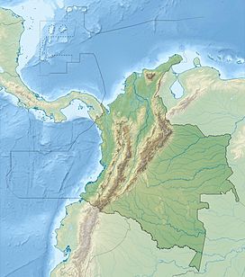
1267:
1219:
1161:
1087:
954:
902:
838:
740:
679:
628:
533:
501:
453:
430:
390:
381:
188:
174:
169:
161:
156:
117:
107:
99:
94:
21:
222:. It is located in the southeastern part of the
1065:
602:
361:
8:
272:to the Serranía del Darién include the toad
226:of Panamá and the northwestern part of the
71:
41:
1072:
1058:
1050:
908:
844:
746:
685:
609:
595:
587:
387:
368:
354:
346:
18:
287:
326:. American Museum of Natural History.
16:Mountain range in Colombia and Panama
7:
1312:Easternmost point of Central America
330:from the original on 8 January 2015
14:
239:50,000 is over 12 hours by road.
206:is a small mountain range on the
524:
70:
63:
40:
33:
671:Reunification of Gran Colombia
1:
1402:Geography of Chocó Department
1397:Landforms of Darién Province
556:Sierra Nevada de Santa Marta
113:1,875 m (6,152 ft)
1387:Mountain ranges of Colombia
946:Water supply and sanitation
440:Serranía de los Churumbelos
376:Mountain ranges of Colombia
1418:
1392:Mountain ranges of Panama
1148:
1011:
911:
847:
749:
688:
522:
478:Serranía de los Yariguíes
314:Frost, Darrel R. (2014).
26:
754:Administrative divisions
666:Separation from Colombia
546:Serranía de Chiribiquete
483:Serranía de las Quinchas
463:Altiplano Cundiboyacense
420:Serranía de San Jerónimo
409:Serranía de los Paraguas
236:Los Katíos National Park
551:Serranía de la Macarena
488:Sierra Nevada del Cocuy
218:in the area called the
165:35 km (22 mi)
1335:Inter-American Highway
1196:El Real de Santa María
1155:
1330:El Llano – Cartí road
1154:
576:Serranía de San Lucas
445:Serranía de las Minas
301:"Serranía Del Darién"
1292:Darién National Park
232:Darién National Park
54:Show map of Colombia
561:Serranía del Darién
541:Serranía de Macuira
493:Serranía del Perijá
204:Serranía del Darién
137: /
78:Serranía del Darién
48:Serranía del Darién
22:Serranía del Darién
1156:
1089:Chepigana District
880:Telecommunications
566:Serranía del Baudó
423:Serranía de Ayapel
405:Farallones de Cali
400:Serranía de Pinche
318:Rhinella acrolopha
275:Rhinella acrolopha
243:Geological hazards
95:Highest point
84:Show map of Panama
1374:
1373:
1277:Bay of San Miguel
1221:Santa Fe District
1163:Pinogana District
1047:
1046:
1007:
1006:
898:
897:
834:
833:
794:Political parties
784:National Assembly
769:Foreign relations
736:
735:
584:
583:
520:
519:
417:Serranía de Abibe
268:Species that are
200:
199:
1409:
1244:Río Congo Arriba
1074:
1067:
1060:
1051:
1027:
1020:
909:
870:Mineral industry
865:
845:
747:
686:
661:
611:
604:
597:
588:
528:
509:Colombian Massif
413:Paramillo Massif
388:
370:
363:
356:
347:
340:
339:
337:
335:
311:
305:
304:
303:. Chinci (2011).
297:
258:tropical monsoon
228:Chocó Department
152:
151:
149:
148:
147:
142:
141:8.167°N 77.300°W
138:
135:
134:
133:
130:
85:
74:
73:
67:
55:
44:
43:
37:
19:
1417:
1416:
1412:
1411:
1410:
1408:
1407:
1406:
1377:
1376:
1375:
1370:
1339:
1316:
1263:
1215:
1157:
1146:
1083:
1081:Darién Province
1078:
1048:
1043:
1030:
1023:
1016:
1003:
999:Public holidays
950:
894:
863:
830:
809:National Police
779:Law enforcement
732:
675:
659:
624:
615:
585:
580:
571:Montes de María
534:Isolated ranges
529:
516:
497:
449:
426:
383:Colombian Andes
377:
374:
344:
343:
333:
331:
313:
312:
308:
299:
298:
289:
284:
266:
264:Flora and fauna
254:
245:
224:Darién Province
145:
143:
139:
136:
131:
128:
126:
124:
123:
103:Cerro Tacarcuna
90:
89:
88:
87:
86:
83:
82:
81:
80:
79:
75:
58:
57:
56:
53:
52:
51:
50:
49:
45:
17:
12:
11:
5:
1415:
1413:
1405:
1404:
1399:
1394:
1389:
1379:
1378:
1372:
1371:
1369:
1368:
1363:
1358:
1353:
1347:
1345:
1341:
1340:
1338:
1337:
1332:
1326:
1324:
1318:
1317:
1315:
1314:
1309:
1304:
1299:
1294:
1289:
1284:
1279:
1273:
1271:
1265:
1264:
1262:
1261:
1256:
1251:
1246:
1241:
1236:
1231:
1225:
1223:
1217:
1216:
1214:
1213:
1208:
1203:
1198:
1193:
1188:
1183:
1178:
1173:
1167:
1165:
1159:
1158:
1149:
1147:
1145:
1144:
1139:
1134:
1129:
1124:
1119:
1114:
1109:
1104:
1099:
1093:
1091:
1085:
1084:
1079:
1077:
1076:
1069:
1062:
1054:
1045:
1044:
1042:
1041:
1036:
1029:
1028:
1021:
1013:
1012:
1009:
1008:
1005:
1004:
1002:
1001:
996:
991:
986:
981:
976:
971:
966:
960:
958:
952:
951:
949:
948:
943:
938:
933:
928:
923:
918:
912:
906:
900:
899:
896:
895:
893:
892:
887:
882:
877:
872:
867:
859:
854:
848:
842:
836:
835:
832:
831:
829:
828:
827:
826:
821:
816:
811:
801:
796:
791:
786:
781:
776:
771:
766:
761:
756:
750:
744:
738:
737:
734:
733:
731:
730:
725:
720:
718:National parks
715:
710:
705:
700:
695:
689:
683:
677:
676:
674:
673:
668:
663:
655:
650:
645:
640:
634:
632:
626:
625:
616:
614:
613:
606:
599:
591:
582:
581:
579:
578:
573:
568:
563:
558:
553:
548:
543:
537:
535:
531:
530:
523:
521:
518:
517:
515:
514:
511:
505:
503:
499:
498:
496:
495:
490:
485:
480:
475:
474:
473:
470:
459:
457:
455:Eastern Ranges
451:
450:
448:
447:
442:
436:
434:
432:Central Ranges
428:
427:
425:
424:
421:
418:
415:
410:
407:
402:
396:
394:
392:Western Ranges
385:
379:
378:
375:
373:
372:
365:
358:
350:
342:
341:
320:(Trueb, 1971)"
306:
286:
285:
283:
280:
265:
262:
253:
250:
244:
241:
234:in Panamá and
198:
197:
192:
186:
185:
176:
172:
171:
167:
166:
163:
159:
158:
154:
153:
146:8.167; -77.300
121:
115:
114:
111:
105:
104:
101:
97:
96:
92:
91:
77:
76:
69:
68:
62:
61:
60:
59:
47:
46:
39:
38:
32:
31:
30:
29:
28:
27:
24:
23:
15:
13:
10:
9:
6:
4:
3:
2:
1414:
1403:
1400:
1398:
1395:
1393:
1390:
1388:
1385:
1384:
1382:
1367:
1364:
1362:
1359:
1357:
1354:
1352:
1349:
1348:
1346:
1342:
1336:
1333:
1331:
1328:
1327:
1325:
1323:
1319:
1313:
1310:
1308:
1305:
1303:
1300:
1298:
1295:
1293:
1290:
1288:
1285:
1283:
1280:
1278:
1275:
1274:
1272:
1270:
1266:
1260:
1257:
1255:
1252:
1250:
1247:
1245:
1242:
1240:
1237:
1235:
1232:
1230:
1227:
1226:
1224:
1222:
1218:
1212:
1209:
1207:
1204:
1202:
1199:
1197:
1194:
1192:
1189:
1187:
1184:
1182:
1179:
1177:
1174:
1172:
1169:
1168:
1166:
1164:
1160:
1153:
1143:
1140:
1138:
1135:
1133:
1130:
1128:
1125:
1123:
1120:
1118:
1115:
1113:
1110:
1108:
1105:
1103:
1100:
1098:
1095:
1094:
1092:
1090:
1086:
1082:
1075:
1070:
1068:
1063:
1061:
1056:
1055:
1052:
1040:
1037:
1035:
1032:
1031:
1026:
1022:
1019:
1015:
1014:
1010:
1000:
997:
995:
992:
990:
987:
985:
982:
980:
977:
975:
972:
970:
967:
965:
962:
961:
959:
957:
953:
947:
944:
942:
939:
937:
934:
932:
929:
927:
924:
922:
919:
917:
914:
913:
910:
907:
905:
901:
891:
888:
886:
883:
881:
878:
876:
873:
871:
868:
866:
860:
858:
855:
853:
850:
849:
846:
843:
841:
837:
825:
822:
820:
817:
815:
812:
810:
807:
806:
805:
804:Public Forces
802:
800:
797:
795:
792:
790:
787:
785:
782:
780:
777:
775:
772:
770:
767:
765:
762:
760:
757:
755:
752:
751:
748:
745:
743:
739:
729:
726:
724:
721:
719:
716:
714:
711:
709:
706:
704:
701:
699:
696:
694:
691:
690:
687:
684:
682:
678:
672:
669:
667:
664:
662:
656:
654:
651:
649:
646:
644:
641:
639:
636:
635:
633:
631:
627:
623:
619:
612:
607:
605:
600:
598:
593:
592:
589:
577:
574:
572:
569:
567:
564:
562:
559:
557:
554:
552:
549:
547:
544:
542:
539:
538:
536:
532:
527:
512:
510:
507:
506:
504:
500:
494:
491:
489:
486:
484:
481:
479:
476:
471:
469:
468:Eastern Hills
466:
465:
464:
461:
460:
458:
456:
452:
446:
443:
441:
438:
437:
435:
433:
429:
422:
419:
416:
414:
411:
408:
406:
403:
401:
398:
397:
395:
393:
389:
386:
384:
380:
371:
366:
364:
359:
357:
352:
351:
348:
329:
325:
321:
319:
310:
307:
302:
296:
294:
292:
288:
281:
279:
277:
276:
271:
263:
261:
259:
251:
249:
242:
240:
237:
233:
229:
225:
221:
217:
213:
209:
205:
196:
193:
191:
187:
184:
180:
177:
173:
168:
164:
160:
155:
150:
122:
120:
116:
112:
110:
106:
102:
98:
93:
66:
36:
25:
20:
1282:Bayano Caves
1249:Río Iglesias
1171:Boca de Cupe
921:Demographics
875:Panama Canal
789:Penal system
759:Constitution
560:
513:Pasto Massif
332:. Retrieved
323:
317:
309:
273:
267:
255:
246:
203:
201:
1344:Settlements
1307:Tuira River
1302:Lago Bayano
1122:Puerto Piña
936:LGBT rights
852:Agriculture
708:Earthquakes
144: /
119:Coordinates
1381:Categories
1297:Darién Gap
1287:Bayano Dam
979:Literature
864:(currency)
799:Presidents
703:Darién Gap
502:Main Andes
472:Suba Hills
282:References
220:Darién Gap
195:Rainforest
157:Dimensions
1322:Transport
1269:Geography
1239:Río Congo
1229:Agua Fría
1132:Setegantí
1107:Garachiné
1102:Chepigana
1097:Camoganti
926:Education
890:Transport
819:SENAFRONT
764:Elections
728:Volcanism
681:Geography
653:1964–1977
648:1904–1964
643:1821–1903
334:8 January
175:Countries
170:Geography
109:Elevation
1361:Santa Fe
1351:La Palma
1259:Zapallal
1254:Santa Fe
1234:Cucunatí
1201:Wargandí
1186:Pinogana
1117:La Palma
1034:Category
941:Religion
742:Politics
622:articles
328:Archived
212:Colombia
210:between
179:Colombia
1137:Taimatí
1018:Outline
964:Cuisine
956:Culture
904:Society
885:Tourism
862:Balboa
857:Banking
840:Economy
713:Islands
660:present
638:to 1821
630:History
270:endemic
252:Climate
132:77°18′W
1366:Yaviza
1356:Metetí
1211:Yaviza
1191:Púcuro
1176:Metetí
1142:Tucutí
1039:Portal
994:People
931:Health
723:Rivers
698:Cities
620:
618:Panama
260:type.
216:Panamá
208:border
183:Panama
162:Length
129:8°10′N
1127:Sambú
1112:Jaqué
1025:Index
989:Music
984:Media
969:Films
916:Crime
814:SENAN
693:Biota
658:1977–
190:Biome
1206:Yape
1181:Paya
974:Flag
336:2015
214:and
202:The
181:and
100:Peak
824:SPI
774:Law
1383::
322:.
290:^
278:.
1073:e
1066:t
1059:v
610:e
603:t
596:v
369:e
362:t
355:v
338:.
316:"
Text is available under the Creative Commons Attribution-ShareAlike License. Additional terms may apply.