327:
363:
347:
58:
375:
212:
42:
320:
Ocean) that had existed between
Scotland and England and the building of mountains of a Himalayan scale to the north west. The Silurian sediments were first buried, then lithified into rock, then folded and uplifted and finally eroded to a horizontal surface before being buried by Devonian sediments washed south from the erosion of the mountains. Further tectonic movements later tilted the whole to its current gentle northward dip.
65:
319:
At the location, near vertical marine sandstones of early
Silurian (Llandovery) age (c.440 Ma) are overlain unconformably by gently dipping terrestrial sandstones of late Devonian age (c.375 Ma). The intervening 65 million years represent a time between the tectonic closing of an ocean (the Iapetus
326:
346:
311:
theory of geological development; that is, that the natural laws and processes which operate in the universe have never changed and apply everywhere. In respect for its great importance to the development of geoscience, this locality was included by the
362:
586:
374:
616:
601:
130:
57:
606:
313:
417:
391:
543:
526:
539:
559:
92:
352:
The eroded sandstone outcrop above conglomerate and vertical ribs of greywacke, still much as when sketched in 1788 by Hutton's companion
566:
550:
281:
to be used as roadstone left a hollow named Old Cambus Quarry which is now occupied by a vegetable distribution warehouse complex.
611:
456:"Classic Rock Tours 1. Hutton's Unconformity at Siccar Point, Scotland: A Guide for Visiting the Shrine on the Abyss of Time"
124:
591:
41:
596:
353:
308:
532:
396:
316:(IUGS) as the first of 100 'geological heritage sites' around the world in a listing published in October 2022.
546:
337:
290:
192:
425:
247:
429:
211:
494:
332:
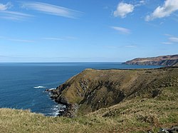
The rugged point, seen from above, shows gently sloping beds of red sandstone above vertical beds of
255:
220:
148:
228:
455:
251:
200:
307:
of the point. He wrote later that the evidence of the rocks provided conclusive proof of the
467:
78:
368:
Field sketch of Hutton's
Unconformity at Siccar Point, Scotland by Sir James Hall (1788).
270:
village of Old Cambus was nearer to Siccar Point than the extant hamlet of Old Cambus.
580:
235:
304:
300:
196:
180:
540:
Research
Casting International hung on scaffolding off the cliffs at Siccar Point
472:
267:
239:
32:
107:
94:
333:
278:
259:
224:
141:
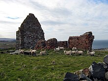
242:, from which the ancient parish church of St Helen's Chapel survives as a
263:
184:
157:
153:
380:
Headlands south of Siccar Point showing tilted strata and unconformities
296:
246:
about one kilometre to the west of the point. The church is built in a
188:
544:
painting a large section of the rocks with thick liquid latex (photo)
274:
210:
587:
Sites of
Special Scientific Interest in Berwickshire and Roxburgh
243:
167:
547:
to fabricate an exhibit for the
Gottesman Hall of Planet Earth
527:
John
Playfair's historic remarks upon seeing Siccar Point
573:(A free online textbook for Historical Geology courses)
299:
as a result of a boat trip in 1788 in which geologist
266:
forming the field boundaries. It is likely that the
163:
147:
137:
123:
23:
466:(1). The Geological Association of Canada: 27–42.
254:believed to have been quarried from the nearby
495:"The First 100 IUGS Geological Heritage Sites"
8:
502:IUGS International Commission on Geoheritage
273:To the south of the point twentieth-century
314:International Union of Geological Sciences
295:Siccar Point is notable in the history of
20:
471:
617:First 100 IUGS Geological Heritage Sites
602:Protected areas in the Scottish Borders
408:
322:
179:is a rocky promontory in the county of
162:
146:
50:
38:
16:Peninsula in Scottish Borders, Scotland
449:
447:
392:List of places in the Scottish Borders
428:School of GeoSciences. Archived from
234:Siccar Point is now in the parish of
136:
122:
7:
199:regarded as conclusive proof of his
64:
551:American Museum of Natural History
238:but was formerly in the parish of
203:theory of geological development.
187:. It is famous in the history of
14:
607:Landforms of the Scottish Borders
373:
361:
345:
325:
63:
56:
40:
416:Cliff Ford (2 September 2003).
336:, forming a classic example of
219:Siccar Point was the site of a
1:
529:, in vol. V, pt. III, 1805,
473:10.12789/geocanj.2018.45.129
284:
46:The point seen from the west
567:VFE: Siccar Point, Scotland
633:
533:Royal Society of Edinburgh
397:List of places in Scotland
288:
227:, in the territory of the
88:
51:
39:
30:
170:Geological Heritage Site
569:— virtual excursion in
426:University of Edinburgh
422:Field Excursion Preview
250:style, in a mixture of
418:"Siccar Point: Safety"
262:rock also used in the
216:
612:Headlands of Scotland
454:Kerr, Andrew (2018).
338:Hutton's Unconformity
291:Hutton's Unconformity
285:Hutton's Unconformity
214:
195:found in 1788, which
193:Hutton's Unconformity
183:on the east coast of
138:Offshore water bodies
531:Transactions of the
305:angular unconformity
108:55.931588°N 2.3012°W
592:Geology of Scotland
432:on 14 February 2012
215:St. Helen's Chapel.
104: /
597:Historical geology
571:Historical Geology
217:
125:Grid position
113:55.931588; -2.3012
460:Geoscience Canada
252:Old Red Sandstone
174:
173:
624:
563:for Siccar Point
562:
514:
513:
511:
509:
499:
491:
485:
484:
482:
480:
475:
451:
442:
441:
439:
437:
413:
377:
365:
349:
329:
133:
119:
118:
116:
115:
114:
109:
105:
102:
101:
100:
97:
79:Scottish Borders
77:Location in the
67:
66:
60:
44:
21:
632:
631:
627:
626:
625:
623:
622:
621:
577:
576:
558:
523:
518:
517:
507:
505:
497:
493:
492:
488:
478:
476:
453:
452:
445:
435:
433:
415:
414:
410:
405:
388:
381:
378:
369:
366:
357:
350:
341:
330:
293:
287:
229:ancient Britons
209:
129:
112:
110:
106:
103:
98:
95:
93:
91:
90:
84:
83:
82:
81:
75:
74:
73:
72:
68:
47:
35:
26:
17:
12:
11:
5:
630:
628:
620:
619:
614:
609:
604:
599:
594:
589:
579:
578:
575:
574:
564:
556:
554:
537:
522:
521:External links
519:
516:
515:
486:
443:
407:
406:
404:
401:
400:
399:
394:
387:
384:
383:
382:
379:
372:
370:
367:
360:
358:
354:Sir James Hall
351:
344:
342:
331:
324:
309:uniformitarian
289:Main article:
286:
283:
256:Greenheugh Bay
208:
205:
201:uniformitarian
172:
171:
165:
161:
160:
151:
145:
144:
139:
135:
134:
127:
121:
120:
86:
85:
76:
70:
69:
62:
61:
55:
54:
53:
52:
49:
48:
45:
37:
36:
31:
28:
27:
24:
15:
13:
10:
9:
6:
4:
3:
2:
629:
618:
615:
613:
610:
608:
605:
603:
600:
598:
595:
593:
590:
588:
585:
584:
582:
572:
568:
565:
561:
557:
555:
552:
548:
545:
541:
538:
535:
534:
528:
525:
524:
520:
503:
496:
490:
487:
474:
469:
465:
461:
457:
450:
448:
444:
431:
427:
423:
419:
412:
409:
402:
398:
395:
393:
390:
389:
385:
376:
371:
364:
359:
355:
348:
343:
339:
335:
328:
323:
321:
317:
315:
310:
306:
303:observed the
302:
298:
292:
282:
280:
276:
271:
269:
265:
264:drystone dyke
261:
257:
253:
249:
245:
241:
237:
236:Cockburnspath
232:
230:
226:
222:
213:
206:
204:
202:
198:
194:
190:
186:
182:
178:
169:
166:
159:
155:
152:
150:
143:
140:
132:
128:
126:
117:
89:Coordinates:
87:
80:
59:
43:
34:
29:
22:
19:
570:
530:
506:. Retrieved
501:
489:
477:. Retrieved
463:
459:
434:. Retrieved
430:the original
421:
411:
318:
301:James Hutton
294:
272:
233:
218:
197:James Hutton
181:Berwickshire
177:Siccar Point
176:
175:
71:Siccar Point
25:Siccar Point
18:
560:Map sources
258:and of the
223:, or small
164:Designation
111: /
581:Categories
508:2 November
436:20 October
403:References
248:Romanesque
240:Old Cambus
96:55°55′54″N
33:Promontory
334:greywacke
279:greywacke
275:quarrying
260:greywacke
225:hill fort
142:North Sea
99:2°18′04″W
479:21 March
386:See also
268:medieval
185:Scotland
158:Devonian
154:Silurian
131:NT812709
297:geology
207:History
189:geology
504:. IUGS
498:(PDF)
510:2022
481:2022
438:2008
277:for
244:ruin
191:for
168:IUGS
468:doi
221:dun
149:Age
583::
549:,
542:,
500:.
464:45
462:.
458:.
446:^
424:.
420:.
231:.
156:,
553:.
536:.
512:.
483:.
470::
440:.
356:.
340:.
Text is available under the Creative Commons Attribution-ShareAlike License. Additional terms may apply.