78:
22:
36:
92:
300:
428:
222:, and any streams were regulated such that they ran in straight beds along the edges of such a box valley. The aim of these measures was the create a wet
138:
is a north German term for a wet depression, hollow or lowland area. It is mainly used to describe typical cultural landscape elements in eastern
357:, which is mainly found in the south Westphalian area and generally also describes wet valley bottoms, mostly stream-bearing V-shaped valleys.
204:
cultural and agricultural history, people developed these natural landforms by cutting into the edges of the V-shaped valleys (so-called
242:
are generally narrow, trough valleys interspersed in the countryside and lying next to cultivated areas of slightly higher ground or
381:
281:. Conservation and cultural landscape management today have the task of ensuring a balanced relationship between renaturalising
408:
226:
in the now broad, accessible stream meadows which could then be extensively cultivated. In addition the cut, grass sods or
196:
are or were, however, crossed by a stream, but at the very least they always consisted of wet ground. During the course of
188:
soils in this region of north
Germany are dissected by a host of brooks and headstreams, which used to flow in marshy
154:"siek" is a very common component of the names of tracts of land, roads, places and even personal names, e.g.
397:
Vom Wert der feuchten Wiesen, Entstehung, Nutzung und Zerstörung der Sieke im
Ravensberger Hügelland
234:
433:
338:
209:
423:
172:
262:
Since, owing to the changed production conditions in modern agriculture, the grasslands in the
86:
404:
377:
351:
Etymologically probably related and conceptually similar is the valley landform known as a
278:
189:
151:
147:
417:
215:
201:
275:
250:
143:
294:
219:
139:
316:
302:
108:
94:
52:
38:
223:
77:
21:
399:. In: Kreisheimatverein Herford (publ.), Kommunalarchiv Herford (publ.):
197:
30:
228:
353:
271:
244:
185:
76:
20:
266:
have become economically largely superfluous, many unused
232:
were able to be used to fertilise the surrounding fields (
254:), which were raised by the grass sod fertilisation.
270:would become marshy again in the long term without
403:. Verlag für Regionalgeschichte. Bielefeld, 2004.
401:Historisches Jahrbuch für den Kreis Herford 2005
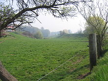
285:on the one hand and regularly mown grassland
89:. Its steep sides are clearly recognisable. (
8:
365:
289:on the other. An example of protected
7:
376:. Aschendorff, Münster 1995, S. 13,
429:Geography of North Rhine-Westphalia
14:
274:and maintenance and turn into
142:, especially in the county of
1:
450:
64:Siek in Bünde-Gewinghausen
214:) and turning them into
238:). In Ravensberg Land,
317:52.228667°N 8.461318°E
130:
109:52.229915°N 8.488955°E
74:
53:52.210447°N 8.556805°E
374:Das Ravensberger Land
146:and in the region of
80:
24:
341:in Ravensberg Land.
322:52.228667; 8.461318
312: /
114:52.229915; 8.488955
104: /
58:52.210447; 8.556805
48: /
131:
120:Siek bei Ostkilver
75:
372:Adolf Schüttler:
441:
395:Florian Herzig:
384:
370:
336:
335:
333:
332:
331:
329:
324:
323:
318:
313:
310:
309:
308:
305:
258:Importance today
190:V-shaped valleys
128:
127:
125:
124:
123:
121:
116:
115:
110:
105:
102:
101:
100:
97:
72:
71:
69:
68:
67:
65:
60:
59:
54:
49:
46:
45:
44:
41:
449:
448:
444:
443:
442:
440:
439:
438:
414:
413:
392:
387:
371:
367:
363:
349:
327:
325:
321:
319:
315:
314:
311:
306:
303:
301:
299:
298:
293:systems is the
260:
182:
152:East Westphalia
148:Ravensberg Land
119:
117:
113:
111:
107:
106:
103:
98:
95:
93:
91:
90:
63:
61:
57:
55:
51:
50:
47:
42:
39:
37:
35:
34:
17:
12:
11:
5:
447:
445:
437:
436:
431:
426:
416:
415:
412:
411:
391:
388:
386:
385:
364:
362:
359:
348:
343:
328:Kilverbachsiek
259:
256:
235:Plaggendüngung
181:
178:
15:
13:
10:
9:
6:
4:
3:
2:
446:
435:
432:
430:
427:
425:
422:
421:
419:
410:
406:
402:
398:
394:
393:
389:
383:
382:3-402-06348-4
379:
375:
369:
366:
360:
358:
356:
355:
347:
344:
342:
340:
339:Wöhrener Siek
334:
296:
292:
288:
284:
280:
277:
273:
269:
265:
257:
255:
253:
252:
247:
246:
241:
237:
236:
231:
230:
225:
221:
217:
213:
212:
207:
206:Wiesenbrechen
203:
199:
195:
191:
187:
179:
177:
175:
174:
169:
165:
161:
157:
153:
149:
145:
141:
137:
136:
126:
88:
84:
79:
70:
32:
28:
23:
19:
400:
396:
373:
368:
352:
350:
345:
290:
286:
282:
267:
263:
261:
251:Plaggenesche
249:
243:
239:
233:
227:
210:
205:
202:early modern
193:
184:The fertile
183:
171:
167:
163:
159:
155:
134:
133:
132:
82:
26:
18:
320: /
276:black alder
220:box valleys
211:Wiskenmaker
112: /
56: /
16:Wet lowland
434:Westphalia
418:Categories
409:389534592X
390:Literature
361:References
337:) and the
326: (
304:52°13′43″N
295:Kilverbach
192:. Not all
140:Westphalia
118: (
96:52°13′48″N
62: (
40:52°12′38″N
424:Landforms
307:8°27′41″E
224:grassland
160:Siekhorst
99:8°29′20″E
87:Ostkilver
43:8°33′24″E
297:valley (
198:medieval
168:Siekmann
156:Heidsiek
229:plaggen
180:Origins
164:Im Siek
407:
380:
354:siepen
346:Siepen
287:sieken
283:sieken
272:mowing
264:sieken
245:kuppen
216:trough
173:Sieker
279:carrs
268:sieke
240:sieke
194:Sieke
186:loess
150:. In
144:Lippe
31:Bünde
405:ISBN
378:ISBN
291:siek
218:and
200:and
170:and
135:Siek
83:siek
27:siek
208:by
85:in
29:in
420::
176:.
166:,
162:,
158:,
81:A
25:A
330:)
248:(
129:)
122:)
73:)
66:)
33:(
Text is available under the Creative Commons Attribution-ShareAlike License. Additional terms may apply.