546:
114:
78:
107:
71:
29:
611:
626:
587:
245:. The surrounding lower elevation lands provide important connectivity habitat between nearby mountain ranges. The area provides critical habitat and movement corridors for
281:, on the west, across the Silurian Valley. Salt Creek flows intermittently through the 19-mile-long (30 km) Silurian Valley connecting Silver Lake to the south with
606:
580:
327:
developed several variations to take advantage of better water sources and to shorten the length and time of travel. The
Kingston Cutoff went southwest from
183:
265:. The Silurian Valley is a largely undisturbed valley that supports wildlife and is an important link for this portion of the northern Mojave Desert.
106:
362:
573:
312:
and Death Valley
National Park. This portion of highway 127 has been described as one of the most scenic in the state. The small community of
402:
382:
70:
353:
553:
527:
466:
169:
358:
324:
498:
621:
616:
313:
176:
317:
545:
301:
238:
386:
305:
304:, traversing through the Silurian Valley in a northwest-southeasterly direction, connects three protected areas:
328:
309:
441:
430:
419:
348:
481:
455:"Latest Quaternary Paleohydrology of Silurian Lake and Salt Spring Basin, Silurian Valley, California"
519:
273:
The range lies in a northwest-southeasterly direction, and is about 9 miles (14 km) long. The
242:
523:
502:
485:
462:
454:
286:
278:
557:
461:, America Special Paper, Boulder, Colorado: Geological Society of America, pp. 129–141,
274:
250:
215:
600:
262:
254:
246:
234:
159:
34:
459:
Paleoenvironments and
Paleohydrology of the Mojave and Southern Great Basin Deserts
290:
282:
28:
91:
198:
185:
258:
420:
U.S. Geological Survey
Geographic Names Information System: Silurian Valley
442:
U.S. Geological Survey
Geographic Names Information System: Silver Lake
431:
U.S. Geological Survey
Geographic Names Information System: Salt Creek
48:
482:"Will renewable energy ruin an 'irreplaceable' Mojave desert oasis?"
457:, in Enzel, Yehouda; Wells, Stephen G.; Lancaster, Nicholas (eds.),
33:
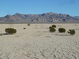
View of
Silurian Hills beyond Silurian Dry Lake, and the occasional
383:"Silurian Valley — a threatened desert treasure: Guest commentary"
406:
220:
499:"BLM rejects application for Silurian Valley energy project"
16:
Range of hills in the Mojave Desert, southern
California
561:
403:"Feds Deny Solar Project Near Mojave National Preserve"
612:
Mountain ranges of San
Bernardino County, California
381:
Prichett, Jack and Brown, Brian (November 14, 2014)
320:lies about 12 miles (19 km) to the southeast.
214:
175:
165:
155:
147:
139:
57:
47:
42:
21:
627:San Bernardino County, California geography stubs
581:
453:Anderson, Kirk C.; Wells, Stephen G. (2003),
8:
588:
574:
18:
363:United States Department of the Interior
340:
397:
395:
285:to the north. Other nearby ranges are
113:
77:
7:
607:Mountain ranges of the Mojave Desert
542:
540:
516:California Road and Recreation Atlas
354:Geographic Names Information System
560:. You can help Knowledge (XXG) by
401:Clarke, Chris (November 25, 2014)
233:are a small range of hills in the
126:Silurian Hills (the United States)
14:
554:San Bernardino County, California
544:
497:Cart, Julie (November 20, 2014)
112:
105:
76:
69:
27:
480:Cart, Julie (November 8, 2014)
359:United States Geological Survey
90:location of Silurian Hills in
1:
129:Show map of the United States
199:35.53330889°N 116.12723861°W
643:
539:
277:lies to the east, and the
239:Death Valley National Park
204:35.53330889; -116.12723861
53:1,056 ft (322 m)
387:San Bernardino County Sun
306:Joshua Tree National Park
62:
26:
329:Mountain Springs, Nevada
310:Mojave National Preserve
556:–related article is a
514:Allan, Stuart (2005).
96:Show map of California
170:San Bernardino County
331:, to Silurian Lake.
622:Silurian California
617:Hills of California
243:southern California
223: Silurian Lake
195: /
43:Highest point
569:
568:
503:Los Angeles Times
486:Los Angeles Times
410:ReWire newsletter
325:Old Spanish Trail
297:Sites of interest
287:Salt Spring Hills
279:Avawatz Mountains
227:
226:
177:Range coordinates
634:
590:
583:
576:
548:
541:
533:
506:
495:
489:
478:
472:
471:
450:
444:
439:
433:
428:
422:
417:
411:
399:
390:
379:
373:
372:
370:
369:
349:"Silurian Hills"
345:
314:Halloran Springs
275:Shadow Mountains
251:desert tortoises
237:, southeast of
210:
209:
207:
206:
205:
200:
196:
193:
192:
191:
188:
130:
116:
115:
109:
97:
80:
79:
73:
31:
19:
642:
641:
637:
636:
635:
633:
632:
631:
597:
596:
595:
594:
537:
530:
513:
510:
509:
496:
492:
479:
475:
469:
452:
451:
447:
440:
436:
429:
425:
418:
414:
400:
393:
380:
376:
367:
365:
347:
346:
342:
337:
299:
271:
203:
201:
197:
194:
189:
186:
184:
182:
181:
135:
134:
133:
132:
131:
128:
127:
124:
123:
122:
121:
117:
100:
99:
98:
95:
94:
88:
87:
86:
85:
81:
38:
17:
12:
11:
5:
640:
638:
630:
629:
624:
619:
614:
609:
599:
598:
593:
592:
585:
578:
570:
567:
566:
549:
535:
534:
528:
522:. p. 97.
520:Benchmark Maps
508:
507:
490:
473:
467:
445:
434:
423:
412:
391:
374:
339:
338:
336:
333:
298:
295:
270:
267:
263:burrowing owls
231:Silurian Hills
225:
224:
218:
212:
211:
190:116°7′38.059″W
187:35°31′59.912″N
179:
173:
172:
167:
163:
162:
157:
153:
152:
149:
145:
144:
141:
137:
136:
125:
120:Silurian Hills
119:
118:
111:
110:
104:
103:
102:
101:
89:
84:Silurian Hills
83:
82:
75:
74:
68:
67:
66:
65:
64:
63:
60:
59:
55:
54:
51:
45:
44:
40:
39:
32:
24:
23:
22:Silurian Hills
15:
13:
10:
9:
6:
4:
3:
2:
639:
628:
625:
623:
620:
618:
615:
613:
610:
608:
605:
604:
602:
591:
586:
584:
579:
577:
572:
571:
565:
563:
559:
555:
550:
547:
543:
538:
531:
529:0-929591-80-1
525:
521:
517:
512:
511:
505:
504:
500:
494:
491:
488:
487:
483:
477:
474:
470:
468:9780813723686
464:
460:
456:
449:
446:
443:
438:
435:
432:
427:
424:
421:
416:
413:
409:
408:
404:
398:
396:
392:
389:
388:
384:
378:
375:
364:
360:
356:
355:
350:
344:
341:
334:
332:
330:
326:
321:
319:
318:Interstate 15
315:
311:
307:
303:
296:
294:
292:
288:
284:
280:
276:
268:
266:
264:
260:
256:
255:golden eagles
252:
248:
247:bighorn sheep
244:
240:
236:
235:Mojave Desert
232:
222:
219:
217:
213:
208:
180:
178:
174:
171:
168:
164:
161:
160:Mojave Desert
158:
154:
150:
146:
143:United States
142:
138:
108:
93:
72:
61:
56:
52:
50:
46:
41:
36:
35:creosote bush
30:
25:
20:
562:expanding it
551:
536:
515:
501:
493:
484:
476:
458:
448:
437:
426:
415:
405:
385:
377:
366:. Retrieved
352:
343:
322:
300:
291:Sperry Hills
283:Death Valley
272:
230:
228:
302:Highway 127
202: /
601:Categories
368:2009-05-04
335:References
253:, nesting
151:California
92:California
269:Geography
259:kit foxes
58:Geography
49:Elevation
216:Topo map
166:District
140:Country
526:
465:
308:, the
156:Region
552:This
316:near
241:, in
148:State
558:stub
524:ISBN
463:ISBN
407:KCET
323:The
289:and
261:and
229:The
221:USGS
603::
518:.
394:^
361:,
357:.
351:.
293:.
257:,
249:,
589:e
582:t
575:v
564:.
532:.
371:.
37:.
Text is available under the Creative Commons Attribution-ShareAlike License. Additional terms may apply.