121:
296:. Accessed September 12, 2019. "Situated at the southwest tip of the Cape May peninsula, the South Cape May Meadows Preserve includes more than 200 acres of critical habitat in the globally renowned birding hot-spot of Cape May, New Jersey.... Established in the 1840s, South Cape May was once a Victorian resort town boasting modest vacation cottages until a storm surge washed much of the town away during the 1950s. Today, remnants of the town lie offshore, scattered on the ocean floor."
653:
314:
445:
280:. Accessed September 12, 2019. "Seven months after the hurricane, on April 30, 1945, the borough of South Cape May officially ceased to exist and the land became part of Lower Township."
346:
718:
530:
614:
694:
339:
428:
723:
164:, which hit in September of that year. After the hurricane, the borough was dissolved as of April 30, 1945, and returned to Lower Township.
713:
433:
332:
728:
277:
186:"Fourteenth Census of The United States: 1920; Population: New Jersey; Number of inhabitants, by counties and minor civil divisions"
289:
553:
509:
474:
423:
548:
161:
304:
687:
558:
590:
216:
192:
139:
568:
247:
494:
389:
355:
154:
120:
733:
601:
542:
484:
479:
374:
96:
81:
66:
51:
537:
563:
680:
586:
499:
469:
384:
369:
600:
St. Raymond
Catholic School merged into Our Lady Star of the Sea in Cape May which merged into what became
595:
582:
395:
293:
124:
489:
185:
135:
504:
464:
459:
229:
407:
269:
234:, Bureau of Geology and Topography; Trenton, New Jersey; 1969. p. 115. Accessed October 16, 2012.
167:
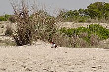
The remaining land not underwater is part of a bird sanctuary (South Cape May
Meadows Preserve).
318:
273:
212:
147:
664:
263:
525:
379:
251:
707:
652:
454:
660:
143:
629:
616:
324:
265:
Remembering South Cape May: The Jersey Shore Town that
Vanished into the Sea
146:, United States, from 1894 to 1945. First settled in 1840, it contained a
243:
213:"Fifteenth Census of the United States : 1930 - Population Volume I"
19:
119:
328:
157:, based on the results of a referendum held six days earlier.
153:
The borough was formed on August 27, 1894, from portions of
668:
302:
231:
The Story of New Jersey's Civil
Boundaries: 1606-1968
518:
444:
416:
362:
184:Wm. C. Hunt, Chief Statistician for Population.
688:
340:
8:
695:
681:
531:Naval Air Station Wildwood Aviation Museum
347:
333:
325:
24:
719:Geography of Cape May County, New Jersey
598:formerly had campuses in Lower Township.
309:
176:
127:on the beach at South Cape May Meadows
44:
160:The borough was badly wrecked by the
150:-type elephant called Light of Asia.
7:
649:
647:
219:, p. 715. Accessed December 5, 2011.
667:. You can help Knowledge (XXG) by
34:
14:
585:are in Lower Township though the
18:Not to be confused with southern
651:
554:Hawk Haven Vineyard & Winery
312:
475:Cold Spring Presbyterian Church
549:Cape May Winery & Vineyard
1:
724:Former boroughs in New Jersey
246:, accessed February 11, 2007
162:1944 Great Atlantic Hurricane
581:Some areas considered to be
569:Turdo Vineyards & Winery
559:Historic Cold Spring Village
217:United States Census Bureau
193:United States Census Bureau
750:
714:Lower Township, New Jersey
646:
495:Naval Air Station Wildwood
434:Lower Cape May Regional HS
429:Lower Cape May Regional SD
356:Lower Township, New Jersey
17:
729:Ghost towns in New Jersey
602:Wildwood Catholic Academy
577:
543:Cape May Point State Park
485:Fishing Creek Schoolhouse
480:Fire Control Tower No. 23
250:February 3, 2007, at the
110:
95:
80:
65:
50:
43:
38:
33:
30:
579:This list is incomplete.
404:(independent until 1945)
392:(independent until 1945)
587:census-designated place
500:Octagonal Poultry House
470:Cold Spring Grange Hall
663:–related article is a
596:Cape Christian Academy
294:The Nature Conservancy
290:South Cape May Meadows
128:
125:American oystercatcher
490:George Hildreth House
123:
26:Historical population
538:Cape May–Lewes Ferry
626: /
589:(CDP) itself is in
505:Jonathan Pyne House
465:Owen Coachman House
460:Cape May Lighthouse
262:Burcher, Joseph G.
27:
510:Rio Grande station
270:Arcadia Publishing
129:
25:
676:
675:
630:38.933°N 74.942°W
609:
608:
424:Lower Township SD
118:
117:
114:
741:
734:New Jersey stubs
697:
690:
683:
655:
648:
641:
640:
638:
637:
636:
631:
627:
624:
623:
622:
619:
526:Cape May Airport
349:
342:
335:
326:
317:
316:
315:
308:
297:
287:
281:
260:
254:
244:Cape May History
241:
235:
228:Snyder, John P.
226:
220:
210:
204:
203:
201:
199:
190:
181:
138:that existed in
112:
46:
41:
36:
28:
749:
748:
744:
743:
742:
740:
739:
738:
704:
703:
702:
701:
644:
635:38.933; -74.942
634:
632:
628:
625:
620:
617:
615:
613:
612:
610:
605:
599:
594:
591:Middle Township
580:
573:
514:
440:
412:
358:
353:
323:
313:
311:
303:
301:
300:
288:
284:
261:
257:
252:Wayback Machine
242:
238:
227:
223:
211:
207:
197:
195:
188:
183:
182:
178:
173:
140:Cape May County
39:
23:
12:
11:
5:
747:
745:
737:
736:
731:
726:
721:
716:
706:
705:
700:
699:
692:
685:
677:
674:
673:
656:
607:
606:
578:
575:
574:
572:
571:
566:
561:
556:
551:
546:
540:
535:
534:
533:
522:
520:
516:
515:
513:
512:
507:
502:
497:
492:
487:
482:
477:
472:
467:
462:
457:
451:
449:
442:
441:
439:
438:
437:
436:
426:
420:
418:
414:
413:
411:
410:
405:
402:South Cape May
399:
393:
390:North Cape May
387:
382:
377:
372:
366:
364:
360:
359:
354:
352:
351:
344:
337:
329:
322:
321:
299:
298:
282:
255:
236:
221:
205:
175:
174:
172:
169:
155:Lower Township
132:South Cape May
116:
115:
108:
107:
104:
102:
99:
93:
92:
89:
87:
84:
78:
77:
74:
72:
69:
63:
62:
59:
57:
54:
48:
47:
42:
37:
32:
13:
10:
9:
6:
4:
3:
2:
746:
735:
732:
730:
727:
725:
722:
720:
717:
715:
712:
711:
709:
698:
693:
691:
686:
684:
679:
678:
672:
670:
666:
662:
657:
654:
650:
645:
642:
639:
603:
597:
592:
588:
584:
576:
570:
567:
565:
562:
560:
557:
555:
552:
550:
547:
544:
541:
539:
536:
532:
529:
528:
527:
524:
523:
521:
517:
511:
508:
506:
503:
501:
498:
496:
493:
491:
488:
486:
483:
481:
478:
476:
473:
471:
468:
466:
463:
461:
458:
456:
453:
452:
450:
447:
443:
435:
432:
431:
430:
427:
425:
422:
421:
419:
415:
409:
406:
403:
400:
397:
394:
391:
388:
386:
383:
381:
378:
376:
375:Diamond Beach
373:
371:
368:
367:
365:
361:
357:
350:
345:
343:
338:
336:
331:
330:
327:
320:
310:
306:
295:
291:
286:
283:
279:
278:9781614232148
275:
271:
267:
266:
259:
256:
253:
249:
245:
240:
237:
233:
232:
225:
222:
218:
214:
209:
206:
194:
187:
180:
177:
170:
168:
165:
163:
158:
156:
151:
149:
145:
141:
137:
133:
126:
122:
109:
105:
103:
100:
98:
94:
90:
88:
85:
83:
79:
75:
73:
70:
68:
64:
60:
58:
55:
53:
49:
29:
21:
16:
669:expanding it
658:
643:
611:
564:Sunset Beach
401:
285:
264:
258:
239:
230:
224:
208:
196:. Retrieved
179:
166:
159:
152:
131:
130:
15:
633: /
455:Battery 223
385:Miami Beach
370:Cold Spring
363:Settlements
708:Categories
661:New Jersey
621:74°56′31″W
618:38°55′59″N
583:Rio Grande
396:Rio Grande
319:New Jersey
171:References
144:New Jersey
268:, p. 94.
198:March 21,
113:1910-1930
448:listings
272:, 2010.
248:Archived
20:Cape May
545:(parts)
417:Schools
136:borough
111:source:
408:Villas
398:(part)
305:Portal
276:
134:was a
106:−40.0%
76:−50.0%
31:Census
659:This
519:Other
189:(ZIP)
91:42.9%
665:stub
446:NRHP
380:Erma
274:ISBN
200:2007
148:Lucy
97:1930
82:1920
67:1910
52:1900
40:Note
35:Pop.
710::
292:,
215:,
191:.
142:,
86:10
56:14
45:%±
696:e
689:t
682:v
671:.
604:.
593:.
348:e
341:t
334:v
307::
202:.
101:6
71:7
61:—
22:.
Text is available under the Creative Commons Attribution-ShareAlike License. Additional terms may apply.