29:
424:
580:
256:
885:
207:
calls this range the Tux Alps. The name Tux
Prealps was declared in the 1984 edition of the AVE as outdated and not longer applicable. The reality is that the mountain range can hardly be described as "prealps" in view of their sheer extent and height. The description only makes any sense when the
530:. Nevertheless, the route, which was first proposed in 1977, has achieved a greater profile than many of the other trails officially established and maintained by states or rambling clubs.
921:
733:
719:
459:. This complex zone belongs, like the quartz-phyllite zone, to the tectonic unit of the Lower Eastern Alps. Amongst the rocks of Tarntal Mesozoic may be found
916:
896:
204:
712:
69:
475:) in the area of the Wattentaler Lizum. On the other hand, there are also elements of the former ocean bed, in the shape of
809:
705:
276:. The Ziller valley (Zillertal) borders the range in the east from the mouth of the Ziller on the Inn upstream as far as
62:
697:
479:
that make up the
Lizumer Reckner. The southern perimeter of the Tux Alps belongs to the tectonically deeper-lying
284:
valley outlines the range from
Mayrhofen to Hintertux. From there the boundary continues up to the saddle of the
180:
315:
794:
356:
158:
380:
869:
729:
549:
497:
327:
323:
597:
492:(calc-schist envelope of the Tauern). The northeasternmost corner of the Tux Alps, from the area of
624:
616:
592:
534:
527:
212:
to the south, which are considerably higher than the Tux Alps and permanently covered in glaciers.
804:
759:
602:
542:
484:
436:
398:
166:
632:
374:
911:
824:
769:
236:
185:
272:
forms the boundary of this range from
Innsbruck downstream to the Inn's confluence with the
350:
269:
230:
169:. The Tux Alps are one of three mountain ranges that form an Alpine backdrop to the city of
859:
789:
460:
344:
174:
142:
874:
839:
784:
779:
774:
754:
749:
502:
273:
242:
209:
124:
654:Überblick zu den Ergebnissen der geologischen Vorerkundung für den Brenner-Basistunnel
165:
within
Central Europe. They are located entirely within the Austrian federal state of
905:
834:
829:
744:
410:
319:
117:
864:
819:
814:
764:
476:
428:
162:
28:
849:
423:
311:
248:
193:
799:
579:
560:
404:
304:
289:
285:
84:
71:
844:
464:
448:
386:
368:
362:
331:
293:
277:
224:
197:
189:
170:
692:
522:
The long-distance hiking trail known as the "Munich to Venice Dream Path" (
255:
480:
452:
444:
281:
884:
392:
297:
220:
The Tux Alps are surrounded by the following other ranges in the Alps:
427:
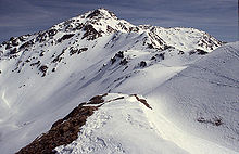
The highest mountain in the Tux Alps, the
Lizumer Reckner, is made of
533:
The 9th day leg of the dream trail runs from Hall in Tirol up to the
511:
507:
493:
52:
16:
Subgroup of
Austrian Central subgroup of Eastern Alps, Central Europe
514:
were once extensively mined in this zone in the area around Schwaz.
314:
and hiking area. Its ski resorts are
Glungezer, Lizum im Wattental,
578:
422:
254:
687:
552:, then over the Pluderling Saddle and the Gschützspitze Saddle.
701:
682:
545:
which is operated by the
Austrian Alpine Club section at Hall.
555:
Other long-distance trails in the Tux Alps are the Eagle Way (
488:. Here in the Tux Alps these are mainly rocks of the Penninic
587:
The following Alpine Club huts are located in the Tux Alps:
451:
rocks to the south there is a localised zone of various
259:
The
Rastkogel (2,762 m), a popular ski touring goal
548:
The 10th and 11th days run from the Lizumer Hut to the
526:) runs through the Tux Alps. This is not an official
205:
Alpine Club classification of the Eastern Alps (AVE)
123:
113:
105:
100:
61:
51:
43:
38:
21:
656:in Geo.Alp, Vol. 5, pp. 165–174, Innsbruck, 2008.
307:saddle links the Tux Alps to the Zillertal Alps.
300:valley from Sankt Jodok downstream to Innsbruck.
296:. To the west the Tux Alps are bounded by the
713:
318:, Penken and Kellerjoch, Patscherkofel. The
196:which is tucked away in a side valley of the
8:
192:. Their name is derived from the village of
435:The largest part of the Tux Alps comprises
720:
706:
698:
439:rocks, that are classified as part of the
18:
922:Mountain ranges of Tyrol (federal state)
645:
567:), Glungezer & Geier Way No. 335 (
500:, belongs to the Upper Eastern Alpine
667:Geologische Übersichtskarte von Tirol
506:, which consists of Paleozoic rocks.
7:
897:Category:Mountain ranges of the Alps
669:1:300,000, Entwurf: Rainer Brandner.
208:range is seen in the context of the
571:), and Central Alpine Way No. 02a.
467:that are the basis of rock faces (
184:, which rises between the glen of
14:
441:Innsbruck quartz-phyllite complex
161:, which in turn form part of the
883:
27:
33:Patscherkofel (2,246m/7,369ft)
1:
541:and the Naviser Jöchl to the
447:slate). Next to this zone of
322:mountain was a venue for the
173:. Their highest peak is the
57:2,886 m (9,469 ft)
917:Mountain ranges of the Alps
569:Glungezer&Geier-Weg 335
518:Long-distance hiking trails
310:The Tux Alps are a popular
938:
810:Rottenmann and Wölz Tauern
537:; the next stage over the
881:
740:
524:Traumpfad München-Venedig
157:) are a sub-group of the
26:
795:Prealps east of the Mur
728:Mountain ranges of the
316:Hochfügen-Hochzillertal
683:Glungez Hut, Lizum Hut
652:Rainer Brandner u.a.:
584:
432:
260:
188:and the valley of the
146:
582:
455:rocks, the so-called
437:low grade metamorphic
426:
258:
159:Austrian Central Alps
870:Villgraten Mountains
730:Central Eastern Alps
563:(red), Olympic Way (
328:1976 Winter Olympics
131:Central Eastern Alps
621:Vinzenz Tolling Hut
539:seven tuxer summits
528:long-distance trail
280:. In the south the
216:Neighbouring ranges
81: /
805:Rieserferner Group
760:Granatspitze Group
585:
498:Fügen im Zillertal
485:Hohe Tauern window
433:
261:
233:(to the northeast)
39:Highest point
892:
891:
825:Schladming Tauern
732:according to the
613:Patscherkofelhaus
583:The Glungezer Hut
268:To the north the
186:Wattentaler Lizum
135:
134:
85:47.167°N 11.633°E
929:
887:
722:
715:
708:
699:
670:
663:
657:
650:
457:Tarntal Mesozoic
288:and through the
270:lower Inn valley
231:Brandenberg Alps
183:
127:
96:
95:
93:
92:
91:
86:
82:
79:
78:
77:
74:
31:
19:
937:
936:
932:
931:
930:
928:
927:
926:
902:
901:
893:
888:
879:
860:Venediger Group
790:Radstadt Tauern
736:
726:
679:
674:
673:
664:
660:
651:
647:
642:
637:
577:
550:Tuxer Joch Haus
520:
421:
416:
345:Lizumer Reckner
340:
330:held in nearby
266:
218:
178:
175:Lizumer Reckner
125:
89:
87:
83:
80:
75:
72:
70:
68:
67:
47:Lizumer Reckner
34:
17:
12:
11:
5:
935:
933:
925:
924:
919:
914:
904:
903:
900:
899:
890:
889:
882:
880:
878:
877:
875:Zillertal Alps
872:
867:
862:
857:
852:
847:
842:
840:Sesvenna Range
837:
832:
827:
822:
817:
812:
807:
802:
797:
792:
787:
782:
780:Lavanttal Alps
777:
775:Kreuzeck Group
772:
770:Kitzbühel Alps
767:
762:
757:
755:Goldberg Group
752:
750:Glockner Group
747:
741:
738:
737:
727:
725:
724:
717:
710:
702:
696:
695:
690:
685:
678:
677:External links
675:
672:
671:
658:
644:
643:
641:
638:
636:
635:
630:
627:
622:
619:
614:
611:
608:
605:
600:
598:Kellerjoch Hut
595:
589:
576:
573:
519:
516:
503:greywacke zone
490:Glockner Nappe
420:
417:
415:
414:
413:, 2,246 m
408:
407:, 2,344 m
402:
401:, 2,395 m
396:
395:, 2,506 m
390:
389:, 2,677 m
384:
383:, 2,725 m
378:
377:, 2,749 m
372:
371:, 2,762 m
366:
365:, 2,796 m
360:
359:, 2,826 m
354:
353:, 2,857 m
348:
347:, 2,886 m
341:
339:
336:
265:
262:
253:
252:
246:
245:(to the south)
243:Zillertal Alps
240:
237:Kitzbühel Alps
234:
228:
227:(to the north)
217:
214:
210:Zillertal Alps
155:Tuxer Voralpen
133:
132:
129:
121:
120:
115:
111:
110:
107:
103:
102:
98:
97:
90:47.167; 11.633
65:
59:
58:
55:
49:
48:
45:
41:
40:
36:
35:
32:
24:
23:
15:
13:
10:
9:
6:
4:
3:
2:
934:
923:
920:
918:
915:
913:
910:
909:
907:
898:
895:
894:
886:
876:
873:
871:
868:
866:
863:
861:
858:
856:
853:
851:
848:
846:
843:
841:
838:
836:
835:Seckau Tauern
833:
831:
830:Schober Group
828:
826:
823:
821:
818:
816:
813:
811:
808:
806:
803:
801:
798:
796:
793:
791:
788:
786:
783:
781:
778:
776:
773:
771:
768:
766:
763:
761:
758:
756:
753:
751:
748:
746:
745:Ankogel Group
743:
742:
739:
735:
731:
723:
718:
716:
711:
709:
704:
703:
700:
694:
691:
689:
686:
684:
681:
680:
676:
668:
665:Tirol Atlas,
662:
659:
655:
649:
646:
639:
634:
631:
628:
626:
625:Voldertal Hut
623:
620:
618:
617:Rastkogel Hut
615:
612:
609:
606:
604:
601:
599:
596:
594:
593:Glungezer Hut
591:
590:
588:
581:
574:
572:
570:
566:
562:
558:
553:
551:
546:
544:
540:
536:
535:Glungezer Hut
531:
529:
525:
517:
515:
513:
509:
505:
504:
499:
495:
491:
487:
486:
482:
478:
474:
470:
466:
462:
458:
454:
450:
446:
442:
438:
430:
425:
418:
412:
411:Patscherkofel
409:
406:
403:
400:
397:
394:
391:
388:
385:
382:
379:
376:
373:
370:
367:
364:
361:
358:
355:
352:
349:
346:
343:
342:
337:
335:
333:
329:
325:
321:
320:Patscherkofel
317:
313:
308:
306:
301:
299:
295:
291:
287:
283:
279:
275:
271:
263:
257:
251:(to the west)
250:
247:
244:
241:
239:(to the east)
238:
235:
232:
229:
226:
223:
222:
221:
215:
213:
211:
206:
201:
199:
195:
191:
187:
182:
176:
172:
168:
164:
160:
156:
152:
148:
144:
140:
130:
128:
122:
119:
116:
112:
108:
104:
99:
94:
66:
64:
60:
56:
54:
50:
46:
42:
37:
30:
25:
20:
865:Verwall Alps
854:
820:Sarntal Alps
815:Samnaun Alps
765:Gurktal Alps
666:
661:
653:
648:
607:Meißner Haus
586:
568:
564:
556:
554:
547:
538:
532:
523:
521:
501:
489:
483:
477:serpentinite
472:
468:
456:
443:(quartzitic
440:
434:
429:serpentinite
309:
302:
267:
219:
202:
163:Eastern Alps
154:
150:
138:
136:
126:Parent range
850:Stubai Alps
785:Ötztal Alps
629:Weertal Hut
603:Lizumer Hut
543:Lizumer Hut
399:Grüblspitze
338:Major peaks
312:ski touring
294:Sankt Jodok
249:Stubai Alps
181:m (AA)
179:2,886
151:Tux Prealps
147:Tuxer Alpen
88: /
63:Coordinates
906:Categories
640:References
633:Weiden Hut
565:Olympiaweg
561:Via Alpina
465:limestones
405:Kellerjoch
375:Malgrübler
305:Tuxer Joch
292:valley to
290:Schmirntal
286:Tuxer Joch
845:Silvretta
693:OeAV Hall
610:Navis Hut
449:Paleozoic
387:Glungezer
369:Rastkogel
363:Rosenjoch
332:Innsbruck
278:Mayrhofen
225:Karwendel
198:Zillertal
190:Navisbach
171:Innsbruck
101:Geography
53:Elevation
912:Tux Alps
855:Tux Alps
688:Adlerweg
557:Adlerweg
481:Penninic
469:Kalkwand
461:dolomite
453:Mesozoic
445:phyllite
357:Kalkwand
282:Tuxertal
264:Boundary
139:Tux Alps
22:Tux Alps
800:Rätikon
559:), the
473:Torwand
419:Geology
393:Gilfert
298:Wipptal
109:Austria
106:Country
76:11°38′E
73:47°10′N
512:copper
508:Silver
494:Schwaz
381:Hirzer
274:Ziller
143:German
351:Geier
167:Tyrol
149:) or
118:Tyrol
114:State
575:Huts
510:and
471:and
463:and
326:and
324:1964
303:The
203:The
137:The
44:Peak
734:AVE
496:to
194:Tux
908::
334:.
200:.
177:,
145::
721:e
714:t
707:v
431:.
153:(
141:(
Text is available under the Creative Commons Attribution-ShareAlike License. Additional terms may apply.