645:
825:
750:
327:
176:
1950:
700:
855:
620:
122:
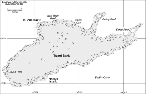
The bank contains a number of features along the rim of the reef, including shoals, reefs, islands, and cays, numerous wrecks, some lighthouses, and an ammunition dumping ground in about 2000m of water to the north of Itu Aba. Several coral heads with depths of 6-12m lie in the lagoon, and depths
169:, 7 miles ESE of Petley Reef, is the easternmost drying reef of the group. The reef is 4.5 miles long with the middle section having a depth of about 1.2m, located at the NE end of the reef. Unoccupied.
115:. The atoll is up to 11.36 nautical miles (21.04 km; 13.07 mi) wide. The total area is 953 square kilometres (368 sq mi), and the greatest depth of the central
107:
The bank rises steeply from surrounding depths ranging from 500 to 700 meters. It is 32.05 nautical miles (59.36 km; 36.88 mi) in length, and extends west from the
1313:
1070:
519:
119:
is 80 meters. The central lagoon generally is 10 to 40 meters deep, although many coral heads have much shallower depths. There are several entrances into the lagoon.
67:
133:(10°11'N 114°22'E) on the S side of the bank is about 12 miles S of Itu Aba. It is less than a metre high and covered with small trees and brush. Occupied by Vietnam.
1802:
1085:
1123:
1910:
1333:
1065:
395:
1980:
512:
139:(10°12'N 114°13'E) consists of two reefs which cover at high tide and lie 7 miles W and 8.5 miles WNW of Namyit Island. Occupied by China.
1822:
1323:
1075:
754:
1343:
570:
112:
86:
1080:
430:
376:
361:
Tizard Bank - Footnote, The China Sea
Directory, Hydrographic Office - Admiralty, published by J D Potter, London 1879, page 66.
1648:
1232:
882:
505:
1807:
1204:
1863:
1833:
1482:
1227:
1189:
1116:
1053:
767:
1194:
1007:
456:
The ammunition dumping ground is about 6.7 nautical miles (12.4 km; 7.7 mi) to the north in water 1900m deep.
1845:
553:
1851:
475:
1109:
93:
Archipelago after the famous Ming-era admiral, although there is no evidence that he ever visited Tizard Bank.
34:
417:
ampton Reefs - the
Southampton Reefs are further east (10°11'N 115°17'E) - and also mis-spells Petley Reef as
123:"3.7m less than charted can be expected. ... Mariners should navigate with extreme caution in this vicinity."
1903:
1817:
1776:
1048:
1915:
1839:
1925:
1581:
1161:
1154:
897:
326:
163:, which dries 0.9m, is about 1 mile in extent and lies on the N side of the bank. Occupied by Vietnam.
151:(Ban Than Reef / Centre Cay) lies on the north edge between Itu Aba and Sand Cay, 3 miles E of Itu Aba
81:(1839 – 17 February 1924), a British oceanographer and surveyor who surveyed the bank from aboard HMS
1975:
1827:
1786:
902:
338:
1857:
1679:
1626:
1533:
1012:
887:
802:
78:
1763:
1596:
1564:
1518:
1497:
1318:
1059:
1022:
992:
877:
727:
677:
390:
1920:
1360:
1295:
1283:
585:
547:
1930:
1884:
1653:
1641:
1636:
1454:
1278:
1209:
1181:
972:
907:
812:
662:
1895:
1730:
1684:
1569:
1492:
1305:
1172:
1132:
997:
947:
590:
528:
1812:
1771:
1753:
1663:
1631:
1601:
1513:
1487:
1439:
1434:
1219:
1090:
1002:
962:
922:
842:
837:
792:
762:
732:
657:
237:
148:
142:
101:
1969:
1954:
1781:
1576:
1523:
1424:
1407:
1370:
1365:
1258:
1237:
1148:
1140:
957:
927:
912:
797:
787:
712:
682:
542:
305:
130:
408:
1949:
1710:
1621:
1554:
1528:
1464:
1380:
1288:
1032:
1027:
1017:
967:
932:
892:
807:
737:
580:
492:
1747:
1705:
1700:
1586:
1559:
1549:
1449:
1419:
1397:
1392:
1253:
937:
872:
867:
777:
772:
749:
717:
672:
667:
632:
600:
575:
342:
334:
265:
160:
136:
108:
1591:
1402:
952:
782:
722:
284:
199:
180:
166:
66:
and one of the significant maritime features of the north-western part of the
49:
36:
1658:
1385:
1199:
917:
687:
17:
74:, China, and Taiwan, and various parts of it are occupied by these states.
443:
1429:
1328:
942:
704:
699:
246:
154:
90:
145:(10°23'N 114°22'E), lies on the NW edge of the bank. Occupied by Taiwan.
859:
854:
444:"Wolfgang Schippke: The Tizard Bank, a large reef in the Spratly Group"
218:
71:
829:
824:
624:
619:
116:
97:
1101:
649:
644:
497:
325:
63:
1105:
501:
96:
From before the 1870s the islands were used by fishermen from
413:
Note that this chart incorrectly labels the bank as the Sout
104:
having a semi-permanent settlement of
Chinese fishermen.
476:"South China Sea: Who Occupies What in the Spratlys?"
396:
United States
National Geospatial-Intelligence Agency
1873:
1795:
1762:
1739:
1723:
1693:
1672:
1614:
1542:
1506:
1475:
1353:
1342:
1304:
1271:
1246:
1218:
1180:
1171:
1139:
1041:
985:
851:
821:
746:
696:
641:
616:
609:
563:
535:
470:
468:
466:
464:
462:
1314:List of maritime features in the Spratly Islands
1071:List of maritime features in the Spratly Islands
157:lies on the north edge, 4.5 miles E of Zhongzhou
1117:
513:
8:
1086:Territorial disputes in the South China Sea
1350:
1339:
1177:
1124:
1110:
1102:
613:
520:
506:
498:
382:South China Sea and the Gulf of Thailand
371:
369:
367:
1334:List of airports in the Spratly Islands
1066:List of airports in the Spratly Islands
354:
1858:Designation of the West Philippine Sea
411:shows the area NW of Dangerous Ground.
7:
1823:Philippines and the Spratly Islands
1324:Royal Malaysian Navy Offshore Bases
1076:Philippines and the Spratly Islands
89:government gave the bank the name
25:
1081:Republic of Morac-Songhrati-Meads
1948:
853:
823:
748:
698:
643:
618:
174:
1808:History of the Spratly Islands
431:Atoll Area, Depth and Rainfall
378:Sailing Directions (Enroute),
126:Features in the area include:
1:
1864:Hai Yang Shi You 981 standoff
1834:Battle of the Paracel Islands
1054:Free Territory of Freedomland
543:Southwest Cay incident (1975)
1981:Banks of the Spratly Islands
1008:Northeast Investigator Shoal
1846:Johnson South Reef skirmish
554:Johnson South Reef Skirmish
1997:
1852:Scarborough Shoal standoff
85:in the 1860s. In 1947 the
1943:
1900:Paracel Islands Airports
333:It is neighboured by the
173:
1911:Spratly Islands Airports
1818:Spratly Islands dispute
1049:Spratly Islands dispute
1840:Southwest Cay incident
330:
62:is a partially sunken
1582:Cornwallis South Reef
898:Cornwallis South Reef
433:, rock.geosociety.org
341:to the west, and the
329:
1828:Battle of Leyte Gulf
1803:Territorial disputes
1787:Tambelan Archipelago
903:Discovery Great Reef
493:Chart of Tizard Bank
339:Discovery Great Reef
1680:Royal Captain Shoal
1627:Central London Reef
1534:Second Thomas Shoal
1329:Vietnamese DK1 rigs
1013:Royal Captain Shoal
986:Unoccupied features
888:Central London Reef
803:Second Thomas Shoal
398:. 2020. p. 11.
79:Thomas Henry Tizard
77:It was named after
70:. It is claimed by
46: /
1764:Tudjuh Archipelago
1597:Investigator Shoal
1565:Johnson South Reef
1519:First Thomas Shoal
1498:Third Thomas Shoal
1319:Great Wall of Sand
1162:South Vereker Bank
1155:North Vereker Bank
1060:Great Wall of Sand
1023:Third Thomas Shoal
993:First Thomas Shoal
878:Barque Canada Reef
728:Investigator Shoal
678:Johnson South Reef
391:Sailing Directions
331:
50:10.250°N 114.500°E
1963:
1962:
1955:Oceans portal
1719:
1718:
1610:
1609:
1361:North Danger Reef
1296:Scarborough Shoal
1284:Macclesfield Bank
1267:
1266:
1099:
1098:
981:
980:
610:Occupied features
586:North Danger Reef
548:East Sea Campaign
320:
302:
290:
280:
261:
233:
214:
195:
87:Republic of China
16:(Redirected from
1988:
1953:
1952:
1885:Coconut Princess
1724:Southeastern SCS
1654:Fiery Cross Reef
1642:West London Reef
1637:East London Reef
1455:West York Island
1351:
1340:
1279:Zhongsha Islands
1272:Northeastern SCS
1182:Amphitrite Group
1178:
1126:
1119:
1112:
1103:
1042:Related articles
973:West London Reef
908:East London Reef
858:
857:
828:
827:
813:West York Island
753:
752:
703:
702:
663:Fiery Cross Reef
648:
647:
623:
622:
614:
571:Dangerous Ground
522:
515:
508:
499:
480:
479:
472:
457:
454:
448:
447:
440:
434:
428:
422:
406:
400:
399:
387:
373:
362:
359:
321:
314:
310:
303:
296:
291:
286:
281:
274:
270:
262:
255:
251:
242:
234:
227:
223:
215:
208:
204:
196:
192:Gaven Reef South
189:
185:
183:Xiao Nanxun Jiao
178:
177:
113:Dangerous Ground
61:
60:
58:
57:
56:
51:
47:
44:
43:
42:
39:
21:
1996:
1995:
1991:
1990:
1989:
1987:
1986:
1985:
1966:
1965:
1964:
1959:
1947:
1939:
1869:
1791:
1777:Anambas Islands
1758:
1735:
1731:Palawan Passage
1715:
1689:
1685:Half Moon Shoal
1668:
1606:
1570:Sin Cowe Island
1538:
1502:
1493:Reed Tablemount
1471:
1345:
1338:
1306:Spratly Islands
1300:
1263:
1242:
1214:
1173:Paracel Islands
1167:
1135:
1133:South China Sea
1130:
1100:
1095:
1037:
998:Half Moon Shoal
977:
948:Sin Cowe Island
852:
847:
822:
817:
747:
742:
697:
692:
642:
637:
617:
605:
591:Reed Tablemount
559:
531:
529:Spratly Islands
526:
489:
484:
483:
474:
473:
460:
455:
451:
442:
441:
437:
429:
425:
412:
409:NGA Chart 93044
407:
403:
385:
375:
374:
365:
360:
356:
351:
324:
323:
322:
313:
312:
306:
295:
294:
293:
285:
282:
273:
272:
266:
263:
254:
253:
247:
244:
238:
235:
226:
225:
219:
216:
207:
206:
200:
197:
188:
187:
181:
175:
68:Spratly Islands
55:10.250; 114.500
54:
52:
48:
45:
40:
37:
35:
33:
32:
23:
22:
15:
12:
11:
5:
1994:
1992:
1984:
1983:
1978:
1968:
1967:
1961:
1960:
1958:
1957:
1944:
1941:
1940:
1938:
1937:
1936:
1935:
1934:
1933:
1928:
1923:
1918:
1908:
1907:
1906:
1898:
1890:
1889:
1888:
1877:
1875:
1871:
1870:
1868:
1867:
1861:
1855:
1849:
1843:
1837:
1831:
1825:
1820:
1815:
1813:Nine-dash line
1810:
1805:
1799:
1797:
1793:
1792:
1790:
1789:
1784:
1779:
1774:
1772:Natuna Islands
1768:
1766:
1760:
1759:
1757:
1756:
1754:Luconia Shoals
1751:
1743:
1741:
1737:
1736:
1734:
1733:
1727:
1725:
1721:
1720:
1717:
1716:
1714:
1713:
1708:
1703:
1697:
1695:
1691:
1690:
1688:
1687:
1682:
1676:
1674:
1670:
1669:
1667:
1666:
1664:Spratly Island
1661:
1656:
1651:
1646:
1645:
1644:
1639:
1634:
1632:Cuarteron Reef
1629:
1618:
1616:
1612:
1611:
1608:
1607:
1605:
1604:
1602:Mariveles Reef
1599:
1594:
1589:
1584:
1579:
1574:
1573:
1572:
1567:
1562:
1557:
1546:
1544:
1540:
1539:
1537:
1536:
1531:
1526:
1521:
1516:
1514:Commodore Reef
1510:
1508:
1504:
1503:
1501:
1500:
1495:
1490:
1488:Nanshan Island
1485:
1479:
1477:
1473:
1472:
1470:
1469:
1468:
1467:
1459:
1458:
1457:
1452:
1444:
1443:
1442:
1440:Zhongzhou Reef
1437:
1435:Taiping Island
1432:
1427:
1422:
1412:
1411:
1410:
1405:
1400:
1390:
1389:
1388:
1383:
1375:
1374:
1373:
1368:
1357:
1355:
1348:
1337:
1336:
1331:
1326:
1321:
1316:
1310:
1308:
1302:
1301:
1299:
1298:
1293:
1292:
1291:
1281:
1275:
1273:
1269:
1268:
1265:
1264:
1262:
1261:
1256:
1250:
1248:
1247:Other features
1244:
1243:
1241:
1240:
1235:
1230:
1224:
1222:
1220:Crescent Group
1216:
1215:
1213:
1212:
1207:
1202:
1197:
1192:
1186:
1184:
1175:
1169:
1168:
1166:
1165:
1158:
1151:
1145:
1143:
1137:
1136:
1131:
1129:
1128:
1121:
1114:
1106:
1097:
1096:
1094:
1093:
1091:Nine-dash line
1088:
1083:
1078:
1073:
1068:
1063:
1056:
1051:
1045:
1043:
1039:
1038:
1036:
1035:
1030:
1025:
1020:
1015:
1010:
1005:
1003:Luconia Shoals
1000:
995:
989:
987:
983:
982:
979:
978:
976:
975:
970:
965:
963:Spratly Island
960:
955:
950:
945:
940:
935:
930:
925:
923:Lansdowne Reef
920:
915:
910:
905:
900:
895:
890:
885:
880:
875:
870:
864:
862:
849:
848:
846:
845:
843:Zhongzhou Reef
840:
838:Taiping Island
834:
832:
819:
818:
816:
815:
810:
805:
800:
795:
793:Nanshan Island
790:
785:
780:
775:
770:
765:
763:Commodore Reef
759:
757:
744:
743:
741:
740:
735:
733:Mariveles Reef
730:
725:
720:
715:
709:
707:
694:
693:
691:
690:
685:
680:
675:
670:
665:
660:
658:Cuarteron Reef
654:
652:
639:
638:
636:
635:
629:
627:
611:
607:
606:
604:
603:
598:
593:
588:
583:
578:
573:
567:
565:
561:
560:
558:
557:
551:
545:
539:
537:
536:Confrontations
533:
532:
527:
525:
524:
517:
510:
502:
496:
495:
488:
487:External links
485:
482:
481:
458:
449:
435:
423:
401:
363:
353:
352:
350:
347:
345:to the south.
337:to the North,
304:
283:
264:
245:
240:Zhongzhou Jiao
236:
217:
198:
179:
172:
171:
170:
164:
158:
152:
149:Zhongzhou Reef
146:
143:Itu Aba Island
140:
134:
102:Itu Aba Island
24:
14:
13:
10:
9:
6:
4:
3:
2:
1993:
1982:
1979:
1977:
1974:
1973:
1971:
1956:
1951:
1946:
1945:
1942:
1932:
1929:
1927:
1924:
1922:
1919:
1917:
1914:
1913:
1912:
1909:
1905:
1902:
1901:
1899:
1897:
1894:
1893:
1891:
1887:
1886:
1882:
1881:
1879:
1878:
1876:
1872:
1865:
1862:
1859:
1856:
1853:
1850:
1847:
1844:
1841:
1838:
1835:
1832:
1829:
1826:
1824:
1821:
1819:
1816:
1814:
1811:
1809:
1806:
1804:
1801:
1800:
1798:
1794:
1788:
1785:
1783:
1782:Badas Islands
1780:
1778:
1775:
1773:
1770:
1769:
1767:
1765:
1761:
1755:
1752:
1750:
1749:
1745:
1744:
1742:
1738:
1732:
1729:
1728:
1726:
1722:
1712:
1709:
1707:
1704:
1702:
1699:
1698:
1696:
1692:
1686:
1683:
1681:
1678:
1677:
1675:
1671:
1665:
1662:
1660:
1657:
1655:
1652:
1650:
1649:Bombay Castle
1647:
1643:
1640:
1638:
1635:
1633:
1630:
1628:
1625:
1624:
1623:
1620:
1619:
1617:
1613:
1603:
1600:
1598:
1595:
1593:
1590:
1588:
1585:
1583:
1580:
1578:
1577:Ardasier Reef
1575:
1571:
1568:
1566:
1563:
1561:
1558:
1556:
1553:
1552:
1551:
1548:
1547:
1545:
1541:
1535:
1532:
1530:
1527:
1525:
1524:Mischief Reef
1522:
1520:
1517:
1515:
1512:
1511:
1509:
1505:
1499:
1496:
1494:
1491:
1489:
1486:
1484:
1481:
1480:
1478:
1474:
1466:
1463:
1462:
1460:
1456:
1453:
1451:
1448:
1447:
1445:
1441:
1438:
1436:
1433:
1431:
1428:
1426:
1425:Namyit Island
1423:
1421:
1418:
1417:
1416:
1413:
1409:
1408:Loaita Island
1406:
1404:
1401:
1399:
1396:
1395:
1394:
1391:
1387:
1384:
1382:
1379:
1378:
1376:
1372:
1371:Southwest Cay
1369:
1367:
1366:Northeast Cay
1364:
1363:
1362:
1359:
1358:
1356:
1352:
1349:
1347:
1341:
1335:
1332:
1330:
1327:
1325:
1322:
1320:
1317:
1315:
1312:
1311:
1309:
1307:
1303:
1297:
1294:
1290:
1287:
1286:
1285:
1282:
1280:
1277:
1276:
1274:
1270:
1260:
1259:Triton Island
1257:
1255:
1252:
1251:
1249:
1245:
1239:
1238:Yagong Island
1236:
1234:
1233:Robert Island
1231:
1229:
1226:
1225:
1223:
1221:
1217:
1211:
1208:
1206:
1203:
1201:
1198:
1196:
1193:
1191:
1188:
1187:
1185:
1183:
1179:
1176:
1174:
1170:
1164:
1163:
1159:
1157:
1156:
1152:
1150:
1149:Pratas Island
1147:
1146:
1144:
1142:
1141:Pratas Island
1138:
1134:
1127:
1122:
1120:
1115:
1113:
1108:
1107:
1104:
1092:
1089:
1087:
1084:
1082:
1079:
1077:
1074:
1072:
1069:
1067:
1064:
1061:
1057:
1055:
1052:
1050:
1047:
1046:
1044:
1040:
1034:
1031:
1029:
1026:
1024:
1021:
1019:
1016:
1014:
1011:
1009:
1006:
1004:
1001:
999:
996:
994:
991:
990:
988:
984:
974:
971:
969:
966:
964:
961:
959:
958:Southwest Cay
956:
954:
951:
949:
946:
944:
941:
939:
936:
934:
931:
929:
928:Namyit Island
926:
924:
921:
919:
916:
914:
913:Grierson Reef
911:
909:
906:
904:
901:
899:
896:
894:
891:
889:
886:
884:
883:Bombay Castle
881:
879:
876:
874:
871:
869:
866:
865:
863:
861:
856:
850:
844:
841:
839:
836:
835:
833:
831:
826:
820:
814:
811:
809:
806:
804:
801:
799:
798:Northeast Cay
796:
794:
791:
789:
788:Loaita Island
786:
784:
781:
779:
776:
774:
771:
769:
766:
764:
761:
760:
758:
756:
751:
745:
739:
736:
734:
731:
729:
726:
724:
721:
719:
716:
714:
713:Ardasier Reef
711:
710:
708:
706:
701:
695:
689:
686:
684:
683:Mischief Reef
681:
679:
676:
674:
671:
669:
666:
664:
661:
659:
656:
655:
653:
651:
646:
640:
634:
631:
630:
628:
626:
621:
615:
612:
608:
602:
599:
597:
594:
592:
589:
587:
584:
582:
579:
577:
574:
572:
569:
568:
566:
562:
555:
552:
549:
546:
544:
541:
540:
538:
534:
530:
523:
518:
516:
511:
509:
504:
503:
500:
494:
491:
490:
486:
477:
471:
469:
467:
465:
463:
459:
453:
450:
445:
439:
436:
432:
427:
424:
420:
416:
410:
405:
402:
397:
393:
392:
384:
383:
379:
372:
370:
368:
364:
358:
355:
348:
346:
344:
340:
336:
328:
318:
311:
309:
300:
292:
289:
278:
271:
269:
259:
252:
250:
243:
241:
231:
224:
222:
212:
205:
203:
193:
186:
184:
168:
165:
162:
159:
156:
153:
150:
147:
144:
141:
138:
135:
132:
131:Namyit Island
129:
128:
127:
124:
120:
118:
114:
111:to the NW of
110:
105:
103:
99:
94:
92:
88:
84:
80:
75:
73:
69:
65:
59:
30:
19:
1926:Swallow Reef
1883:
1746:
1740:Southern SCS
1711:Swallow Reef
1622:London Reefs
1555:Collins Reef
1529:Sabina Shoal
1465:Western Reef
1414:
1381:Thitu Island
1377:Thitu Reefs
1289:Walker Shoal
1228:Money Island
1205:Woody Island
1190:Rocky Island
1160:
1153:
1033:Whitsun Reef
1028:Western Reef
1018:Sabina Shoal
968:Tennent Reef
933:Pearson Reef
893:Collins Reef
808:Thitu Island
738:Swallow Reef
595:
581:London Reefs
452:
438:
426:
418:
414:
404:
389:
381:
377:
357:
332:
316:
307:
298:
287:
276:
267:
257:
248:
239:
229:
220:
210:
201:
191:
182:
125:
121:
106:
95:
82:
76:
28:
26:
18:Tizard Banks
1976:Tizard Bank
1748:James Shoal
1706:Louisa Reef
1701:Amboyna Cay
1587:Dallas Reef
1560:Hughes Reef
1550:Union Banks
1483:Flat Island
1450:Irving Reef
1420:Gaven Reefs
1415:Tizard Bank
1398:Lankiam Cay
1393:Loaita Bank
1254:Bombay Reef
1195:Tree Island
938:Petley Reef
873:Amboyna Cay
868:Alison Reef
778:Lankiam Cay
773:Irving Reef
768:Flat Island
755:Philippines
718:Dallas Reef
673:Hughes Reef
668:Gaven Reefs
633:Louisa Reef
601:Union Banks
596:Tizard Bank
576:Loaita Bank
419:Peltey Reef
343:Union Banks
335:Loaita Bank
308:Đảo Nam Yết
277:Petley Reef
221:Taiping Dao
202:Nanxun Jiao
161:Petley Reef
137:Gaven Reefs
109:Gaven Reefs
53: /
29:Tizard Bank
1970:Categories
1921:Spratly Is
1592:Erica Reef
1403:Loaita Cay
953:South Reef
783:Loaita Cay
723:Erica Reef
349:References
299:Eldad Reef
288:Eldad Reef
268:Đá Núi Thị
249:Đảo Sơn Ca
211:Gaven Reef
167:Eldad Reef
1896:Pratas Is
1892:Airports
1874:Transport
1659:Ladd Reef
1386:Subi Reef
1344:Dangerous
1210:Qilian Yu
1200:West Sand
918:Ladd Reef
688:Subi Reef
380:Pub. 161:
1931:Thitu Is
1904:Woody Is
1430:Sand Cay
943:Sand Cay
705:Malaysia
258:Sand Cay
155:Sand Cay
91:Zheng He
83:Rifleman
41:114°30′E
1916:Itu Aba
1796:History
860:Vietnam
564:Regions
230:Itu Aba
72:Vietnam
38:10°15′N
1880:Ships
1866:(2014)
1860:(2012)
1854:(2012)
1848:(1988)
1842:(1975)
1836:(1974)
1830:(1944)
1346:Ground
830:Taiwan
625:Brunei
556:(1988)
550:(1975)
317:Namyit
117:lagoon
98:Hainan
1694:South
650:China
386:(PDF)
100:with
64:atoll
1673:East
1615:West
1461:WNW
1446:NNW
27:The
1972::
1543:SW
1507:SE
1476:NE
1354:NW
461:^
415:hh
394:.
388:.
366:^
31:,
1125:e
1118:t
1111:v
1062:"
1058:"
521:e
514:t
507:v
478:.
446:.
421:.
319:)
315:(
301:)
297:(
279:)
275:(
260:)
256:(
232:)
228:(
213:)
209:(
194:)
190:(
20:)
Text is available under the Creative Commons Attribution-ShareAlike License. Additional terms may apply.