20:
101:
reignited interest in a harbour, but the
Department of Public Works concluded the cost would not be warranted. Ships moored in the bay and delivered oil via a pipeline extending approximately 2 km to the terminal operated by Caltex. The terminal is noted as decommissioned in 2003.
84:
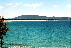
Trial Bay has a northerly facing and is sheltered from the predominant southerly swells. There have been various plans over the years to make it a full harbour, protected in all conditions. Its location in between other sheltered waters of
81:
as more favourable for settlement than Trial Bay, though Trial Bay might offer an anchorage while waiting for favourable winds to cross the bar at Port
Macquarie.
186:
195:
174:
98:
51:
31:
234:
90:
78:
144:
124:
132:
105:
It was also a major internment camp during WWI.<OutBack
Australia Issue 122 Dec 2018/Jan 2019>
93:
recommended such a project. In the 1880s through to 1900s an attempt at a breakwater was made off
47:
170:
128:
35:
228:
94:
55:
43:
66:
86:
145:"Site assessment survey for marine aquaculture facilities on the NSW coastline"
74:
210:
197:
121:
39:
187:
Zivil Lager (Internment Camp): World War One
Prisoners Of War At Trial Bay
19:
62:
97:. In the 1960s an oil terminal established near
42:. The bay faces northwards and extends from
8:
18:
114:
70:which was shipwrecked there in 1816.
7:
14:
16:Bay in New South Wales, Australia
77:explored the area. He reported
50:to the west, past the town of
1:
61:The bay is named after the
251:
235:Bays of New South Wales
169:, Marie H. Neil, 1972,
46:in the east around to
30:is a broad bay on the
24:
167:Valley of the Macleay
22:
133:Geoscience Australia
207: /
189:(online exhibition)
211:30.867°S 153.050°E
127:2007-10-01 at the
25:
242:
222:
221:
219:
218:
217:
216:-30.867; 153.050
212:
208:
205:
204:
203:
200:
159:
158:
156:
155:
149:
141:
135:
119:
99:South West Rocks
52:South West Rocks
250:
249:
245:
244:
243:
241:
240:
239:
225:
224:
215:
213:
209:
206:
201:
198:
196:
194:
193:
183:
163:
162:
153:
151:
150:. November 2003
147:
143:
142:
138:
129:Wayback Machine
120:
116:
111:
36:New South Wales
32:Mid North Coast
17:
12:
11:
5:
248:
246:
238:
237:
227:
226:
191:
190:
182:
181:External links
179:
178:
177:
161:
160:
136:
122:Trial Bay page
113:
112:
110:
107:
79:Port Macquarie
15:
13:
10:
9:
6:
4:
3:
2:
247:
236:
233:
232:
230:
223:
220:
188:
185:
184:
180:
176:
175:0-85587-037-0
172:
168:
165:
164:
146:
140:
137:
134:
130:
126:
123:
118:
115:
108:
106:
103:
100:
96:
95:Laggers Point
92:
91:Port Stephens
88:
82:
80:
76:
71:
69:
68:
64:
59:
57:
56:Macleay River
53:
49:
45:
44:Laggers Point
41:
37:
33:
29:
21:
192:
166:
152:. Retrieved
139:
117:
104:
83:
72:
65:
60:
27:
26:
214: /
87:Moreton Bay
48:Grassy Head
154:2014-08-01
109:References
75:John Oxley
40:Australia
28:Trial Bay
23:Trial Bay
229:Category
202:153°03′E
125:Archived
73:In 1820
54:and the
199:30°52′S
58:mouth.
173:
148:(PDF)
67:Trial
171:ISBN
89:and
63:brig
131:at
34:of
231::
38:,
157:.
Text is available under the Creative Commons Attribution-ShareAlike License. Additional terms may apply.