38:
766:, or calculate, the position of a point inside a triangle using the angles cast between the vertices at the unknown point. These could be measured much more accurately than bearings of the vertices, which depended on a compass. This established the key idea of surveying a large-scale primary network of control points first, and then locating secondary subsidiary points later, within that primary network.
109:
530:
559:
96:. Surveying error is minimized if a mesh of triangles at the largest appropriate scale is established first. Points inside the triangles can all then be accurately located with reference to it. Such triangulation methods were used for accurate large-scale land surveying until the rise of
548:
720:
may have used rough-and-ready triangulation to place features in his county maps of the 1570s; but others suppose that, having obtained rough bearings to features from key vantage points, he may have estimated the distances to them simply by guesswork.
355:
794:. Thanks to improvements in instruments and accuracy, Picard's is rated as the first reasonably accurate measurement of the radius of the earth. Over the next century this work was extended most notably by the Cassini family: between 1683 and 1718
821:
Triangulation methods were by now well established for local mapmaking, but it was only towards the end of the 18th century that other countries began to establish detailed triangulation network surveys to map whole countries. The
516:
434:
254:
623:
and the distances between various places. Simplified Roman techniques then seem to have co-existed with more sophisticated techniques used by professional surveyors. But it was rare for such methods to be
680:, producing an estate plan of the island in 1584. In England Frisius's method was included in the growing number of books on surveying which appeared from the middle of the century onwards, including
521:
From this, it is easy to determine the distance of the unknown point from either observation point, its north/south and east/west offsets from the observation point, and finally its full coordinates.
747:, approximately 72 miles (116 kilometres), using a chain of quadrangles containing 33 triangles in all. Snell underestimated the distance by 3.5%. The two towns were separated by one degree on the
632:
is a rare exception), and such techniques appear to have percolated only slowly into the rest of Europe. Increased awareness and use of such techniques in Spain may be attested by the medieval
1503:
1143:
269:
263:
tan α = sin α / cos α and sin(α + β) = sin α cos β + cos α sin β, this is equivalent to:
1151:
884:
established since the 1980s, but many of the control points for the earlier surveys still survive as valued historical features in the landscape, such as the concrete
181:
1519:
1134:
445:
363:
1511:
823:
1016:
762:), published in 1617. Snell calculated how the planar formulae could be corrected to allow for the curvature of the earth. He also showed how to
625:
197:
1106:
811:
751:, so from his measurement he was able to calculate a value for the circumference of the earth – a feat celebrated in the title of his book
909:
93:
881:
97:
1091:
993:
636:, used specifically for measuring angles, which dates from about 1300; and the appearance of accurately surveyed coastlines in the
137:
The position of any vertex of a triangle can be calculated if the position of one side, and two angles, are known. The following
1217:
889:
1127:
1422:
1309:
1232:
693:
31:
1417:
1034:
838:
and the other
Himalayan peaks, was begun in 1801. For the Napoleonic French state, the French triangulation was extended by
763:
1278:
1612:
919:
668:. This became very influential, and the technique spread across Germany, Austria and the Netherlands. The astronomer
1617:
1468:
604:
158:
1120:
831:
730:
115:
Triangulation may be used to find the position of the ship when the positions of A and B are known. An observer at
1627:
795:
1376:
1037:", in Hannes Palang (ed), European Rural Landscapes: Persistence and Change in a Globalising Environment, p.210
1021:
260:
1319:
92:
known points, but measured at the new unknown point rather than the previously fixed points, a problem called
935:
864:
37:
1047:
350:{\displaystyle \ell =d\left({\frac {\cos \alpha }{\sin \alpha }}+{\frac {\cos \beta }{\sin \beta }}\right)}
1535:
1112:
945:
859:
154:
142:
597:
In the field, triangulation methods were apparently not used by the Roman specialist land surveyors, the
73:. The point can then be fixed as the third point of a triangle with one known side and two known angles.
981:
950:
874:
652:
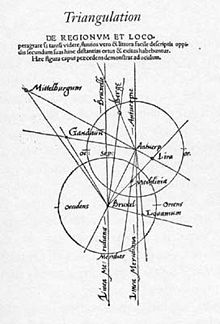
proposed using triangulation to accurately position far-away places for map-making in his 1533 pamphlet
141:
are strictly correct only for a flat surface. If the curvature of the Earth must be allowed for, then
1566:
1350:
1257:
851:
847:
839:
748:
818:, leading to the publication in 1745 of the first map of France constructed on rigorous principles.
1583:
1554:
1542:
1171:
1011:
1007:
897:
893:
736:
735:
The modern systematic use of triangulation networks stems from the work of the Dutch mathematician
85:
1622:
1391:
1314:
1288:
1212:
855:
717:
1473:
1427:
672:
applied the method in
Scandinavia, completing a detailed triangulation in 1579 of the island of
1458:
1181:
1102:
1087:
989:
880:
Today, large-scale triangulation networks for positioning have largely been superseded by the
681:
620:
616:
927:, where a point is calculated using the time-difference-of-arrival between other known points
1528:
1489:
1207:
1202:
633:
583:
166:
1345:
924:
827:
799:
637:
814:
undertook the first triangulation of the whole country, including a re-surveying of the
676:, where his observatory was based, with reference to key landmarks on both sides of the
1607:
1360:
1197:
779:
587:
1601:
1560:
1381:
1340:
1252:
870:
835:
701:
649:
612:
551:
70:
42:
17:
1386:
1355:
1247:
1242:
1166:
1099:
Full
Meridian of Glory: Perilous Adventures in the Competition to Measure the Earth
815:
758:
599:
543:), How to measure the height of a sea island. Illustration from an edition of 1726
88:
in 1615–17, who showed how a point could be located from the angles subtended from
66:
108:
562:
Nineteenth-century triangulation network for the triangulation of
Rhineland-Hesse
1396:
914:
775:
709:
673:
669:
661:
547:
529:
511:{\displaystyle d=\ell \ {\frac {\sin \alpha \sin \beta }{\sin(\alpha +\beta )}}}
429:{\displaystyle \ell =d\ {\frac {\sin(\alpha +\beta )}{\sin \alpha \sin \beta }}}
558:
1335:
1237:
1176:
1084:
The Great Arc: The
Dramatic Tale of How India Was Mapped and Everest Was Named
960:
955:
885:
677:
579:
571:
1463:
1273:
1222:
940:
843:
807:
608:
575:
567:
77:
54:
1432:
1283:
1227:
930:
138:
249:{\displaystyle \ell ={\frac {d}{\tan \alpha }}+{\frac {d}{\tan \beta }}}
61:
is the process of determining the location of a point by measuring only
1442:
1437:
1293:
803:
787:
740:
533:
1401:
846:
from 1801, subsequently completed after 1815 by the
Prussian general
791:
591:
46:
27:
Using measures of converging rays to improve fixed points for mapping
1071:
Maps and their Makers: An
Introduction to the History of Cartography
65:
to it from known points at either end of a fixed baseline by using
1548:
1066:; revised and enlarged by R.A. Skelton. Harvard University Press.
1035:
Tycho Brahe, Cartography and
Landscape in 16th Century Scandinavia
783:
744:
557:
546:
528:
120:
62:
36:
1116:
873:
to find the best fit solution for problems of large systems of
854:
was entrusted from 1821 to 1825 with the triangulation of the
69:, rather than measuring distances to the point directly as in
988:, London: Croom Helm & La Salle, Illinois: Open Court.
1078:
A History of
Cartography: 2500 Years of Maps and Mapmakers
782:
using a chain of thirteen triangles stretching north from
778:
who in 1669–70 surveyed one degree of latitude along the
566:
Triangulation today is used for many purposes, including
986:
A History of
Engineering in Classical and Medieval Times
892:(1936–1962), or the triangulation points set up for the
660:), which he bound in as an appendix in a new edition of
1144:
Geography and cartography in the medieval Islamic world
619:(d. 1048) also introduced triangulation techniques to
640:, the earliest of which that survives is dated 1296.
448:
366:
272:
200:
169:
1576:
1502:
1482:
1451:
1410:
1369:
1328:
1302:
1266:
1190:
1159:
1150:
554:'s 1533 proposal to use triangulation for mapmaking
877:given more real-world measurements than unknowns.
830:in 1783, though not completed until 1853; and the
603:; but were introduced into medieval Spain through
510:
428:
349:
248:
175:
810:; and between 1733 and 1740 Jacques and his son
802:surveyed the whole of the Paris meridian from
1128:
658:Booklet concerning a way of describing places
76:Triangulation can also refer to the accurate
8:
834:of India, which ultimately named and mapped
628:(a manual on geometry, the eleventh century
1012:"Abu Arrayhan Muhammad ibn Ahmad al-Biruni"
80:of systems of very large triangles, called
1156:
1135:
1121:
1113:
654:Libellus de Locorum describendorum ratione
739:, who in 1615 surveyed the distance from
461:
447:
379:
365:
316:
287:
271:
228:
207:
199:
168:
824:Principal Triangulation of Great Britain
690:Treatise of Measuring All Kinds of Lands
107:
1017:MacTutor History of Mathematics Archive
971:
896:(1816–1855), now scheduled as a UNESCO
1076:Tooley, R.V. & Bricker, C. (1969)
977:
975:
706:Geometrical Practise named Pantometria
7:
882:global navigation satellite systems
716:(1607). It has been suggested that
98:global navigation satellite systems
25:
774:Snell's methods were taken up by
84:. This followed from the work of
1218:Abu Muhammad al-Hasan al-Hamdani
1046:Martin and Jean Norgate (2003),
890:retriangulation of Great Britain
910:Anglo-French Survey (1784–1790)
850:. Meanwhile, the mathematician
1233:Khashkhash Ibn Saeed Ibn Aswad
502:
490:
400:
388:
32:Triangulation (disambiguation)
1:
1048:Saxton's Hampshire: Surveying
621:measure the size of the Earth
537:
920:Great Trigonometrical Survey
1469:Mir Ahmed Nasrallah Thattvi
869:), on which he applied the
183:being the distance between
159:inverse Pythagorean theorem
1644:
1521:Book of Roads and Kingdoms
1513:Book of Roads and Kingdoms
1086:. London: Harper Collins.
1050:, University of Portsmouth
832:Great Trigonometric Survey
728:
688:(1559), Valentine Leigh's
648:On land, the cartographer
630:Geomatria incerti auctoris
152:
29:
1418:Abd-al-Razzāq Samarqandī
1022:University of St Andrews
261:trigonometric identities
126:, while the observer at
1033:Michael Jones (2004), "
936:Resection (orientation)
871:method of least squares
731:Snellius' triangulation
1536:Kitab al-Rawd al-Mitar
1423:Ghiyāth al-dīn Naqqāsh
1064:History of Cartography
946:Spherical trigonometry
875:simultaneous equations
796:Jean-Dominique Cassini
563:
555:
544:
512:
430:
351:
250:
177:
155:Geometric mean theorem
143:spherical trigonometry
112:
82:triangulation networks
50:
1320:Abu'l Abbas al-Hijazi
982:Donald Routledge Hill
951:Stellar triangulation
886:triangulation pillars
786:to the clocktower of
686:Cosmographical Glasse
664:'s best-selling 1524
626:translated into Latin
590:and gun direction of
561:
550:
532:
513:
431:
352:
251:
178:
176:{\displaystyle \ell }
111:
40:
18:Triangulation network
1351:Ibn Said al-Maghribi
1069:Crone, G.R. (1978 )
1008:Robertson, Edmund F.
860:Gaussian land survey
852:Carl Friedrich Gauss
840:Jean-Joseph Tranchot
770:Further developments
753:Eratosthenes Batavus
446:
364:
270:
198:
167:
30:For other uses, see
1613:Elementary geometry
1555:The Meadows of Gold
1172:Abu Hanifa Dinawari
1006:O'Connor, John J.;
898:World Heritage Site
894:Struve Geodetic Arc
714:Surveyor's Dialogue
698:Rules of Navigation
1618:Euclidean geometry
1392:Hamdallah Mustawfi
1315:Muhammad al-Idrisi
1289:Mahmud al-Kashgari
1213:Abu Zayd al-Balkhi
1097:Murdin, P. (2009)
1062:Bagrow, L. (1964)
856:kingdom of Hanover
718:Christopher Saxton
611:, such as that by
564:
556:
545:
508:
426:
347:
246:
173:
113:
51:
1595:
1594:
1498:
1497:
1459:Sulaiman Al Mahri
1279:Abu Saʿīd Gardēzī
1258:Qudama ibn Ja'far
1182:Sulaiman al-Tajir
1107:978-0-387-75533-5
848:Karl von Müffling
826:was begun by the
682:William Cuningham
617:Abu Rayhan Biruni
506:
460:
424:
378:
340:
311:
244:
223:
41:Triangulation of
16:(Redirected from
1635:
1628:Geodetic surveys
1543:Mu'jam Al-Buldan
1529:Tabula Rogeriana
1523:(ibn Khordadbeh)
1208:Ahmad ibn Fadlan
1203:Ahmad ibn Rustah
1157:
1137:
1130:
1123:
1114:
1082:Keay, J. (2000)
1051:
1044:
1038:
1031:
1025:
1024:
1003:
997:
979:
868:
842:into the German
737:Willebrord Snell
725:Willebrord Snell
605:Arabic treatises
584:binocular vision
542:
539:
517:
515:
514:
509:
507:
505:
482:
462:
458:
435:
433:
432:
427:
425:
423:
403:
380:
376:
356:
354:
353:
348:
346:
342:
341:
339:
328:
317:
312:
310:
299:
288:
255:
253:
252:
247:
245:
243:
229:
224:
222:
208:
182:
180:
179:
174:
86:Willebrord Snell
21:
1643:
1642:
1638:
1637:
1636:
1634:
1633:
1632:
1598:
1597:
1596:
1591:
1572:
1567:Kitab al-Kharaj
1494:
1478:
1447:
1428:Ahmad ibn Mājid
1406:
1365:
1346:Yaqut al-Hamawi
1324:
1298:
1262:
1186:
1146:
1141:
1059:
1057:Further reading
1054:
1045:
1041:
1032:
1028:
1005:
1004:
1000:
980:
973:
969:
925:Multilateration
906:
862:
828:Ordnance Survey
800:Jacques Cassini
772:
733:
727:
646:
638:Portolan charts
540:
527:
483:
463:
444:
443:
404:
381:
362:
361:
329:
318:
300:
289:
286:
282:
268:
267:
233:
212:
196:
195:
165:
164:
161:
151:
106:
35:
28:
23:
22:
15:
12:
11:
5:
1641:
1639:
1631:
1630:
1625:
1620:
1615:
1610:
1600:
1599:
1593:
1592:
1590:
1589:
1580:
1578:
1574:
1573:
1571:
1570:
1563:
1558:
1551:
1546:
1539:
1532:
1525:
1517:
1508:
1506:
1500:
1499:
1496:
1495:
1493:
1492:
1486:
1484:
1480:
1479:
1477:
1476:
1471:
1466:
1461:
1455:
1453:
1449:
1448:
1446:
1445:
1440:
1435:
1430:
1425:
1420:
1414:
1412:
1408:
1407:
1405:
1404:
1399:
1394:
1389:
1384:
1379:
1373:
1371:
1367:
1366:
1364:
1363:
1361:Ibn al-Mujawir
1358:
1353:
1348:
1343:
1338:
1332:
1330:
1326:
1325:
1323:
1322:
1317:
1312:
1306:
1304:
1300:
1299:
1297:
1296:
1291:
1286:
1281:
1276:
1270:
1268:
1264:
1263:
1261:
1260:
1255:
1250:
1245:
1240:
1235:
1230:
1225:
1220:
1215:
1210:
1205:
1200:
1198:Ibn Khordadbeh
1194:
1192:
1188:
1187:
1185:
1184:
1179:
1174:
1169:
1163:
1161:
1154:
1148:
1147:
1142:
1140:
1139:
1132:
1125:
1117:
1111:
1110:
1095:
1080:
1074:
1067:
1058:
1055:
1053:
1052:
1039:
1026:
998:
970:
968:
965:
964:
963:
958:
953:
948:
943:
938:
933:
928:
922:
917:
912:
905:
902:
780:Paris Meridian
771:
768:
729:Main article:
726:
723:
694:William Bourne
645:
642:
588:model rocketry
526:
523:
519:
518:
504:
501:
498:
495:
492:
489:
486:
481:
478:
475:
472:
469:
466:
457:
454:
451:
437:
436:
422:
419:
416:
413:
410:
407:
402:
399:
396:
393:
390:
387:
384:
375:
372:
369:
358:
357:
345:
338:
335:
332:
327:
324:
321:
315:
309:
306:
303:
298:
295:
292:
285:
281:
278:
275:
257:
256:
242:
239:
236:
232:
227:
221:
218:
215:
211:
206:
203:
172:
150:
147:
145:must be used.
105:
102:
100:in the 1980s.
26:
24:
14:
13:
10:
9:
6:
4:
3:
2:
1640:
1629:
1626:
1624:
1621:
1619:
1616:
1614:
1611:
1609:
1606:
1605:
1603:
1588:
1586:
1582:
1581:
1579:
1575:
1569:
1568:
1564:
1562:
1561:Piri Reis map
1559:
1557:
1556:
1552:
1550:
1547:
1545:
1544:
1540:
1538:
1537:
1533:
1531:
1530:
1526:
1524:
1522:
1518:
1516:
1514:
1510:
1509:
1507:
1505:
1501:
1491:
1490:Evliya Çelebi
1488:
1487:
1485:
1481:
1475:
1472:
1470:
1467:
1465:
1462:
1460:
1457:
1456:
1454:
1450:
1444:
1441:
1439:
1436:
1434:
1431:
1429:
1426:
1424:
1421:
1419:
1416:
1415:
1413:
1409:
1403:
1400:
1398:
1395:
1393:
1390:
1388:
1385:
1383:
1380:
1378:
1375:
1374:
1372:
1368:
1362:
1359:
1357:
1354:
1352:
1349:
1347:
1344:
1342:
1341:Saadi Shirazi
1339:
1337:
1334:
1333:
1331:
1327:
1321:
1318:
1316:
1313:
1311:
1308:
1307:
1305:
1301:
1295:
1292:
1290:
1287:
1285:
1282:
1280:
1277:
1275:
1272:
1271:
1269:
1265:
1259:
1256:
1254:
1253:Al-Ramhormuzi
1251:
1249:
1246:
1244:
1241:
1239:
1236:
1234:
1231:
1229:
1226:
1224:
1221:
1219:
1216:
1214:
1211:
1209:
1206:
1204:
1201:
1199:
1196:
1195:
1193:
1189:
1183:
1180:
1178:
1175:
1173:
1170:
1168:
1165:
1164:
1162:
1158:
1155:
1153:
1149:
1145:
1138:
1133:
1131:
1126:
1124:
1119:
1118:
1115:
1108:
1104:
1100:
1096:
1093:
1092:0-00-257062-9
1089:
1085:
1081:
1079:
1075:
1072:
1068:
1065:
1061:
1060:
1056:
1049:
1043:
1040:
1036:
1030:
1027:
1023:
1019:
1018:
1013:
1009:
1002:
999:
996:. pp. 119–122
995:
994:0-87548-422-0
991:
987:
983:
978:
976:
972:
966:
962:
959:
957:
954:
952:
949:
947:
944:
942:
939:
937:
934:
932:
929:
926:
923:
921:
918:
916:
913:
911:
908:
907:
903:
901:
899:
895:
891:
887:
883:
878:
876:
872:
866:
861:
857:
853:
849:
845:
841:
837:
836:Mount Everest
833:
829:
825:
819:
817:
813:
812:César Cassini
809:
805:
801:
797:
793:
789:
785:
781:
777:
769:
767:
765:
761:
760:
754:
750:
746:
742:
738:
732:
724:
722:
719:
715:
711:
707:
703:
702:Thomas Digges
699:
695:
691:
687:
683:
679:
675:
671:
667:
666:Cosmographica
663:
659:
655:
651:
650:Gemma Frisius
644:Gemma Frisius
643:
641:
639:
635:
634:Jacob's staff
631:
627:
622:
618:
614:
613:Ibn al-Saffar
610:
606:
602:
601:
595:
593:
589:
585:
581:
577:
573:
569:
560:
553:
552:Gemma Frisius
549:
535:
531:
524:
522:
499:
496:
493:
487:
484:
479:
476:
473:
470:
467:
464:
455:
452:
449:
442:
441:
440:
420:
417:
414:
411:
408:
405:
397:
394:
391:
385:
382:
373:
370:
367:
360:
359:
343:
336:
333:
330:
325:
322:
319:
313:
307:
304:
301:
296:
293:
290:
283:
279:
276:
273:
266:
265:
264:
262:
240:
237:
234:
230:
225:
219:
216:
213:
209:
204:
201:
194:
193:
192:
190:
186:
170:
160:
156:
148:
146:
144:
140:
135:
133:
129:
125:
122:
119:measures the
118:
110:
103:
101:
99:
95:
91:
87:
83:
79:
74:
72:
71:trilateration
68:
64:
60:
59:triangulation
56:
48:
44:
43:Kodiak Island
39:
33:
19:
1584:
1565:
1553:
1541:
1534:
1527:
1520:
1512:
1483:17th century
1452:16th century
1411:15th century
1387:Ibn al-Wardi
1370:14th century
1356:Ibn al-Nafis
1329:13th century
1303:12th century
1267:11th century
1248:Al-Muqaddasi
1243:Ibn al-Faqih
1191:10th century
1167:Al-Khwarizmi
1101:. Springer.
1098:
1083:
1077:
1070:
1063:
1042:
1029:
1015:
1001:
985:
879:
820:
816:meridian arc
798:and his son
773:
759:Eratosthenes
756:
752:
734:
713:
708:(1571), and
705:
697:
689:
685:
665:
657:
653:
647:
629:
600:agrimensores
598:
596:
565:
520:
438:
258:
188:
184:
162:
136:
131:
127:
123:
116:
114:
94:resectioning
89:
81:
75:
67:trigonometry
58:
52:
1397:Ibn Battuta
1377:Al-Dimashqi
1160:9th century
1152:Geographers
915:Bilby tower
888:set up for
863: [
776:Jean Picard
710:John Norden
670:Tycho Brahe
662:Peter Apian
615:(d. 1035).
439:therefore:
149:Calculation
1602:Categories
1577:Influences
1515:(al-Bakrī)
1382:Abu'l-Fida
1336:Ibn Jubayr
1238:Ibn Hawqal
967:References
961:Trig point
956:Stereopsis
757:The Dutch
580:astrometry
572:navigation
541: 263
259:Using the
153:See also:
1623:Surveying
1587:(Ptolemy)
1585:Geography
1474:Amīn Rāzī
1464:Piri Reis
1274:Al-Biruni
1223:Al-Masudi
1073:(5th ed).
941:SOCET SET
844:Rhineland
808:Perpignan
764:resection
609:astrolabe
576:metrology
568:surveying
500:β
494:α
488:
480:β
477:
471:α
468:
456:ℓ
421:β
418:
412:α
409:
398:β
392:α
386:
368:ℓ
337:β
334:
326:β
323:
308:α
305:
297:α
294:
274:ℓ
241:β
238:
220:α
217:
202:ℓ
171:ℓ
130:measures
104:Principle
78:surveying
55:surveying
1433:Zheng He
1310:al-Zuhri
1284:Al-Bakri
1228:Istakhri
984:(1984),
931:Parallax
904:See also
749:meridian
700:(1571),
692:(1562),
139:formulae
49:in 1929.
1443:Fei Xin
1438:Ma Huan
1294:Domiyat
1177:Ya'qubi
804:Dunkirk
790:, near
788:Sourdon
741:Alkmaar
678:Øresund
607:on the
592:weapons
534:Liu Hui
525:History
191:gives:
1402:Lin Nu
1105:
1090:
992:
792:Amiens
459:
377:
63:angles
47:Alaska
1608:Angle
1549:Rihla
1504:Works
867:]
784:Paris
745:Breda
163:With
121:angle
90:three
1103:ISBN
1088:ISBN
990:ISBN
674:Hven
187:and
157:and
806:to
743:to
712:'s
704:'s
696:'s
684:'s
485:sin
474:sin
465:sin
415:sin
406:sin
383:sin
331:sin
320:cos
302:sin
291:cos
235:tan
214:tan
53:In
45:in
1604::
1020:,
1014:,
1010:,
974:^
900:.
865:de
594:.
586:,
582:,
578:,
574:,
570:,
538:c.
134:.
57:,
1136:e
1129:t
1122:v
1109:.
1094:.
858:(
755:(
656:(
536:(
503:)
497:+
491:(
453:=
450:d
401:)
395:+
389:(
374:d
371:=
344:)
314:+
284:(
280:d
277:=
231:d
226:+
210:d
205:=
189:B
185:A
132:β
128:B
124:α
117:A
34:.
20:)
Text is available under the Creative Commons Attribution-ShareAlike License. Additional terms may apply.