52:
45:
276:
487:. The westernmost cirque on Eastwind Ridge which is connected to the "dead" western terminus of Towle Glacier. So little ice from Eastwind Ridge enters the cirque that it barely makes any contribution to the west end of the Towle Glacier and arcuate supraglacial moraines remain drifting within the cirque. So named by a 1989-90 NZARP field party to describe the sluggish ice flow of this cirque.
719:
659:
530:. A rocky ridge at the west side of Chattahoochee Glacier. It extends northward from the northwest end of the Convoy Range. Mapped by the USGS from ground surveys and Navy air photos. Named in 1964 by US-ACAN after the USS Wyandot, a cargo vessel in the American convoy to McMurdo Sound in several years beginning with the 1955–56 season.
407:. A mountain, 1,710 metres (5,610 ft) high, which surmounts the east part of Eastwind Ridge. Mapped by USGS from ground swveys and Navy air photos. Named by US-ACAN in 1964 for Captain Joseph Naab, Jr., USCG, commanding officer of the icebreaker Eastwind during 1961 and 1962.
723:
663:
318:
A peak to the north of Mount Naab at the northeast end of
Eastwind Ridge. Named in association with Eastwind Ridge after Captain R.D. Schmidtman, United States Coast Guard (USCG), commander of the icebreaker USCGC
365:
A cirque between Mount
Schmidtman and Mount Naab at the northeast end of Eastwind Ridge. Iceflow from Eastwind Ridge is insufficient to carry surficial moraine away into
84:
449:. One of the nautical names in Convoy Range. The name was applied by a 1989-90 NZARP field party to describe the fastest flowing tributary to Towle Glacier.
709:
688:
667:
647:
44:
445:. A glacial cirque on the south wall of Eastwind Ridge immediately west of Mount Naab. Icefalls at the head provide the main ice flow into the
210:
148:
700:
679:
695:
674:
742:
369:
and moraines lie in a tangled eddy. So named by New
Zealand Geographic Board (NZGB) which also considered the name Eddy Cirque.
727:
705:
684:
206:
337:
77:
290:
502:
459:
417:
379:
237:
324:
186:
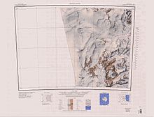
185:) is a broad, partially ice-covered ridge about 10 nautical miles (19 km; 12 mi) long between
747:
264:
259:
275:
254:
214:
736:
446:
221:
190:
133:
59:
638:
194:
209:(USGS) from ground surveys and Navy air photos. It was named by the United States
366:
279:
Eastwind Ridge is in the north of the Convoy Range, in the lower part of the map
249:
517:
504:
474:
461:
432:
419:
394:
381:
352:
339:
305:
292:
164:
150:
100:
86:
17:
274:
544:
542:
129:
124:
76:
71:
32:
560:
220:, an icebreaker in several American convoys into
572:
8:
29:
710:United States Department of the Interior
689:United States Department of the Interior
668:United States Board on Geographic Names
648:United States Board on Geographic Names
620:
608:
596:
584:
548:
538:
51:
211:Advisory Committee on Antarctic Names
7:
701:Geographic Names Information System
680:Geographic Names Information System
726:from websites or documents of the
666:from websites or documents of the
25:
640:Geographic Names of the Antarctic
205:Eastwind Ridge was mapped by the
722: This article incorporates
717:
662: This article incorporates
657:
50:
43:
728:United States Geological Survey
706:United States Geological Survey
685:United States Geological Survey
323:in the Ross Seas Ship Group in
207:United States Geological Survey
637:Alberts, Fred G., ed. (1995),
1:
265:GPX (secondary coordinates)
27:Antarctic ice-covered ridge
764:
353:76.5833333°S 161.0333333°E
224:since the 1958–59 season.
213:(US-ACAN) in 1964 for the
260:GPX (primary coordinates)
235:Map all coordinates using
37:
358:-76.5833333; 161.0333333
243:Download coordinates as:
743:Ridges of Victoria Land
724:public domain material
664:public domain material
280:
201:Exploration and naming
561:Mount Schmidtman USGS
325:Operation Deep Freeze
278:
255:GPX (all coordinates)
187:Chattahoochee Glacier
573:Drifter Cirque USGS
514: /
471: /
429: /
391: /
349: /
302: /
160: /
96: /
696:"Mount Schmidtman"
518:76.600°S 160.500°E
475:76.633°S 160.750°E
433:76.617°S 160.850°E
395:76.600°S 160.933°E
306:76.5666667°S 161°E
281:
165:76.600°S 160.783°E
101:76.600°S 160.783°E
72:Highest point
453:Slackwater Cirque
140:
139:
16:(Redirected from
755:
721:
720:
712:
691:
675:"Drifter Cirque"
661:
660:
656:
655:
654:
645:
624:
618:
612:
606:
600:
594:
588:
582:
576:
570:
564:
558:
552:
546:
529:
528:
526:
525:
524:
523:-76.600; 160.500
519:
515:
512:
511:
510:
507:
486:
485:
483:
482:
481:
480:-76.633; 160.750
476:
472:
469:
468:
467:
464:
444:
443:
441:
440:
439:
438:-76.617; 160.850
434:
430:
427:
426:
425:
422:
406:
405:
403:
402:
401:
400:-76.600; 160.933
396:
392:
389:
388:
387:
384:
364:
363:
361:
360:
359:
354:
350:
347:
346:
345:
342:
317:
316:
314:
313:
312:
311:-76.5666667; 161
307:
303:
300:
299:
298:
295:
284:Mount Schmidtman
184:
183:
181:
180:
179:
177:
172:
171:
170:-76.600; 160.783
166:
161:
158:
157:
156:
153:
120:
119:
117:
116:
115:
113:
108:
107:
106:-76.600; 160.783
102:
97:
94:
93:
92:
89:
54:
53:
47:
30:
21:
763:
762:
758:
757:
756:
754:
753:
752:
733:
732:
718:
715:
694:
673:
658:
652:
650:
643:
636:
632:
627:
619:
615:
607:
603:
595:
591:
583:
579:
571:
567:
559:
555:
547:
540:
536:
522:
520:
516:
513:
508:
505:
503:
501:
500:
498:
493:
491:Nearby features
479:
477:
473:
470:
465:
462:
460:
458:
457:
455:
437:
435:
431:
428:
423:
420:
418:
416:
415:
413:
399:
397:
393:
390:
385:
382:
380:
378:
377:
375:
357:
355:
351:
348:
343:
340:
338:
336:
335:
333:
310:
308:
304:
301:
296:
293:
291:
289:
288:
286:
273:
272:
271:
270:
269:
230:
203:
197:of Antarctica.
175:
173:
169:
167:
163:
162:
159:
154:
151:
149:
147:
146:
111:
109:
105:
103:
99:
98:
95:
90:
87:
85:
83:
82:
67:
66:
65:
64:
63:
57:
56:
55:
28:
23:
22:
15:
12:
11:
5:
761:
759:
751:
750:
745:
735:
734:
714:
713:
692:
671:
646:(2 ed.),
633:
631:
628:
626:
625:
623:, p. 825.
613:
611:, p. 683.
601:
599:, p. 620.
589:
587:, p. 515.
577:
565:
553:
551:, p. 209.
537:
535:
532:
497:
494:
492:
489:
454:
451:
412:
411:Riptide Cirque
409:
374:
371:
332:
331:Drifter Cirque
329:
285:
282:
268:
267:
262:
257:
252:
246:
240:
233:
232:
231:
229:
226:
202:
199:
176:Eastwind Ridge
143:Eastwind Ridge
138:
137:
131:
127:
126:
122:
121:
112:Eastwind Ridge
80:
74:
73:
69:
68:
58:
49:
48:
42:
41:
40:
39:
38:
35:
34:
33:Eastwind Ridge
26:
24:
14:
13:
10:
9:
6:
4:
3:
2:
760:
749:
746:
744:
741:
740:
738:
731:
729:
725:
711:
707:
703:
702:
697:
693:
690:
686:
682:
681:
676:
672:
669:
665:
649:
642:
641:
635:
634:
629:
622:
617:
614:
610:
605:
602:
598:
593:
590:
586:
581:
578:
574:
569:
566:
562:
557:
554:
550:
545:
543:
539:
533:
531:
527:
496:Wyandot Ridge
495:
490:
488:
484:
452:
450:
448:
447:Towle Glacier
442:
410:
408:
404:
372:
370:
368:
362:
330:
328:
326:
322:
315:
283:
277:
266:
263:
261:
258:
256:
253:
251:
248:
247:
245:
244:
239:
238:OpenStreetMap
236:
227:
225:
223:
222:McMurdo Sound
219:
218:
212:
208:
200:
198:
196:
192:
191:Towle Glacier
188:
182:
144:
135:
134:Victoria Land
132:
128:
123:
118:
81:
79:
75:
70:
61:
60:Victoria Land
46:
36:
31:
19:
18:Wyandot Ridge
716:
699:
678:
651:, retrieved
639:
621:Alberts 1995
616:
609:Alberts 1995
604:
597:Alberts 1995
592:
585:Alberts 1995
580:
568:
556:
549:Alberts 1995
499:
456:
414:
376:
334:
320:
287:
242:
241:
234:
216:
204:
195:Convoy Range
142:
141:
136:, Antarctica
62:, Antarctica
748:Scott Coast
521: /
478: /
436: /
398: /
367:Fry Glacier
356: /
344:161°02′00″E
309: /
297:161°00′00″E
168: /
104: /
78:Coordinates
737:Categories
653:2024-01-30
534:References
373:Mount Naab
341:76°35′00″S
294:76°34′00″S
174: (
110: (
125:Geography
509:160°30′E
466:160°45′E
424:160°51′E
386:160°56′E
327:, 1960.
321:Eastwind
228:Features
217:Eastwind
155:160°47′E
130:Location
91:160°47′E
630:Sources
506:76°36′S
463:76°38′S
421:76°37′S
383:76°36′S
193:in the
152:76°36′S
88:76°36′S
215:USCGC
644:(PDF)
189:and
250:KML
739::
730:.
708:,
704:,
698:,
687:,
683:,
677:,
541:^
670:.
575:.
563:.
178:)
145:(
114:)
20:)
Text is available under the Creative Commons Attribution-ShareAlike License. Additional terms may apply.