120:
710:
135:. A walking track runs from the car park at the end of Goodwin Road, up the valley of the stream to a viewing platform, and thence to the top of the plateau and the crest of the falls. Once at the top one can continue onto the North South track that runs the length of the Kaimai Ranges. The track is about 5 km (3.1 mi) return to the lower lookout and climbs about 380 m (1,250 ft) from Goodwin Road to the top of the falls.
637:
44:
653:
138:
The
Wairere Falls receives around 60,000 visitors each year. In 2017, the farmer who owned land close to the falls closed off a paddock to stock and constructed a seat for visitors that he dubbed "The international seat of peace".
142:
A road from Te Aroha to the falls was built between 1886 and 1892, when a coach service was started. It was extended about 1915. In 1903 the falls were considered for hydro power, but were protected by declaration as a
591:
266:
215:
523:
540:
751:
472:
522:
Adrian
Pittari, Marlena L. Prentice, Oliver E. McLeod, Elham Yousef Zadeh, Peter J. J. Kamp, Martin Danišík & Kirsty A. Vincent (3 December 2020).
343:
694:
317:
253:
606:
571:
195:. A deed of settlement between Ngāti Hinerangi and the Crown, redressing some of the unjust Crown actions, was signed on 4 May 2019.
554:
524:"Inception of the modern North Island (New Zealand) volcanic setting: spatio-temporal patterns of volcanism between 3.0 and 0.9 Ma"
790:
780:
770:
744:
144:
687:
775:
737:
785:
155:
119:
680:
123:
Wairere Falls in April 2010 (upper lookout to right) and May 2023 (after heavy rain) from the lower lookout
597:
93:
188:
24:
420:
394:
368:
168:
446:
241:
534:
249:
184:
709:
291:
721:
664:
498:
764:
151:
113:
109:
105:
65:
20:
636:
162:
621:
608:
660:
192:
72:
43:
132:
128:
717:
652:
180:
61:
172:
159:
318:"Waikato farmer closes popular tourist attraction at Wairere Falls"
635:
118:
176:
473:"Reserves made in 1908-9 under the Scenery Preservation Acts"
171:
value Te
Wairere Falls as the place where an early explorer,
344:"The man behind Wairere Falls' international seat of peace"
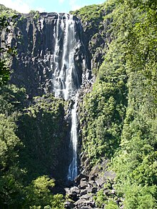
112:, plunges 153 metres (500 feet) in two steps over the
555:"Deed of Settlement between Ngāti Hinerangi and the Crown"
19:
For
Wairere Falls and power station in King Country, see
725:
668:
216:"Waikato offers mighty good fun these school holidays"
256:. Updated 21 September 2007. Retrieved 22 May 2009.
89:
81:
71:
57:
36:
183:. They used the Wairere track during the 1864
745:
688:
165:. The rock was erupted about 2.1m years ago.
8:
539:: CS1 maint: multiple names: authors list (
23:. For Wairere Falls near Lake Tarawera, see
150:The Kaimai Range's western boundary is the
752:
738:
695:
681:
42:
33:
421:"Matamata County Council. Te Aroha News"
246:Te Ara – the Encyclopedia of New Zealand
179:, to use for food on his voyage back to
204:
48:Wairere Falls from the viewing platform
532:
395:"THE WAIRERE FALLS. Thames Advertiser"
210:
208:
154:. This part of the Range is formed of
369:"PIAKO COUNTY COUNCIL. Te Aroha News"
316:Blommerde, Chloe (22 November 2020).
248:, Ministry for Culture and Heritage.
7:
706:
704:
649:
647:
572:"Ngāti Hinerangi deed of settlement"
500:Rotorua 1 to 250,000 geological map
14:
242:Waterfalls – Causes of waterfalls
127:The waterfall is located between
16:Waterfall in Waikato, New Zealand
708:
651:
447:"Local and General. Thames Star"
342:Hope, Sharnae (17 March 2020).
191:gave ownership of the falls to
88:
80:
640:View from the top of the falls
1:
724:. You can help Knowledge by
667:. You can help Knowledge by
594:, Department of Conservation
104:, the highest waterfall in
807:
703:
646:
158:, a crystal-rich, welded,
18:
477:paperspast.natlib.govt.nz
451:paperspast.natlib.govt.nz
425:paperspast.natlib.govt.nz
399:paperspast.natlib.govt.nz
373:paperspast.natlib.govt.nz
53:
41:
600:of the hike to the falls
292:"Wairere Falls, Waikato"
791:Waikato geography stubs
720:geography article is a
781:Waihou River catchment
663:-related article is a
641:
124:
771:Waterfalls of Waikato
639:
267:"Wairere Falls Track"
147:on 12 November 1908.
122:
156:Waiteariki Formation
618: /
592:Wairere Falls Track
187:. In July 1896 the
25:Te Wairoa (village)
642:
125:
733:
732:
676:
675:
622:37.734°S 175.88°E
453:. 16 October 1903
375:. 4 December 1886
254:978-0-478-18451-8
189:Native Land Court
185:Tauranga campaign
114:Kaimai escarpment
99:
98:
798:
754:
747:
740:
712:
705:
697:
690:
683:
655:
648:
633:
632:
630:
629:
628:
623:
619:
616:
615:
614:
611:
579:
578:
576:
568:
562:
561:
559:
551:
545:
544:
538:
530:
528:
519:
513:
512:
510:
508:
503:(Map). GNS. 2010
495:
489:
488:
486:
484:
469:
463:
462:
460:
458:
443:
437:
436:
434:
432:
417:
411:
410:
408:
406:
391:
385:
384:
382:
380:
365:
359:
358:
356:
354:
339:
333:
332:
330:
328:
313:
307:
306:
304:
302:
288:
282:
281:
279:
277:
263:
257:
238:
232:
231:
229:
227:
212:
46:
34:
806:
805:
801:
800:
799:
797:
796:
795:
786:Waterfall stubs
776:Ngāti Hinerangi
761:
760:
759:
758:
702:
701:
644:
627:-37.734; 175.88
626:
624:
620:
617:
612:
609:
607:
605:
604:
588:
583:
582:
574:
570:
569:
565:
557:
553:
552:
548:
531:
526:
521:
520:
516:
506:
504:
497:
496:
492:
482:
480:
471:
470:
466:
456:
454:
445:
444:
440:
430:
428:
419:
418:
414:
404:
402:
401:. 10 March 1892
393:
392:
388:
378:
376:
367:
366:
362:
352:
350:
341:
340:
336:
326:
324:
315:
314:
310:
300:
298:
290:
289:
285:
275:
273:
271:www.doc.govt.nz
265:
264:
260:
240:Jock Phillips.
239:
235:
225:
223:
214:
213:
206:
201:
169:Ngāti Hinerangi
49:
28:
17:
12:
11:
5:
804:
802:
794:
793:
788:
783:
778:
773:
763:
762:
757:
756:
749:
742:
734:
731:
730:
713:
700:
699:
692:
685:
677:
674:
673:
656:
602:
601:
595:
587:
586:External links
584:
581:
580:
563:
546:
529:. p. 257.
514:
490:
464:
438:
412:
386:
360:
334:
308:
283:
258:
233:
203:
202:
200:
197:
145:Scenic Reserve
97:
96:
94:Wairere Stream
91:
87:
86:
83:
79:
78:
75:
69:
68:
59:
55:
54:
51:
50:
47:
39:
38:
15:
13:
10:
9:
6:
4:
3:
2:
803:
792:
789:
787:
784:
782:
779:
777:
774:
772:
769:
768:
766:
755:
750:
748:
743:
741:
736:
735:
729:
727:
723:
719:
714:
711:
707:
698:
693:
691:
686:
684:
679:
678:
672:
670:
666:
662:
657:
654:
650:
645:
638:
634:
631:
599:
596:
593:
590:
589:
585:
577:. 4 May 2019.
573:
567:
564:
560:. 4 May 2019.
556:
550:
547:
542:
536:
525:
518:
515:
502:
501:
494:
491:
478:
474:
468:
465:
452:
448:
442:
439:
427:. 4 June 1915
426:
422:
416:
413:
400:
396:
390:
387:
374:
370:
364:
361:
349:
345:
338:
335:
323:
319:
312:
309:
297:
293:
287:
284:
272:
268:
262:
259:
255:
251:
247:
243:
237:
234:
222:. 2 July 2022
221:
217:
211:
209:
205:
198:
196:
194:
190:
186:
182:
178:
174:
170:
166:
164:
161:
157:
153:
152:Hauraki Fault
148:
146:
140:
136:
134:
130:
121:
117:
115:
111:
107:
103:
102:Wairere Falls
95:
92:
84:
76:
74:
70:
67:
63:
60:
56:
52:
45:
40:
37:Wairere Falls
35:
32:
30:
26:
22:
726:expanding it
715:
669:expanding it
658:
643:
603:
566:
549:
517:
505:. Retrieved
499:
493:
481:. Retrieved
476:
467:
455:. Retrieved
450:
441:
429:. Retrieved
424:
415:
403:. Retrieved
398:
389:
377:. Retrieved
372:
363:
351:. Retrieved
347:
337:
325:. Retrieved
321:
311:
299:. Retrieved
295:
286:
274:. Retrieved
270:
261:
245:
236:
224:. Retrieved
219:
167:
149:
141:
137:
126:
110:North Island
101:
100:
82:Total height
31:
29:
625: /
613:175°52′48″E
296:NZ Topo Map
175:, killed a
106:New Zealand
90:Watercourse
66:New Zealand
21:Mokau River
765:Categories
610:37°44′02″S
598:Flickr set
199:References
163:ignimbrite
661:waterfall
220:NZ Herald
193:the Crown
535:cite web
133:Matamata
129:Te Aroha
58:Location
718:Waikato
353:20 July
327:20 July
226:20 July
181:Hawaiki
62:Waikato
507:15 May
483:14 May
479:. 1909
457:14 May
431:14 May
405:14 May
379:14 May
301:14 May
276:14 May
252:
173:Ngahue
160:dacite
77:Tiered
716:This
659:This
575:(PDF)
558:(PDF)
527:(PDF)
348:Stuff
322:Stuff
722:stub
665:stub
541:link
509:2023
485:2023
459:2023
433:2023
407:2023
381:2023
355:2022
329:2022
303:2023
278:2023
250:ISBN
228:2022
131:and
85:153m
73:Type
177:moa
108:'s
767::
537:}}
533:{{
475:.
449:.
423:.
397:.
371:.
346:.
320:.
294:.
269:.
244:,
218:.
207:^
116:.
64:,
753:e
746:t
739:v
728:.
696:e
689:t
682:v
671:.
543:)
511:.
487:.
461:.
435:.
409:.
383:.
357:.
331:.
305:.
280:.
230:.
27:.
Text is available under the Creative Commons Attribution-ShareAlike License. Additional terms may apply.