31:
47:
54:
345:
Before it was combined with
Brandon on 1 April 2015, the parish consisted of only a few scattered buildings including a church and 16th century hall and had one of the lowest populations of any parish in Suffolk with only seven residents at the 2001 census. In 2015 the parish was formally combined
541:
431:
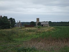
and lies close to the end of the runway of RAF Lakenheath. The church has a medieval core although it was restored in the 19th century. It features 12th century doorways and a 14th-century tower and is a Grade II*
354:
There is evidence of the parish being populated since prehistoric times. Palaeolithic tools such as handaxes, arrowheads and flint scrapers have been found in the parish and there is also evidence of
230:
138:
93:
573:
782:
452:
Wangford Hall lies to the south of the church immediately adjacent to the airbase boundary fences. It dates from the 16th century and was the home of
238:
377:
A Saxon inhumation burial has also been discovered in the parish. Glass and amber beads and a bronze gilded 'hinged handle' from the site are in the
220:
274:
500:
located in the former parish area. It features areas of inland sand dune, heathland and carr and includes areas of the rare grey hair-grass
30:
334:
airbase is west of the former parish area with the main runway extending into it. Wangford is located around 2 miles (3.2 km) east of
497:
457:
408:
382:
256:
208:
174:
46:
411:
operated base, was built beginning in 1940, initially as a decoy airfield. In the post war period it was used initially as an
465:
517:
runs through the former parish area cutting it in two. To the south-east of the A1065 much the area of the former parish is
86:
777:
715:
507:
396:
and had 29 households. In the mid 19th century the parish had a population of 48 and in 1881 the population was 56.
730:
787:
473:
266:
261:
758:
436:. The church became redundant in the 1970s and has been cared for by the New Beginnings International Church, a
493:
188:
742:
319:
128:
502:
453:
428:
120:
510:, and includes areas which fall within the Breckland Farmland SSSI and Breckland Forest SSSI units.
518:
461:
469:
156:
683:
637:
621:
605:
589:
437:
404:
393:
315:
213:
110:
370:(AD 253-68), was discovered in a jar on Wangford Heath. The jar is in Moyse's Hall Museum,
746:
522:
433:
371:
164:
576:, The Local Government Boundary Commission for England, 2014-10-27. Retrieved 2017-07-02
574:
The Forest Heath
District (Reorganisation of Community Governance) (Wangford) Order 2014
400:
378:
359:
331:
323:
700:
665:
771:
633:
617:
601:
585:
561:
389:
311:
102:
649:
514:
339:
335:
289:
276:
489:
367:
366:
of 3000 silver and bronze coins, dating from the reign of the Roman
Emperor
198:
699:
Kelly's
Directory for Cambridgeshire, Norfolk & Suffolk, 1883, p.1050.
355:
477:
327:
180:
146:
67:
480:. The hall and a barn and stable range are Grade II listed buildings.
363:
441:
416:
399:
The western edge of the parish was used as part of the site of
412:
338:
and 3 miles (4.8 km) south-west of
Brandon, close to the
761:, Joint Nature Conservation Committee. Retrieved 2014-03-03.
506:. Much of the former parish area is within the Breckland
544:
472:
from 1689 to 1710. In the 19th century it was owned by
229:
219:
207:
197:
187:
173:
155:
137:
119:
101:
85:
77:
23:
415:base with operational command transferring to the
733:, British Listed Buildings. Retrieved 2014-03-03.
718:, British Listed Buildings. Retrieved 2014-03-03.
564:, Suffolk churches website. Retrieved 2014-03-03.
711:
709:
392:Wangford was recorded as Wamforda. It was in
8:
695:
693:
557:
555:
553:
342:. In 2001 the parish had a population of 7.
726:
724:
407:. The airfield, which is still in use as a
20:
534:
228:
196:
172:
84:
27:
542:Office for National Statistics :
684:A Topographical Dictionary of England
218:
206:
186:
154:
136:
118:
7:
687:, pp. 457-461. Retrieved 2014-03-03.
498:Site of Special Scientific Interest
381:and a large cruciform brooch is in
427:The parish church is dedicated to
409:United States Air Forces in Europe
14:
383:Birmingham Museum and Art Gallery
783:Former civil parishes in Suffolk
53:
52:
45:
29:
1:
440:church group from the nearby
374:, but the coins are missing.
716:Church of St Denis, Wangford
521:plantation, forming part of
508:Special Area of Conservation
701:Transcript available online
87:OS grid reference
18:Human settlement in England
804:
346:with the town of Brandon.
35:St Denis' church, Wangford
247:
40:
28:
743:Wangford Warren and Carr
494:Wangford Warren and Carr
310:is a village and former
749:. Retrieved 2013-03-03.
731:Wangford Hall, Wangford
681:Lewis,Samuel A. (1848)
672:. Retrieved 2014-03-04.
656:. Retrieved 2014-03-04.
650:Wangford (near Brandon)
640:. Retrieved 2014-03-04.
624:. Retrieved 2014-03-04.
608:. Retrieved 2014-03-04.
592:. Retrieved 2014-03-04.
488:Wangford is within the
476:the industrialist from
456:, Chief Justice of the
314:, now in the parish of
703:. Retrieved 2014-03-03
503:Corynephorus canescens
209:Postcode district
547:Retrieved 2012-01-27.
458:Court of King's Bench
422:
654:Domesday book online
189:Sovereign state
778:Villages in Suffolk
634:Monument No. 380296
618:Monument No. 380287
602:Monument No. 380285
586:Monument No. 380305
519:Forestry Commission
286: /
562:St Denis, Wangford
470:Lord Chief Justice
231:UK Parliament
221:Dialling code
745:, SSSI citation,
454:Sir Robert Wright
305:
304:
139:Shire county
795:
788:Brandon, Suffolk
762:
756:
750:
740:
734:
728:
719:
713:
704:
697:
688:
679:
673:
663:
657:
647:
641:
638:English Heritage
631:
625:
622:English Heritage
615:
609:
606:English Heritage
599:
593:
590:English Heritage
583:
577:
571:
565:
559:
548:
539:
438:Southern Baptist
423:St Denis' church
405:Second World War
394:Lackford Hundred
362:inhabitation. A
322:district of the
301:
300:
298:
297:
296:
291:
290:52.422°N 0.572°E
287:
284:
283:
282:
279:
253:
183:
97:
96:
66:Location within
56:
55:
49:
33:
21:
803:
802:
798:
797:
796:
794:
793:
792:
768:
767:
766:
765:
757:
753:
747:Natural England
741:
737:
729:
722:
714:
707:
698:
691:
680:
676:
664:
660:
648:
644:
632:
628:
616:
612:
600:
596:
584:
580:
572:
568:
560:
551:
540:
536:
531:
523:Thetford Forest
486:
474:Richard Garrett
450:
434:listed building
425:
390:Domesday survey
372:Bury St Edmunds
352:
294:
292:
288:
285:
280:
277:
275:
273:
272:
271:
251:
243:
179:
169:
151:
133:
115:
92:
91:
73:
72:
71:
70:
64:
63:
62:
61:
57:
36:
19:
12:
11:
5:
801:
799:
791:
790:
785:
780:
770:
769:
764:
763:
751:
735:
720:
705:
689:
674:
658:
642:
626:
610:
594:
578:
566:
549:
533:
532:
530:
527:
485:
482:
449:
446:
424:
421:
401:RAF Lakenheath
379:British Museum
360:Romano-British
351:
348:
332:RAF Lakenheath
324:English county
303:
302:
270:
269:
264:
259:
254:
252:List of places
248:
245:
244:
242:
241:
235:
233:
227:
226:
223:
217:
216:
211:
205:
204:
201:
195:
194:
193:United Kingdom
191:
185:
184:
177:
171:
170:
168:
167:
161:
159:
153:
152:
150:
149:
143:
141:
135:
134:
132:
131:
125:
123:
117:
116:
114:
113:
107:
105:
99:
98:
89:
83:
82:
79:
75:
74:
65:
59:
58:
51:
50:
44:
43:
42:
41:
38:
37:
34:
26:
25:
17:
13:
10:
9:
6:
4:
3:
2:
800:
789:
786:
784:
781:
779:
776:
775:
773:
760:
755:
752:
748:
744:
739:
736:
732:
727:
725:
721:
717:
712:
710:
706:
702:
696:
694:
690:
686:
685:
678:
675:
671:
670:Open Domesday
667:
662:
659:
655:
651:
646:
643:
639:
636:, Pastscape,
635:
630:
627:
623:
620:, Pastscape,
619:
614:
611:
607:
604:, Pastscape,
603:
598:
595:
591:
588:, Pastscape,
587:
582:
579:
575:
570:
567:
563:
558:
556:
554:
550:
546:
545:
538:
535:
528:
526:
524:
520:
516:
511:
509:
505:
504:
499:
495:
491:
483:
481:
479:
475:
471:
467:
466:Sir John Holt
463:
462:King James II
459:
455:
448:Wangford Hall
447:
445:
443:
439:
435:
430:
420:
418:
414:
410:
406:
402:
397:
395:
391:
386:
384:
380:
375:
373:
369:
365:
361:
357:
349:
347:
343:
341:
337:
333:
329:
325:
321:
317:
313:
309:
299:
295:52.422; 0.572
268:
265:
263:
260:
258:
255:
250:
249:
246:
240:
237:
236:
234:
232:
224:
222:
215:
212:
210:
202:
200:
192:
190:
182:
178:
176:
166:
163:
162:
160:
158:
148:
145:
144:
142:
140:
130:
127:
126:
124:
122:
112:
109:
108:
106:
104:
100:
95:
90:
88:
81:7 (2001)
80:
76:
69:
48:
39:
32:
22:
16:
754:
738:
682:
677:
669:
661:
653:
645:
629:
613:
597:
581:
569:
543:
537:
512:
501:
487:
451:
426:
398:
387:
376:
353:
344:
320:West Suffolk
312:civil parish
307:
306:
239:West Suffolk
129:West Suffolk
103:Civil parish
15:
403:during the
293: /
772:Categories
529:References
515:A1065 road
340:A1065 road
336:Lakenheath
278:52°25′19″N
78:Population
759:Breckland
490:Breckland
484:Geography
444:airbase.
419:in 1948.
368:Gallienus
318:, in the
281:0°34′19″E
199:Post town
666:Wangford
429:St Denis
356:Iron Age
308:Wangford
121:District
94:TL751835
60:Wangford
24:Wangford
478:Leiston
388:At the
350:History
328:Suffolk
316:Brandon
267:Suffolk
262:England
203:BRANDON
181:England
175:Country
147:Suffolk
111:Brandon
68:Suffolk
492:area.
464:, and
330:. The
157:Region
496:is a
364:hoard
225:01842
513:The
442:USAF
417:USAF
358:and
214:IP27
165:East
460:to
413:RAF
326:of
774::
723:^
708:^
692:^
668:,
652:,
552:^
525:.
468:,
385:.
257:UK
Text is available under the Creative Commons Attribution-ShareAlike License. Additional terms may apply.