38:
68:
24:
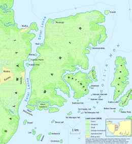
235:. It has an area of 42.8 square kilometres (16.5 sq mi), its length north to south is about 9 kilometres (5.6 mi), and its east-west extent varies between 2.5 kilometres (1.6 mi) and 6 kilometres (3.7 mi). It is relatively low-lying, with no point exceeding an elevation of 80 metres (260 ft). Its interior is forested, with
75:
45:
284:
is located facing Warir across the strait. The small islands of Waif, Motop, Kalobo Peleh and Kalobo Wei are located in the Lenna Strait. At the south shore of Warir, narrow creeks separate it from the three smaller islands of Warir
Manyanyim (with an area of
254:
villages of
Salawati. For about a year during World War II, the island was inhabited by the people of Samate who had fled the Japanese occupation of their village. After the establishment of Indonesian rule since the 1960s, immigrant
316:
km). Batimee in turn is surrounded by the tiny islands of
Batimee Lil, Sobrain Maralol, Sobrain Sawi, and Batimee Ket. Further up north along the coast of Warir can be found the tiny island of Wamasinketo. The island of
37:
67:
442:
437:
390:
432:
280:, width ranging between 0.5 and 1.1 km), which separates it from the mainland of Salawati, where the village of
368:
117:
381:
Van der Leeden, Lex (1995). "World War II in Samate". In Connie Baak; Mary Bakker; Dick van der Maij (eds.).
220:
385:. Department of Languages and Cultures of South-East Asia and Oceania, Leiden University. p. 383.
337:
199:
281:
251:
228:
204:
105:
386:
239:
fringing the coastal areas, and some agricultural land in the north. The small settlement of
247:
224:
192:
246:
Warir has long been used for cultivation, and it has been important for the people of
426:
406:
367:). For the names of the islands, see the various sources used in the description of
256:
23:
336:
A few kilometres to the south-east across the strait of
Sangoilin Mon lie the
262:
The waters around Warir fall within the
Dampier Strait Marine Protected Area.
364:
132:
119:
236:
180:
232:
300:
To the south-east, similar narrow creeks separate the islands of
359:
The numerical data and land cover information is from the
383:
Tales from a
Concave World: Liber Amicorum Bert Voorhoeve
231:, it lies off the eastern coast of the larger island of
198:
188:
172:
164:
156:
148:
111:
101:
96:
407:"Kawasan Konservasi Perairan Kepulauan Raja Ampat"
275:
333:km), lies off the northeastern tip of Warir.
8:
270:To the west of Warir is the narrow and long
16:
293:km), an unnamed island with an area of 0.45
22:
15:
355:
353:
349:
243:is situated on the north-west coast.
7:
152:42.8 km (16.5 sq mi)
14:
73:
66:
43:
36:
87:Show map of Raja Ampat Islands
1:
443:Islands of Western New Guinea
227:, Indonesia. Situated in the
74:
44:
438:Landforms of Southwest Papua
259:have settled on the island.
168:48.3 km (30.01 mi)
57:Show map of Southwest Papua
459:
369:File:Warir Island map.svg
177:
30:
21:
289:km), Warir Takektol (0.8
363:dataset (available at
276:
221:Raja Ampat Archipelago
219:, is an island in the
160:10 km (6 mi)
361:Penutupan Lahan 2011
129: /
18:
433:Raja Ampat Islands
210:
209:
450:
417:
416:
414:
413:
403:
397:
396:
378:
372:
365:WebGIS Kehutanan
357:
332:
321:, also known as
315:
307:
296:
292:
288:
279:
144:
143:
141:
140:
139:
134:
130:
127:
126:
125:
122:
88:
77:
76:
70:
58:
47:
46:
40:
26:
19:
458:
457:
453:
452:
451:
449:
448:
447:
423:
422:
421:
420:
411:
409:
405:
404:
400:
393:
380:
379:
375:
358:
351:
346:
330:
313:
305:
294:
290:
286:
268:
225:Southwest Papua
193:Southwest Papua
184:
137:
135:
133:1.03°S 131.12°E
131:
128:
123:
120:
118:
116:
115:
92:
91:
90:
89:
86:
85:
84:
83:
82:
78:
61:
60:
59:
56:
55:
54:
53:
52:
48:
12:
11:
5:
456:
454:
446:
445:
440:
435:
425:
424:
419:
418:
398:
391:
373:
348:
347:
345:
342:
267:
264:
208:
207:
202:
196:
195:
190:
186:
185:
178:
175:
174:
173:Administration
170:
169:
166:
162:
161:
158:
154:
153:
150:
146:
145:
113:
109:
108:
103:
99:
98:
94:
93:
80:
79:
72:
71:
65:
64:
63:
62:
50:
49:
42:
41:
35:
34:
33:
32:
31:
28:
27:
13:
10:
9:
6:
4:
3:
2:
455:
444:
441:
439:
436:
434:
431:
430:
428:
408:
402:
399:
394:
388:
384:
377:
374:
370:
366:
362:
356:
354:
350:
343:
341:
339:
338:Kabra Islands
334:
328:
324:
320:
311:
303:
298:
283:
278:
273:
265:
263:
260:
258:
253:
249:
244:
242:
238:
234:
230:
226:
222:
218:
214:
206:
203:
201:
197:
194:
191:
187:
183:
182:
176:
171:
167:
163:
159:
155:
151:
147:
142:
138:-1.03; 131.12
114:
110:
107:
104:
100:
95:
69:
39:
29:
25:
20:
410:. Retrieved
401:
382:
376:
360:
335:
326:
322:
318:
309:
301:
299:
272:Lenna Strait
271:
269:
266:Surroundings
261:
257:Bugis people
245:
240:
216:
212:
211:
179:
277:Selat Lenna
229:Sele Strait
136: /
112:Coordinates
106:Sele Strait
427:Categories
412:2020-01-02
392:9073006066
344:References
205:Raja Ampat
327:Kasimraja
237:mangroves
181:Indonesia
165:Coastline
97:Geography
308:km) and
233:Salawati
189:Province
124:131°07′E
102:Location
302:Batimee
200:Regency
389:
331:
323:Kasiem
314:
310:Winkle
306:
295:
291:
287:
282:Kalobo
252:Kalobo
248:Samate
241:Wamega
157:Length
121:1°02′S
329:(0.17
319:Kasim
217:Waiji
215:, or
213:Warir
81:Warir
51:Warir
17:Warir
387:ISBN
312:(0.8
304:(4.6
297:km.
250:and
149:Area
325:or
285:0.3
223:of
429::
352:^
340:.
415:.
395:.
371:.
274:(
Text is available under the Creative Commons Attribution-ShareAlike License. Additional terms may apply.