2165:
666:, also with an average temperature of 11 °C Wood End has a higher average temperature than most of England. The boundaries of Wood End are diamond-shaped, with the northern point at Edge Hill and the southern point at Glenville Avenue. To the northwest is Edge Hill Wood, to the north east are the fields of Delves Farm, and to the south is Poplars Farm. Wood End is 28 hectares (69.2 acres) in area. The original boundaries ran along Johnson Road and the ends of Smith Street and Wood Street, and enclosed 5.3 hectares (13.1 acres).
61:
1108:
578:
570:
42:
401:
1100:
1089:
1850:
1867:
1842:
1825:
531:, was opened in 1911. The original school building no longer exists. In 1995 the school was expanded. On 13 August 1998 the older part of the school burnt down, but it has since been rebuilt. During the village's expansion over the years, parts of the village, such as Glenville Avenue (laid out during the 1950s), steadily ate into the surrounding woodland.
68:
283:
526:
was later built in the 1960s. Also added to the housing stock was
Glenville Avenue and Delves Crescent, which were council housing. In the late 1970s Birchfield Close was constructed for private housing, and the village was expanded in 1985 when a new estate, Pinewood Avenue, was built to the west. A
495:
The land on which the village was built consisted of fields belonging to two farms, Delves Farm and
Poplars Farm, both of which exist today. There were two woods, Edge Hill Wood and Smith's Wood, but only the former survives today. There was also a small settlement of several houses called Edge
630:. Mining tracks used to run through Kingsbury Wood, of which there is still evidence. A small stream arises (Penmire Brook) in Wood End, next to Glenville Avenue, and flows through the centre of the oldest part of the wood into Kingsbury village and eventually outflows into the
2216:
2103:
2092:
2205:
2081:
2318:
2285:
1285:. In May 2011 there were 9 reports of criminal activity. In June 2011 there were 12 reports. In July 2011 there were 25 reported crimes in the village with 10 reports of anti-social behaviour and 9 reports of burglary. Wood End is part of the North
1352:
of Hurley and Wood End in 2001, of 3,642 inhabitants 2,409 described their health as good, 914 described their health as fairly good and 319 described their health as poor. In the ward there were 215 Disability living allowance claimants in 2009.
1938:
1927:
1260:
and Wood End out of 2,629 people 1,791 describe themselves as
Economically active and 838 describe themselves as Economically inactive and 274 are retired with the most common number of hours worked per week 38 to 48 hours.
597:
was 3,642. Over 99.5% of people (3,550) describe themselves as White
British with only 89 people from other ethnic groups. The modal distance travelled to work is 5–10 kilometres (3.1–6.2 mi), essentially to
2737:
2117:
467:
The official name of the village is Wood End, from its founding in 1890, although it is sometimes written as
Woodend. The name is derived from the village's position at the end of the nearby
323:
1916:
130:
187:
2732:
2352:
2241:
1220:
Co-operative
Society, a garage on Tamworth Road, and a hairdressers in Wood Street. Just outside the village there is a factory owned by the Swedish flooring manufacturer
2143:
2132:
2044:
1525:
in Edge Hill, in existence before the village was built. It was closed some time in the late 1970s, and later demolished. The site is now occupied by a private house.
1193:
307:
1171:
331:
2341:
1776:
534:
Much of the village dates from the 1980s, with the old housing being demolished and replaced. The older housing stock remains on one side of Wood Street, on the
367:
1460:
1092:
516:
2757:
1506:. St Michael & All Angels is a small wooden church on Smith Street, built in 1906. Today it is the only place of worship in the village, part of the
2179:
1281:
was 5 crimes per 1,000 people. In 2010 the figure for Hurley and Wood End had decreased to 3 crimes per 1,000 people. The most common type of crime is
538:
side of
Tamworth road (at the top of Wood Street), on Johnson Street, and on part of Smith Street. The most recent addition to the residential area is
2114:
1549:
and Wood End, 1,068 adults had no educational qualifications and 1,560 adults had level 1 or higher qualifications. The village does not have its own
1480:
2752:
2706:
2747:
2717:
2270:
1562:
269:
471:
Wood, a pine plantation. Parts of the village are still known as Edge Hill. To avoid confusion with other Wood Ends the name of the nearby town,
2558:
2416:
1744:
1728:
585:
The population, in 2001, for the 002D (Lower Layer Super Output Area), in which Wood End is the only settlement, was 2,205. According to the
1436:
627:
300:
60:
546:. One of the oldest houses from before it became Wood End, Edge Hill House, was demolished in 2019 for new homes, stood next to where the
623:
295:
1672:. The village has 4 bus stops along Tamworth Road, which are served by buses running on routes 777, 767, 115, 118 and 119. The nearest
1769:
1636:
was established with the route including a north-eastern part of Wood End (through its fields). The nearest leisure facilities are in
1472:
2154:
2793:
2727:
1622:
1519:
602:, with the most common form of employment being manufacturing. The village has 1,820 female inhabitants and 1,822 male inhabitants.
2798:
349:
2238:
1529:
is nearer to Wood End than it is to the village of
Baxterley. It is also part of the Kingsbury and Baxterley Group of churches.
2762:
2742:
2722:
1440:
312:
257:
223:
2029:
2702:
2426:
2375:
2363:
1637:
1570:
1554:
359:
1724:
511:
opened in 1905, and still remains open in the original building. Wood End became a village in 1906 with the opening of the
2788:
1762:
1381:
123:
2767:
2585:
1685:
1167:
2610:
2462:
2409:
1538:
1452:
1174:
452:
104:
2676:
2645:
2635:
2600:
1677:
1143:
1139:
1127:
631:
354:
2590:
1880:
1578:
1229:
1155:
237:
1985:
1166:
is an old mining community it is considered a Labour safe seat. Wood End is covered by the
Kingsbury Ward in
2712:
2500:
2176:
1997:
1876:
1801:
1665:
1507:
1503:
1424:
1309:
1290:
1233:
1217:
1182:
1135:
1131:
1116:
655:
615:
599:
468:
456:
420:
47:
1412:
1385:
1209:
611:
543:
440:
213:
1252:, with manufacturing being the most common type of employment, followed by wholesale and retail. For the
2452:
2402:
1689:
1321:
1282:
146:
2267:
1754:
1594:
1107:
508:
444:
2070:
2059:
2697:
1885:
1732:
1649:
1546:
1495:
1476:
1333:
1317:
1313:
1270:
1257:
1178:
590:
480:
169:
1514:
group of churches along with
Kingsbury, Baxterley, Merevale and Hurley, all of which share the same
2540:
2525:
1432:
1197:
619:
288:
2447:
2033:
1709:
1626:
1369:
1362:
1341:
1306:
1278:
1151:
504:
476:
428:
416:
205:
177:
113:
2307:
577:
2681:
2666:
2530:
1740:
1558:
1499:
1159:
1123:
535:
610:
The village is 110 metres (360 ft) above sea level and is situated on a small hill. The
2625:
2467:
2457:
1834:
1550:
1526:
1397:
1389:
1373:
1345:
262:
2256:
503:, which closed in the late 1970s. The first houses were built in 1890 to house workers for
2505:
2274:
2245:
2227:
2183:
2121:
1705:
1673:
1629:
1404:
1213:
651:
554:
2018:
634:. At the lower end of Tamworth Road, a freight line that previously serving the mines at
2661:
2520:
1974:
1614:
1574:
1542:
1488:
1349:
1312:
trust area. The village does not have its own doctor's surgery or pharmacy The nearest
1253:
1163:
594:
586:
528:
436:
569:
41:
2782:
1720:
1645:
1633:
1610:
1597:
on Tamworth Road which was opened in 1905. It was used by miners, farm labourers and
1464:
1237:
1225:
1003:
512:
424:
2394:
1240:. Until 1968 the majority of employed people living in the village worked in nearby
400:
17:
2671:
2595:
2432:
2177:
NHS - Find your Nearest Doctor, Optician, Pharmacy, dentist, hospital: Outline NWBC
2048:
1661:
1602:
1590:
1428:
1337:
1286:
1244:. Today the majority of those in employment work in Tamworth, with some working in
1185:
1119:
1099:
659:
558:
523:
448:
195:
153:
81:
1577:
on Wood Street, which is also used for children from surrounding villages such as
2640:
2580:
1736:
1606:
1408:
412:
2389:
2630:
2615:
2605:
2575:
2510:
2490:
1856:
1810:
1713:
1416:
1294:
1245:
1241:
1147:
1088:
542:
View, completed in 2005, which was built on scrub land previously occupied by
484:
472:
382:
369:
2620:
2296:
1890:
1701:
1618:
1511:
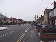
1456:
639:
547:
497:
247:
2550:
2515:
2495:
2485:
1805:
1641:
1609:, with the nearest one being in the village of Hockley. There is a large
1601:
workers, and helped to support the Wood End Silver Band. There is also a
1566:
1484:
1468:
1400:
1329:
1325:
1249:
432:
1950:
2545:
2535:
1796:
1681:
1420:
1393:
1365:
1274:
1269:
In 2009 the crime rate was 3.6 crimes per 1,000 people for the ward of
663:
229:
2330:
1814:
1669:
1522:
1491:
1377:
1189:
642:
now serves the rail freight terminal st Birch Coppice Business Park.
635:
550:
539:
500:
140:
1158:, which is represented (2011) by Ann Lewis and Hayden Philips, both
1605:
dating from the 1960s. The village does not have any takeaways or
1515:
1221:
1106:
1098:
1087:
618:
Wood, which is semi-ancient woodland in parts, part of the former
576:
568:
399:
1598:
2398:
1758:
1170:
and is represented by the Labour Brian Moss. It is part of the
1717:
2353:
Wood End (nr Kingsbury), Smith Street, Adj (On Tamworth Road)
1138:
Rural District was abolished and Wood End became part of the
658:
7 miles (11.3 km) away, With a rainfall of 764 mm
1273:
and Wood End. During the same period the crime rate for the
1150:
Rural District became part of the newly formed district of
2194:
1122:. When the village was built in 1890 it was part of the
479:
is sometimes used, but rarely, to avoid confusion with
2376:
Nearest airport to CV9 2RS (Pinewood Avenue, Wood End)
2364:
Wood End (Nr Kingsbury), Warwickshire Nearest station
1785:
Places adjacent to Wood End, Kingsbury, Warwickshire
451:. The population of Wood End is 2,205, but from the
2690:
2654:
2568:
2476:
2440:
1928:
Key Figures for 2001 Census: Census Area Statistics
1368:Council. Water and sewage services are provided by
322:
306:
294:
282:
268:
256:
246:
236:
222:
204:
186:
168:
152:
138:
122:
111:
99:
91:
34:
1727:. Local commercial stations in the area include
2319:Area: Hurley and Wood End (Ward) Qualifications
1998:"Average Conditions Birmingham, United Kingdom"
1743:TV regions which are broadcast from the nearby
614:underlies the village. Adjacent to Wood End is
2410:
1770:
1396:. Unlike most villages in the area it uses a
1336:. Out of hours GP services are also based at
8:
1467:, many of the residents attend other nearby
1459:, 19% Non-Religious and 1% Other. Although
1289:West Neighbourhood Policing Team, based in
2417:
2403:
2395:
1777:
1763:
1755:
1660:Wood End lies close to junction 10 of the
1621:at the end of Smith Street. As of 2009, a
1361:Waste collection services are provided by
669:
622:. Kingsbury Wood has been designated as a
46:Tamworth Road in Wood End looking towards
31:
2297:Kingsbury and Baxterley group of churches
2115:Crime Statistics For Hurley And Wood End
2030:Councillors by Ward: Hurley and Wood End
1427:01827 area code. The nearest police and
1423:is located in Dordon. Wood End uses the
435:village to Tamworth. It has a church, a
419:, England. It lies to the south east of
1909:
1563:North Warwickshire and Hinckley College
1431:are in Atherstone. Wood End is part of
321:
277:
245:
221:
137:
121:
90:
38:
2559:List of civil parishes in Warwickshire
1729:Hits Radio Coventry & Warwickshire
1648:in the Tamworth & District Sunday
553:was. The site can be seen on the 1884
2308:St Michael & All Angels, Wood End
2217:Disability Living Allowance Claimants
1745:Sutton Coldfield transmitting station
1455:the population of the village is 80%
1130:, it became part of the newly formed
305:
293:
281:
267:
255:
235:
203:
185:
167:
110:
7:
1792:
1437:Warwickshire Fire and Rescue Service
1297:, which has 7 officers and 3 PCSOs.
404:Tamworth Road Looking Towards Hurley
1708:, which has a separate edition for
624:Site of Special Scientific Interest
95:0.28 km (0.11 sq mi)
2390:Information from Kingsbury Council
1589:The village does not have its own
1461:St Michael & All Angels Church
1093:St Michael & All Angels Church
517:St Michael & All Angels Church
25:
2019:Wood End Kingsbury Parish Council
1334:Accident and Emergency Department
1111:The Playing Field on Smith Street
1865:
1848:
1840:
1823:
1735:. The village is covered by the
1124:Tamworth Rural Sanitary District
662:is one of the drier counties of
67:
66:
59:
40:
1725:BBC Coventry & Warwickshire
1652:League called Wood End Sports.
1518:. Previously there was a small
1502:being St. John's Presbytery in
1481:St. Mary The Church of Our Lady
1441:West Midlands Ambulance Service
1571:Tamworth and Lichfield College
561:along with just a few others.
145:98 mi (158 km)
1:
2228:Dordon Sewage Treatment Works
1866:
1824:
1382:distribution network operator
1316:'s surgeries can be found in
475:is added. The name Wood End,
423:and close to the border with
2733:Parliamentary constituencies
2268:Warwickshire Police Stations
1849:
1841:
673:Climate data for Birmingham
581:Kingsbury Link Business Park
427:. It grew around the former
118:7,875/km (20,400/sq mi)
2166:NHS Surgeries Near Wood End
2049:Warwickshire County Council
1561:in the area is provided by
1487:. Wood End lies within the
1192:in 2020 it was part of the
1168:Warwickshire County Council
1115:The village is part of the
862:Mean daily minimum °C (°F)
792:Mean daily maximum °C (°F)
124:OS grid reference
29:Human settlement in England
2815:
2758:Grade II* listed buildings
2082:Distance Travelled to Work
2060:Wood End Convenience Store
1986:England 1971–2000 averages
1917:Information On School Fire
1704:covering the area are the
1664:, and is 2 miles from the
1553:, so most students attend
1473:Church of the Resurrection
1175:parliamentary constituency
1154:. Wood End is part of the
1075:
672:
507:, which opened in 1897. A
2182:28 September 2011 at the
2045:Brian Moss Kingsbury ward
1790:
1407:postcode. There is a sub-
1144:Local Government Act 1972
1140:Atherstone Rural District
1128:Local Government Act 1894
1001:
931:
861:
791:
721:
716:
713:
710:
707:
704:
701:
698:
695:
692:
689:
686:
683:
680:
677:
340:
318:
278:
54:
39:
2794:Villages in Warwickshire
2753:Grade I listed buildings
2286:Neighbourhood Statistics
2144:June 2011 Wood End Crime
1644:in Tamworth. There is a
1305:The village lies in the
1156:Hurley and Wood End Ward
496:Hill, and a United Free
2799:Kingsbury, Warwickshire
2331:Wood End Primary School
1228:. Between Wood End and
1132:Tamworth Rural District
1103:Wood End Primary School
431:but now it serves as a
2273:11 August 2003 at the
2239:Warwickshire Libraries
2195:George Elliot Hospital
2133:May crime for Wood End
1939:2001 census statistics
1585:Culture and recreation
1374:Sewage Treatment Works
1293:, with the station in
1112:
1104:
1096:
612:Warwickshire Coalfield
589:the population of the
582:
574:
557:County Series map for
405:
258:Postcode district
2453:Nuneaton and Bedworth
2441:Boroughs or districts
2244:25 April 2010 at the
1723:covering the area is
1471:churches such as the
1415:. The Postal Town is
1322:George Eliot Hospital
1283:anti-social behaviour
1126:. In 1894, under the
1110:
1102:
1091:
626:. It is owned by the
580:
573:Wood End Village Hall
572:
455:has been included in
403:
2789:Wood End, Atherstone
2521:Royal Leamington Spa
2120:21 July 2011 at the
1733:Capital Mid-Counties
1716:Recorder. The local
1688:(17 miles) and
1496:St. John the Baptist
1328:is the area's local
1216:that is part of the
1142:. In 1974 under the
1076:Source: BBC Weather
722:Record high °C (°F)
238:Sovereign state
18:Wood End, Atherstone
2677:Stratford-upon-Avon
2541:Stratford-upon-Avon
2479:(cities in italics)
1666:A5 (Watling Street)
1433:Warwickshire Police
1411:located inside the
1198:European Parliament
932:Record low °C (°F)
628:Ministry of Defence
379: /
2448:North Warwickshire
2155:Crime for Wood End
1955:birchcoppice.co.uk
1710:North Warwickshire
1627:North Warwickshire
1595:working men's club
1370:Severn Trent Water
1363:North Warwickshire
1342:Good Hope Hospital
1307:North Warwickshire
1279:North Warwickshire
1210:Co-operative store
1172:North Warwickshire
1152:North Warwickshire
1113:
1105:
1097:
654:is in the town of
583:
575:
509:working men's club
505:Kingsbury Colliery
477:North Warwickshire
445:working men's club
441:co-operative store
429:Kingsbury Colliery
417:North Warwickshire
406:
332:North Warwickshire
324:UK Parliament
270:Dialling code
178:North Warwickshire
2776:
2775:
2682:Warwickshire ring
2531:Shipston-on-Stour
2477:Major settlements
2463:Stratford-on-Avon
2427:Ceremonial county
2093:Economic Activity
1901:
1900:
1896:
1895:
1741:BBC West Midlands
1692:(25 miles).
1593:, but there is a
1559:Further education
1537:According to the
1500:collegiate church
1451:According to the
1080:
1079:
536:Working Mens Club
527:school, Wood End
398:
397:
188:Shire county
16:(Redirected from
2806:
2763:Lord Lieutenants
2435:
2429:
2419:
2412:
2405:
2396:
2378:
2373:
2367:
2361:
2355:
2350:
2344:
2339:
2333:
2328:
2322:
2316:
2310:
2305:
2299:
2294:
2288:
2283:
2277:
2265:
2259:
2254:
2248:
2236:
2230:
2225:
2219:
2214:
2208:
2203:
2197:
2192:
2186:
2174:
2168:
2163:
2157:
2152:
2146:
2141:
2135:
2130:
2124:
2112:
2106:
2101:
2095:
2090:
2084:
2079:
2073:
2071:Pergo Contact Us
2068:
2062:
2057:
2051:
2042:
2036:
2027:
2021:
2016:
2010:
2009:
2007:
2005:
1994:
1988:
1983:
1977:
1972:
1966:
1965:
1963:
1961:
1947:
1941:
1936:
1930:
1925:
1919:
1914:
1869:
1868:
1852:
1851:
1844:
1843:
1835:Sutton Coldfield
1827:
1826:
1793:
1779:
1772:
1765:
1756:
1638:Kingsbury School
1555:Kingsbury School
1551:secondary school
1527:Baxterley Church
1520:United Methodist
1498:, with the main
1392:better known as
1390:Central Networks
1346:Sutton Coldfield
1340:. There is also
1177:and the current
670:
394:
393:
391:
390:
389:
384:
383:52.582°N 1.643°W
380:
377:
376:
375:
372:
346:
232:
134:
133:
80:Location within
70:
69:
63:
44:
32:
21:
2814:
2813:
2809:
2808:
2807:
2805:
2804:
2803:
2779:
2778:
2777:
2772:
2718:Monastic houses
2686:
2650:
2564:
2553:
2506:Henley-in-Arden
2478:
2472:
2436:
2431:
2425:
2423:
2386:
2381:
2374:
2370:
2362:
2358:
2351:
2347:
2342:Wood End Sports
2340:
2336:
2329:
2325:
2317:
2313:
2306:
2302:
2295:
2291:
2284:
2280:
2275:Wayback Machine
2266:
2262:
2255:
2251:
2246:Wayback Machine
2237:
2233:
2226:
2222:
2215:
2211:
2204:
2200:
2193:
2189:
2184:Wayback Machine
2175:
2171:
2164:
2160:
2153:
2149:
2142:
2138:
2131:
2127:
2122:Wayback Machine
2113:
2109:
2102:
2098:
2091:
2087:
2080:
2076:
2069:
2065:
2058:
2054:
2043:
2039:
2028:
2024:
2017:
2013:
2003:
2001:
1996:
1995:
1991:
1984:
1980:
1975:Weather for CV9
1973:
1969:
1959:
1957:
1951:"Birch Coppice"
1949:
1948:
1944:
1937:
1933:
1926:
1922:
1915:
1911:
1907:
1902:
1897:
1853:
1786:
1783:
1753:
1706:Tamworth Herald
1698:
1674:railway station
1658:
1630:Forest of Arden
1587:
1535:
1449:
1359:
1357:Public services
1303:
1267:
1224:. and Planters
1206:
1095:on Smith Street
1086:
1081:
1070:
1065:
1060:
1055:
1050:
1045:
1040:
1035:
1030:
1025:
1020:
1015:
1010:
996:
991:
986:
981:
976:
971:
966:
961:
956:
951:
946:
941:
936:
926:
921:
916:
911:
906:
901:
896:
891:
886:
881:
876:
871:
866:
856:
851:
846:
841:
836:
831:
826:
821:
816:
811:
806:
801:
796:
786:
781:
776:
771:
766:
761:
756:
751:
746:
741:
736:
731:
726:
652:weather station
648:
620:Forest of Arden
608:
567:
555:Ordnance Survey
493:
465:
387:
385:
381:
378:
373:
370:
368:
366:
365:
364:
344:
336:
228:
218:
200:
182:
164:
129:
128:
87:
86:
85:
84:
78:
77:
76:
75:
71:
50:
30:
23:
22:
15:
12:
11:
5:
2812:
2810:
2802:
2801:
2796:
2791:
2781:
2780:
2774:
2773:
2771:
2770:
2765:
2760:
2755:
2750:
2748:Country Houses
2745:
2740:
2735:
2730:
2725:
2720:
2715:
2710:
2700:
2694:
2692:
2688:
2687:
2685:
2684:
2679:
2674:
2669:
2664:
2658:
2656:
2652:
2651:
2649:
2648:
2643:
2638:
2633:
2628:
2623:
2618:
2613:
2608:
2603:
2598:
2593:
2588:
2583:
2578:
2572:
2570:
2566:
2565:
2563:
2562:
2548:
2543:
2538:
2533:
2528:
2523:
2518:
2513:
2508:
2503:
2498:
2493:
2488:
2482:
2480:
2474:
2473:
2471:
2470:
2465:
2460:
2455:
2450:
2444:
2442:
2438:
2437:
2424:
2422:
2421:
2414:
2407:
2399:
2393:
2392:
2385:
2384:External links
2382:
2380:
2379:
2368:
2356:
2345:
2334:
2323:
2311:
2300:
2289:
2278:
2260:
2257:01827 Tamworth
2249:
2231:
2220:
2209:
2206:General Health
2198:
2187:
2169:
2158:
2147:
2136:
2125:
2107:
2096:
2085:
2074:
2063:
2052:
2037:
2022:
2011:
1989:
1978:
1967:
1942:
1931:
1920:
1908:
1906:
1903:
1899:
1898:
1894:
1893:
1888:
1883:
1873:
1872:
1870:
1863:
1860:
1859:
1854:
1839:
1837:
1831:
1830:
1828:
1821:
1818:
1817:
1808:
1799:
1791:
1788:
1787:
1784:
1782:
1781:
1774:
1767:
1759:
1752:
1749:
1697:
1694:
1680:. The nearest
1657:
1654:
1615:football pitch
1586:
1583:
1575:primary school
1534:
1531:
1489:Roman Catholic
1448:
1445:
1419:. The nearest
1405:Birmingham (B)
1403:rather than a
1358:
1355:
1302:
1299:
1266:
1263:
1205:
1202:
1134:. In 1965 the
1085:
1082:
1078:
1077:
1073:
1072:
1067:
1062:
1057:
1052:
1047:
1042:
1037:
1032:
1027:
1022:
1017:
1012:
1007:
999:
998:
993:
988:
983:
978:
973:
968:
963:
958:
953:
948:
943:
938:
933:
929:
928:
923:
918:
913:
908:
903:
898:
893:
888:
883:
878:
873:
868:
863:
859:
858:
853:
848:
843:
838:
833:
828:
823:
818:
813:
808:
803:
798:
793:
789:
788:
783:
778:
773:
768:
763:
758:
753:
748:
743:
738:
733:
728:
723:
719:
718:
715:
712:
709:
706:
703:
700:
697:
694:
691:
688:
685:
682:
679:
675:
674:
668:
647:
644:
607:
604:
566:
563:
529:Primary School
492:
489:
464:
461:
437:primary school
396:
395:
388:52.582; -1.643
363:
362:
357:
352:
347:
345:List of places
341:
338:
337:
335:
334:
328:
326:
320:
319:
316:
315:
310:
304:
303:
298:
292:
291:
286:
280:
279:
276:
275:
272:
266:
265:
260:
254:
253:
250:
244:
243:
242:United Kingdom
240:
234:
233:
226:
220:
219:
217:
216:
210:
208:
202:
201:
199:
198:
192:
190:
184:
183:
181:
180:
174:
172:
166:
165:
163:
162:
158:
156:
150:
149:
143:
136:
135:
126:
120:
119:
116:
109:
108:
101:
97:
96:
93:
89:
88:
79:
73:
72:
65:
64:
58:
57:
56:
55:
52:
51:
45:
37:
36:
28:
24:
14:
13:
10:
9:
6:
4:
3:
2:
2811:
2800:
2797:
2795:
2792:
2790:
2787:
2786:
2784:
2769:
2768:High Sheriffs
2766:
2764:
2761:
2759:
2756:
2754:
2751:
2749:
2746:
2744:
2741:
2739:
2736:
2734:
2731:
2729:
2726:
2724:
2721:
2719:
2716:
2714:
2711:
2708:
2707:by population
2704:
2701:
2699:
2696:
2695:
2693:
2689:
2683:
2680:
2678:
2675:
2673:
2670:
2668:
2665:
2663:
2660:
2659:
2657:
2653:
2647:
2644:
2642:
2639:
2637:
2634:
2632:
2629:
2627:
2624:
2622:
2619:
2617:
2614:
2612:
2609:
2607:
2604:
2602:
2599:
2597:
2594:
2592:
2589:
2587:
2584:
2582:
2579:
2577:
2574:
2573:
2571:
2567:
2561:
2560:
2556:
2552:
2549:
2547:
2544:
2542:
2539:
2537:
2534:
2532:
2529:
2527:
2524:
2522:
2519:
2517:
2514:
2512:
2509:
2507:
2504:
2502:
2499:
2497:
2494:
2492:
2489:
2487:
2484:
2483:
2481:
2475:
2469:
2466:
2464:
2461:
2459:
2456:
2454:
2451:
2449:
2446:
2445:
2443:
2439:
2434:
2428:
2420:
2415:
2413:
2408:
2406:
2401:
2400:
2397:
2391:
2388:
2387:
2383:
2377:
2372:
2369:
2365:
2360:
2357:
2354:
2349:
2346:
2343:
2338:
2335:
2332:
2327:
2324:
2320:
2315:
2312:
2309:
2304:
2301:
2298:
2293:
2290:
2287:
2282:
2279:
2276:
2272:
2269:
2264:
2261:
2258:
2253:
2250:
2247:
2243:
2240:
2235:
2232:
2229:
2224:
2221:
2218:
2213:
2210:
2207:
2202:
2199:
2196:
2191:
2188:
2185:
2181:
2178:
2173:
2170:
2167:
2162:
2159:
2156:
2151:
2148:
2145:
2140:
2137:
2134:
2129:
2126:
2123:
2119:
2116:
2111:
2108:
2105:
2100:
2097:
2094:
2089:
2086:
2083:
2078:
2075:
2072:
2067:
2064:
2061:
2056:
2053:
2050:
2046:
2041:
2038:
2035:
2031:
2026:
2023:
2020:
2015:
2012:
2000:. BBC Weather
1999:
1993:
1990:
1987:
1982:
1979:
1976:
1971:
1968:
1956:
1952:
1946:
1943:
1940:
1935:
1932:
1929:
1924:
1921:
1918:
1913:
1910:
1904:
1892:
1889:
1887:
1884:
1882:
1878:
1875:
1874:
1871:
1864:
1862:
1861:
1858:
1855:
1847:
1838:
1836:
1833:
1832:
1829:
1822:
1820:
1819:
1816:
1812:
1809:
1807:
1803:
1800:
1798:
1795:
1794:
1789:
1780:
1775:
1773:
1768:
1766:
1761:
1760:
1757:
1750:
1748:
1746:
1742:
1738:
1734:
1730:
1726:
1722:
1721:radio station
1719:
1715:
1711:
1707:
1703:
1695:
1693:
1691:
1690:East Midlands
1687:
1683:
1679:
1675:
1671:
1667:
1663:
1655:
1653:
1651:
1647:
1646:football club
1643:
1639:
1635:
1634:walking trail
1631:
1628:
1624:
1620:
1616:
1612:
1611:playing field
1608:
1604:
1600:
1596:
1592:
1584:
1582:
1580:
1576:
1573:. There is a
1572:
1568:
1564:
1560:
1556:
1552:
1548:
1544:
1540:
1532:
1530:
1528:
1524:
1521:
1517:
1513:
1509:
1505:
1501:
1497:
1493:
1490:
1486:
1482:
1478:
1474:
1470:
1466:
1465:parish church
1462:
1458:
1454:
1446:
1444:
1442:
1438:
1434:
1430:
1429:fire stations
1426:
1422:
1418:
1414:
1410:
1406:
1402:
1399:
1398:Coventry (CV)
1395:
1391:
1387:
1383:
1379:
1375:
1371:
1367:
1364:
1356:
1354:
1351:
1347:
1343:
1339:
1335:
1331:
1327:
1323:
1319:
1315:
1311:
1308:
1300:
1298:
1296:
1292:
1288:
1284:
1280:
1276:
1272:
1264:
1262:
1259:
1255:
1251:
1247:
1243:
1239:
1238:Business Park
1235:
1231:
1227:
1226:garden centre
1223:
1219:
1215:
1211:
1203:
1201:
1199:
1195:
1194:West Midlands
1191:
1187:
1184:
1180:
1176:
1173:
1169:
1165:
1161:
1157:
1153:
1149:
1145:
1141:
1137:
1133:
1129:
1125:
1121:
1118:
1109:
1101:
1094:
1090:
1083:
1074:
1068:
1063:
1058:
1053:
1048:
1043:
1038:
1033:
1028:
1023:
1018:
1013:
1008:
1005:
1004:precipitation
1000:
994:
989:
984:
979:
974:
969:
964:
959:
954:
949:
944:
939:
934:
930:
924:
919:
914:
909:
904:
899:
894:
889:
884:
879:
874:
869:
864:
860:
854:
849:
844:
839:
834:
829:
824:
819:
814:
809:
804:
799:
794:
790:
784:
779:
774:
769:
764:
759:
754:
749:
744:
739:
734:
729:
724:
720:
676:
671:
667:
665:
661:
657:
653:
645:
643:
641:
637:
633:
629:
625:
621:
617:
613:
605:
603:
601:
596:
593:and Wood End
592:
588:
579:
571:
564:
562:
560:
556:
552:
549:
545:
541:
537:
532:
530:
525:
520:
518:
514:
513:parish church
510:
506:
502:
499:
490:
488:
486:
482:
478:
474:
470:
462:
460:
458:
454:
450:
446:
442:
438:
434:
430:
426:
425:Staffordshire
422:
418:
414:
410:
402:
392:
361:
358:
356:
353:
351:
348:
343:
342:
339:
333:
330:
329:
327:
325:
317:
314:
313:West Midlands
311:
309:
302:
299:
297:
290:
287:
285:
273:
271:
264:
261:
259:
251:
249:
241:
239:
231:
227:
225:
215:
214:West Midlands
212:
211:
209:
207:
197:
194:
193:
191:
189:
179:
176:
175:
173:
171:
160:
159:
157:
155:
151:
148:
144:
142:
132:
127:
125:
117:
115:
106:
102:
98:
94:
83:
62:
53:
49:
43:
33:
27:
19:
2557:
2554:
2433:Warwickshire
2371:
2359:
2348:
2337:
2326:
2314:
2303:
2292:
2281:
2263:
2252:
2234:
2223:
2212:
2201:
2190:
2172:
2161:
2150:
2139:
2128:
2110:
2104:Hours Worked
2099:
2088:
2077:
2066:
2055:
2040:
2025:
2014:
2002:. Retrieved
1992:
1981:
1970:
1958:. Retrieved
1954:
1945:
1934:
1923:
1912:
1845:
1699:
1659:
1603:village hall
1591:public house
1588:
1536:
1450:
1360:
1338:George Eliot
1332:. It has an
1304:
1287:Warwickshire
1268:
1207:
1186:Craig Tracey
1183:Conservative
1120:civil parish
1114:
1006:mm (inches)
660:Warwickshire
650:The nearest
649:
609:
584:
565:Demographics
559:Warwickshire
533:
524:village hall
521:
494:
466:
449:village hall
411:is a former
408:
407:
360:Warwickshire
301:Warwickshire
289:Warwickshire
196:Warwickshire
154:Civil parish
103:2,205 (
82:Warwickshire
26:
2667:Grand Union
1737:ITV Central
1607:restaurants
1539:2001 Census
1453:2001 census
1409:post office
1386:electricity
1214:post office
1208:There is a
1188:. Prior to
587:2001 Census
453:2011 Census
413:Pit village
386: /
2783:Categories
2626:Sherbourne
2511:Kenilworth
2491:Atherstone
2004:26 October
1905:References
1881:Piccadilly
1857:Atherstone
1811:Polesworth
1714:Atherstone
1712:, and the
1702:newspapers
1700:The local
1686:Birmingham
1640:, and the
1579:Piccadilly
1417:Atherstone
1372:, and the
1348:. For the
1295:Atherstone
1246:Birmingham
1242:collieries
1230:Piccadilly
1148:Atherstone
1084:Governance
632:River Tame
485:Fillongley
473:Atherstone
371:52°34′55″N
252:Atherstone
100:Population
2728:Windmills
2555:See also:
2501:Coleshill
1891:Baxterley
1877:Kingsbury
1678:Wilnecote
1656:Transport
1619:play area
1533:Education
1512:Baxterley
1508:Kingsbury
1457:Christian
1291:Coleshill
1234:Kingsbury
1162:. As the
1117:Kingsbury
656:Coleshill
640:Baxterley
616:Kingsbury
548:Methodist
498:Methodist
469:Kingsbury
457:Kingsbury
374:1°38′35″W
308:Ambulance
248:Post town
161:Kingsbury
2662:Coventry
2551:Whitnash
2516:Nuneaton
2496:Bedworth
2486:Alcester
2271:Archived
2242:Archived
2180:Archived
2118:Archived
1846:Wood End
1806:Freasley
1802:Tamworth
1751:Location
1682:airports
1650:Football
1642:Snowdome
1625:funded '
1567:Nuneaton
1541:for the
1504:Tamworth
1485:Merevale
1469:Anglican
1447:Religion
1425:Tamworth
1401:postcode
1330:hospital
1326:Nuneaton
1250:Coventry
1218:Tamworth
1136:Tamworth
1002:Average
600:Tamworth
481:Wood End
433:commuter
421:Tamworth
409:Wood End
170:District
74:Wood End
48:Tamworth
35:Wood End
2743:Schools
2723:Museums
2713:History
2546:Warwick
2536:Southam
2468:Warwick
1797:Fazeley
1623:lottery
1463:is the
1421:library
1394:E.ON UK
1366:Borough
1275:borough
1204:Economy
1196:in the
1071:(30.1)
664:England
646:Climate
606:Geology
544:prefabs
491:History
355:England
230:England
224:Country
139:•
114:Density
112:•
2703:Places
2691:Topics
2672:Oxford
2655:Canals
2611:Itchen
2596:Blythe
2569:Rivers
1960:27 May
1886:Hurley
1815:Dordon
1670:Dordon
1569:, and
1547:Hurley
1523:chapel
1492:parish
1477:Hurley
1380:. The
1378:Dordon
1376:is in
1320:. The
1318:Hurley
1301:Health
1271:Hurley
1258:Hurley
1190:Brexit
1160:Labour
1066:(2.6)
1061:(3.3)
1056:(2.7)
1051:(2.4)
1046:(2.7)
1041:(2.7)
1036:(2.0)
1031:(2.5)
1026:(2.1)
1021:(2.0)
1016:(2.1)
1011:(2.9)
678:Month
636:Dordon
591:Hurley
551:chapel
540:Meadow
501:Chapel
447:and a
284:Police
206:Region
141:London
131:SP2498
2738:SSSIs
2641:Swift
2636:Stour
2586:Arrow
2581:Anker
2526:Rugby
2458:Rugby
1696:Media
1516:vicar
1413:Co-op
1265:Crime
1236:Link
1222:Pergo
997:(10)
992:(21)
987:(25)
982:(28)
977:(37)
972:(43)
967:(43)
962:(37)
957:(30)
952:(28)
947:(19)
942:(16)
937:(10)
927:(36)
922:(37)
917:(41)
912:(45)
907:(50)
902:(54)
897:(54)
892:(50)
887:(45)
882:(41)
877:(37)
872:(36)
867:(36)
857:(68)
852:(43)
847:(48)
842:(55)
837:(63)
832:(68)
827:(68)
822:(66)
817:(61)
812:(54)
807:(48)
802:(43)
797:(41)
787:(91)
782:(57)
777:(66)
772:(77)
767:(81)
762:(91)
757:(88)
752:(88)
747:(84)
742:(75)
737:(70)
732:(61)
727:(55)
717:Year
483:near
274:01827
2698:Flag
2646:Tame
2631:Sowe
2616:Leam
2606:Dene
2601:Cole
2591:Avon
2576:Alne
2034:NWBC
2006:2010
1962:2022
1739:and
1731:and
1684:are
1617:and
1599:clay
1543:ward
1510:and
1439:and
1384:for
1350:ward
1254:ward
1248:and
1212:and
1164:ward
1146:the
714:Dec
711:Nov
708:Oct
705:Sep
702:Aug
699:Jul
696:Jun
693:May
690:Apr
687:Mar
684:Feb
681:Jan
638:and
595:ward
463:Name
443:, a
439:, a
296:Fire
105:2001
92:Area
2621:Rea
2430:of
1718:BBC
1676:is
1668:at
1662:M42
1565:at
1545:of
1494:of
1483:in
1479:or
1475:in
1388:is
1344:in
1324:at
1310:NHS
1277:of
1256:of
1232:is
1181:is
1069:764
995:−12
935:−12
415:in
263:CV9
2785::
2047:,
2032:,
1953:.
1879:,
1813:,
1804:,
1747:.
1632:'
1613:,
1581:.
1557:.
1443:.
1435:,
1314:GP
1200:.
1179:MP
1064:67
1059:84
1054:69
1049:61
1044:69
1039:69
1034:50
1029:64
1024:53
1019:50
1014:54
1009:74
990:−6
985:−4
980:−2
955:−1
950:−2
945:−7
940:−9
905:10
900:12
895:12
890:10
855:20
840:13
835:17
830:20
825:20
820:19
815:16
810:12
785:33
780:14
775:19
770:25
765:27
760:33
755:31
750:31
745:29
740:24
735:21
730:16
725:13
522:A
519:.
515:,
487:.
459:.
350:UK
147:SE
2709:)
2705:(
2418:e
2411:t
2404:v
2366:.
2321:.
2008:.
1964:.
1778:e
1771:t
1764:v
975:3
970:6
965:6
960:3
925:2
920:3
915:5
910:7
885:7
880:5
875:3
870:2
865:2
850:6
845:9
805:9
800:6
795:5
107:)
20:)
Text is available under the Creative Commons Attribution-ShareAlike License. Additional terms may apply.