314:
286:
343:
321:
293:
104:
434:
sandstone corresponding to the Bluff
Formation. Then comes a break corresponding to the pinch-out of the Recapture Member of the Morrison Formation, another sandstone interval corresponding to the Acoma Tongue of the Zuni Sandstone, and a final break corresponding to the pinchout of the remaining Morrison Formation. The Zuni Formation
433:
At the type section at Dowa
Yalaane (Taaiyalone Mesa), the formation consists of about 80 meters (260 ft) of eolian sandstone corresponding to the Entrada Formation. A break corresponds to the pinched-out Todilto and Summerville Formations. Above this is about 60 meters (200 ft) of
665:
462:
in 1885. However, A.A. Baker, C.H. Dane, and J.B. Reeside regarded it as identical to the
Morrison Formation. R.J. Hackman and A.B. Olson renamed the beds as the
660:
313:
285:
196:
347:
189:
629:"Geology, structure, and uranium deposits of the Gallup 1 degree x 2 degrees quadrangle, New Mexico and Arizona"
120:
527:
435:
463:
412:
491:"Jurassic stratigraphy of the southeastern Colorado Plateau, west-central New Mexico: 2020 synthesis"
362:
422:. This is designated as the Zuni Sandstone, which is thus the lateral equivalent of the combined
408:
490:
439:
423:
404:
154:
607:
596:"Correlation of the Jurassic formations of parts of Utah, Arizona, New Mexico, and Colorado"
486:
447:
380:
140:
130:
342:
560:
459:
427:
264:
654:
400:
241:
62:
27:
628:
443:
150:
109:
37:
528:"Preliminary report on redefinition of Zuni Sandstone, west-central New Mexico"
466:
in 1977 O.J. Anderson proposed the modern definition of the formation in 1983.
377:
366:
351:
231:
82:
47:
211:
198:
419:
416:
388:
384:
177:
87:
415:
pinch out to leave a
Jurassic section that is almost entirely composed of
103:
370:
77:
72:
57:
52:
42:
564:
373:
92:
67:
612:
595:
341:
633:
403:
in west-central New Mexico. At about this latitude, the
594:Baker, A.A.; Dane, C.H.; Reeside, J.B. Jr. (1936).
270:
260:
252:
247:
237:
227:
188:
183:
173:
168:
160:
146:
136:
126:
116:
21:
498:New Mexico Geological Society Special Publication
521:
519:
8:
481:
479:
102:
18:
666:Sandstone formations of the United States
611:
600:U.S. Geological Survey Professional Paper
399:The Zuni Sandstone is found south of the
475:
320:
292:
446:and is unconformably overlain by the
369:. It marks the southernmost limit of
7:
569:U.S. Geological Survey Annual Report
16:Geologic formation in New Mexico, US
627:Hackman, R.J.; Olson, A.B. (1977).
565:"Mount Taylor and the Zuni plateau"
108:Type locality of Zuni Sandstone at
300:Zuni Sandstone (the United States)
14:
661:Jurassic formations of New Mexico
458:The unit was first described by
319:
312:
291:
284:
1:
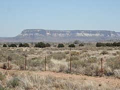
346:Outcrop of Zuni Sandstone at
303:Show map of the United States
348:El Malpais National Monument
328:Zuni Sandstone (New Mexico)
682:
278:
101:
26:
454:History of investigation
164:150 m (490 ft)
526:Anderson, O.J. (1983).
413:Summerville Formations
354:
331:Show map of New Mexico
464:Cow Springs Sandstone
345:
212:35.0525°N 108.7957°W
208: /
28:Stratigraphic range
535:New Mexico Geology
387:to leave a single
383:formations, which
363:geologic formation
355:
217:35.0525; -108.7957
487:Lucas, Spencer G.
440:Wingate Sandstone
340:
339:
155:Wingate Sandstone
673:
645:
644:
642:
640:
624:
618:
617:
615:
591:
585:
584:
582:
580:
557:
551:
550:
548:
546:
532:
523:
514:
513:
511:
509:
495:
483:
448:Dakota Formation
428:Bluff Formations
365:in west-central
332:
323:
322:
316:
304:
295:
294:
288:
223:
222:
220:
219:
218:
213:
209:
206:
205:
204:
201:
141:Dakota Formation
131:San Rafael Group
106:
97:
34:
19:
681:
680:
676:
675:
674:
672:
671:
670:
651:
650:
649:
648:
638:
636:
626:
625:
621:
593:
592:
588:
578:
576:
559:
558:
554:
544:
542:
530:
525:
524:
517:
507:
505:
493:
485:
484:
477:
472:
460:Clarence Dutton
456:
397:
336:
335:
334:
333:
330:
329:
326:
325:
324:
307:
306:
305:
302:
301:
298:
297:
296:
265:Clarence Dutton
216:
214:
210:
207:
202:
199:
197:
195:
194:
112:
96:
95:
90:
85:
80:
75:
70:
65:
60:
55:
50:
45:
40:
33:middle Jurassic
32:
31:
17:
12:
11:
5:
679:
677:
669:
668:
663:
653:
652:
647:
646:
619:
586:
552:
515:
474:
473:
471:
468:
455:
452:
396:
393:
359:Zuni Sandstone
338:
337:
327:
318:
317:
311:
310:
309:
308:
299:
290:
289:
283:
282:
281:
280:
279:
276:
275:
272:
268:
267:
262:
258:
257:
254:
250:
249:
245:
244:
239:
235:
234:
229:
225:
224:
192:
186:
185:
181:
180:
175:
171:
170:
166:
165:
162:
158:
157:
148:
144:
143:
138:
134:
133:
128:
124:
123:
118:
114:
113:
107:
99:
98:
91:
86:
81:
76:
71:
66:
61:
56:
51:
46:
41:
36:
35:
24:
23:
22:Zuni Sandstone
15:
13:
10:
9:
6:
4:
3:
2:
678:
667:
664:
662:
659:
658:
656:
634:
630:
623:
620:
614:
613:10.3133/pp183
609:
605:
601:
597:
590:
587:
574:
570:
566:
562:
556:
553:
540:
536:
529:
522:
520:
516:
503:
499:
492:
488:
482:
480:
476:
469:
467:
465:
461:
453:
451:
449:
445:
441:
438:rests on the
437:
436:unconformably
431:
429:
425:
421:
418:
414:
410:
406:
402:
401:I-40 corridor
394:
392:
390:
386:
382:
379:
375:
372:
368:
364:
360:
353:
349:
344:
315:
287:
277:
273:
269:
266:
263:
259:
255:
251:
246:
243:
242:United States
240:
236:
233:
230:
226:
221:
193:
191:
187:
182:
179:
176:
172:
167:
163:
159:
156:
152:
149:
145:
142:
139:
135:
132:
129:
125:
122:
119:
115:
111:
105:
100:
94:
89:
84:
79:
74:
69:
64:
59:
54:
49:
44:
39:
29:
25:
20:
637:. Retrieved
632:
622:
603:
599:
589:
577:. Retrieved
572:
568:
561:Dutton, C.E.
555:
543:. Retrieved
538:
534:
506:. Retrieved
501:
497:
457:
444:Chinle Group
432:
398:
358:
356:
271:Year defined
256:Zuni Plateau
248:Type section
151:Chinle Group
110:Dowa Yalanne
395:Description
381:sedimentary
215: /
203:108°47′45″W
190:Coordinates
655:Categories
639:29 October
579:29 October
545:29 October
541:(3): 56–60
508:30 October
470:References
378:lacustrine
367:New Mexico
352:New Mexico
232:New Mexico
200:35°03′09″N
575:: 113–198
504:: 135–144
420:sandstone
389:sandstone
385:pinch out
253:Named for
178:Sandstone
169:Lithology
161:Thickness
137:Underlies
127:Sub-units
121:Formation
563:(1885).
489:(2020).
409:Morrison
371:Jurassic
261:Named by
184:Location
147:Overlies
635:. I-981
424:Entrada
405:Todilto
374:fluvial
238:Country
174:Primary
417:eolian
411:, and
391:body.
228:Region
531:(PDF)
494:(PDF)
361:is a
641:2020
581:2020
547:2020
510:2020
426:and
376:and
357:The
274:1885
117:Type
38:PreꞒ
608:doi
604:183
442:or
657::
631:.
606:.
602:.
598:.
571:.
567:.
537:.
533:.
518:^
502:14
500:.
496:.
478:^
450:.
430:.
407:,
350:,
153:.
88:Pg
30::
643:.
616:.
610::
583:.
573:6
549:.
539:5
512:.
93:N
83:K
78:J
73:T
68:P
63:C
58:D
53:S
48:O
43:Ꞓ
Text is available under the Creative Commons Attribution-ShareAlike License. Additional terms may apply.