94:
55:
101:
62:
280:
93:
371:
139:
54:
221:
324:
132:
245:
217:
340:
284:
273:
241:
233:
228:, South Africa. The range of some 70 kilometres long (west to east) is situated at the eastern end of the
244:
further east. Its rugged terrain is intersected by many defiles and ridge lines, rising from some 200 m
237:
268:
320:
292:
279:
261:
248:
in the south to 936 m a.s.l. The southern slopes are drained by various tributaries of the
229:
365:
257:
249:
225:
196:
192:
78:
74:
17:
341:"Zuurberg Mountain Village (also spelt Suurberg) | South African History Online"
253:
154:
141:
276:
are striking plants that are endemic to the mountain range and its vicinity.
319:. Cape Town: Reader's Digest Association South Africa. pp. 94, 96.
256:
rivers. Two passes cross the mountain from south to north, namely the
278:
27:
Mountain range in southern
Eastern Cape, South Africa
188:
183:
175:
170:
131:
126:
36:
8:
315:Walton, Christopher; O'Hagan, Tim (1984).
33:
317:Reader's Digest Atlas of Southern Africa
304:
232:, and rises just north of the towns of
310:
308:
252:, including the Kabouga, Uie, Wit and
7:
295:are thought to be 15 000 years old.
222:Sarah Baartman District Municipality
372:Mountain ranges of the Eastern Cape
25:
100:
99:
92:
61:
60:
53:
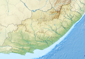
216:) is a mountain range near the
1:
291:Artefacts discovered in the
287:in a valley of the Suurberg
218:Addo Elephant National Park
388:
46:
41:
116:Show map of Eastern Cape
83:Show map of South Africa
179:70 km (43 mi)
113:Suurberg (Eastern Cape)
288:
282:
155:33.27917°S 25.51556°E
345:www.sahistory.org.za
238:Sundays River Valley
236:and Bontrug (in the
269:Oldenburgia grandis
160:-33.27917; 25.51556
151: /
289:
127:Highest point
18:Zuurberg Mountains
293:Melkhoutboom Cave
202:
201:
16:(Redirected from
379:
356:
355:
353:
351:
337:
331:
330:
312:
262:Olifantskop Pass
220:in the southern
166:
165:
163:
162:
161:
156:
152:
149:
148:
147:
144:
117:
103:
102:
96:
84:
64:
63:
57:
34:
21:
387:
386:
382:
381:
380:
378:
377:
376:
362:
361:
360:
359:
349:
347:
339:
338:
334:
327:
314:
313:
306:
301:
285:Suurberg cycads
159:
157:
153:
150:
145:
142:
140:
138:
137:
122:
121:
120:
119:
118:
115:
114:
111:
110:
109:
108:
104:
87:
86:
85:
82:
81:
72:
71:
70:
69:
65:
28:
23:
22:
15:
12:
11:
5:
385:
383:
375:
374:
364:
363:
358:
357:
332:
326:0-947-008-02-0
325:
303:
302:
300:
297:
274:Suurberg cycad
230:Cape Fold Belt
200:
199:
190:
186:
185:
181:
180:
177:
173:
172:
168:
167:
135:
129:
128:
124:
123:
112:
106:
105:
98:
97:
91:
90:
89:
88:
73:
67:
66:
59:
58:
52:
51:
50:
49:
48:
47:
44:
43:
39:
38:
26:
24:
14:
13:
10:
9:
6:
4:
3:
2:
384:
373:
370:
369:
367:
346:
342:
336:
333:
328:
322:
318:
311:
309:
305:
298:
296:
294:
286:
281:
277:
275:
271:
270:
265:
263:
259:
258:Suurberg Pass
255:
251:
250:Sundays River
247:
243:
239:
235:
231:
227:
223:
219:
215:
211:
207:
198:
194:
191:
187:
182:
178:
174:
169:
164:
136:
134:
130:
125:
95:
80:
76:
56:
45:
40:
35:
32:
30:
19:
348:. Retrieved
344:
335:
316:
290:
267:
266:
226:Eastern Cape
213:
209:
205:
203:
197:South Africa
193:Eastern Cape
79:South Africa
75:Eastern Cape
31:
29:
158: /
133:Coordinates
350:26 October
299:References
171:Dimensions
146:25°30′56″E
143:33°16′45″S
214:Suurberge
184:Geography
366:Category
283:Endemic
272:and the
242:Paterson
234:Kirkwood
210:Zuurberg
206:Suurberg
189:Location
107:Suurberg
68:Suurberg
42:Zuurberg
37:Suurberg
240:), and
224:of the
323:
246:a.s.l.
208:(also
176:Length
352:2023
321:ISBN
260:and
254:Krom
204:The
212:or
368::
343:.
307:^
264:.
195:,
77:,
354:.
329:.
20:)
Text is available under the Creative Commons Attribution-ShareAlike License. Additional terms may apply.