30:
37:
290:. The tectonic motion forms a complex zone of subduction and continental collision zones which affect the region. Due to the location at a major plate boundary zone, Papua New Guinea is struck by earthquakes and tsunamis frequently and is one of the world's most seismically active regions.
305:
strata. The range formed as a result of thrusting which began 3.7 million years ago and has an elevation of 4,000 meters. Bedrock landsliding is frequent within the range, caused by rainfall and earthquakes associated with the nearby thrust faults.
325:
about 6 hours after the event. The road network was cut due to the heavy rain, but the injured were evacuated by the helicopters that brought in the rescue workers. The landslide displaced the remaining 138 residents of the village.
449:
424:
321:
Surviving villagers immediately attempted to dig out those who were buried and about 50 survivors were evacuated to higher ground. Word of the disaster reached the provincial authorities in
775:
29:
314:
A massive landslide was triggered by the earthquake, destroying twelve homes in the village of Kobung. Eleven people were injured, two of them seriously, and one was airlifted to
768:
507:
886:
457:
432:
881:
761:
784:
340:
891:
138:
60:
871:
500:
187:
840:
835:
830:
825:
820:
810:
800:
680:
74:
643:
614:
815:
493:
866:
805:
573:
522:
519:
516:
335:
845:
795:
231:
49:
876:
536:
585:
113:
720:
703:
626:
267:
726:
697:
663:
620:
591:
382:
363:
553:
398:
297:
located near the epicenter of the 2002 earthquake is predominantly volcanic in origin, consisting of
283:
271:
79:
66:
471:
406:
402:
294:
259:
227:
173:
298:
235:
287:
279:
275:
263:
860:
255:
239:
223:
753:
410:
153:
140:
383:"Topographic site effects and the location of earthquake induced landslides"
243:
485:
394:
302:
757:
489:
322:
315:
16:
Earthquake and landslides in Morobe
Province, Papua New Guinea
36:
222: 5.3 magnitude earthquake struck near the coast of
381:
Patrick
Meunier; Niels Hovius; John Allan Haines (2008).
741:
indicates earthquake resulting in at least 30 deaths
713:
690:
673:
656:
636:
601:
566:
546:
529:
364:"M 5.3 - 62 km NW of Finschhafen, Papua New Guinea"
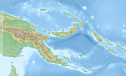
254:Papua New Guinea is situated in a region where the
208:
200:
179:
169:
132:
124:
108:
100:
85:
72:
59:
48:
746:indicates the deadliest earthquake of the year
769:
501:
425:"Papua New Guinea fears 36 dead in landslide"
8:
204:Buried a village, responsible for casualties
19:
776:
762:
754:
508:
494:
486:
18:
234:of 80.5 km beneath the surface and had a
114:
282:is moving north, converging beneath the
352:
341:List of earthquakes in Papua New Guinea
358:
356:
246:that killed 36 people and injured 11.
7:
472:"PNG landslide kills at least eight"
450:"Huge landslide in Papua New Guinea"
444:
442:
387:Earth and Planetary Science Letters
887:2002 disasters in Papua New Guinea
212:36 dead, 11 injured, 138 displaced
14:
35:
28:
882:Earthquakes in Papua New Guinea
785:Earthquakes in Papua New Guinea
180:
1:
242:. The earthquake triggered a
892:April 2002 events in Oceania
336:List of earthquakes in 2002
128:80.5 km (50.0 mi)
908:
411:10.1016/j.epsl.2008.07.020
791:
736:
24:
872:2002 in Papua New Guinea
831:2018 Southern Highlands
403:2008E&PSL.275..221M
20:2002 Morobe earthquake
218:On April 1, 2002, a M
801:1971 Solomon Islands
576:(7.4/6.1, Mar 3/25)
284:South Bismarck Plate
520:Earthquakes in 2002
460:on 6 December 2004.
435:on 6 December 2004.
368:earthquake.usgs.gov
150: /
55:2002-04-01 06:14:15
21:
867:Landslides in 2002
854:
853:
826:2017 Bougainville
751:
750:
238:corresponding to
230:. It struck at a
216:
215:
154:6.191°S 147.421°E
899:
877:2002 earthquakes
816:2000 New Ireland
778:
771:
764:
755:
664:Burica Peninsula
510:
503:
496:
487:
480:
479:
468:
462:
461:
456:. Archived from
446:
437:
436:
431:. Archived from
421:
415:
414:
378:
372:
371:
360:
295:Finisterre Range
250:Tectonic setting
240:reverse faulting
228:Papua New Guinea
196:
194:
182:
174:Papua New Guinea
165:
164:
162:
161:
160:
155:
151:
148:
147:
146:
143:
119:
96:
94:
39:
38:
32:
22:
907:
906:
902:
901:
900:
898:
897:
896:
857:
856:
855:
850:
846:2024 East Sepik
841:2023 East Sepik
836:2022 Finisterre
806:1993 Finisterre
787:
782:
752:
747:
742:
732:
709:
686:
669:
652:
632:
629:(4.8, April 25)
623:(5.7, April 24)
617:(5.1, April 20)
597:
562:
542:
525:
514:
484:
483:
470:
469:
465:
448:
447:
440:
423:
422:
418:
380:
379:
375:
362:
361:
354:
349:
332:
318:for treatment.
312:
299:volcaniclastics
252:
236:focal mechanism
221:
188:
186:
159:-6.191; 147.421
158:
156:
152:
149:
144:
141:
139:
137:
136:
118:
101:Local time
92:
90:
86:Local date
44:
43:
42:
41:
40:
17:
12:
11:
5:
905:
903:
895:
894:
889:
884:
879:
874:
869:
859:
858:
852:
851:
849:
848:
843:
838:
833:
828:
823:
818:
813:
808:
803:
798:
792:
789:
788:
783:
781:
780:
773:
766:
758:
749:
748:
737:
734:
733:
731:
730:
724:
717:
715:
711:
710:
708:
707:
701:
694:
692:
688:
687:
685:
684:
677:
675:
671:
670:
668:
667:
660:
658:
654:
653:
651:
650:
646:(6.5, Jun 22)
640:
638:
634:
633:
631:
630:
624:
618:
615:Au Sable Forks
612:
611:(5.3, April 1)
605:
603:
599:
598:
596:
595:
589:
583:
570:
568:
564:
563:
561:
560:
550:
548:
544:
543:
541:
540:
533:
531:
527:
526:
515:
513:
512:
505:
498:
490:
482:
481:
476:news.bbc.co.uk
463:
438:
416:
373:
351:
350:
348:
345:
344:
343:
338:
331:
328:
311:
308:
288:Markham Valley
280:Woodlark Plate
276:Huon Peninsula
251:
248:
219:
214:
213:
210:
206:
205:
202:
198:
197:
184:
177:
176:
171:
170:Areas affected
167:
166:
134:
130:
129:
126:
122:
121:
116:
110:
106:
105:
102:
98:
97:
87:
83:
82:
77:
70:
69:
64:
57:
56:
53:
46:
45:
34:
33:
27:
26:
25:
15:
13:
10:
9:
6:
4:
3:
2:
904:
893:
890:
888:
885:
883:
880:
878:
875:
873:
870:
868:
865:
864:
862:
847:
844:
842:
839:
837:
834:
832:
829:
827:
824:
822:
819:
817:
814:
812:
809:
807:
804:
802:
799:
797:
794:
793:
790:
786:
779:
774:
772:
767:
765:
760:
759:
756:
745:
740:
735:
728:
725:
722:
719:
718:
716:
712:
706:(5.9, Oct 31)
705:
702:
700:(6.2, Oct 24)
699:
696:
695:
693:
689:
682:
679:
678:
676:
672:
666:(6.5, Jul 30)
665:
662:
661:
659:
655:
649:
645:
642:
641:
639:
635:
628:
625:
622:
619:
616:
613:
610:
607:
606:
604:
600:
594:(7.1, Mar 31)
593:
590:
587:
584:
582:
579:
575:
572:
571:
569:
565:
559:
556:(6.5, Feb 3)
555:
552:
551:
549:
545:
538:
535:
534:
532:
528:
524:
521:
518:
511:
506:
504:
499:
497:
492:
491:
488:
477:
473:
467:
464:
459:
455:
454:reliefweb.int
451:
445:
443:
439:
434:
430:
429:reliefweb.int
426:
420:
417:
412:
408:
404:
400:
396:
392:
388:
384:
377:
374:
369:
365:
359:
357:
353:
346:
342:
339:
337:
334:
333:
329:
327:
324:
319:
317:
309:
307:
304:
300:
296:
291:
289:
285:
281:
277:
273:
269:
265:
261:
257:
249:
247:
245:
241:
237:
233:
229:
225:
224:Moro Province
211:
207:
203:
199:
195:
192:
185:
178:
175:
172:
168:
163:
135:
131:
127:
123:
120:
111:
107:
103:
99:
89:April 1, 2002
88:
84:
81:
78:
76:
71:
68:
65:
62:
58:
54:
51:
47:
31:
23:
811:1998 Sandaun
743:
738:
729:(7.9, Nov 3)
723:(7.3, Nov 2)
683:(7.6, Sep 9)
647:
644:Bou'in-Zahra
608:
588:(7.5, Mar 5)
580:
577:
557:
539:(7.2, Jan 2)
475:
466:
458:the original
453:
433:the original
428:
419:
390:
386:
376:
367:
320:
313:
292:
266:and several
253:
217:
190:
796:1970 Madang
397:: 221–232.
268:microplates
157: /
145:147°25′16″E
63: event
861:Categories
821:2002 Wewak
574:Hindu Kush
347:References
286:along the
272:converging
260:Australian
209:Casualties
201:Landslides
52: time
674:September
537:Port Vila
274:. At the
244:landslide
183:intensity
142:6°11′28″S
133:Epicenter
109:Magnitude
721:Simeulue
714:November
586:Mindanao
547:February
395:Elsevier
330:See also
303:volcanic
264:Caroline
189:MMI IV (
691:October
627:Tbilisi
592:Hualien
530:January
399:Bibcode
393:(3–4).
256:Pacific
93:2002-04
91: (
67:2945331
727:Denali
704:Molise
698:Kalehe
621:Kosovo
609:Morobe
310:Impact
278:, the
80:ComCat
681:Wewak
602:April
567:March
554:Afyon
232:depth
191:Light
125:Depth
104:16:14
73:USGS-
657:July
637:June
301:and
293:The
270:are
181:Max.
112:5.3
75:ANSS
407:doi
391:275
323:Lae
316:Lae
226:in
61:ISC
50:UTC
863::
474:.
452:.
441:^
427:.
405:.
389:.
385:.
366:.
355:^
262:,
258:,
777:e
770:t
763:v
744:‡
739:†
648:†
581:‡
578:†
558:†
523:→
517:←
509:e
502:t
495:v
478:.
413:.
409::
401::
370:.
220:w
193:)
117:w
115:M
95:)
Text is available under the Creative Commons Attribution-ShareAlike License. Additional terms may apply.