145:
165:
347:
24:
172:
475:. The Bridal Veil picnic and camping site is located in a small national park about a 5 km (3.1 mi) walk, or a short drive, from the village. The falls itself plunges 50 m (160 ft) down a sheer rock face into a crystal clear pool. Close to the town are the Arboretum, Green Mount, and Pork Pie sanctuary.
478:
The
Chimanimani Mountains are a short 18 km (11 mi) drive from the village. There are numerous hiking trails throughout the rugged Chimanimani range. Local guides are available. For adventure activities there is an Outward Bound centre nearby. It offers a range of activities and life-skill
718:
655:
644:
479:
programs, accommodation and camping facilities, and access to the
Paradise Pool. Other attractions in the Chimanimani Mountain range include the Nyakwaha and Haroni Botanical Reserves, as well as the Haroni and Mukurupiri waterfalls.
801:
786:
495:
The local economy of
Chimanimani is primarily based on agriculture, with crops such as maize, beans, and vegetables being grown. Livestock farming is also common in the area.
575:
The 1982 national census estimated the population of the town at 1,370. In 2004, the population of
Chimanimani was estimated at 2,752. The next national population census in
463:
of
Zimbabwe and the largest city in that country. The coordinates of the village of Chimanimani are: 19° 48' 0.00"S, 32° 51' 36.00"E (Latitude:19.8000; Longitude:32.8600).
821:
816:
144:
775:
762:
196:
164:
504:
430:
107:
455:, the location of the provincial headquarters. Its location lies approximately 365 kilometres (227 mi), by road, southeast of
292:
619:
368:
45:
411:
88:
530:
in 2019, and was cut off from the regional capital due to damage to roads. The primary school in
Chikukwa was destroyed.
472:
383:
364:
60:
41:
579:
is scheduled from 18 August 2012 through 28 August 2012. Most of the inhabitants of
Chimanimani are of Ndau origin.
390:
67:
357:
34:
598:
487:
Chimanimani receives rainfall throughout the year. The average temperature is about 16 °C (61 °F).
397:
74:
752:
757:
379:
150:
56:
588:
593:
444:
284:
523:, in 1982. However, after consultation with the population, the name was changed to Chimanimani.
726:
507:
and Dunbar Moodie in 1892. In 1895 it was moved to its current site and was officially called
554:
549:
668:"Climate: Chimanimani – Climate graph, Temperature graph, Climate table – Climate-Data.org"
297:
404:
81:
564:
544:
539:
810:
692:
559:
623:
527:
460:
519:. Following Zimbabwe's independence in 1980, the name of the town was changed to
346:
23:
448:
730:
667:
211:
198:
471:
Chimanimani has various nature-based attractions for visitors, most notably
275:
576:
516:
330:
231:
451:. The village lies about 120 kilometres (75 mi), by road, south of
371: in this section. Unsourced material may be challenged and removed.
719:"Tropical Cyclone Idai may have killed more than 1,000 in Mozambique"
512:
456:
452:
280:
340:
307:
17:
787:
Next
Population Census In Zimbabwe Scheduled For August 2012
656:
Map
Showing Harare And Chimanimani With Distance Marker
447:, in south-eastern Zimbabwe, close to the border with
645:
Road
Distance Between Mutare And Chimanimani With Map
303:
291:
274:
266:
261:
253:
245:
237:
227:
125:
48:. Unsourced material may be challenged and removed.
753:"Zimpapers hailed for heeding President's call"
8:
620:"2012 Census Provincial Report: Manicaland"
122:
693:"Chimanimani Biosphere Reserve, Zimbabwe"
431:Learn how and when to remove this message
108:Learn how and when to remove this message
751:Zinyuke, Rumbidzayi (21 November 2020).
503:Chimanimani was founded by the brothers
822:Populated places in Manicaland Province
610:
302:
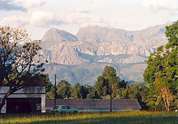
290:
273:
260:
252:
236:
226:
191:
157:
141:
802:Location of Chimanimani At Google Maps
765:from the original on 21 November 2020.
618:Zimbabwe National Statistics Agency.
265:
244:
7:
817:Populated places established in 1892
443:Chimanimani is a village located in
369:adding citations to reliable sources
46:adding citations to reliable sources
184:Location of Chimanimani in Zimbabwe
171:
14:
345:
170:
163:
143:
22:
534:Notable people from Chimanimani
356:needs additional citations for
33:needs additional citations for
511:after Moodie's family home in
1:
776:Estimated Population In 2004
257:1,470 m (4,820 ft)
838:
526:The city was badly hit by
316:(026 from within Zimbabwe)
599:Chimanimani National Park
313:
192:
158:
142:
135:
325:, originally known as
212:19.80000°S 32.86000°E
153:as seen from the town
151:Chimanimani Mountains
761:. Harare, Zimbabwe.
589:Chimanimani District
365:improve this article
42:improve this article
672:en.climate-data.org
594:Manicaland Province
445:Manicaland Province
217:-19.80000; 32.86000
208: /
267: • Total
725:. 19 March 2019.
699:. 21 October 2022
473:Bridal Veil Falls
441:
440:
433:
415:
320:
319:
314:Dialling code: 26
118:
117:
110:
92:
829:
789:
784:
778:
773:
767:
766:
748:
742:
741:
739:
737:
715:
709:
708:
706:
704:
689:
683:
682:
680:
678:
664:
658:
653:
647:
642:
636:
635:
633:
631:
622:. Archived from
615:
555:Tafataona Mahoso
550:Arthur Mutambara
436:
429:
425:
422:
416:
414:
373:
349:
341:
223:
222:
220:
219:
218:
213:
209:
206:
205:
204:
201:
174:
173:
167:
147:
123:
120:Town in Zimbabwe
113:
106:
102:
99:
93:
91:
50:
26:
18:
837:
836:
832:
831:
830:
828:
827:
826:
807:
806:
798:
793:
792:
785:
781:
774:
770:
750:
749:
745:
735:
733:
717:
716:
712:
702:
700:
691:
690:
686:
676:
674:
666:
665:
661:
654:
650:
643:
639:
629:
627:
617:
616:
612:
607:
585:
573:
536:
501:
493:
485:
437:
426:
420:
417:
374:
372:
362:
350:
339:
329:, is a town in
315:
216:
214:
210:
207:
202:
199:
197:
195:
194:
188:
187:
186:
185:
182:
181:
180:
179:
175:
154:
138:
131:
128:
121:
114:
103:
97:
94:
51:
49:
39:
27:
12:
11:
5:
835:
833:
825:
824:
819:
809:
808:
805:
804:
797:
796:External links
794:
791:
790:
779:
768:
743:
710:
684:
659:
648:
637:
626:on 19 May 2018
609:
608:
606:
603:
602:
601:
596:
591:
584:
581:
572:
569:
568:
567:
565:Tendai Chatara
562:
557:
552:
547:
545:Munacho Mutezo
542:
540:Samuel Undenge
535:
532:
500:
497:
492:
489:
484:
481:
439:
438:
353:
351:
344:
338:
335:
318:
317:
311:
310:
305:
301:
300:
295:
289:
288:
278:
272:
271:
268:
264:
263:
259:
258:
255:
251:
250:
247:
243:
242:
239:
235:
234:
229:
225:
224:
190:
189:
183:
177:
176:
169:
168:
162:
161:
160:
159:
156:
155:
148:
140:
139:
136:
133:
132:
129:
126:
119:
116:
115:
30:
28:
21:
13:
10:
9:
6:
4:
3:
2:
834:
823:
820:
818:
815:
814:
812:
803:
800:
799:
795:
788:
783:
780:
777:
772:
769:
764:
760:
759:
754:
747:
744:
732:
728:
724:
723:The Economist
720:
714:
711:
698:
694:
688:
685:
673:
669:
663:
660:
657:
652:
649:
646:
641:
638:
625:
621:
614:
611:
604:
600:
597:
595:
592:
590:
587:
586:
582:
580:
578:
570:
566:
563:
561:
560:John Mangudya
558:
556:
553:
551:
548:
546:
543:
541:
538:
537:
533:
531:
529:
524:
522:
521:Mandidzudzure
518:
514:
510:
506:
505:Thomas Moodie
498:
496:
490:
488:
482:
480:
476:
474:
470:
469:
464:
462:
458:
454:
450:
446:
435:
432:
424:
413:
410:
406:
403:
399:
396:
392:
389:
385:
382: –
381:
380:"Chimanimani"
377:
376:Find sources:
370:
366:
360:
359:
354:This section
352:
348:
343:
342:
336:
334:
332:
328:
324:
312:
309:
306:
299:
296:
294:
286:
282:
279:
277:
269:
256:
248:
240:
233:
230:
221:
193:Coordinates:
166:
152:
146:
134:
124:
112:
109:
101:
98:December 2014
90:
87:
83:
80:
76:
73:
69:
66:
62:
59: –
58:
57:"Chimanimani"
54:
53:Find sources:
47:
43:
37:
36:
31:This article
29:
25:
20:
19:
16:
782:
771:
756:
746:
734:. Retrieved
722:
713:
701:. Retrieved
696:
687:
675:. Retrieved
671:
662:
651:
640:
628:. Retrieved
624:the original
613:
574:
528:Cyclone Idai
525:
520:
508:
502:
494:
486:
477:
468:Main Sights:
467:
466:
465:
442:
427:
418:
408:
401:
394:
387:
375:
363:Please help
358:verification
355:
326:
322:
321:
149:View of the
104:
95:
85:
78:
71:
64:
52:
40:Please help
35:verification
32:
15:
421:August 2023
323:Chimanimani
246:Chimanimani
215: /
178:Chimanimani
127:Chimanimani
811:Categories
758:The Herald
703:19 October
677:16 January
605:References
571:Population
449:Mozambique
391:newspapers
262:Population
203:32°51′36″E
200:19°48′00″S
68:newspapers
731:0013-0613
509:Melsetter
327:Melsetter
276:Time zone
254:Elevation
238:Melsetter
130:Melsetter
763:Archived
736:19 March
583:See also
577:Zimbabwe
517:Scotland
337:Location
331:Zimbabwe
308:Homepage
232:Zimbabwe
499:History
491:Economy
483:Climate
461:capital
405:scholar
304:Website
293:Climate
228:Country
82:scholar
729:
697:UNESCO
630:25 May
513:Orkney
459:, the
457:Harare
453:Mutare
407:
400:
393:
386:
378:
84:
77:
70:
63:
55:
412:JSTOR
398:books
281:UTC+2
270:6,815
89:JSTOR
75:books
738:2019
727:ISSN
705:2023
679:2016
632:2018
384:news
249:1982
241:1892
137:Town
61:news
515:in
367:by
298:Cwb
285:CAT
44:by
813::
755:.
721:.
695:.
670:.
333:.
740:.
707:.
681:.
634:.
434:)
428:(
423:)
419:(
409:·
402:·
395:·
388:·
361:.
287:)
283:(
111:)
105:(
100:)
96:(
86:·
79:·
72:·
65:·
38:.
Text is available under the Creative Commons Attribution-ShareAlike License. Additional terms may apply.