34:
148:
141:
383:
546:
350:
The slopes of the ridges are generally abrupt in the eastern side and more gently sloping in the western. They are deeply dissected by river valleys and ravines. Numerous rivers have their origin in the range, but their waters are mostly lost either in the sands of the surrounding deserts or in
33:
339:(Қаншыңғыс), highest point 1,152 meters (3,780 ft) in the northern section, the Chingiztau proper in the middle, highest point 1,119 meters (3,671 ft), and
331:
system (Saryarka). It stretches roughly for about 200 kilometers (120 mi) from northwest to southeast, 30 kilometers (19 mi) to the south of the
190:
76:
140:
582:
343:(Ақшатау) in the southern section, where there is highest point of the whole range system 1,304 meters (4,278 ft) Mount
183:
69:
449:/ Ch. ed. B.O. Jakyp. — Almaty: « Kazakh encyclopedia» ZhSS, 2011. ISBN 9965-893-64-0 (T.Z.), ISBN 9965-893-19-5
375:
cave (Қоңыр әулие үңгірі) is located near Mount Aktas, off the western slopes of the range, near the Shagan river.
523:
577:
424:
550:
253:
507:
372:
263:
368:
360:
561:
344:
52:
400:
364:
356:
293:
528:
328:
301:
246:
229:
222:
382:
571:
472:
355:
of the highlands. The largest rivers having their sources in the
Chingiztau are the
556:
461:
305:
280:
487:
309:
176:
161:
205:
192:
91:
78:
518:
352:
276:
268:
545:
332:
241:
412:
316:
59:
408:
404:
381:
272:
562:
General physical and geographical conditions of East
Kazakhstan
531:. - 3rd ed. - M. Soviet Encyclopedia, 1969–1978. (in Russian)
327:
Chingiztau is one of the ranges of the eastern part of the
262:
252:
240:
235:
221:
182:
172:
128:
120:
112:
107:
68:
58:
48:
43:
21:
319:, located near the southern end of the range.
8:
363:flowing roughly northwards, as well as the
18:
335:. The range has three separate ridges:
436:
488:"M-44 Topographic Chart (in Russian)"
482:
480:
116:200 km (120 mi) NW / SE
7:
457:
455:
442:
440:
508:Пещера Коныр-Аулие - QazaqGeography
124:50 km (31 mi) NE / SW
147:
14:
544:
447:Kazakhstan National Encyclopedia
399:The range slopes are covered by
146:
139:
32:
16:Range of mountains in Kazakhstan
1:
367:and a few tributaries of the
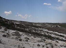
38:View of the Akshatau subrange
359:and its right tributary the
64:1,304 m (4,278 ft)
473:Toponyms – Чингизтау хребет
386:Near the Konyr-Auliye cave.
599:
379:
524:Great Soviet Encyclopedia
415:thickets in the valleys.
297:
133:
31:
26:
583:Geography of Abai Region
527:in 30 vols. — Ch. ed.
425:Geography of Kazakhstan
403:vegetation. There are
387:
385:
92:48.25056°N 79.66306°E
553:at Wikimedia Commons
315:The nearest city is
371:flowing south. The
202: /
88: /
388:
97:48.25056; 79.66306
44:Highest point
549:Media related to
392:
391:
287:
286:
206:48.633°N 79.167°E
184:Range coordinates
590:
557:Visit Kazakhstan
548:
532:
516:
510:
505:
499:
498:
496:
494:
484:
475:
470:
464:
459:
450:
444:
378:
377:
299:
225:
217:
216:
214:
213:
212:
207:
203:
200:
199:
198:
195:
150:
149:
143:
103:
102:
100:
99:
98:
93:
89:
86:
85:
84:
81:
36:
19:
598:
597:
593:
592:
591:
589:
588:
587:
568:
567:
541:
536:
535:
517:
513:
506:
502:
492:
490:
486:
485:
478:
471:
467:
460:
453:
445:
438:
433:
421:
401:mountain steppe
397:
325:
223:
210:
208:
204:
201:
196:
193:
191:
189:
188:
168:
167:
166:
165:
164:
158:
157:
156:
155:
151:
96:
94:
90:
87:
82:
79:
77:
75:
74:
39:
17:
12:
11:
5:
596:
594:
586:
585:
580:
578:Kazakh Uplands
570:
569:
566:
565:
559:
554:
540:
539:External links
537:
534:
533:
529:A.M. Prokhorov
511:
500:
476:
465:
451:
435:
434:
432:
429:
428:
427:
420:
417:
396:
393:
390:
389:
324:
321:
302:mountain range
285:
284:
266:
260:
259:
256:
250:
249:
247:Alpine orogeny
244:
238:
237:
233:
232:
230:Kazakh Uplands
227:
219:
218:
211:48.633; 79.167
186:
180:
179:
174:
170:
169:
159:
153:
152:
145:
144:
138:
137:
136:
135:
134:
131:
130:
126:
125:
122:
118:
117:
114:
110:
109:
105:
104:
72:
66:
65:
62:
56:
55:
50:
46:
45:
41:
40:
37:
29:
28:
24:
23:
15:
13:
10:
9:
6:
4:
3:
2:
595:
584:
581:
579:
576:
575:
573:
563:
560:
558:
555:
552:
547:
543:
542:
538:
530:
526:
525:
520:
515:
512:
509:
504:
501:
489:
483:
481:
477:
474:
469:
466:
463:
458:
456:
452:
448:
443:
441:
437:
430:
426:
423:
422:
418:
416:
414:
410:
406:
402:
394:
384:
380:
376:
374:
370:
366:
362:
358:
354:
348:
346:
342:
338:
334:
330:
329:Kazakh Upland
322:
320:
318:
313:
311:
307:
303:
295:
291:
282:
278:
274:
270:
267:
265:
261:
257:
255:
251:
248:
245:
243:
239:
234:
231:
228:
226:
220:
215:
187:
185:
181:
178:
175:
171:
163:
142:
132:
127:
123:
119:
115:
111:
106:
101:
73:
71:
67:
63:
61:
57:
54:
51:
47:
42:
35:
30:
25:
20:
564:(in Russian)
522:
514:
503:
491:. Retrieved
468:
462:Google Earth
446:
411:forests and
398:
373:Konyr-Auliye
349:
340:
336:
326:
314:
289:
288:
264:Type of rock
224:Parent range
160:Location in
306:Abai Region
281:porphyritic
254:Age of rock
209: /
95: /
70:Coordinates
572:Categories
551:Chingiztau
431:References
353:salt lakes
337:Kanchingiz
310:Kazakhstan
290:Chingiztau
177:Kazakhstan
162:Kazakhstan
154:Chingiztau
108:Dimensions
83:79°39′47″E
80:48°15′02″N
22:Chingiztau
519:Чингизтау
493:4 October
351:seasonal
323:Geography
298:Шыңғыстау
277:limestone
269:Sandstone
258:Paleozoic
129:Geography
60:Elevation
27:Шыңғыстау
419:See also
361:Ashchysu
341:Akshatau
173:Location
365:Bakanas
333:Degelen
300:) is a
242:Orogeny
236:Geology
197:79°10′E
194:48°38′N
413:willow
369:Ayagöz
357:Shagan
345:Kosoba
317:Ayagoz
294:Kazakh
113:Length
53:Kosoba
409:birch
405:aspen
395:Flora
283:rocks
273:shale
121:Width
495:2022
49:Peak
347:.
304:in
574::
521:;
479:^
454:^
439:^
312:.
308:,
296::
279:,
275:,
271:,
497:.
407:-
292:(
Text is available under the Creative Commons Attribution-ShareAlike License. Additional terms may apply.