50:
34:
619:
57:
418:
River
Parrett. One derivation of -wich is thought to be from Latin 'vicus', and there are archaeological indications that there was a settlement at Combwich in the Romano-British period, based around a ferry across the Parrett at this point. The exact meaning of the second element here is uncertain at present, as Old English
229:
425:
It served as a port for the export of local produce and the import of timber from the 15th century. It also served the local brick and coal yard until the creek silted up in the 1930s. Brick and tile making was first recorded in the village in 1842. As of 2019, Combwich wharf is being used for the
417:
it was known as Comiz which means 'The settlement at the short, broad, open valley' (from Old
English cumb). This is clearly a reference to the valley of exactly this topographical description, immediately to the south of the village, and through which the South Moor Brook flows westwards into the
269:
133:
253:
578:
88:
246:
654:
433:
The Steart
Peninsula has flooded many times during the last millennium. The most severe recent floods occurred in 1981. By 1997, a combination of
277:
215:
427:
241:
536:
378:
553:
49:
313:
295:
258:
203:
169:
644:
234:
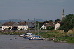
81:
589:
441:
and wave action had made some of the defences distinctly fragile and at risk from failure. As a result, in 2002 The
305:
300:
649:
183:
623:
115:
490:
442:
159:
151:
532:
403:
352:
208:
434:
438:
638:
414:
410:
387:
105:
97:
33:
486:
449:
to
Combwich Coastal Defence Strategy Study to examine options for the future.
399:
328:
315:
391:
193:
123:
618:
446:
395:
141:
70:
413:
flows to the sea and was the site of an ancient ferry crossing. In the
175:
629:
370:
367:
361:
579:"Stolford to Combwich Coastal Defence Strategy Study"
379:
358:
364:
355:
268:
252:
240:
228:
214:
202:
192:
182:
168:
150:
132:
114:
96:
80:
26:
422:can have a variety of meanings attributed to it.
487:"COMBWICH PONDS, COMBWICH, BRIDGWATER, SOMERSET"
475:. London: Christopher Johnson. pp. 117–118.
426:delivery of large equipment for the building of
554:"Hinkley C barge dwarfs the wharf at Combwich"
466:
464:
462:
8:
409:The village lies on Combwich Reach as the
23:
458:
267:
223:
191:
167:
79:
30:
493:from the original on 12 December 2021
428:Hinkley Point C nuclear power station
251:
239:
227:
213:
201:
181:
149:
131:
113:
7:
14:
617:
386:) is a village in the parish of
351:
56:
55:
48:
32:
655:Ports and harbours of Somerset
552:Salter, Steven (7 June 2019).
1:
514:The Landscape of Place-Names
16:Village in Somerset, England
82:OS grid reference
21:Human settlement in England
671:
512:Gelling, Margaret (2000).
529:Portrait of the Quantocks
286:
264:
224:
43:
31:
531:. London: Robert Hale.
527:Waite, Vincent (1964).
471:Farr, Grahame (1954).
204:Postcode district
645:Villages in Sedgemoor
626:at Wikimedia Commons
595:on 27 September 2007
184:Sovereign state
325: /
586:Environment Agency
558:Bridgwater Mercury
443:Environment Agency
329:51.1768°N 3.0671°W
270:UK Parliament
247:Devon and Somerset
216:Dialling code
622:Media related to
473:Somerset Harbours
344:
343:
235:Avon and Somerset
134:Shire county
662:
621:
605:
604:
602:
600:
594:
588:. Archived from
583:
575:
569:
568:
566:
564:
549:
543:
542:
524:
518:
517:
509:
503:
502:
500:
498:
483:
477:
476:
468:
404:Steart Peninsula
382:
377:
376:
373:
372:
369:
366:
363:
360:
357:
340:
339:
337:
336:
335:
334:51.1768; -3.0671
330:
326:
323:
322:
321:
318:
292:
178:
92:
91:
69:Location within
59:
58:
52:
38:Combwich Harbour
36:
24:
670:
669:
665:
664:
663:
661:
660:
659:
650:Somerset Levels
635:
634:
630:Village website
614:
609:
608:
598:
596:
592:
581:
577:
576:
572:
562:
560:
551:
550:
546:
539:
526:
525:
521:
511:
510:
506:
496:
494:
485:
484:
480:
470:
469:
460:
455:
435:coastal erosion
380:
354:
350:
333:
331:
327:
324:
319:
316:
314:
312:
311:
310:
290:
282:
174:
164:
146:
128:
110:
87:
86:
76:
75:
74:
73:
67:
66:
65:
64:
60:
39:
22:
17:
12:
11:
5:
668:
666:
658:
657:
652:
647:
637:
636:
633:
632:
627:
613:
612:External links
610:
607:
606:
570:
544:
537:
519:
504:
478:
457:
456:
454:
451:
439:sea level rise
342:
341:
309:
308:
303:
298:
293:
291:List of places
287:
284:
283:
281:
280:
274:
272:
266:
265:
262:
261:
256:
250:
249:
244:
238:
237:
232:
226:
225:
222:
221:
218:
212:
211:
206:
200:
199:
196:
190:
189:
188:United Kingdom
186:
180:
179:
172:
166:
165:
163:
162:
156:
154:
148:
147:
145:
144:
138:
136:
130:
129:
127:
126:
120:
118:
112:
111:
109:
108:
102:
100:
94:
93:
84:
78:
77:
68:
62:
61:
54:
53:
47:
46:
45:
44:
41:
40:
37:
29:
28:
20:
15:
13:
10:
9:
6:
4:
3:
2:
667:
656:
653:
651:
648:
646:
643:
642:
640:
631:
628:
625:
620:
616:
615:
611:
591:
587:
580:
574:
571:
559:
555:
548:
545:
540:
538:0-7091-1158-4
534:
530:
523:
520:
516:. Shaun Tyas.
515:
508:
505:
492:
488:
482:
479:
474:
467:
465:
463:
459:
452:
450:
448:
445:produced the
444:
440:
436:
431:
429:
423:
421:
416:
415:Domesday book
412:
411:River Parrett
407:
405:
401:
397:
393:
389:
385:
384:
375:
348:
338:
307:
304:
302:
299:
297:
294:
289:
288:
285:
279:
276:
275:
273:
271:
263:
260:
259:South Western
257:
255:
248:
245:
243:
236:
233:
231:
219:
217:
210:
207:
205:
197:
195:
187:
185:
177:
173:
171:
161:
158:
157:
155:
153:
143:
140:
139:
137:
135:
125:
122:
121:
119:
117:
107:
104:
103:
101:
99:
95:
90:
85:
83:
72:
51:
42:
35:
25:
19:
597:. Retrieved
590:the original
585:
573:
561:. Retrieved
557:
547:
528:
522:
513:
507:
495:. Retrieved
481:
472:
432:
424:
419:
408:
394:district of
388:Otterhampton
346:
345:
106:Otterhampton
98:Civil parish
18:
390:within the
332: /
639:Categories
599:31 October
563:6 December
453:References
400:Bridgwater
398:, between
317:51°10′36″N
278:Bridgwater
198:Bridgwater
160:South West
392:Sedgemoor
320:3°04′02″W
254:Ambulance
194:Post town
124:Sedgemoor
624:Combwich
491:Archived
447:Stolford
402:and the
396:Somerset
347:Combwich
306:Somerset
142:Somerset
116:District
89:ST258423
71:Somerset
63:Combwich
27:Combwich
301:England
176:England
170:Country
535:
497:31 May
230:Police
152:Region
593:(PDF)
582:(PDF)
220:01278
601:2007
565:2019
533:ISBN
499:2020
420:-wic
242:Fire
383:-ij
381:KUM
209:TA5
641::
584:.
556:.
489:.
461:^
437:,
430:.
406:.
371:dʒ
296:UK
603:.
567:.
541:.
501:.
374:/
368:ɪ
365:m
362:ʌ
359:k
356:ˈ
353:/
349:(
Text is available under the Creative Commons Attribution-ShareAlike License. Additional terms may apply.