63:
51:
415:. The Rio Conchos region is significant not only for its surface water biota, but also its specialized spring and cave habitats, which contribute to the region's high endemism. However, conditions are being damaged by industrial pollution, sewage, agricultural wastes, flow regulation,
394:
conservation. The WWF's assessment of the Rio
Conchos rates its biological distinctiveness as "globally outstanding" and its conservation status as critically endangered, putting it in the "priority I" category of needing conservation attention.
410:
fish fauna. Twelve of its forty-seven native fish are endemic, as are twelve of its 46 native reptile and amphibian species. The strong biodiversity has survived in part because the river's ecology has not been affected by
315:
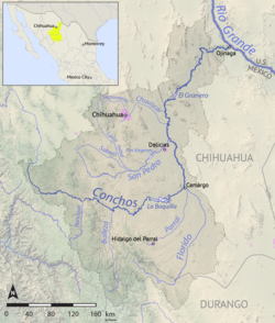
The Rio
Conchos is the main river in the state of Chihuahua and the Rio Grande's largest tributary. The Conchos has several reservoirs that make use of its water for agricultural and hydropower uses.
615:
600:
484:
233:
461:
595:
551:
517:
442:
605:
437:
481:"Water Bulletin Number 75: Flow of the Rio Grande and Related Data; From Elephant Butte Dam, New Mexico to the Gulf of Mexico"
566:
De la Maza-Benignos, M. (ed). 2009. Los Peces del Río
Conchos. Alianza World Wildlife Fund-Fundación Gonzalo Río Arronte
168:
423:. Other threats include poor land and water management practices, such as clear-cutting along the upper Rio Conchos.
610:
379:
590:
432:
324:
114:
359:
387:
585:
403:
328:
126:
465:
358:, entering the Chihuahua Desert and cutting a path through it, before turning to the northeast. At
355:
340:
416:
344:
304:
237:
154:
35:
547:
513:
507:
412:
398:
The Rio
Conchos contains the only free-flowing large river environment left in the Rio Grande
332:
292:
95:
537:
336:
567:
536:
Abell, Robin A.; David M. Olsen; Eric
Dinerstein; Patrick T. Hurley; et al. (2000).
30:
This article is about the river in Mexico. For the river in the U.S. state of Texas, see
390:(rivers systems and lakes, for example) that the WWF considers of global importance for
480:
399:
366:, then cuts through the Peguis Canyon, before forming a last dam (Toribio Ortega) near
363:
579:
348:
300:
288:
67:
Map of the Rio Grande watershed, showing the Rio
Conchos joining the Rio Grande near
543:
391:
31:
420:
137:
62:
50:
383:
296:
142:
183:
170:
407:
331:, where it heads east and receives several tributaries along the way. At
343:. It then heads east again, forming Colina Lake and then passes through
367:
68:
17:
85:
347:, the main agricultural center in the region, where it receives the
354:
From there, the
Conchos heads north, receiving the San Pedro near
539:
Freshwater
Ecoregions of North America: A Conservation Assessment
370:. At Ojinaga, it joins the Rio Bravo (Rio Grande in the U.S.).
406:
habitat ecosystems are relatively intact and support a highly
386:
Freshwater
Ecoregions assessment. The Global 200 is a list of
568:
http://awsassets.panda.org/downloads/peces2010_web.pdf
263:
253:
243:
227:
219:
207:
199:
160:
148:
136:
120:
110:
101:
91:
81:
76:
43:
335:municipality, Chihuahua, it is stopped at the
506:Benke, Arthur C.; Colbert E. Cushing (2005).
8:
485:International Boundary and Water Commission
382:(WWF) has included the Rio Conchos in its
269:1,490 m/s (53,000 cu ft/s)
454:
211:68,400 km (26,400 sq mi)
27:River in the Mexican state of Chihuahua
616:Natural history of the Mexican Plateau
475:
473:
40:
601:Rivers of the Sierra Madre Occidental
531:
529:
443:List of tributaries of the Rio Grande
259:0.09 m/s (3.2 cu ft/s)
7:
512:. Academic Press. pp. 186–192.
339:, the largest in Chihuahua forming
249:24 m/s (850 cu ft/s)
303:as the Rio Grande) at the town of
25:
438:List of longest rivers of Mexico
61:
49:
162: • coordinates
1:
596:Tributaries of the Rio Grande
546:. pp. 93, 103, 188–189.
102:Physical characteristics
34:. For the 1964 Western, see
606:Rivers of Chihuahua (state)
229: • location
150: • location
122: • location
632:
380:World Wide Fund for Nature
287:) is a large river in the
265: • maximum
255: • minimum
245: • average
29:
323:The Conchos rises in the
273:
236:station 08-3730.00, near
215:
203:560 km (350 mi)
132:
106:
60:
48:
433:List of rivers of Mexico
509:Rivers of North America
327:in the municipality of
325:Sierra Madre Occidental
115:Sierra Madre Occidental
362:, it is dammed by the
413:channel modifications
388:freshwater ecoregions
127:Guadalupe, Chihuahua
466:GEOnet Names Server
356:Delicias, Chihuahua
297:Río Bravo del Norte
180: /
345:Camargo, Chihuahua
329:Bocoyna, Chihuahua
305:Ojinaga, Chihuahua
184:29.583°N 104.417°W
155:Ojinaga, Chihuahua
55:Map of the Conchos
36:Rio Conchos (film)
611:Chihuahuan Desert
553:978-1-55963-734-3
519:978-0-12-088253-3
360:Aldama, Chihuahua
333:Valle de Zaragoza
277:
276:
96:Chihuahua (state)
16:(Redirected from
623:
591:Rivers of Mexico
570:
564:
558:
557:
533:
524:
523:
503:
497:
496:
494:
492:
477:
468:
459:
402:. Its river and
364:Presa El Granero
351:as a tributary.
266:
256:
246:
230:
195:
194:
192:
191:
190:
189:29.583; -104.417
185:
181:
178:
177:
176:
173:
123:
65:
53:
41:
21:
631:
630:
626:
625:
624:
622:
621:
620:
576:
575:
574:
573:
565:
561:
554:
535:
534:
527:
520:
505:
504:
500:
490:
488:
479:
478:
471:
460:
456:
451:
429:
376:
337:La Boquilla Dam
321:
313:
295:. It joins the
264:
254:
244:
228:
188:
186:
182:
179:
174:
171:
169:
167:
166:
163:
151:
121:
72:
56:
39:
28:
23:
22:
15:
12:
11:
5:
629:
627:
619:
618:
613:
608:
603:
598:
593:
588:
578:
577:
572:
571:
559:
552:
525:
518:
498:
469:
453:
452:
450:
447:
446:
445:
440:
435:
428:
425:
417:exotic species
400:drainage basin
375:
372:
320:
317:
312:
309:
299:(known in the
275:
274:
271:
270:
267:
261:
260:
257:
251:
250:
247:
241:
240:
231:
225:
224:
221:
217:
216:
213:
212:
209:
205:
204:
201:
197:
196:
164:
161:
158:
157:
152:
149:
146:
145:
140:
134:
133:
130:
129:
124:
118:
117:
112:
108:
107:
104:
103:
99:
98:
93:
89:
88:
83:
79:
78:
74:
73:
66:
58:
57:
54:
46:
45:
26:
24:
14:
13:
10:
9:
6:
4:
3:
2:
628:
617:
614:
612:
609:
607:
604:
602:
599:
597:
594:
592:
589:
587:
584:
583:
581:
569:
563:
560:
555:
549:
545:
541:
540:
532:
530:
526:
521:
515:
511:
510:
502:
499:
486:
482:
476:
474:
470:
467:
463:
458:
455:
448:
444:
441:
439:
436:
434:
431:
430:
426:
424:
422:
418:
414:
409:
405:
401:
396:
393:
389:
385:
381:
373:
371:
369:
365:
361:
357:
352:
350:
346:
342:
338:
334:
330:
326:
318:
316:
310:
308:
306:
302:
301:United States
298:
294:
290:
289:Mexican state
286:
285:Conchos River
282:
272:
268:
262:
258:
252:
248:
242:
239:
235:
232:
226:
222:
218:
214:
210:
206:
202:
198:
193:
165:
159:
156:
153:
147:
144:
141:
139:
135:
131:
128:
125:
119:
116:
113:
109:
105:
100:
97:
94:
90:
87:
84:
80:
75:
70:
64:
59:
52:
47:
42:
37:
33:
19:
562:
544:Island Press
538:
508:
501:
489:. Retrieved
457:
397:
392:biodiversity
377:
353:
341:Toronto Lake
322:
314:
284:
280:
278:
32:Concho River
586:Rio Conchos
462:Rio Conchos
421:overgrazing
311:Description
281:Río Conchos
187: /
44:Río Conchos
580:Categories
449:References
384:Global 200
208:Basin size
143:Rio Grande
293:Chihuahua
220:Discharge
427:See also
175:104°25′W
77:Location
491:17 July
408:endemic
374:Ecology
368:Ojinaga
349:Florido
238:Ojinaga
172:29°35′N
82:Country
69:Ojinaga
18:Conchos
550:
516:
487:. 2005
419:, and
404:spring
319:Course
223:
200:Length
111:Source
86:Mexico
138:Mouth
92:State
548:ISBN
514:ISBN
493:2010
378:The
279:The
234:IBWC
464:at
291:of
582::
542:.
528:^
483:.
472:^
307:.
556:.
522:.
495:.
283:(
71:.
38:.
20:)
Text is available under the Creative Commons Attribution-ShareAlike License. Additional terms may apply.