398:
409:
144:
38:
303:
572:) produce finely laminated flagstones, which were widely used on building on the Shropshire–Montgomeryshire border. Only a few buildings still have the flagstones as roofing slates, including the Old Post Office at
520:
did not employ the same flaking techniques as flint stone axes, which leave recognisable flaking debris, the site or sites of the
Corndon Group XII implements production will be harder to identify. However, the
426:
near the hill summit, and several more exist in the area around the summit. Such circular stone burial cairns are common on most summits in Wales, and they commonly date from ca 2500 BC until ca 700 BC, when
758:
243:
709:
544:, and stretching across to East Anglia. By 1988, 93 examples of these implements had been identified; all of these implements have shaft holes for
768:
748:
296:
200:
397:
121:
763:
633:
522:
408:
59:
102:
237:
55:
74:
457:
lie at the foot of the hill within
Shropshire and Powys respectively. There is another circle nearby in Shropshire, the
512:, and the Hyssington/Corndon Hill implements are known as Group XII. As the production of these implements in the Late
288:
81:
753:
526:
454:
323:
143:
481:
88:
560:
times. From the air, the quarries are still a prominent feature in the landscape. In this area, the altered
48:
361:
range, which lies mainly to the north, east and south of the summit. The immediate area to the west is the
292:
183:
173:
70:
534:
593:
334:
for example. There are spectacular panoramic views from the summit, and it is itself an important
443:
378:
370:
362:
195:
525:
did excavate several small quarry depressions in 2008, but found only evidence of fairly recent
450:
331:
149:
339:
307:
696:
556:
The
Corndon flagstone quarries are on the south-western slopes of Corndon Hill and date from
358:
230:
326:. Corndon's prominent western edge appears to form a separate hill and is known locally as
256:
251:
95:
697:"Corndon Hill burial cairns and Mitchell's Fold stone circle [self-guided walk]"
330:(Welsh: 'Big Hill'). It is frequented by walkers and ramblers from car parks nearby, at
489:
465:
272:
223:
640:
742:
436:
412:
690:
573:
501:
446:
382:
374:
366:
343:
188:
540:
The main distribution of Group XII implements is in mid-Wales, the
Midlands, the
634:"A Potential Axe Factory at Cwm Mawr, Hyssington, Powys: Interim report 2007-08"
557:
468:, built during the 8th century to mark the border between Wales and England (or
37:
565:
561:
517:
485:
458:
420:
401:
347:
319:
724:
711:
664:"Clough" and "Cummins", 1988, Table 2, pg.4 & distribution map 11, pg275
541:
530:
513:
509:
505:
386:
284:
500:
which had been quarried from
Corndon Hill. Picrite is a hard volcanic or
335:
569:
545:
497:
354:
315:
302:
17:
529:. A stone slab with striations, which was suggested was an example of
439:, which are often placed within a stone cyst or box within the mound.
691:
www.geograph.co.uk : photos of
Corndon Hill and surrounding area
493:
469:
432:
163:
548:, and there are no examples of picrite being used to produce axes.
435:
for tools and other goods. Such cairns usually contain one or more
423:
407:
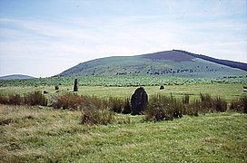
396:
301:
280:
215:
428:
31:
533:
art, could equally well have been early plough marks or a
620:
A new centre of stone axe dispersal on the Welsh Border
484:
identified the source of the rock used for shaft-hole
287:, whose summit rises to 513.6 metres (1,685 ft)
250:
236:
222:
211:
206:
194:
182:
172:
162:
157:
136:
62:. Unsourced material may be challenged and removed.
759:Sites of Special Scientific Interest in Montgomery
464:The hill lies about 4 miles (6.4 km) east of
295:of 203.1 metres (666 ft), so is listed as a
618:Shotton F W, Chitty L F and Seaby W A, (1951),
508:and shaft-hole implements have been grouped by
338:for the surrounding countryside and towns like
8:
133:
122:Learn how and when to remove this message
373:are visible beyond to the far west. The
322:, and forms a prominent landmark in the
585:
314:It is surrounded on three sides by the
568:Period on the margin of the dolerite (
381:lie to the immediate north-east, with
7:
576:and the porch to Hurdley Farmhouse.
60:adding citations to reliable sources
702:. Clwyd-Powys Archaeological Trust.
622:, Proc. Prehist. Soc Vol 17, 159-67
404:cairn on the summit of Corndon Hill
675:Vernacular Buildings of Shropshire
632:Clwyd-Powys Archaeological Trust.
342:. It is close to villages such as
25:
480:In 1951 Professor F W Shotton of
523:Clwyd-Powys Archaeological Trust
504:rock. Production sites of stone
415:looking NNE towards Corndon Hill
142:
36:
47:needs additional citations for
769:Mountains and hills of England
453:and the now largely destroyed
1:
476:Stone Axe Factory (Group XII)
749:Mountains and hills of Powys
537:for sharpening stone edges
431:slowly started to displace
152:stone circle, looking south
785:
306:Corndon Hill as seen from
168:514 m (1,686 ft)
27:Mountain in United Kingdom
141:
178:203 m (666 ft)
764:Landforms of Shropshire
148:Corndon Hill above the
598:www.hill-bagging.co.uk
416:
405:
311:
293:topographic prominence
276:
482:Birmingham University
411:
400:
305:
725:52.56548°N 3.02528°W
324:England–Wales border
56:improve this article
721: /
730:52.56548; -3.02528
673:Moran M., (2003),
417:
406:
371:Cambrian Mountains
363:Vale of Montgomery
312:
158:Highest point
754:Marilyns of Wales
419:There is a large
266:
265:
132:
131:
124:
106:
16:(Redirected from
776:
736:
735:
733:
732:
731:
726:
722:
719:
718:
717:
714:
703:
701:
678:
671:
665:
662:
656:
655:
653:
651:
645:
639:. Archived from
638:
629:
623:
616:
610:
609:
607:
605:
590:
359:Shropshire Hills
246:
231:Shropshire Hills
226:
146:
134:
127:
120:
116:
113:
107:
105:
64:
40:
32:
21:
784:
783:
779:
778:
777:
775:
774:
773:
739:
738:
729:
727:
723:
720:
715:
712:
710:
708:
707:
699:
695:
687:
682:
681:
672:
668:
663:
659:
649:
647:
646:on 4 March 2016
643:
636:
631:
630:
626:
617:
613:
603:
601:
592:
591:
587:
582:
554:
490:splitting mauls
478:
451:Mitchell's Fold
395:
332:Mitchell's Fold
289:above sea level
279:) is a hill in
242:
224:
153:
150:Mitchell's Fold
128:
117:
111:
108:
65:
63:
53:
41:
28:
23:
22:
15:
12:
11:
5:
782:
780:
772:
771:
766:
761:
756:
751:
741:
740:
705:
704:
693:
686:
685:External links
683:
680:
679:
666:
657:
624:
611:
600:. Hill Bagging
594:"Corndon Hill"
584:
583:
581:
578:
553:
550:
477:
474:
455:The Whetstones
437:cremation urns
394:
391:
310:, looking east
264:
263:
254:
248:
247:
240:
234:
233:
228:
220:
219:
213:
209:
208:
204:
203:
198:
192:
191:
186:
180:
179:
176:
170:
169:
166:
160:
159:
155:
154:
147:
139:
138:
130:
129:
71:"Corndon Hill"
44:
42:
35:
26:
24:
14:
13:
10:
9:
6:
4:
3:
2:
781:
770:
767:
765:
762:
760:
757:
755:
752:
750:
747:
746:
744:
737:
734:
698:
694:
692:
689:
688:
684:
676:
670:
667:
661:
658:
642:
635:
628:
625:
621:
615:
612:
599:
595:
589:
586:
579:
577:
575:
571:
567:
563:
559:
551:
549:
547:
543:
538:
536:
532:
528:
524:
519:
515:
511:
507:
503:
499:
495:
491:
487:
483:
475:
473:
471:
467:
462:
460:
456:
452:
448:
447:stone circles
445:
440:
438:
434:
430:
425:
422:
414:
413:Roundton Hill
410:
403:
399:
392:
390:
389:to the east.
388:
384:
380:
376:
372:
368:
364:
360:
356:
351:
349:
345:
341:
337:
333:
329:
325:
321:
317:
309:
304:
300:
298:
294:
290:
286:
282:
278:
274:
270:
261:
258:
255:
253:
249:
245:
241:
239:
235:
232:
229:
227:
221:
217:
214:
210:
205:
202:
199:
197:
193:
190:
187:
185:
181:
177:
175:
171:
167:
165:
161:
156:
151:
145:
140:
135:
126:
123:
115:
104:
101:
97:
94:
90:
87:
83:
80:
76:
73: –
72:
68:
67:Find sources:
61:
57:
51:
50:
45:This article
43:
39:
34:
33:
30:
19:
706:
674:
669:
660:
648:. Retrieved
641:the original
627:
619:
614:
602:. Retrieved
597:
588:
574:Church Stoke
555:
539:
479:
463:
441:
418:
383:Caer Caradoc
375:Stiperstones
367:River Severn
357:part of the
355:geologically
353:The hill is
352:
344:Church Stoke
327:
313:
269:Corndon Hill
268:
267:
259:
225:Parent range
189:Stiperstones
137:Corndon Hill
118:
109:
99:
92:
85:
78:
66:
54:Please help
49:verification
46:
29:
728: /
562:Hope Shales
527:disturbance
486:battle axes
466:Offa's Dyke
393:Archaeology
291:. It has a
184:Parent peak
743:Categories
713:52°33′56″N
580:References
566:Ordovician
518:Bronze Age
516:and Early
459:Hoarstones
444:Bronze Age
421:Bronze Age
402:Bronze Age
348:Hyssington
340:Montgomery
320:Shropshire
318:county of
308:Montgomery
260:Landranger
174:Prominence
112:March 2020
82:newspapers
716:3°01′31″W
650:9 January
552:Quarrying
542:Cotswolds
531:Neolithic
514:Neolithic
510:petrology
506:hand axes
387:Long Mynd
285:Mid Wales
207:Geography
164:Elevation
558:medieval
492:and axe
385:and the
365:and the
336:landmark
328:Lan Fawr
277:Cornatyn
252:Topo map
244:SO306969
212:Location
677:, pg.42
604:10 July
570:diabase
564:of the
546:hafting
502:igneous
498:picrite
494:hammers
316:English
297:Marilyn
238:OS grid
218:, Wales
201:Marilyn
196:Listing
96:scholar
18:Corndon
470:Mercia
433:bronze
379:Shelve
369:. The
98:
91:
84:
77:
69:
700:(PDF)
644:(PDF)
637:(PDF)
424:cairn
281:Powys
273:Welsh
216:Powys
103:JSTOR
89:books
652:2018
606:2023
535:hone
442:The
429:iron
377:and
346:and
75:news
496:as
472:).
449:of
262:137
58:by
745::
596:.
488:,
461:.
350:.
299:.
283:,
275::
257:OS
654:.
608:.
271:(
125:)
119:(
114:)
110:(
100:·
93:·
86:·
79:·
52:.
20:)
Text is available under the Creative Commons Attribution-ShareAlike License. Additional terms may apply.